The European Union Agency for the Space Programme (EUSPA) has released its first EO and GNSS Market Report, where EO stands for Earth observation. The report is the result of a collaboration between 15 EUSPA experts from various fields and market research companies supporting EUSPA, backed by more than 50 external experts who helped validate the market trends and the data. In his foreword to the report, Rodrigo da Costa, EUSPA’s executive director, wrote: “Since its inception, the report has established itself as the most authoritative reference document for information on the global GNSS market. It is regularly referenced by policymakers and business leaders around the world.”
EUSPA’s EO and GNSS Market Report combines market and application data into one report that provides global coverage of EO and GNSS applications across 17 different market segments: agriculture; aviation and UAVs; biodiversity, ecoystems and natural capital; climate services; consumer solutions, tourism and health; emergency management and humanitarian aid; energy and raw materials; environmental monitoring; fisheries and aquaculture; forestry; infrastructure; insurance and finance; maritime and inland waterways; rail; road and automotive; space; urban development and cultural heritage.
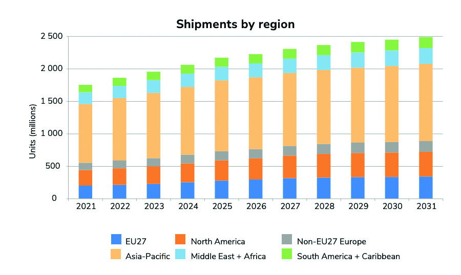
GNSS receiver shipments will grow continuously in the next decade, from 1.8 bn units in 2021 to 2.5 bn units by 2031. (All images courtesy of EUSPA)
Growth dominated by consumer solutions
Between 2021 to 2031, yearly shipments of GNSS receivers are projected to grow from 1.8 billion units to 2.5 billion units. The shipments will be dominated by the consumer solutions, tourism and health segments as the global sales of smartphones and wearables continues to increase.
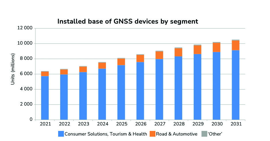
The overall installed base will increase from 6.5 bn units in 2021 to 10.6 bn units by 2031.
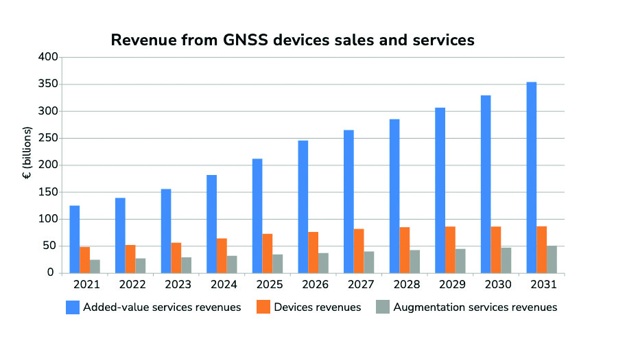
The global installed base of GNSS devices in use is expected to reach more than 10 billion units by 2031 — dominated by consumer solutions, tourism and health, and road and automotive market segments, which will contribute to 98% of all devices in use. The global GNSS downstream market revenues, which covers both device sales and service-related revenues, is expected to grow at a CAGR of 9.2% over the next decade, reaching €492 billion by 2031. More than 82% of the revenue will be generated by value-added services. Beyond the mass markets, the markets of agriculture, urban development and cultural heritage, and infrastructure will be the main contributors to the global GNSS revenue stream.
The Asia-Pacific region continues to be at the top of the GNSS revenue market both for device sales and service revenues based on demand. The region is expected to increase its share of the global services revenues, nearing 46% by 2031; however, it will see a decline of its market share of device revenues. The Asia-Pacific region will be challenged by the upcoming markets of South America and the Caribbean, Non-EU27 Europe, the Middle East, and African regions.
The GNSS market
The report defines the GNSS market as activities in which GNSS-based positioning, navigation and/or timing is a significant enabler for functionality. The GNSS market is comprised of device revenues, revenues derived from augmentation and added-value services attributable to GNSS.
The aviation and UAV market is expected to have significant growth, increasing from 42 m units in 2021 to 49 m units by 2031.The global GNSS downstream market revenues from both device sales and services will grow from €199 bn in 2021 to €492 bn by 2031 with a CAGR of 9.2%. This growth is mainly generated through the revenues from added-value services.
Augmentation services include software products, digital maps and GNSS augmentation subscriptions. Added-value service revenues include data downloaded through cellular networks specifically to run location-based applications, the GNSS-attributable revenues of smartphone apps, subscription revenues from fleet management services, and UAV service revenues across a range of industries. For multi-function devices such as smartphones, the revenues include only the value of GNSS-functionality, not the full device price, so, a case-specific correction factor is used.
About the charts
Data on the charts presented in the report start from the year 2020 and are estimated, projected and subject to update in the next edition of EUSPA’s Market Report. Historical figures are actual numbers based on reliable sources, per EUSPA. These will change if the number of applications is expanded in future reports.
Source: EUSPA EO and GNSS Market Report ISSUE 1, copyright EU Agency for the Space Programme, 2022
The new GSAGNSS Market Report is now available for download. The report provides a comprehensive overview of the GNSS market and the global industry, as well as a focus on EGNSS differentiators and synergies with Copernicus, according to the publisher, the European GNSS Agency (GSA).
Areas covered include:
A general overview of the GNSS market and a global industry overview.
Analysis of macro-trends affecting GNSS, including climate change and the circular economy, big data, artificial intelligence, the silver economy, cyber security and the sharing economy.
A review of the main GNSS market segments in detail, including trends and developments, forecasts for future shipments, revenues and the GNSS installed base, and a look into GNSS user requirements.
GNSS in Space. This year, the report features the “Editor’s Special: GNSS for NewSpace,” a section that introduces GNSS receivers in satellites and their relation to the evolving space sector.
GNSS market monitoring is a key activity of the GSA. Market monitoring supports GNSS stakeholders in their planning and decision-making, and offers a clear tool to understand GNSS trends and evolutions.
Since its launch in 2010, the GSAGNSS Market Report has become the go-to-source for information on the dynamic, global GNSS market segments and applications.
CHC Navigation has launched a new website to convey its expanding role as a provider of geospatial and GNSS products and solutions.
“Our new website provides a clear insight of who we are and where our ambition lies when developing, delivering and supporting high-end, professional and innovative GNSS-based solutions to our customers,” the company stated in a press release. “The website offers extensive refreshed and updated resources presenting the entire scope of CHCNAV solutions to make any surveying work more effective.”
In commenting on the new website, George Zhao, CEO of CHC Navigation said, “We have been enjoying double-digit growth for over 16 years demonstrating the strength of CHC Navigation in the professional GNSS-based markets. Our new website brings a comprehensive vision of our technology and innovation, expanding compelling solutions and our global customer care approach.”
Founded in 2003 and based in Shanghai, China, CHC Navigation creates GNSS navigation and positioning solutions.
MarketReports.biz has published a detailed market research study focused on the GNSS Market across the global, regional and country level.
The GNSS Market 2017 report provides a 360-degree analysis of the market from the point of view of manufacturers, regions, product types and end industries.
The research report analyses and provides the historical data along with current performance of the global GNSS industry, and estimates the future trend of GNSS market on the basis of this detailed study. The study shares “GNSS Market” performance both in terms of volume and revenue.
Companies mentioned include Harxon Corporation, NovAtel, Trimble, Tallysman, JAVAD GNSS, Stonex, Sokkia, Spectracom and Leica Geosystems.
The report provides a basic overview of the GNSS industry, including definitions, classifications, applications and industry chain structure. Development policies and plans are discussed as well as manufacturing processes and cost structures.
The report states the global GNSS market size and the segment markets by regions, types, applications and companies.
The GNSS market analysis is provided for major regions, including the U.S., Europe, China and Japan. For each region, market size and end users are analyzed as well as segment markets by types, applications and companies.
The report focuses on global major leading industry players with information such as company profiles, product picture and specifications, sales, market share and contact information. GNSS industry development trends and marketing channels also are analyzed. The feasibility of new investment projects and overall research conclusions also are discussed.
The report also provides major statistics on the state of the industry.
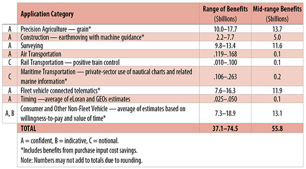
Table 1. Preliminary 2013 U.S. GPS economic benefit estimates. (Chart: GPS World, based on data from author)
This article is based on a presentation to the National Space-Based Positioning, Navigation and Timing Advisory Board in June 2015. The study reported on at the meeting was requested by the National Executive Committee for Space-Based Positioning, Navigation and Timing. It demonstrates the widespread use and importance of GPS to the U.S., with estimated benefits in 2013 of about $56 billion, or 0.3% of GDP for a subset of applications. The study is the first part of an effort that is expected to refine and extend this analysis.
By Irv Leveson
Critical to many civilian applications and innovations, GPS brings great economic benefits. These benefits have grown rapidly with the integration of GPS with other technologies and its wider and deeper infusion into applications. New GPS signals and other improvements in the system will further expand and enhance use. The unmistakable conclusion: GPS is everywhere.
Benefits of GPS to the U.S. will increase with the availability of other GNSS systems, even though GPS will constitute a smaller share of global GNSS benefits. The U.S. will continue to provide leadership, standards and innovation in technology and applications with positive domestic feedback.
GPS and other GNSS and enhancements raise productivity; reduce and avoid costs; save time; enable improved and new production processes, products and markets; increase health and well-being; reduce injury and loss of life; improve the environment; and increase security.
The National Executive Committee for Space-Based Positioning, Navigation and Timing (PNT), which is responsible for maintaining U.S. leadership in GNSS, commissioned a study to assign a quantitative value to the broad economic uses of GPS. The purpose is to inform the public, federal decision makers and critical infrastructure owners/operators on the importance of GPS and the need to protect it from disruption. Assessing the economic implications of actions such as preventing or disallowing interference, spectrum reallocation, developing supplementary or backup systems and/or toughening receivers can be informed by value estimates and the data used to derive them. In addition, economic values can contribute to planning for GPS modernization and analysis of budgets. Baseline estimates facilitate comparisons with future developments. GPS benefit estimates will be “ballpark” no matter how sophisticated the methodology because of limits to the availability of information, but in many cases, knowing orders of magnitude is essential in choosing courses of action.
Widespread, Pervasive Impact. The technological environment is one of rapid changes in information and materials technology and integration of technologies at levels ranging from systems on a chip to large-scale systems. GPS is increasingly integrated with other technologies and systems that build on each other to achieve greater outcomes.
The U.S. Department of Homeland Security counts GPS as an enabling technology because of its crucial role in 14 of the 16 industries that are classified as part of the nation’s critical infrastructure. It is useful to view GPS’ role as being especially important in “enabling the enablers,” industries that particularly support the rest of the economy and are at the forefront of economic growth. The most notable of these are transportation, communications, power and financial services.
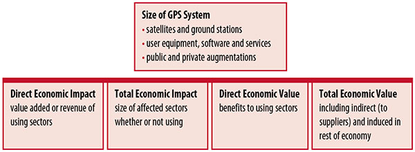
Economic Value versus Impact
Economic value is the addition to the value of the economy from the provision of a good or service, or the introduction of a technology. Benefits are measured relative to what would have been expected if there were no GPS. Direct economic value is the increase in value in using sectors. Total economic value includes increases in value to suppliers and value induced in the rest of the economy.
Direct economic impact, on the other hand, refers to measures of the importance of sectors that are using GPS. Total economic impact is the importance of sectors affected by GPS, whether they are using it or not. Total economic impact of GPS is virtually the size of the whole economy, so it is not very meaningful.
Direct economic impact is measured by value added of using sectors when the purpose is to avoid duplication among sectors that buy from and sell to each other. It may be measured by revenue for a single sector when adding sectors is not involved, so there is no need to avoid duplication.
The distinction between economic value and economic impact is critical. Even if economic impact is measured by value added rather than revenue, the value is not the net addition to the economy from the use of the product or technology. It is only the size of the using sector. See Figure 1.
Figure 1. Measuring GPS economic value and economic impact. (Chart: author)
The GSA Study
The most comprehensive estimates of global GNSS market size come from the European GNSS Agency (GSA), which has released four market reports from 2010 through 2015. The data are measures of economic impact and not economic value. The reports are of great interest because of their comprehensive global look at the sizes of markets and inclusion of forecasts. In contrast, the emphasis in this part of the present study is on current economic value, with U.S. benefits assessed for GPS.
One reason for interest in the GSA reports is that market information and projections often are proprietary and there can be great inconsistency across market research studies. GSA makes use of many confidential studies without revealing which sources contributed to each estimate. It apparently has been allowed to incorporate proprietary information from a number of market research firms since the data is subsumed in GSA’s own estimates and/or presented in graphs for which underlying numbers are not provided — and from which it is often difficult to even roughly extract them.
The 2015 report stated the methodology as: “The underlying forecasting model uses advanced forecasting techniques applied to a wide range of input data, assumptions and scenarios…Where possible, historical values are anchored to actual data.” Results were checked against opinions of market segment experts and market research reports. However, these analyses are not provided in the reports and have not been made available.
A distinction is made between the core market which covers the value of components that provide GNSS functionality in devices and enabled markets which “represent the services and devices enabled by GNSS.” The 2015 report provides global data on both core and enabled market and goes into much more detail on core markets for application sectors. In addition to providing sector information that did not appear previously, the 2015 report presents data on the extent to which each combination of the GNSS constellations was supported by receivers or chipsets offered by suppliers. Additional information on enabled sectors is in earlier reports.
GSA found in its 2015 market report that:
3.6 billion GNSS devices were in use globally in 2014, of which 3.08 billion were smartphones and .26 billion were for road.
North America had about 450 million devices installed (about 80% U.S.).
North America had 1.4 devices per capita in 2014.
North American shipments were 250–300 million in 2013.
Global core revenue was estimated at roughly €62 billion and enabled revenue at €227 billion in 2014. As noted, core revenue includes GNSS device components, software and services, while enabled revenue refers to applications.
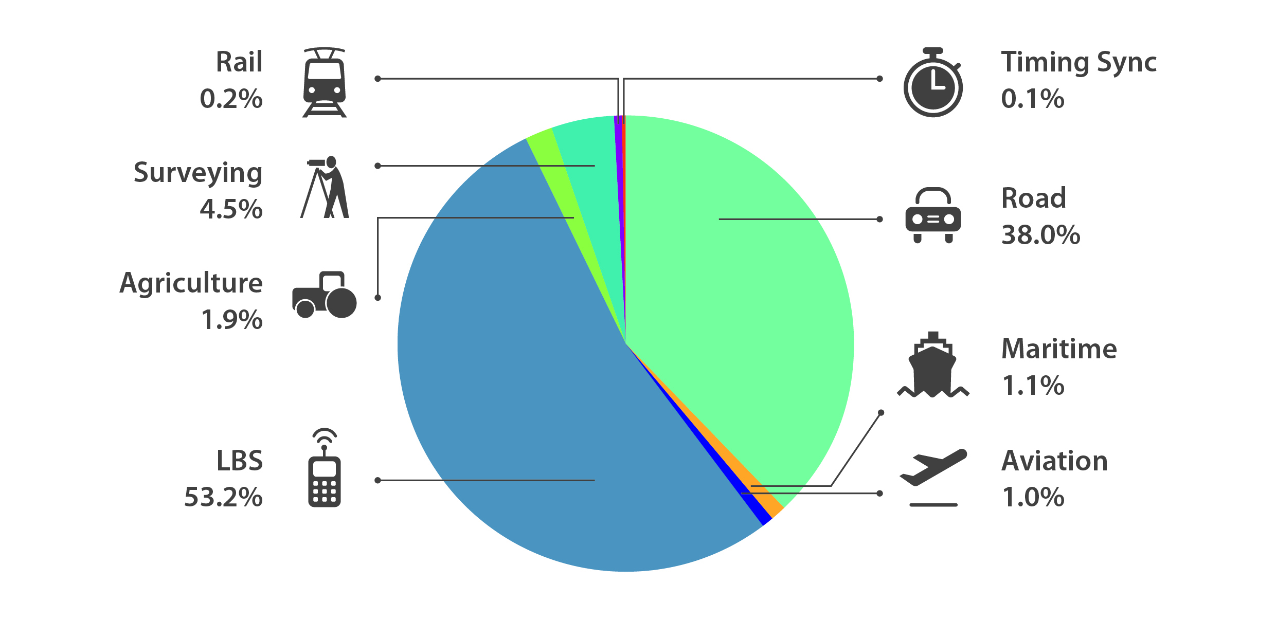
Location-based services (LBS) was projected to account for 53.2% of 2013–2023 core revenue growth, and road for 38%.
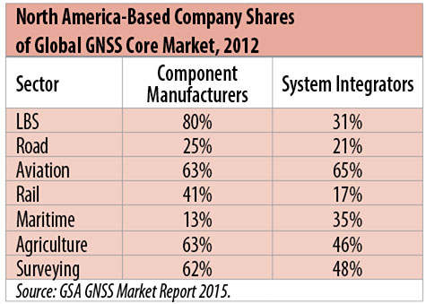
North American-based companies had sizeable shares of the global GNSS core market in 2012, particularly among component manufacturers. (See Table 2). Their market share among system integrators was highest in aviation.
North American-based companies had a 44% market share of value-added services revenue in 2012.
Table 2. North America-based company shares of Global GNSS core market, 2012. (Chart: author)
Markets and Applications
The pervasiveness of GPS-enabled applications is illustrated by the following statistics:
900 million mobile phones that incorporated GPS were sold globally in 2012.
The U.S. had 188 million smartphone subscribers and 263 million Internet users in 2013.
20% of U.S. mobile phone users get up-to-the-minute traffic or transit information.
The new industry category in the 2012 North American Industrial Classification System: “Internet publishing and broadcasting and web search portals” had U.S. revenue of $87 billion and 181,000 employees in 2012.
Google estimated that its search and advertising tools provided $111 billion in economic activity in the U.S. in 2013.
Deloitte estimated that Facebook enabled $104 billion of economic impact and 1.2 million jobs in North America in 2014.
Google Play and the Apple App Store each had more than 1.2 million apps in 2014.
How GPS Is Used. Uses of GPS include:
In agriculture for auto-steering tractors, combines and sprayers for precise operation, variable rate technology for precise placement of seed, fertilizer and pesticides, and for yield monitoring.
Managing forest health and ecological restoration, reducing fire and other hazards, and harvesting forest products.
In commercial fishing, navigation, finding fishing locations and monitoring fish catch by authorities.
In construction to direct the movement of dozers, excavators, pavers, scrapers, compactors and other heavy equipment and the placement of blades to give precise results.
In open-pit mining to guide loaders, dozers, drills and draglines.
In offshore energy exploration and development, for drilling, installations, pipe laying, diving operations, pipe inspection, repair and abandonment.
In surveying, to greatly reduce costs and to improve quality of products that rely on it.
In aviation, for navigation and monitoring positions of aircraft and for satellite-based augmentation systems (WAAS in the U.S.). GPS is the principal source for navigation for aircraft equipped with Area Navigation (RNAV) or Required Navigation Performance (RNP).
Railroad train pacing systems for cruise control, positive train control to keep track of train location and movement authorities, track defect location, and locating trucks with rail workers.
In marine transportation, for navigation, collision avoidance, communications and situational awareness and for monitoring by offshore authorities.
In vehicles, with handheld and embedded devices for navigation and fleet management.
For precise timing and time synchronization and frequency coordination (syntonization). It is used most notably in broadcasting and communications, including both cell phones and traditional telephone applications and the Internet, so packets arrive at the same time, for power generation and distribution to locate problems, and in financial services for time-stamping transactions.
In first responder services for location, navigation and communications and in emergency warnings and evacuations.
In structural monitoring of dams and bridges.
In environmental monitoring, including vegetation growth and sea-level change.
LBS and GIS
Rapid growth is taking place in location-based services (LBS) and geographic information services (GIS), which include everything from indoor location to many aspects of the Internet of Things and the “sharing economy,” and sophisticated systems for information management, analysis and display.
GPS is used for tracking and inventorying assets ranging from heavy machinery on farms and construction and mining sites, to pipes and other materials, containers in trucking sites and ports, and the location of utilities in the ground. In logistics it facilitates planning of product flow and transport.
The growth of same-day delivery — which takes advantage of Internet, cell phone, and location and navigation technologies enabled by GPS — is a continuation of the growth in just-in-time delivery that has been a phenomenon in manufacturing for several decades. Now it is having a profound effect on wholesale trade, retail trade and transportation.
The size of the LBS and GIS sectors is not defined and measured in a consistent way, and except for vehicle use, there is little information on productivity and saving in costs and time. (See sidebar box.)
LBS and GIS Market Size Estimates
For LBS and GIS, definitions and measures can vary greatly and often are not explicit.
Location-Based Services Market Size Estimates
Frost & Sullivan estimated the global LBS market at €22.8 billion in 2012 and forecast €32.0 billion in 2015.
Market and Markets estimated global LBS revenue at $8.1 billion in 2014.
Berg Insight estimated North American LBS revenue at $835 million in 2012.
(The U.S. can be assumed to spend 20–25% of the world value and about 80% of the North American value.)
Geographic information Systems Market Size Estimates
BCG estimated revenue of the U.S. GIS industry at $73 billion in 2011.
The global GIS market will reach $10.6 billion in 2015, according to a report of Global Industry Analysts in 2013.
The Canadian Geomatics study found private-sector spending of $2.3 billion in 2013. If U.S private spending was the same percentage of GDP, it would be $23.6 billion.
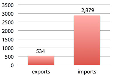
International Trade
Official data show a $2.3 billion U.S. deficit in trade in GPS equipment in 2013. This gives an incomplete and misleading picture of the role of the U.S. and the benefits that result. See Figure 2.
Figure 2. U.S. trade in GPS equipment, 2013 (millions of dollars). (Chart: author)
The trade numbers for GPS equipment do not include revenue for licensing, international payments received by social media and e-commerce companies, or other Internet-based revenue for which the U.S. may have a substantial net trade surplus and which are an important source of revenue and profits of U.S.-based companies.
Imports of GPS equipment software and services enable the U.S. to gain more efficient production in many applications at home and enable the U.S. to export more goods and service that rely on GPS.
Exports of GPS equipment come back to the U.S. as components that benefit U.S. businesses and consumers with more capable products and lower prices. Exports of GPS equipment enable other countries to build on the technologies and contribute to innovation, while imports enable the U.S. to share in foreign innovations. Exports of GPS equipment and associated knowledge also raise incomes in other countries, creating larger markets for U.S. goods and services.
Scope of Benefit Estimates
The U.S. benefit estimates reported here are the result of an initial effort and are not meant to be comprehensive. More work is expected to be done to fill in some of the gaps.
Sectors were chosen based on availability of information to permit relatively robust estimates and importance to the economy or policy issues. These considerations limited the number of sectors for which estimates could be made. Methods were determined based on the nature of available studies and varied among sectors. Only economic benefits were included, with health and safety and environmental benefits left for later research.
Benefits include the value to users above their costs (consumer surplus). Benefits of GPS are compared with alternatives without GPS or an application using it (counterfactuals). Estimates are gross. They are not reduced by the costs of achieving the benefits. Contributions of augmentations are included, since a quantitative basis for separating them is not available.
Estimates were primarily benefits through productivity and cost savings in operations, with savings in input costs included where their magnitudes were clear. Benefits to the rest of the economy are not included. Illustrative allowances were made for the contributions of other technologies and systems to the outcomes examined.
In the case of GPS timing, the estimates were based on the costs avoided by not having to develop an alternative timing source on the assumption that the type of alternative source possible would have evolved from the time GPS became available. The measure does not represent the value of GPS time and synchronization to the nation and to users relative to the absence of a precise time and frequency source.
Government was included in the estimates for construction, surveying, and fleet and non-fleet vehicles. For timing and non-fleet vehicle benefits, two alternative measures are averaged. Sectors with lower quality estimates — rail and maritime transportation — were included because of their importance to the economy. Shares of benefits attributable to GPS were rough assumptions. More robust estimates would require extensive data collection and interviewing in studies greatly exceeding available time and resources.
The primary focus was on productivity improvements, cost savings and cost avoidance, where costs include users’ time. Productivity increases and cost reductions allow more to be produced with the same amount of resources in the sectors utilizing the technology or allow resources to be freed up for other purposes. In that sense, they are equivalent.
When benefits are measured by productivity gains or cost savings, much of consumer surplus (the value to users above what they pay) is implicitly included. Some sources measure value by willingness-to-pay. Willingness-to-pay includes consumer surplus. It also encompasses costs of the purchase and other costs incurred by the user.
Criteria for Selecting Sectors
The potential for making sector estimates of economic benefits was categorized in three basic levels:
confident: based on robust estimates.
indicative: based on one or more less robust estimates.
notional: illustrative, if major contributions of other technologies are not separated and estimates must be based on a plausible percentage of a larger benefit, or if information is not available and estimates must be based on a percentage of market size.
Choices among categories for estimation and estimation methods depended not only on which of the basic criteria are satisfied but also on the following additional criteria:
The importance of the sector to the economy, for example as an enabler of other activities.
The potential use of benefit estimates for the category as an input into analyses of the effects of signal disruption.
Several dozen studies were assessed to determine categories for inclusion and to select studies that can form the basis of estimation. Studies for use in estimation of benefits in a category were chosen according to how well they met the following criteria:
GPS. A test of introduction of GPS or comparison with and without GPS rather than benefits of a broader service.
Coverage. Estimates that cover a major part of the category.
Robustness of estimates, including the type of review the source is likely to have had.
Consistency. If alternative better estimates are not in such a wide range that an average is less meaningful except where explainable by expected sources of variation.
Timeliness. Preference to a recent period being covered by the estimates.
U.S. Economic Benefit Estimates
Preliminary estimates of economic benefits for included U.S. sectors totaled $55.8 billion in 2013. Averaging the alternative estimates, the sum of the benefits in the two vehicle categories is $25 billion, by far the largest of the sectors estimated. Next were agriculture with $13.7 billion, and surveying with $11.6 billion.
Economic benefits are underestimated for several reasons. Some sectors are not included because of lack of information on productivity and cost savings, namely LBS other than vehicle, including asset tracking and locating people; GIS and mapping other than nautical charts, forestry, fisheries, mining, energy exploration and development, land and coastal management, weather, and scientific applications and space.
Parts of others are not included: non-grain agriculture, construction other than earthmoving, GPS in aviation for some Area Navigation (RNAV) Standard Instrument Departure Routes (SIDs) and Standard Arrival Routes STARS) and Required Navigation Performance (RNP), and rail other than positive train control.
Some estimates are conservative. The value of saved time in non-fleet vehicle transportation is based on the recommendation of the Transportation Research Board rather than the much higher value used by the U.S. Department of Transportation.
Some types of benefits are not included — specifically, benefits of GPS timing applications above the cost of alternatives, and avoided income loss, property damage and medical costs associated with reduced accidents and improved emergency response.
Increases in benefits between 2003 and 2005 are not estimated.
And, as indicated, non-economic benefits such as those to health, safety, security, reduced loss of life and to the environment are not yet addressed.
Benefits as measured thus far are about 0.3% of GDP in one year. If all of the excluded sources of benefits were quantified, the benefits would be much larger.
Estimating Benefits for Sectors
U.S. economic benefits of GPS for grain farming were estimated for farms with grain sales of $250 million or more. The same method as was applied for earthmoving in construction.
A composite range of percentages of productivity gains and cost savings of 18–25% was determined from various studies. In the case of grain farming, benefits also come from yield increases due to improvements in plant health. The productivity gains used in the calculations incorporated both sources of benefits. Productivity was taken together with market size and an estimate of 68% adoption of technologies taking advantage of GPS to compute initial estimates of benefits. A notional adjustment was then made to exclude the contributions of other technologies and GNSSs. While having the adjustment determined by a group of experts would have been preferred, that was not possible with the time and resource constraints of the study.
Benefits of GPS machine guidance with earthmoving in construction were calculated based on an 8–12% share of construction for earthmoving operations, a benefit of 18–22% and a 20–25% adoption rate, relying on a number of sources.
For surveying, an estimate of market size was constructed based on U.S. Bureau of Labor Statistics data on numbers of surveyors, cartographers and photogrammetrists in the engineering services industry vs. the rest of the economy, together with revenue data for private surveying and mapping from the Economic Census. This was combined with a composite estimate of productivity gains over conventional surveying of 45–55% and an assumption of 100% adoption.
The benefit values for air transportation were estimated for the study by the Federal Aviation Administration (FAA) based on effects of WAAS and performance-based navigation (PBN). The rail estimates cover only positive train control, which is in early stages of implementation. Information is highly uncertain, but impacts as of 2013 are small. Maritime benefits were based on updating an earlier estimate of benefits of the private-sector value of nautical charts. The estimates for fleet vehicle-connected telematics were based on savings found in an extensive survey of fleet customers over a five-year period.
Timing benefits were based on the avoided costs from not having to develop an alternative source of timing. Alternatives considered were eLoran and a system of three geostationary satellites. Since there would have been strong pressures to develop an authoritative timing source in the absence of GPS timing, it was assumed that one of the alternatives would have been developed rather than assuming as in other cases that technologies in use when GPS became available would have continued in use.
Two estimates also were made for consumer and other non-fleet vehicle use. One was based on extrapolating results of a study of consumer willingness to pay for navigation services, and the other on time saved by navigation services.
Part of the benefits of LBS other than those that are vehicle-related and for GIS are implicitly included in estimates for sectors that use them.
Data and Research Needs
Additional work would be desirable to extend and refine the GPS economic benefit estimates, quantify safety-of-life and environmental benefits, examine international benefits, assess potential future benefits and consider loss from denial of GPS. Benefits of many new and rapidly growing services are yet to be quantified.
Systematic research is needed to fill in gaps in adoption, productivity and cost savings with comparative before-and-after studies as well as with case studies. Robust studies require major and often multi-year efforts involving targeted data collection, which are rarely done by government or academics for GNSS. Information needs to be much more granular, taking into account specific functions in which GNSS is used (such as plowing, seeding, fertilizing, harvesting), specific GNSS and non-GNSS technologies employed in each function at each site, and extent of their use.
Also, results for GPS might be improved or at least be more acceptable if the contribution of other technologies and GNSSs to measured benefits were assessed by a group of knowledgeable individuals rather than by a single researcher.
Information on market size, penetration and growth from market research firms, which tends to capture recent developments, is based on greatly varying sources and methods, resulting in major gaps and great divergence in estimates, especially in new or rapidly growing areas like LBS and GIS. The North American Industrial Classification System (NAICS) and its application in federal data collection such as in the Economic Census lags far behind in recognizing new categories and providing sufficient detail. Lags in data collection and research lead to understatement of the use and benefits of GPS.
Looking to the Future
Future benefits are expected to be even greater because of evolution of technologies, expansion of GNSS systems, creation of new products and markets, and growth and penetration of markets. The possibilities are suggested by the numerous nascent applications that have been emerging. Many will be enabled by expanding GNSS systems, signals and capabilities in conjunction with geographic expansion and increased capabilities in wireless systems.
The progression of platforms is long and growing: mainframes, PCs, mobile phones and other handheld devices, tablets, game controllers, wearables, TVs, home appliances, air and space — including planes, UAVs, satellites, planets, moons, rovers, rockets and spaceships.
The widespread availability of platforms and the growing ability to utilize them promises a long way to go in developing applications and deriving benefits.
Acknowledgments
The author thanks the PNT Advisory Board and Gov. Jim Geringer, liaison from the board to the study; Jason Kim of the Department of Commerce who oversaw the project; Jim Miller of NASA; and the members of the interagency Economic Study Team that advised the effort. Numerous additional people in and out of government provided information and assistance. Responsibility for the content and findings rests with the author.
IRV LEVESON, who has a Ph.D. in economics from Columbia University, is an economic and strategy consultant and founder of Leveson Consulting. He has done extensive work on GNSS markets and issues for more than 10 years. He is a member of the Institute of Navigation, the American Economic Association and the National Association for Business Economics.
Annual revenues from connected healthcare and fitness services will approach $2 billion by 2019, nearly six times the $320 million value estimated for this year, according to a report from Juniper Research.
The report, “Smart Wireless Devices: CE, Enterprise, Fitness, Healthcare, Payments 2015-2019,” says that connected healthcare devices and the data they generate will offer substantial benefits to both stakeholders and consumers, potentially improving preventative healthcare. However, deployments will initially be constrained by inconsistent regulation, alongside continued privacy concerns surrounding the sharing and security of personal data.
‘Quantified Others’ are Key
The research highlights the “quantified others” trend: the use of someone’s data by a professional or concerned party — such as a parent — to provide meaning and/or advice. Companies like GOQii and Filip Technologies are using this to provide services beyond mere data provision.
Although, this has the potential to be undermined by unreliable data. While medical devices have validation standards, fitness devices have no such benchmark. The development of standards would alleviate consumer and medical professionals’ concerns, driving up adoption.
Software to Drive Connected Devices Forward
“Connected fitness and health devices provide a way to collect biometric data, not interaction platforms,” said author James Moar. “People want to interact with the devices at the app level – the draw is the information. Because of this, and the omnipresence of sensors, the importance of the hardware will diminish at a much faster rate than other CE market segments.”
Other Findings from the Report
Other findings were mentioned in a news release from Juniper Research, and are listed below:
“Smart Wireless Devices will permeate the enterprise, with smart glasses in particular having a large impact.”
“Mobile point-of-sale devices are poised to take off in developing markets, with several key players looking to move into Latin America and Asia Pacific in the coming years.”
“Smartwatches will be the most popular consumer electronics connected devices, overtaking more established wearable cameras.”
The white paper, Smart Wireless Devices & the Internet of Me, is available to download from the Juniper website together with details of the full research and the Interactive Forecast Excel (IFxl).
First and foremost, let’s give a big hand to Adam and Anastasia, the two Galileo FOC satellites that were successfully launched on March 27. Following the not-so-successful Galileo launch in August, it was imperative that this go smoothly.
Although the Double-A launch occurred after the conclusion of this year’s Munich Satellite Navigation Summit, anticipation of the event set the context for the entire convocation. The summit is a fixture on the European and global GNSS calendar. It is always intense, often spectacular and sometimes leaves one with contradictory feelings. This year it took place March 24-26 and sought to determine the future of PNT, encouraging delegates to look into the crystal ball and predict developments.
If we go by the number of times these words were repeated during the three days of the summit, the future will hinge around compatibility and interoperability. The multi-constellation GNSS is already here. The elephant in the room remains, as always, interference, but here integration of alternative sensors and signals should hold the key to continuous and possibly resilient operations.
As usual the summit kicked off with a high-level plenary in the imposing Allerheiligen-Hofkirche (Court Church of All Saints) in the Residenz München, the Bavarian royal palace. The welcoming speeches and presentations were interspersed with some pleasant jazz, and the atmosphere was relaxed.
Into the Crystal Ball
Matthias Petschke, director of EU Satellite Navigation Programmes at the European Commission, admitted that 2014 had been difficult, but he was looking forward to 2015. Clearly the deployment of the Galileo infrastructure — especially the space segment — was critical, and the March 27 launch was very much on his mind. However, he expressed confidence that the launch would be fine and that satellite production was, and would remain, on schedule. In the long view, he stated: “We will make it for 2020,” signifying full operational capability (FOC).
He also talked about stimulating global markets to foster uptake of Galileo and EGNOS, and this was discussed by Carlo des Dorides, executive director of the European GNSS Agency (GSA). The ground infrastructure is very much in place and preparing for the Galileo exploitation phase. A significant milestone in that process would be finding the right partner to lead Galileo operations for the next ten years. A tender was now in process to find that organization or consortium. Des Dorides described the process as a competitive dialogue with the emphasis on finding a partner who can inspire new ideas and provide innovative solutions. The contract is big, worth around 1 billion euros.
Carlo des Dorides, Executive Director of the European GNSS Agency (GSA), discusses the 1 billion euro tender, now in process to find the organization or consortium to lead Galileo operations for the next ten years. Photo: GSA
He also emphasized the successes for EGNOS in the year. Almost 180 airports now benefit from EGNOS-enabled approaches and more than 70 percent of “GNSS-enabled” farmers in EU use the EU’s SBAS.
Johann-Dietrich Wörner, chairman of the German Aerospace Centre (DLR) — and the nominated next Director-General of ESA – highlighted the growing dependence of critical services on GNSS. In this context multiple systems were not a question of competition; it was all about redundancy and safety. Multi-GNSS improves availability, accuracy and reliability.
The view from the United States was given by Harold “Stormy” Martin, Director, National Coordination Office for Space-Based Positioning, Navigation, and Timing in Washington, D.C. The GPS fleet was now 30 strong in orbit including four successful launches in 2014 and he stated the 2014 averaged user range error to be 70 cms — the best ever — and improving year on year.
One major upcoming trend is a realization that there’s a need to establish a U.S.-wide backup coverage for GPS outage due to natural or man-made interference. The U.S. is currently assessing alternatives with a decision likely in summer 2015.
There was a particularly warm welcome from the audience for Michael Khailov, deputy head of Roscosmos and co-ordinator for GLONASS. Last year the Russians were conspicuous by their absence at the Munich Summit, but for 2015, despite the intervening local difficulty in Ukraine, they were back in force. Khailov claimed that the sustainable development of the world depends on GNSS. On more esoteric ground he stated that GLONASS had maintained stable operations in 2014 and three more satellites had bene launched. Further launches would depend on operational circumstances. The user domains for GLONASS were continuously expanding. Continuing the summit text he said that it was better [working] together than separately — in fact separately often doesn’t work at all and therefore we must continue to promote interoperability and the Munich Satellite Summit is a good forum for this.
Jianyun Chen of the China Satellite Navigation bureau also took up the theme of all GNSS together. Sixteen Beidou (pronounced — for the avoidance of doubt — as ‘bay-doe’) had been launched since 2007 and the Chinese had been in discussion with Russia to ensure full interoperability with GLONASS. This process will be repeated with GPS and Galileo.
GNSS Updates
One of the idiosyncrasies of the Munich Summit is its very discreet signage. If you don’t know where it is — and specifically the correct side door that brings you up two floors to the main Max Joseph Saal venue — it is highly likely you’ll miss it! But once you are in it is two full-on days of updates on systems and discussions on a vast range of topics that impinge on the development and implementation of GNSS around the world.
Discreet signage. Photo: GSA
The first two session of the summit proper gave updates on the GNSS systems in operation and under development as well as the regional and augmentation systems. Much of the material was slightly more detailed versions of presentations at the plenary but a few news snippet emerged.
“Stormy” Martin said that a modified battery charge control had been implemented that would extend operational life for some of the fleet by one or two years. He also reiterated the improving accuracy performance of GPS which was now much better that its published standards. He predicted that the first GPS III would be available for launch in 2016 and said that GPS was improving every day.
Eric Chatre from the European Commission reiterated that Galileo was still expecting to start early services in 2016 with full operational capability in 2020. He expected 18 satellites to be launched by 2018. The new Ariane 5 launcher will enable the launch of four satellites at one time and the first launch with this system would be in 2016. In terms of the ground segment only one station in the Pacific was yet to be established.
Sergey Karutin of Roscosmos talked about a four-fold accuracy improvement for GLONASS with the use of new clocks and the introduction of new CDMA signals that will improve accuracy and access. According to Dongfeng Yu of the China Satellite Navigation Office the BeiDou constellation is moving from “regional to global, active to passive” and is aiming for global coverage by 2020.
U.S. SBAS developments were covered by Deborah Lawrence of the Federal Aviation Administration (FAA). The Wide Area Augmentation System (WAAS) now has 100 percent coverage for LPV200 in CONUS. More than 41,000 runway ends are now included, and she predicted full completion in 2016.
Jean-Marc Pieplu of the GSA talked about EGNOS status. The next system release (2.4.1) should be published in Q3 2015 and will include a significant input on ionospheric corrections. Further service evolution includes a plan to declare LPV 200 in Q4 this year and EGNOS coverage will be extended to 72 deg North and ensure full coverage of the 28 EU member states.
The Russian Augmentation system SDCM performs at 0.8 metre accuracy according to Grigory Stupak of JSC / Russian Space Systems. He noted new validated SDCM ground stations had been established in Antarctica and Brazil and stated that global exploitation was a key objective for SDCM as its satellite coverage was very wide. GLONASS and GPS together could ensure complete coverage. He also indicated that work was in hand for SDCM SBAS service certification for LPV 200 and he called for providers of all WAAS to work closely together.
2020 Vision
After lunch we were offered the chance to hear some expert views on the future of GNSS and PNT with Prof Vidal Ashkenazi of Nottingham Scientific Limited asking for their vision of GNSS in 2020. By that year there should be 100-120 GNSS satellites in orbit, multi-constellation receivers would be the norm, but what would be the new applications and what were the challenges?
Jamming and spoofing would still be issues. Pierre Bouniol of Thales thought that in civil aircraft receivers would probably incorporate jamming indicators by 2020 to inform users when signals may be compromised. For Stuart Riley of Trimble the key was integration of other sensor signals to bridge any GNSS signal outage. Gang Mao of Unicore Communications Inc. in China considered multiple frequencies to be a big help in reducing the threat of jamming. Nigel Davies of QinetiQ agreed saying there were a host of technical solutions but key for success would be solutions that use low power, are low cost and feature high usability. He also noted that safety certification of receivers for use in driverless vehicles would be required and this challenging application would need the provision of robust continuous navigation — and sub-metre accuracy.
The future market for GNSS was also discussed in a session that unveiled the GSA’s 4th Issue of its comprehensive GNSS Market Report. With almost four billion GNSS devices used worldwide and all regions experiencing growth, GNSS represents an unprecedented business opportunity. Over the past 15 months the GSA’s team of market monitoring experts has taken a close look at all aspects of the GNSS marketplace with analysis of both hardware and software market opportunities, technology trends and future developments.
Gian-Gherardo Calini, Head of Market Development at GSA, gives highlights of the comprehensive GNSS Global Market report. He will deliver this information in an April 16 webinar hosted by GPS World. Photo: GSA
The top-line results were presented by Gian-Gherardo Calini, Head of Market Development at GSA. GNSS is one of the few growing markets in the world showing 12.7 percent CAGR. It is a very attractive market with volumes and revenues driven by mass market segments: the dominant two being Location-based services and transport applications. This latest edition includes information a new market segment: Timing and Synchronisation. One area that is not included is security and government applications. Mr Calini indicated that this information has been collected by the GSA team but as it is essentially for users of the Public Restricted Service (PRS) it was not included in the open report.
Although the report is very much “Galileo flavored,” its findings are of great importance and value to whole GNSS community and will be the subject of a GPS World webinar with Mr Calini and myself on 16 April. You can register — free — for this informative global perspective now.
A panel discussion followed and covered a range of topics and applications from aviation to agriculture. Again the consensus was that chips would become multi-constellation and quickly. Philippe Prats of STMicroelectronic outlined automotive applications from insurance applications to advanced driver assistance systems (ADAS).
The role of government mandates in establishing markets was seen as positive. The e911 mandate in the states had provided the seed for GPS integration into smartphones. Similarly authentication was also seem as a significant future market driver.
Multi frequency was also showing on industry’s radar and in a couple of years will be a reality thought Philippe Prats with the main motivation being better accuracy. Frank van Diggelen of Broadcom highlighted the recent GPS World feature demonstrating cm accuracy on a smartphone.
Legal Issues
A dedicated session on legal issues was not the best attended part of the conference, which is a shame as it had some serious points to raise and highlighted a gap that is opening up between our technical abilities in GNSS and the legal basis for its use. The Munich Summit is to be commended for its commitment to providing a platform for these issues every year; they are often ignored elsewhere.
Oliver Heinrichs, a partner at BHO Legal in Cologne, emphasised the need to establish a firm regulatory framework and to ensure that any decisions did not cross World Trade Organisation (WTO) provisions and the General Agreement on Tariffs and Trade (GATT). In particular the idea of mandating a specific GNSS for applications such as emergency response systems in cars may well be incompatible with WTO rules.
Amedeo Arena of Universitá degli Studi di Napoli Federico II in Naples noted that all GNSS players were members of the WTO and considered that GNSS services and their trade was definitely “caught by the GATTs” so no favouritism for ‘home’ systems should be allowed.
Another area of controversy is automated vehicles. In discussion after the session I learnt that current international conventions governing the use of motorised vehicles require a human supervisory role at all times. There will need to be some fundamental legal groundwork done before the first driverless vehicles will be allowed out on the road for real.
These are legally complex issues and certainty will only come from test cases. Talking of complexity Aleksey Bolkunov of the Russian Federal Space Agency revealed that the legal, regulatory and standardisation measures governing GLONASS and GNSS in Russia consisted of more than 900 documents originating at various different levels of the state. This clearly gave great scope for “regulatory collisions” and he is involved in work to develop a single regulatory framework that should eliminate the remaining barriers to GNSS use in Russia.
Emerging Applications
Peter Grognard of Galileo Services chaired a final session of the day on emerging applications. Bruno Bougard of Septentrio saw dependable accuracy as key to emerging markets. He thought high precision driven by surveying was becoming more and more mainstream. For autonomous driving the challenge was to provide cost-effective, dependable accuracy at 10-30cm that was safe, reliable, and always available. This would require multi GNSS, multiple signals, highly integrated sensors and transparent and open augmentation.
For Neil Gerein of Novatel the mantra is “Accuracy, availability, assurance.” Users needed availability to their PNT solutions at all times. He also saw future applications integrating GNSS with inertial sensors and correction systems for high accuracy without the need for a base station.
or Neil Gerein of Novatel the mantra is “Accuracy, availability, assurance.” Photo: GSA
Lionel Garin of Qualcomm Inc talked about ADAS. Safety was paramount and he foresaw the need for rigorous design and certification procedures similar to that required for the aviation market. Fortunately the industry has lots of expertise here. Philip Mattos of u-blox UK argued that a volume market is in femtocell and small cell synchronisation in mobile networks where GNSS is the lowest cost solution.
Tom Stansell praised geometry as the most important and unique ingredient supplied by multi constellation GNSS. And the second most important ingredient was interoperability. He doubted users would care where their signals originated and devices would still be generically described as ‘GPS’ into the future. Application growth will be stimulated by the better geometry supplied by multi-GNSS constellations. When the E6 signal became available he predicted that 10cm accuracy would enable reliable lane keeping for ADAS.
And Galileo will supply E6 for free said Ignacio Fernandez Hernandez from the European Commission. Ignacio works on the Galileo Commercial Service design and outlined some significant differentiators of the European system including its broad signal for high accuracy and better multipath resilience, more stable clocks and improved ionospheric modelling compared to GPS.
Lionel Garin sounded a note of caution at the end of the session when he noted that multi constellation ability was good, but he was not sure what was actually gained beyond two, or perhaps three, constellations.
GNSS for Weather
The final day of the conference saw a few fragile heads courtesy of the previous evening’s Summit Space Night 2015 sponsored by Airbus Defence & Space, which took place at the Filmcasino am Hofgarten close to the conference venue. And the first session, chaired by Oliver Montenbruck from the DLR, certainly required a clear focus as we were taken through the use of GNSS in space geodesy, space navigation and reflectometry.
Roland Pail from the Technical University, Munich described results from the satellite gravity missions GRACE and GOCE that looked at mass transport processes on our dynamic Earth. A particularly sobering animation showed the extent of ice mass loss from Greenland over the past decade. But what is role of gnss here? The ability to give precise positioning of the satellites and the fact that the satellite orbits carry information on the gravity field.
Atmosphere sounding using GNSS radio occultation allows precise atmospheric profiles with global coverage in all-weathers. Jens Wickert of the Helmholtz Centre Potsdam said that since 2006 these high vertical resolution profiles had been making a significant impact on the world’s weather forecasting including improved hurricane forecasts. It was also a bias free technique for observing global temperature change. With a multi-GNSS future new missions could be planned as more signals would reduce noise. Combining GNSS and reflectometry could enable accurate tsunami detection from space. Similarly Prof Antonio Rius from Barcelona was using reflected GNSS signals to determine data on the surface of the sea such as surface roughness, extent of sea ice and early warning of a tsunami.
Stefan Sassen of Airbus Defence & Space described the LION GNSS navigation receiver for MEO and LEO platforms. The unit was qualified since 2014 and now 50 were on order. LION is highly flexible with multi-frequency, multi-constellation and multi-antennae configurations possible. It was accurate enough for autonomous orbit raising (a few kms) and or station keeping (to within 100cm).
Finally Manfred Sust of RUAG Space GmbH said that space borne gnss receivers were true enabling technologies for Earth Observation missions as precise orbit determination was key to capturing sharper images.
Alternatives
The second session of the day returned to the practical issues around possible alternative or complementary PNT (APNT) systems. As GNSS becomes ubiquitous many terrestrial PNT systems are being decommissioned (LORAN, VOR), but the potential vulnerability of GNSS signals to interference is highlighting the need for backup. The challenge being to balance functionality and cost in the search for “plan ‘B’ for GNSS” as chairman Michael Meurer from DLR described it.
The FAA’s Deborah Lawrence reiterated her plans for scoping and implementing a backup system to cope with a GPS outage in the US. The FAA is currently engaging with stakeholders to define what the minimum operational target for a GPS outage should be to set the basis for procurement activity. The timeline for a final investment decision was now December 2018.
For Europe Gerhard Berz of Eurocontrol thought there were many potential APNT in place and the topic was in the SESAR 2020 research programme. He thought existing DME could potentially do the job in Europe as it had good coverage, but the challenge is to get good geometry and coverage at low altitudes, in remoter areas and over water.
Prof Per Enge of Stanford University “put the moose on the table” and pointed to the 978 and 1030 ranging frequencies as an existing system that could be used for positioning. But how accurate was it? Airborne experiments had shown good agreement with GPS positioning with an accuracy of around 100m and in turns 300m, which was good enough in an emergency. Further tests using a UAV at spider infested Camp Rogers had demonstrated APNT in flight with 50m error. The UAV itself was specifically developed to navigate using APNT while looking for GNSS jammers.
Wouter Pelgrum of Ohio University discussed the relative merits of eLORAN, which has high power – and therefore difficult to jam – and beyond line of site accuracy of less than 10m, and alternatives such as collocation of pseudolites with mobile phone cell towers. This could also enable high accuracy indoors positioning applications. He believed that APNT will need to be context specific and there was no single solution.
Belabbas Boubeker of the DLR discussed modular APNT concepts while Nick Ward of the UK’s General Lighthouse Authorities indicated there was no coordinated policy on resilient PNT in the European maritime sector at present but his authority and others were exploring the possibility of using eLORAN as a commercial enterprise. Nine transmitters were operational in Europe and the service had been declared in 2014.
Michael Hoppe of Fachstelle der WSV für Verkehrstechniken said resilient PNT was a core element of e-navigation for waterways. A combination of techniques such as medium frequency RF, AIS and eLoran could give good accuracy in areas of highest traffic. First results of trials were encouraging.
Processing Power
The final session of the Summit to grab my full attention was chaired by Frank van Diggelen of Broadcom. He led a wide ranging debate on GNSS receiver architecture trends and more generally the future of chip design and fabrication: are we approaching the end of Moore’s law and if so — what next?
Recently “The balance of power has moved back onto the GNSS chip” to enable lower device power use. To highlight current developments Frank described a couple of Broadcom products: the Broadcom 4773 “location hub” that is at the heart of the Samsung Galaxy 6 “super smart phone” and the 4774 that can access signals from all four GNSS constellations and will be shipping in early 2016 on new smartphones.
In fact earlier this year the 4774 was used to make a first fix using signals from four different GNSS constellations (with signals from one each of GPS, GLONASS, Galileo and BEIDOU satellites) and a significant event in terms of our multi-constellation future.
Greg Turetzky of Intel talked about the benefits and challenges for GNSS in advanced silicon processes. He noted that Intel is now shipping 14nm technology and plans were in hand for the next two generations (10nm and 7nm). Moore’s law has been a great enabler for modern society. If automobiles had taken a similar development in the same timeframe we would all be driving cars with a maximum speed of some 300 000 km/hour that cost us around 4 cents to buy!
The big challenge for GNSS architecture was to take advantage of the smaller geometries while greatly reducing standby power. The integration of multiple radio sources to provide a single location solution was key giving ubiquitous location capability that will improve the experience of every mobile product.
Looking into his crystal ball, Peter Anderson of Integrated Navigation Systems in the UK saw that integrating signals from complimentary technologies and sensors would be important but would lead to a greater demand for digital processing. He predicted that multiband receivers would become standard in consumer devices. He also pointed out that the worst potential source of GNSS jamming for a smartphone was the phone itself! The move to dual frequency would be helpful here.
An overview of the Chinese XIHE system for seamless outdoor and indoor location was given by Dongkai Yang of Beihang University. This Beidou Innovative application provides a LBS system based on gnss and mobile communication networks to give a “fusion of communication and positioning for indoor positioning”. The system is being demonstrated in four areas in China in shopping malls. The target for positioning accuracy in the system is for less than 3 metres indoors and less than 1 metre outdoors.
Franz Kreupl of Munich Technical University gave a sobering view of “life after silicon” – essentially it looks like there isn’t one. He outlined the limits to silicon technology such as tunnelling current and predicted some further progress could be made in reducing interconnect sizes and via circuit design. But new candidate materials for semiconductor electronics from carbon nanotubes to widely hailed 2-D materials graphene and MoS2 all suffer major issues that seem to make them non-starters.
But do we need to keep on miniaturizing? Norbert Schuhmann of Fraunhofer IIS in Nuremberg thought that technology downscaling would have an end in terms of the physics, but especially in terms of reasonable cost. He thought 7nm and 2020 was the end point for the physics but that in fact 28nm should be seen as the actual last node in Moore’s law as from then scaling has no longer also been the path for cost reduction. He saw silicon on insulator technology and monolithic 3-D integration as possible paths forward, but the technology sweet spot — and well suited for GNSS — was 55nm and a format that was already extensively used in automotive applications.
2015 GNSS Market Report: European GNSS Agency Provides a Fresh Look at Worldwide Growth
The fourth edition of the European GNSS Agency’s (GSA’s) GNSS Market Report provides a comprehensive source of knowledge on this dynamic global market. The report has become a key reference for organizations building their GNSS market strategies. The new edition provides:
Comprehensive updates on previous analyses;
New statistics of the GNSS receiver capabilities of the 31 top global manufacturers, offering in total more than 300 models;
Insights on the GNSS industry and regional shares of the GNSS market
A more granular segmentation of the global GNSS market, namely: European Union (EU28); North America (including the United States, Canada, Mexico); Asia-Pacific (including China, Japan, Australia, India, Republic of Korea); Non-EU28 Europe (Norway, Switzerland, Russia, Ukraine); Middle East and Africa (Turkey, Israel, South Africa, UAE, Saudi Arabia); South America and Caribbean (including Brazil, Argentina, Colombia, Guatemala)
Information on a new market segment: Timing and Synchronization
Plus additional applications within existing segments, such as recreational navigation, fishing vessels, personal locator beacons, emergency locator transmitters and digital tachograph.
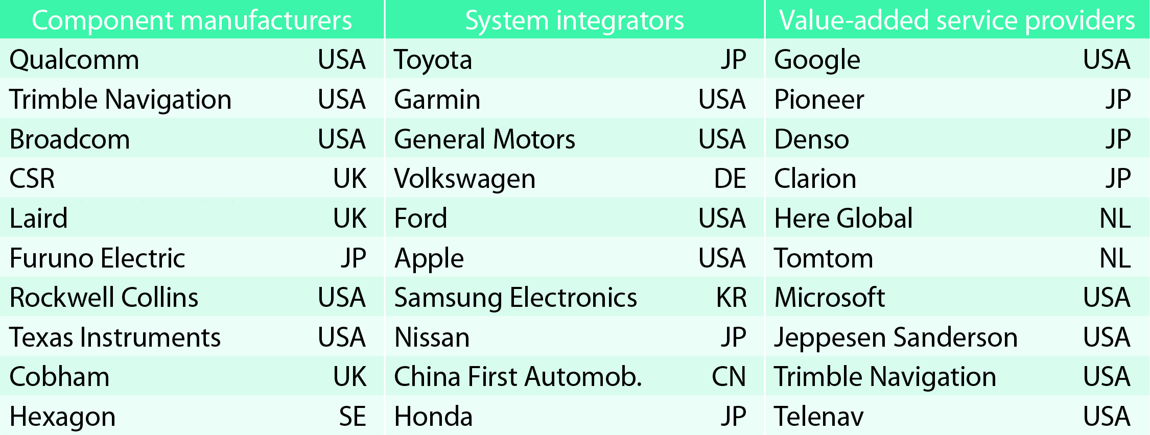
TABLE 1. Top 10 companies in each group based on 2012 revenue.
Key Findings
Top-line insights from the fourth GSA GNSS Market Report:
The global GNSS downstream market is forecast to increase by 8.3 percent annually from 2013– 2019, then slow down to 4.6 annually around 2023, growing on average faster (7 percent) than the forecast global GDP in this period (6.6 percent).
The installed base in the mature regions of EU28 and North America will grow steadily (8 percent per year) to 2023. The primary region of growth will be Asia-Pacific, which is forecast to grow 11 percent per year from 1.7 billion in 2014 to 4.2 billion devices in 2023 — more than the EU and North America together. The Middle East and Africa will grow at the fastest rate (19 percent per year), but starting from a lower base.
Location-Based Services (LBS) and Road dominate cumulative GNSS revenues, driven by booming sales of smartphones and in-vehicle devices, location-aware applications and data services.
With emerging economies catching up in terms of GNSS devices per capita, the Digital Divide will narrow, driven by the take-up of smartphones. The growing dominance of smartphones (3.08 billion in 2014) is foreseen as the most popular platform to access LBS.
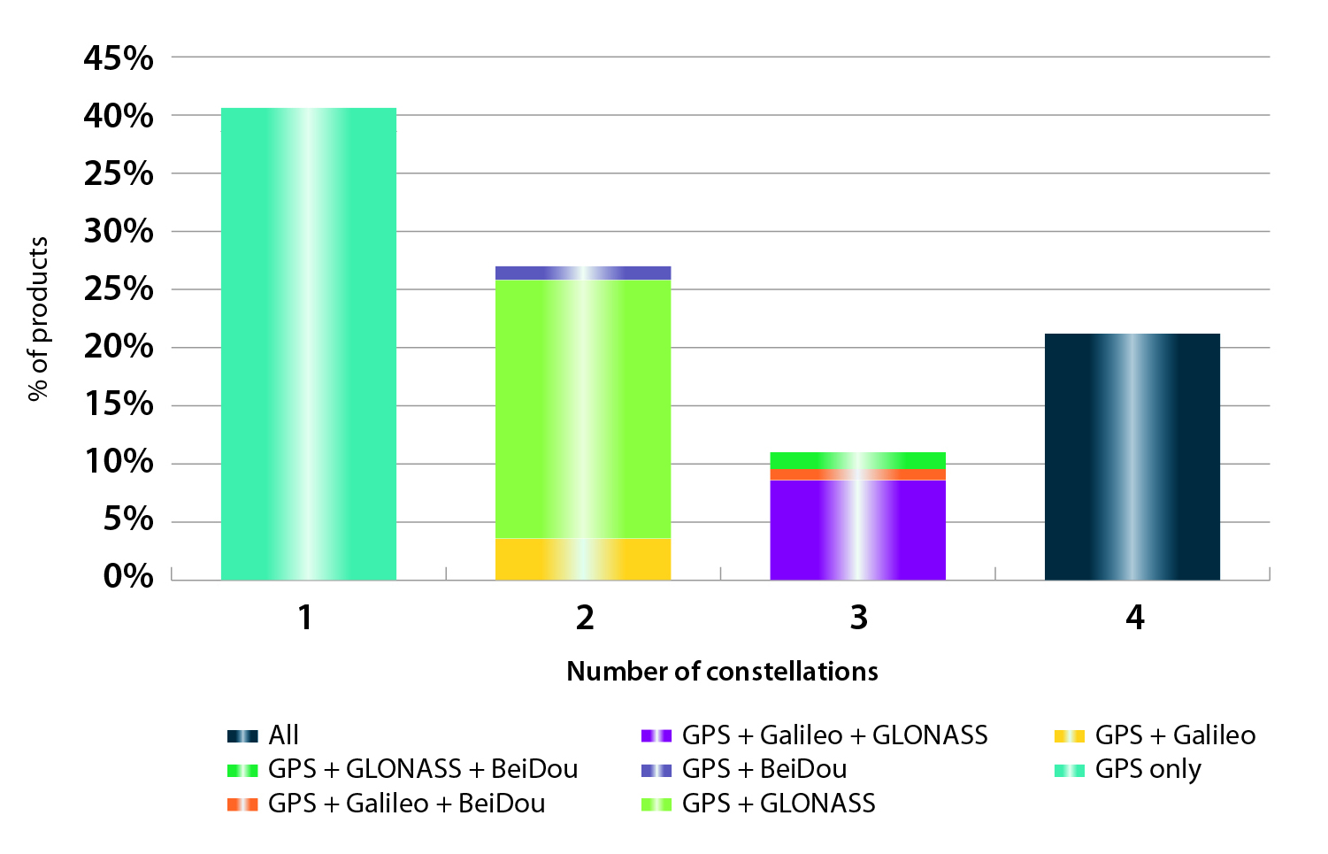
In the analysis of the capabilities of GNSS receivers and chipsets, it is reported that more than 60 percent of currently available receivers and chipsets support a minimum of two constellations with more than 20 percent supporting all four of them.
FIGURE 2. SUPPORTED CONSTELLATION BY RECEIVERS Chart shows the percentage of available receivers capable of tracking signals from one GNSS (such as GPS only), two GNSS (GPS + Galileo, GPS + GLONASS, GPS + BeiDou), three GNSS (GPS + Galileo + GLONASS, GPS + Galileo + BeiDou, GPS + GLONASS + BeiDou) or tracking signals from all constellations at the same time. The percentages add up to 100 percent. We can conclude that almost 60 percent of all available receivers, chipsets and modules are supporting a minimum of two constellations, showing that multi-constellation is becoming a standard feature across all market segments.
New Charts
The report includes new infographics presenting:
Global GNSS downstream market size, core and enabled (2013 to 2023)
GNSS industry share by region (2012)
The global shares of companies among components manufacturers, systems integrators and value-added service providers (2012)
Capability of GNSS receivers and chipsets, all segments (2015)
Supported constellation by receivers and chipsets , all segments (2015)
Detailed analysis of key GNSS segments: LBS, Road, Aviation, Rail, Maritime, Agriculture, Surveying, Timing and Synchronization, quantified in terms of:
Shipments of GNSS devices by application and region (2013 to 2023)
Installed base of GNSS devices by application and region (2013 to 2023)
Core revenues from GNSS device sales by application and region (2013 to 2023)
Capability of GNSS receivers and chipsets (2015)
Supported constellation by receivers and chipsets (2015).
FIGURE 3. LOCATION-BASED SERVICES SECTOR GNSS shipments by type; GNSS penetration in mobile phones is defined as the proportion of mobile telephones in use in the world that is GNSS enabled.FIGURE 4. ROAD SECTOR Core revenue from GNSS device sales and services by application.
Methodology
The “GSA GNSS Market Report” is compiled by the GSA and the European Commission and was produced using the GSA’s systematic Marketing Monitoring and Forecasting Process.
The underlying market model uses advanced forecasting techniques applied to a wide range of input data, assumptions, and scenarios to forecast the size of the GNSS market in terms of shipments, revenue and installed base of receivers.
Historical values are anchored to actual data in order to ensure a high level of accuracy. Assumptions are provided by expert opinions and model results are cross-checked against the most recent market research reports from independent sources, before being validated through an iterative consultation process with sector experts and stakeholders.
GPS/GNSS is now moving beyond cellular and traditional navigation markets, representing a market worth more than $3.3 billion in 2016, according to a new report by ABI Research.
GPS/GNSS has always been strongly tied to navigation in the in-car, PND, and cellular space, ABI Research said. However, GPS/GNSS is now finding applications in cameras, gaming, and tablets. Furthermore, femtocells and small cells represent huge volume opportunities, with companies like u-blox, Fastrax, and iPosi all developing specific GPS/GNSS solutions to meet the unique requirements of this market.
Location technologies such as Wi-Fi, Bluetooth, MEMs, and proprietary technologies from companies such as NextNav and Boeing will all see strong penetration. For example, the tablet market will be dominated by Wi-Fi location over the forecast period.
“Ultimately, GPS/GNSS manufacturers will need to combine an increasing number of technologies, supporting ubiquitous indoor and outdoor location,” said Patrick Connolly, senior analyst, telematics and navigation. “In 2012, CSR, Broadcom, and Qualcomm have all made announcements around increasing convergence of location technologies in the handset. This will meet the outdoor requirements of today, as well as supporting the emerging precision indoor location market.”
ABI Research’s market data, “GPS IC and Devices Forecasts, Global,” provides forecasts of GPS/GNSS ICs and market shares across nine key CE devices. It also provides forecasts for alternative/hybrid location technologies, providing a complete picture of the future location market.
The European GNSS Agency (GSA) has published its second Global Satellite Navigation System (GNSS) Market Report, providing key information to entrepreneurs in the satellite navigation sector.
GNSS market forecasting is of great interest to private and public GNSS stakeholders, for business and strategic planning and policymaking, according to the GSA. According to the 2012 GSA Market Monitoring Report, the worldwide GNSS market is growing fast and the total market size is expected to increase at an average of 13 percent per year until 2016.
The total enabled GNSS market size is expected to stabilise in the latter half of the decade due to market saturation, price erosion and platform convergence. Global shipments of GNSS devices are lower than previously forecasted up until 2015 yet are forecasted to continue growing to over 1.1 billion units per year.
Expanding coverage. Following up on the first GNSS Market Report published in 2010, the GSA’s 2012 Report includes an analysis of two new sectors: maritime and surveying. Relevant examples from EU research projects have also been included for each sector.
2012 Report Highlights
Road and location-based services (LBS) still in the lead. Road and LBS dominate GNSS device sales (54% and 44% respectively). LBS constitutes 87% of the total GNSS market in terms of units sold and GNSS penetration in smartphones is set to increase from 30% today to almost 100% in 2020. For road navigation, traditional Personal Navigation Devices (PNDs) will gradually disappear from the European market yet remain present in other regions in the form of low cost OEM products. Smartphones and in-vehicle devices will be the preferred means of navigation.
Commercial aviation use will grow. In the Aviation sector, the segment that will see the greatest growth in terms of GNSS equipment revenues will be Commercial Aviation, surpassing general and business aviation by 2018.
GNSS use in agriculture continues to rise. In agriculture the current positive growth trend will continue; low cost precision agriculture solutions based on EGNOS are driving GNSS adoption by farmers in Europe.
Surveying: a growing opportunity. In surveying, the construction segment is dominating the market in terms of units and value. North America is leading in terms of market penetration but the other regions will catch up by 2020 as GNSS is rapidly replacing the traditional surveying and mapping methods in Europe and around the world.
Safer seas with GNSS. In the open sea segment, shipments of search-and-rescue (SAR) beacons will exceed those of other categories making the SAR segment the largest in terms of shipments and second largest in terms of market size.
The European GNSS Agency (GSA) has published a 2010 GNSS Market Monitoring report, providing key information in support of entrepreneurship in the satellite navigation sector.
GNSS market forecasting is of great interest to private and public GNSS stakeholders, for business and strategic planning and policymaking, said the GSA. According to the new report, the market for GNSS will grow significantly over the next decade, at a compound annual growth rate (CAGR) of 11 percent, reaching €165 billion for the core GNSS market in 2020. Delivery of GNSS devices will exceed one billion per year by 2020.
“This Report confirms that the market potential of GNSS is significant,” said Gian Gherardo Calini, head of the GSA Market Development Department. “The information should be useful to researchers, market players and decision makers who want to grasp the GNSS market opportunities today and tomorrow.”
Report Highlights
Road leads the way: The report shows that the road transport sector is still the leading GNSS segment, accounting for more than 50% of market share. The penetration of receivers in road vehicles, today at 30%, will exceed 80% over the next decade. However, after a period of fast growth, market saturation and competition in the form of ‘smartphones’, often equipped with free navigation capabilities, have resulted in a slowdown in the car-based navigation market.
Price erosion has been high, driven by declining costs and strong competition. Vendors are using innovation as a differentiator resulting in ‘converged’ products with both communication and multimedia functionalities. Some Personal Navigation Device (PND) vendors are also tapping into new distribution channels, including car dealerships and smartphone application stores.
GNSS for road transport: The road transport sector is facing major challenges, such as the demand for increasing safety and for reduced congestion and pollution. These problems are particularly acute in highly populated zones, including big cities and suburban areas. GNSS represents a powerful tool for improving road transport. Not only does it help get drivers where they want to go more quickly and efficiently, but it also promises fairer road-pricing schemes, for example, to automatically charge drivers for the use of road infrastructure.
GNSS in your hands. Mobile location-based services (LBS) are taking off as progress is being made in different areas. More and more mobile phones now have GNSS capabilities, the result of both increasing consumer and developer awareness and an improvement in navigation services and performance.
All major mobile phone operating system vendors now provide application programming interfaces (API) with location functions. In 2009, in the UK, France and Germany, 5 out of the 10 best-selling iPhone applications were related to navigation or location-based applications. Also, 30% of Android developers’ contest winners used location capabilities in their applications.
A promising future for location-based services. The integration of accurate hand-held positioning signal receivers, within mobile telephones, personal digital assistants (PDAs), mp3 players, portable computers, even digital cameras and video devices, brings GNSS services directly to individuals, making possible a fundamental transformation of the way we work and play. The penetration of GNSS in mobile phones is therefore expected to increase very quickly, from some 20% today to above 50% within the next five years.
The GSA says Galileo in the future and EGNOS today open up new and exciting prospects for economic growth, benefiting citizens, businesses and governments throughout the EU and beyond.
Just the beginning. The GSA underlines that the GNSS Market Monitoring process is ongoing and future reports are planned to update information presented in this first report and to cover other sectors. The Agency welcomes stakeholder contributions.