Tag: GNSS receiver

  • Iridium hybrid IoT module now commercially available

    Iridium hybrid IoT module now commercially available

    The Iridium 9604 module and development kit streamline global IoT development with integrated satellite, cellular and GNSS connectivity

    Iridium Communications has announced commercial availability of the Iridium 9604 module and Development Kit, giving developers, OEMs and solution providers a faster path to build and scale connected IoT solutions worldwide.

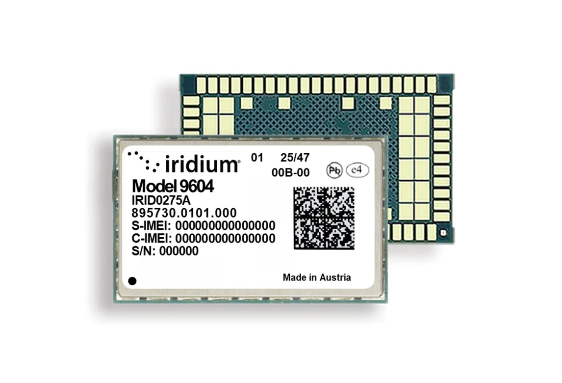
    Combining GNSS positioning, Iridium short burst data satellite connectivity, and LTE-M cellular, the Iridium 9604 module delivers a compact, integrated solution for global IoT deployments.

    The Iridium 9604 Development Kin, back side. (Credit: Iridium)
    The Iridium 9604 Development Kit, back side. (Credit: Iridium)

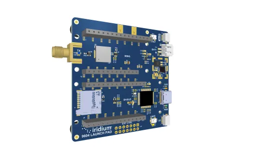
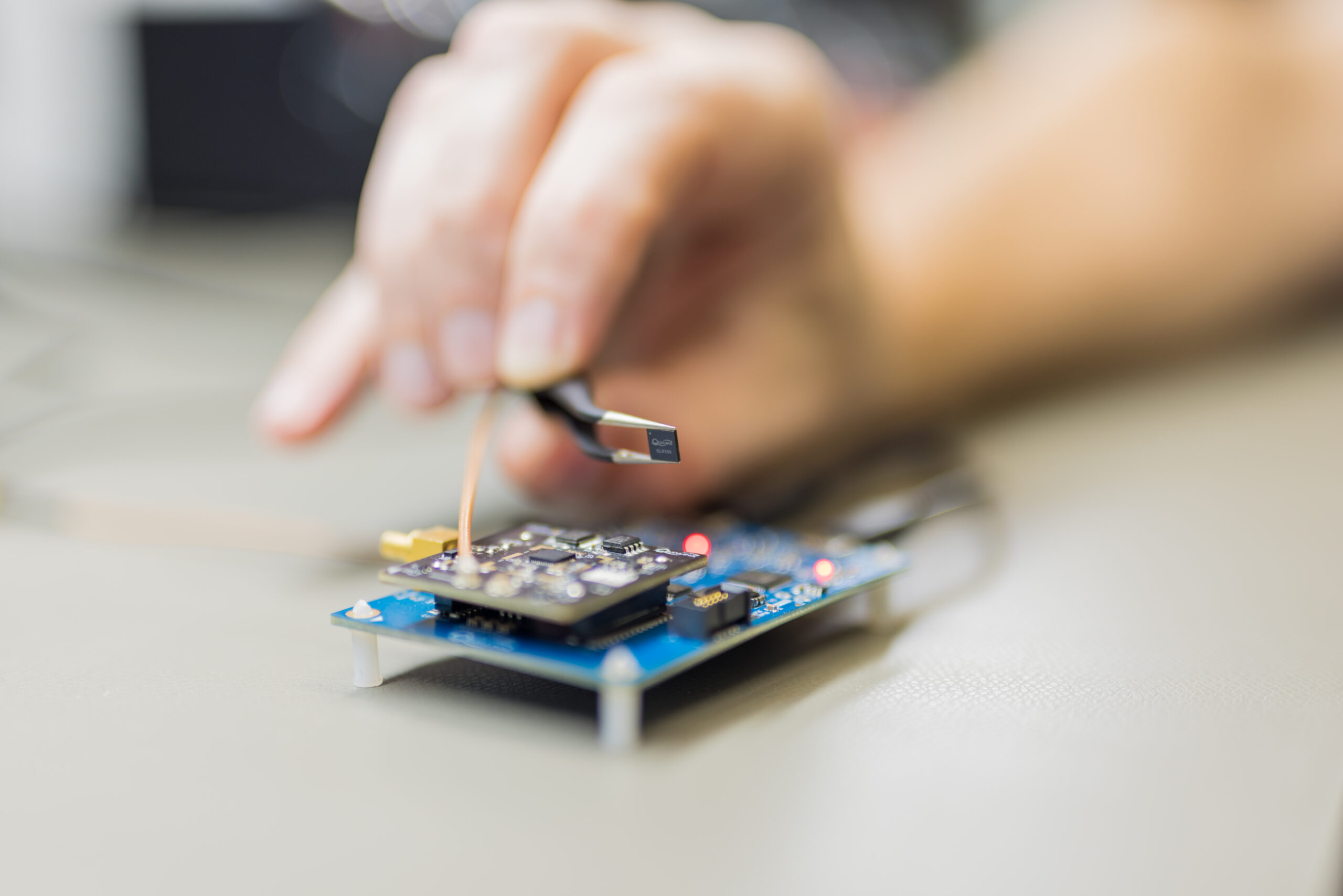
    Alongside the Iridium 9604 Development Kit, developers can rapidly prototype, test and validate hybrid satellite, cellular, and GNSS applications with resources that simplify integration and streamline deployment workflows.

    Built on the u-blox SARA-R5 platform, the Iridium 9604 is designed to reduce hardware complexity, lower integration costs, and accelerate time to market for connected solutions operating across industrial, infrastructure, transportation, mobility, utilities, maritime and remote-monitoring applications. The integrated design helps reduce board space requirements by 60 percent or more while simplifying RF routing, power architecture, and firmware development, Iridium said.

    Early developers and beta participants reported significant operational and economic benefits from the platform’s integrated architecture.

    “The Iridium 9604 has enabled us to develop a truly global asset tracking solution without relying on terrestrial network infrastructure. Its reliable coverage, compact form factor, and straightforward integration have significantly accelerated our development process and allowed us to focus on optimizing the end-user experience,” said Askar Gabit, CEO, GPSOne. “For applications in remote and challenging environments, the Iridium network provides the confidence that critical data can be delivered when it matters most.”

    The Iridium 9604 gives developers independent control over satellite, LTE-M and GNSS subsystems, enabling flexible implementation of failover logic, location-aware connectivity decisions, and application-specific routing strategies. A unified AT command set and comprehensive SDK resources further simplify development and integration.

    Built for scalable and power-sensitive IoT applications, the Iridium 9604 features a compact 16 x 26 x 2.4 mm form factor optimized for deployments where size, resiliency and efficiency are critical. The platform supports GPS, GLONASS, Galileo and BeiDou GNSS services alongside LTE-M (Cat-M1) and Iridium’s 100% global L-band satellite network.

    The Iridium 9604 represents the next evolution of Iridium’s broader IoT strategy, expanding beyond traditional satellite-only hardware to support unified, multi-mode connectivity architectures. The Iridium network now supports multiple IoT pathways, including dedicated Iridium SBD modules, Iridium NTN Direct standards-based direct-to-device capabilities, and larger payload connectivity through the Iridium Certus 9704 module.

    Operating on a global mobile satellite network, the Iridium 9604 delivers reliable connectivity across remote land areas, oceans, airways and polar regions where other networks are unavailable or unreliable.

  • With EUSPA support, Qualinx integrates Galileo OSNMA to receiver

    With EUSPA support, Qualinx integrates Galileo OSNMA to receiver

    The QLX3Gx chip makes secure, authenticated positioning a standard feature

    Qualinx has integrated support for the Galileo OSNMA (Open Service Navigation Message Authentication) on its QLX3Gx Series ultra-low-power GNSS receiver.

    Developed with the support of the European Union Agency for the Space Programme (EUSPA), the integration makes the QLX3Gx a GNSS receiver purpose-built for ultra-low-power markets to deliver hardware-native OSNMA support as a standard feature across the entire product family.

    Qualinx has embedded OSNMA support directly into the QLX3Gx hardware architecture from the ground up, enabling a fully optimized design with zero trade-offs in power consumption, cost or performance. 

    “Authenticated positioning has for too long been out of reach for the devices that need it most,” said Qualinx CEO Tom Trill. “By building OSNMA support into the QLX3Gx at the hardware level from day one, we’re making trusted positioning the default — not a premium option — for the wearables, asset trackers and IoT devices that make up the bulk of the GNSS market.” 

    The partnership with EUSPA reflects a shared commitment to disseminating Galileo’s advanced security capabilities across the widest possible range of applications and markets. EUSPA identifies OSNMA as a strategic priority for improving resilience against spoofing and signal manipulation

    According to the EU Space Market Report 2026, global GNSS revenues are projected to grow from €300 billion in 2024 to €580 billion by 2034 with mass-market devices accounting for the largest share of shipments and representing the greatest growth potential.

    Through Qualinx’s digital radio-frequency technology, the QLX3Gx delivers up to 10× lower power consumption than conventional GNSS solutions. By integrating OSNMA natively in hardware, the chip eliminates the processing overhead typically associated with authentication, ensuring security adds no meaningful cost to the power budget.

    The chip’s reconfigurable digital RF architecture enables capabilities to be updated over time without hardware replacement — extending device lifecycles, cutting electronic waste, and lowering overall energy consumption. The result is a platform that makes connected devices more secure and sustainable. 

    The QLX3Gx chip is available for sampling, with mass production planned for the second half of this year. Developers and OEMs can register interest in the Qualinx QLX3Gx Evaluation Kit to secure hands-on evaluation of the QLX3Gx for upcoming consumer, industrial and mobility applications. Contact [email protected] to register interest and request a sample, or learn more at Qualinx.io

  • Telit Cinterion launches GNSS Module in a legacy-compatible footprint

    Telit Cinterion launches GNSS Module in a legacy-compatible footprint

    Telit Cinterion has launched the SE869eK2L, a single-frequency L1 GNSS module designed to help device manufacturers upgrade legacy positioning designs with improved performance and cost efficiency, while preserving design continuity.

    Built on the Airoha AG3352 platform, the SE869eK2L supports GPS, GLONASS, Galileo, BeiDou and QZSS for reliable multiconstellation positioning. With approximately 1.5-meter accuracy and update rates of up to 10 Hz, it is well-suited for connected devices that require dependable positioning without the cost or complexity of higher-end GNSS architectures.

    For OEMs managing product refresh cycles, the SE869eK2L provides a straightforward migration path from Telit Cinterion’s SL869L-V2 and legacy xL869 modules. Its 12.2 x 16 mm footprint maintains pin-to-pin compatibility with the industry-standard form factor, so OEMs can extend existing designs while gaining updated performance and supply flexibility. The footprint includes reserved pins for future use.

    The module is designed for a broad range of IoT and industrial use cases, including:

    • Asset tracking
    • Fleet management
    • Smart infrastructure
    • Cell-tower synchronization
    • Industrial equipment
    • Wi-Fi 6E / 7 routers

    The SE869eK2L also supports connected devices that require reliable L1 positioning.

    Two hardware variants are available: a 3.3 V option and a 1.8 V option, allowing designers to align the module with their system architecture and power requirements.

    Dedicated firmware variants provide Windows Location Services compatibility and enable precise timing functionality, delivering synchronization output with ±7 ns jitter.

    The module also supports Wi‑Fi navigation mode, enabling compliance with Automated Frequency Coordination (AFC) requirements for Wi‑Fi 6E and Wi‑Fi 7 routers.

    Device manufacturers building connected products can pair the SE869eK2L with Telit Cinterion cellular modules — including those without embedded GNSS — simplifying sourcing, integration and support through a single supplier.

    Samples of the SE869eK2L are expected to be available soon, with mass production planned for the fourth quarter of 2026.

    Telit Cinterion will exhibit at Hardware Pioneers Max, Stand G4, where attendees can learn more about the company’s GNSS, cellular IoT and industrial connectivity portfolio.

  • Launchpad: New surveying & mapping systems, airborne lidar and more

    Launchpad: New surveying & mapping systems, airborne lidar and more

    Read a roundup of recent products in the GNSS and inertial positioning industry from the May/June 2026 issue of GPS World magazine.

    GNSS receiver

    Enclosed multi-frequency boxed receiver

    Septentrio

    The AsteRx EB GNSS receiver. (Credit: Septentrio)
    The AsteRx EB GNSS receiver. (Credit: Septentrio)

    The AsteRx EB offers high-accuracy positioning and GNSS heading for industrial robots, port logistics, marine and scalable automation applications. Its IP67 enclosure protects the receiver from harsh weather conditions, while built-in advanced GNSS+ algorithms ensure reliable operation in environments challenging for GNSS, such as areas with foliage or near GNSS interference sources. The RAIM+ integrity monitoring system ensures truthful positioning — essential for autonomous navigation. The compact enclosure of AsteRx EB enables easy installation, reducing time-to-market. In a dual-antenna configuration, AsteRx EB delivers sub-degree GNSS heading for systems that require orientation in addition to RTK positioning. The built-in AIM+ anti-jamming and anti-spoofing technology protects the receiver from intentional or unintentional GNSS interference.

    GNSS RTK platform

    Real-time kinematic delivers CM-level measurements

    SparkPNT

    Image: SparkPNT
    Image: SparkPNT

    The Facet FP is a high-precision GNSS receiver designed to deliver centimeter-level accuracy with a focus on long-term flexibility, ease of use and open-source innovation. It combines multi-band, multi-constellation GNSS support with fully open-source firmware — the platform can adapt as technologies advance. Built to last, all models are contained in a robust waterproof cast-aluminum housing, with an internal structure designed for compatibility with the company’s Flex system of GNSS modules. This gives users the choice between three different modules, plus the choice of having tilt-compensation, offering six different options with a range of price points, securities and accuracies for various needs and applications.

    GNSS antenna

    High-precision, high-accuracy, robust

    Hemisphere GNSS, Calian Group Ltd.

    Image: Hemisphere GNSS
    Image: Hemisphere GNSS

    The A65 GNSS antenna delivers exceptional accuracy, interference protection and robust GNSS tracking performance. Designed as a drop-in replacement for the widely deployed A45 antenna, the A65 offers users a seamless upgrade path to the latest precision technology. The industry collaboration reflects a shared focus on combining advanced RF design with real-world application insight to address increasingly complex GNSS operating environments, with both teams working closely from the earliest stages of development to meet demanding original equipment manufacturer (OEM) performance requirements. The antenna architecture, including the stacked patch quad feed element and RF front end, provides Calian’s XF Filtering. Hemisphere GNSS contributed application expertise, system integration requirements and performance validation within real-world machine control, agriculture, marine and survey environments.

    Airborne Lidar

    Long-range for UAV mapping and aerial surveillance

    CHC Navigation

    AlphaAir 6 is mounted on the X500 UAV during an urban mapping mission. (Credit: CHC Navgation)
    AlphaAir 6 is mounted on the X500 UAV during an urban mapping mission.
    (Credit: CHC Navgation)

    The AlphaAir 6 airborne lidar system is designed for UAV-based laser scanning, drone lidar mapping and aerial surveying in high-relief and complex terrain. Combining prism scanning technology with a high-grade inertial navigation system (INS), the AlphaAir 6 delivers a maximum ranging capability of up to 2,100 m and supports efficient data capture at typical flight altitudes of 400 m to 600 m above ground level. It integrates an upgraded laser engine and a high-grade IMU with 0.3°/h bias stability to improve trajectory accuracy and point cloud quality. This design removes the need for pre-mission IMU calibration and supports stable, efficient data collection for topographic mapping, corridor mapping, and wide-area aerial survey workflows. It is available in single-camera and dual-camera configurations.

    GNSS mapping app

    Makes smartphones data-collection tools

    Image: Fastxy
    Image: Digital Mapping Group

    Digital Mapping Group

    The FastXY mapping application for iOS and Android enables standard mobile devices to serve as professional-grade data-collection tools for geospatial information system (GIS) and architecture, engineering and construction (AEC) professionals. FastXY allows users to collect point, line and polygon data with devices they already own. It delivers advanced capabilities including 3D basemaps, construction staking, topographic surveying, on-the-fly datum transformations, and survey-grade elevations. A built-in Bluetooth data parser allows users to configure the app to collect data from any instrument supporting BLE Bluetooth or RS-232 — echosounders, radiation sensors, laser rangefinders, barcode scanners — and marry that data with precise GNSS coordinates.

  • Septentrio extends GNSS module family with mosaic-G5 P6

    Septentrio extends GNSS module family with mosaic-G5 P6

    Septentrio, part of Hexagon, has launched the mosaic-G5 P6 multi-frequency precise positioning module. The receiver, measuring 23 mm by 16 mm and weighing 2.2 grams, enables reliable positioning without performance compromises for commercial UAVs, robots and other size and power-constrained applications.

    AIM+ Premium technology protects the receiver from sophisticated intentional or unintentional GNSS jamming or malicious spoofing attacks.

    “By extending the mosaic family with mosaic-G5 P6, we are bringing an all-in-one module offering accuracy, resilience, and flexibility for demanding industrial applications,” said Yasmine Hunter, product manager at Septentrio. 

    The newly released module offers one of the highest update rates on the market, combined with low latency, essential for efficient and accurate control systems and navigation. In addition to high-accuracy positioning, raw measurements are also available for high-performance sensor fusion. 

    The mosaic-G5 P6 also offers users the flexibility to balance accuracy and availability and is compatible with Galileo High Accuracy Service (HAS) for decimeter-level positioning out of the box. Users can choose single- or dual-antenna configuration for accurate GNSS heading enabling robust orientation and motion control in industrial automation applications such as autonomous machinery, robotics and precision guidance systems.

    The new module is compatible with widely used, open-source autopilots like PX4 and ArduPilot as well as ROS, simplifying integration into robotic and drone systems. Its evaluation kitsimplifies testing with direct autopilot connections, while the free RxTools user interface assists with the setup and evaluation process.

    Meet our GNSS experts and see mosaic-G5 P6 during Xponential in Detroit, Michigan, May 11–14, at booth #37030. For more information about mosaic-G5 P6 or other Septentrio products, contact the Septentrio team.

  • Topcon launches innovations aimed at farmers at Brazil Agrishow

    Topcon launches innovations aimed at farmers at Brazil Agrishow

    As Brazilian farmers face increasing pressure to improve efficiency while managing rising input costs, Topcon Agriculture has announced a new set of innovations designed to expand access to precision technology across Latin America.

    At Agrishow 2026, taking place April 27–May 1 in Brazil, Topcon will showcase solutions for row crop, coffee, citrus and sugarcane growers, including an expansion of its Value Line portfolio into vineyard and orchard spraying applications, as well as the introduction of a new modular GNSS receiver for precision agriculture.

    XR-1P GNSS receiver

    Modular GNSS receiver. Topcon is introducing the XR-1P GNSS receiver, designed to deliver reliable positioning and manual guidance in a cost-effective, durable unit. Engineered with modular architecture, the XR-1P can be used as a standalone solution or integrated into broader Topcon systems, offering flexibility for a wide range of farming operations.

    The receiver is designed to bridge the gap between entry-level positioning solutions and high-performance precision agriculture systems, making advanced GNSS technology more accessible without compromising reliability.

    CM-20 V spray controller

    Expanding precision spraying for specialty crops. The CM-20 V Spray Controller, part of Topcon’s vineyard and orchard spraying control portfolio, is now available for use with the Value Line Steering solution. Designed for front-wheel-drive, mid-range tractors, the system offers an economical and scalable approach to precision spraying for specialty crops such as coffee and citrus.

    The universal ISOBUS electronic control unit (ECU) integrates easily with existing farm equipment, regardless of brand, while on-the-go sensor-based control adjusts application rates based on crop density. This helps reduce input waste, minimize over- and under-application, and improve overall crop health and operational efficiency.

    Sugarcane solution preview. An advanced look at a pre-commercial Sugarcane Yield Monitoring Solution will be showcased at the event. In development with the specific needs of Brazilian agriculture in mind, the solution will provide accurate, real-time yield visibility designed to maximize harvester efficiency, optimize logistics and support precision agronomy. By enabling more precise decision-making, the solution will help reduce input usage while increasing productivity in one of the country’s most strategic crops.

    Boom height controller

    Brazil is a strategic market for Topcon Agriculture, as it is one of the world’s leading food producers. Topcon supports the region not only through innovations tailored to local agricultural needs but also through a strong and expanding network of distributors that provide access to technology, training, and ongoing support. Authorized dealers, including Agrosure, Alagro, Coopercitrus and WiseAgri in Brazil, as well as Nievas in Argentina and Gestecner in Paraguay, will be at the Topcon stand during Agrishow.

  • Thales secures military navigation with TopStar Smart Receiver

    Thales secures military navigation with TopStar Smart Receiver

    Thales has launched the TopStar Smart Receiver, a three-in-one ultra-compact solution designed to provide land forces with resilient positioning, navigation and timing capabilities, while maintaining radio communications in increasingly contested electronic warfare environments.

    The TopStar Smart Receiver can be integrated into land vehicles, drones and munitions.

    Key features

    • Dual-constellation GNSS receiver. The receiver integrates signals from military constellations, Galileo PRS and civilian GPS, and provides resistance to spoofing with enhanced accuracy and availability.
    • Anti-jamming function. Its adaptive controlled radiation pattern antenna (CRPA) reduces interference from jammers, and enables operation at distances up to 30 times closer than with a conventional GPS receiver.
    • High-performance clock. The clock ensures synchronization of tactical radios for up to 48 hours following GNSS signal loss, versus 30 minutes with conventional equipment.

    Produced entirely within a sovereign European industrial base, the TopStar Smart Receiver is assembled at Thales’ site in Valence, France. The receiver is now available for testing in real-world conditions.

    “Powered by cutting-edge technologies, the TopStar Smart Receiver delivers resilient, high-performance PNT capabilities for land platforms, drones and munitions,” said  Florent Chauvancy, vice president of avionics and flight activities, Thales. “Innovative, reliable, competitive and compact, it ensures mission continuity in the most demanding operations, showcasing Thales’ expertise and commitment to innovation in support of the armed forces.”

  • Septentrio extends its boxed receiver range with AsteRx EB

    Septentrio extends its boxed receiver range with AsteRx EB

    Septentrio, part of Hexagon, offers a new enclosed multi-frequency GNSS receiver: AsteRx EB.

    The cost-effective product offers uncompromised high-accuracy positioning and GNSS heading for industrial robots, port logistics, marine, and scalable automation applications. Its IP67 enclosure protects the receiver from harsh weather conditions, while built-in advanced GNSS+ algorithms ensure reliable operation in environments that are challenging for GNSS, such as areas with foliage or near GNSS interference sources.

    The RAIM+ integrity monitoring system ensures truthful positioning, which is essential for autonomous navigation. The compact enclosure of AsteRx EB enables easy installation, reducing time-to-market.

    “AsteRx EB is an ideal boxed receiver for customers who need reliable, resilient, and highly accurate positioning in a compact form factor and at a price point that makes rapid scale-up possible,” said Danilo Sabbatini, Product Manager at Septentrio, part of Hexagon.

    In a dual-antenna configuration, AsteRx EB delivers sub-degree GNSS heading for systems that require orientation in addition to RTK positioning. The built-in  AIM+ anti-jamming and anti-spoofing technology protects the receiver from intentional or unintentional GNSS interference.

    AsteRx EB extends Septentrio’s lineup of enclosed GNSS receivers. Like mosaic-go, it can be used for quick and easy testing or evaluation of Septentrio’s reliable positioning technology. Thanks to its robust housing, it can be deployed in a wide range of industrial applications. For systems exposed to very harsh weather conditions or intense mechanical stress, the AsteRx RB3 ultra-rugged receiver provides the highest level of protection.

  • Juniper Spire GNSS receiver aimed at simplifying location data collection

    Juniper Spire GNSS receiver aimed at simplifying location data collection

    Juniper’s newest GNSS receiver, the Juniper Spire, is designed to simplify location data collection. With the Spire, users can achieve high-accuracy results with a light, compact design, one-button operation, and corrections services right out of the box.

    Built for rugged environments and long workdays, it offers seamless integration with mobile devices and data collection apps, making it a reliable companion for all GIS and asset mapping applications.

    It is designed for work in both remote areas and urban settings, and supports SBAS, Network RTK, and future correction services. Gather meter to centimeter-level data with our most forgiving antenna. With fast satellite acquisition, multi-constellation tracking, and extended battery life, it delivers consistent performance across a wide range of applications—from environmental monitoring to utility inspections.

    Key features include:

    • Accuracy down to the 2cm range
    • Worldwide corrections with SBAS, RTK, and future compatibilities
    • Latest u-blox model
    • Lightweight (<11.2oz)
    • Open interface (Windows 11, Android, iPhone/iPad)
    • Bluetooth connectivity
    • 16-hour battery life
  • SparkPNT launches RTK GNSS platform

    SparkPNT launches RTK GNSS platform

    SparkPNT has released the SparkPNT Facet FP, a high-precision GNSS receiver designed to deliver centimeter-level accuracy with a focus on long-term flexibility, ease of use, and open-source innovation.

    Built for a rapidly evolving positioning landscape, the Facet FP combines multi-band, multi-constellation GNSS support with fully open-source firmware — giving users a platform that can adapt as technologies continue to advance. Built to last, all models are contained in a robust waterproof cast-aluminum housing, with an internal structure designed for compatibility with the company’s Flex system of GNSS modules.

    This gives users the choice between three different modules, plus the choice of having tilt-compensation or not, offering six different options with a range of price-points, securities and accuracies for different needs and applications.  

    Other notable features include:

    • MFi Certification
    • LoRa radio with detachable antenna
    • Internal survey-grade L1/L2/L5/L6 GNSS antenna
    • IP-67 rated housing that blocks out dust, water and other environmental hazards
    • Internal fast-charging battery
    • WiFi and Bluetooth connectivity
    • Custom carrying case
  • ARK Electronics launches GNSS magnetometer unit for autonomous applications

    ARK Electronics launches GNSS magnetometer unit for autonomous applications

    ARK Electronics has launched the ARK DAN GPS, a U.S.-built dual-band L1/L5 GNSS and industrial magnetometer unit. The ARK DAN is designed for dependable navigation and orientation in professional drone and autonomous platform applications.

    Incorporating the u-blox DAN-F10N receiver, the system delivers resilient signal acquisition across L1, L5, E5a, and B2a frequency bands. Its integrated SAW-LNA-SAW design ensures robust immunity to interference, while proprietary dual-band multipath mitigation enhances positional reliability even in complex environments.

    An onboard ST IIS2MDC magnetometer provides stable heading data, complemented by a compact 4.4 cm × 4.4 cm × 1.3 cm form factor for flexible installation. The Pixhawk-standard UART/I2C interface and 6-pin JST-GH connector simplify integration into existing flight control architectures.

    With an efficient 5 V power draw averaging just 25 mA and a visual GPS fix indicator, the NDAA-compliant ARK DAN GPS combines performance, precision, and compliance in a lightweight, 25 g package.

    Specifications

    • Dimensions: 4.4 × 4.4 × 1.3 cm
    • Weight: 25 g
    • Power: 5V; 25mA average, 44mA max
    • Frequency Bands: L1/L5/E5a/B2a

  • Syslogic offers cm-accurate expansion board for embedded computers

    Syslogic offers cm-accurate expansion board for embedded computers

    Syslogic has introduced a GNSS expansion board for its rugged embedded computers. Based on u-blox GNSS technology, the board provides centimeter-level positioning, opening up new applications across industries such as autonomous field management, operation of construction machinery in remote areas, and navigation of automated guided vehicles (AGVs) and autonomous mobile robots.

    All-band, multi-frequency reception and HAS-ready

    Syslogic’s all-band GNSS board is powered by the u-blox X20 receiver, supporting all major GNSS constellations and frequencies, including L1, L2, L5, L6, and L-band. This enables the use of the upcoming Galileo High Accuracy Service (HAS).

    HAS supplements standard Galileo Open Service positioning with correction data transmitted directly over the E6/L6 band. The result is centimeter-level positioning via GNSS signals without the need for traditional RTK base stations, costly reference networks, or 5G connectivity.

    The u-blox X20-based GNSS board also supports simultaneous multi-frequency reception. With additional frequencies compared to previous models, typical GNSS errors, such as multipath effects and signal blockage, are significantly reduced, particularly in urban environments. This is crucial for applications that demand highly precise and reliable positioning, including surveying, autonomous vehicles, agricultural machinery and industrial automation.

    The GNSS board is designed for worldwide use. The integrated u-blox receiver supports modern correction techniques such as RTK, PPP-RTK and PPP. For the first time, it has been fully optimized for PointPerfect Global, u-blox’s proprietary high-precision GNSS correction service, delivering centimeter-level positioning anywhere in the world. This is particularly useful in remote areas without cellular coverage. PointPerfect Global uses advanced PPP-AR technology (precise point positioning with ambiguity resolution), providing corrections via the internet or L-band satellite transmission. The service achieves convergence times of less than two minutes and positioning accuracy within ten centimeters.

    RTK and Heading Capabilities Without Additional Hardware

    The new expansion board is compatible with Syslogic embedded computers, including both Nvidia Jetson-based and x86-based devices. It is available with either one or two receivers, enabling RTK and heading functions without additional hardware.

    Vehicles and machines can be positioned with centimeter-level accuracy. Several Syslogic customers are already using the GNSS functionality in pilot projects, including precision farming and construction machinery monitoring.

    Features of the Syslogic All-Band GNSS Board

    • based on u-blox X20
    • All-band, all constellation GNSS receiver
    • RTK, PPP-RTK and global PPP, cm-level accuracy
    • PPS output to host system (GPIO)
    • Galileo HAS support on L6 band
    • Flexible integration into Syslogic products
    • Extended temperature range from –40°C to +85°C.