PlanetiQ has been awarded a $15 million, 48-month Strategic Funding Increase (STRATFI) contract by the U.S. Air Force. The program will support the development and launch of spacecraft equipped with next-generation GNSS radio occultation (GNSS-RO) and GNSS polarimetric radio occultation (GNSS-PRO) instruments and the delivery of high-value weather data to the U.S. Air Force.
The mission will focus on advancing GNSS-RO, GNSS-PRO and GNSS reflectometry (GNSS-R) capabilities. The program includes the development of advanced data assimilation techniques to integrate enhanced GNSS-PRO data into numerical weather prediction (NWP) models, improving forecast accuracy and enabling new insights into atmospheric conditions.
After spacecraft commissioning, PlanetiQ will provide on-orbit data delivery during the contract period. This will support multiple applications across the Department of the Air Force, including artificial intelligence (AI) model training, data assimilation, and performance evaluation.
As the largest commercial provider of GNSS-RO data, PlanetiQ operates a global constellation of satellites, including spacecraft equipped with advanced receivers capable of capturing high signal-to-noise ratio (SNR) GNSS-RO and GNSS-PRO measurements. GNSS-PRO has demonstrated strong efficacy for measuring precipitation, a key capability for improving severe weather forecasting.
This STRATFI award will enable the development of a next-generation receiver that adds GNSS-R capabilities, supporting new applications such as ocean surface wind measurement, sea state characterization, and soil moisture monitoring over land.
“This award represents a major step forward in delivering more advanced, actionable weather information to the warfighter,” said Ira Scharf, CEO of PlanetiQ. “By combining GNSS-RO, PRO and R measurements in a single platform, we are unlocking a more complete picture of the atmosphere and Earth’s surface. We are proud to partner with the U.S. Air Force to accelerate these capabilities and bring next-generation environmental data into operational use.”
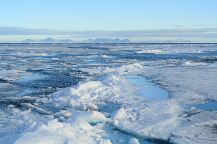
In recent years, scientists have shown that detecting changes in navigation signals from GPS and Galileo after they bounce off Earth’s surface (GNSS reflectometry, or GNSS-R) can deliver valuable information on sea ice. Now research drawing on data from Spire Global has enabled the generation of Arctic-wide sea ice maps, marking a major step forward for the emerging technique.
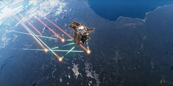
Spire Global‘s sea ice freeboard maps use data captured by Spire’s GNSS-reflectometry multipurpose listening constellation.
The research — enabled by the Third Party Missions (TPM) programme of the European Space Agency (ESA) — suggests that harnessing reflected navigation signals could become an important complement to established ice-monitoring altimetry missions.
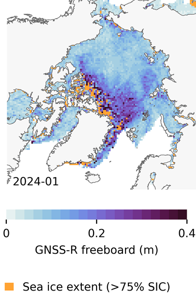
The study leveraged Spire’s GNSS-R data to retrieve sea ice freeboard measurements across an entire winter season. The results show strong alignment with established altimetry datasets, including the ESA’s CryoSat mission, validating the complementary role of commercial satellite data alongside government missions.
Arctic-wide sea ice freeboard map for January 2024. (Credit: ESA)
The study was led by Felix Müller at the Technical University of Munich (DGFI-TUM) and Robert Ricker at the Norwegian Research Centre, experts in GNSS-R.
“The primary purpose of signals emitted from GNSS is to fix the location of a device at any point on Earth,” Müller explained. “However, when these signals bounce off Earth’s surface, their properties change. By analyzing these changes, we can infer information about the characteristics of Earth’s surface.”
“Previous research has shown that this technique works well experimentally,” Ricker added. “Using the Spire constellation, we aimed to demonstrate whether it would hold up on a larger scale by generating an Arctic-wide map of sea ice freeboard, which is a measure of how far ice protrudes above the waterline.”
Spire’s GNSS-R constellation
Spire’s constellation was first used to sample the atmosphere for weather forecasting. Then scientists began exploring other applications. Spire started collecting reflected signals arriving at shallow angles using a technique called grazing-angle GNSS-R. This method is particularly well suited for ice monitoring.
The research team analyzed data detected over the Arctic Ocean and surrounding seas between October 2023 and July 2024. The data was obtained via the TPM program, through which ESA disseminates data from a range of commercial and institutional partners on a free basis for research and development purposes.
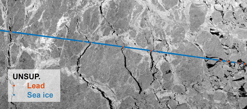
The team focused on one of the most critical challenges in sea ice altimetry: reliably identifying narrow openings in the ice pack, known as leads. These openings are reference points for determining sea surface height and, ultimately, sea ice freeboard.
In turn, sea ice freeboard can be used to infer sea ice thickness — an essential parameter for tracking climate change, estimating sea level, and modeling ocean and weather patterns.
Identifying leads in sea ice with GNSS-R data. (Credit: ESA)
Classifying surface properties
“In the initial phase of the project, we used two complementary methods to identify surface properties based on GNSS-R data, with the aim of identifying leads,” Müller said.
The first — known as the adaptive threshold technique — involved measuring the power of the reflected navigation signal to classify surface type as either water or ice. This method allows rapid processing of the entire GNSS-R dataset, while remaining robust to changes in signal conditions.
The second method — known as unsupervised clustering — offers a more complex approach to classifying surface conditions. In addition to signal power, it considers multiple other signal features that tease out more nuanced information on surface type, including identifying thin or refrozen ice.
Both methods were compared with co-located CryoSat surface-type classifications and Sentinel-1 imagery, confirming that the GNSS-R classifications were largely comparable against conventional satellite products.
Mapping sea ice freeboard
“Building on this classification work, we then took the research to the next step by producing Arctic-wide sea ice freeboard maps from GNSS-R data,” Ricker said.
The team corrected ice surface height measurements generated from GNSS-R data for tidal variations, sea surface height, and atmospheric delays, which is standard practice in altimetry. A refined algorithm then identified where leads in the ice were likely to occur, with the lowest points in these areas revealing estimated sea surface height. Sea surface height estimates were then subtracted from ice surface heights to retrieve freeboard. Using this approach, monthly gridded freeboard products were generated for the full winter season.
The team reported that the GNSS-R datasets showed strong agreement with CryoSat freeboard datasets across much of the Arctic, confirming that GNSS-R can reproduce large-scale patterns previously observed by dedicated altimetry missions. Independent validation against upward-looking sonar measurements in the Beaufort Sea further supported the accuracy of the retrieved freeboard values.
However, as expected, the GNSS-R estimates became less reliable during spring, when surface melt alters reflection characteristics. This limitation is consistent with earlier GNSS-R and radar altimetry studies and remains an active area of research.
The contribution of commercial data
While GNSS signals have long been used for positioning, this research highlights how reflected signal analysis can extend their value into large-scale Earth observation applications, delivering persistent coverage independent of sunlight or weather conditions, said Theresa Condor, Spire Global CEO.
“Advances in miniaturization, digital signal processing, and machine learning have fundamentally changed what’s possible in RF sensing,” Condor said. “Commercial constellations can now deliver persistent, high-quality RF data that complements traditional government systems with greater flexibility and cost efficiency.
“As environmental monitoring requirements intensify, we’re seeing agencies increasingly integrate commercially sourced RF datasets into operational architectures, reflecting the continued maturation of this market and the growing role of commercial infrastructure in government missions.”
“By producing analysis-ready gridded datasets, this work marks an important milestone in the progress of grazing angle GNSS-R from an experimental method to a reliable technique for mapping Arctic sea ice freeboard at scale,” said Matthieu Talpe, Remote Sensing Product Engineer, Spire Global. “In doing so, it strengthens the case for the grazing angle GNSS-R technique employed by the Spire constellation as a valuable complement to existing ESA and partner missions, helping to close observational gaps in one of Earth’s most rapidly changing regions.”
The European Space Agency’s first Scout mission, HydroGNSS, was launched Nov. 28, marking a significant step in advancing global understanding of water availability and the effects of climate change on Earth’s water cycle.
The two twin HydroGNSS satellites were carried into orbit at 19:44 CET aboard a SpaceX Falcon 9 rocket, as part of the Transporter-15 rideshare flight from the Vandenberg Space Force Base in California.
Less than 90 minutes after liftoff, the two satellites separated from the rocket. Then, at 22:45 CET, Surrey Satellite Technology Ltd. (SSTL) in the UK confirmed that they had received signals, indicating that both satellites were safely in orbit around Earth.
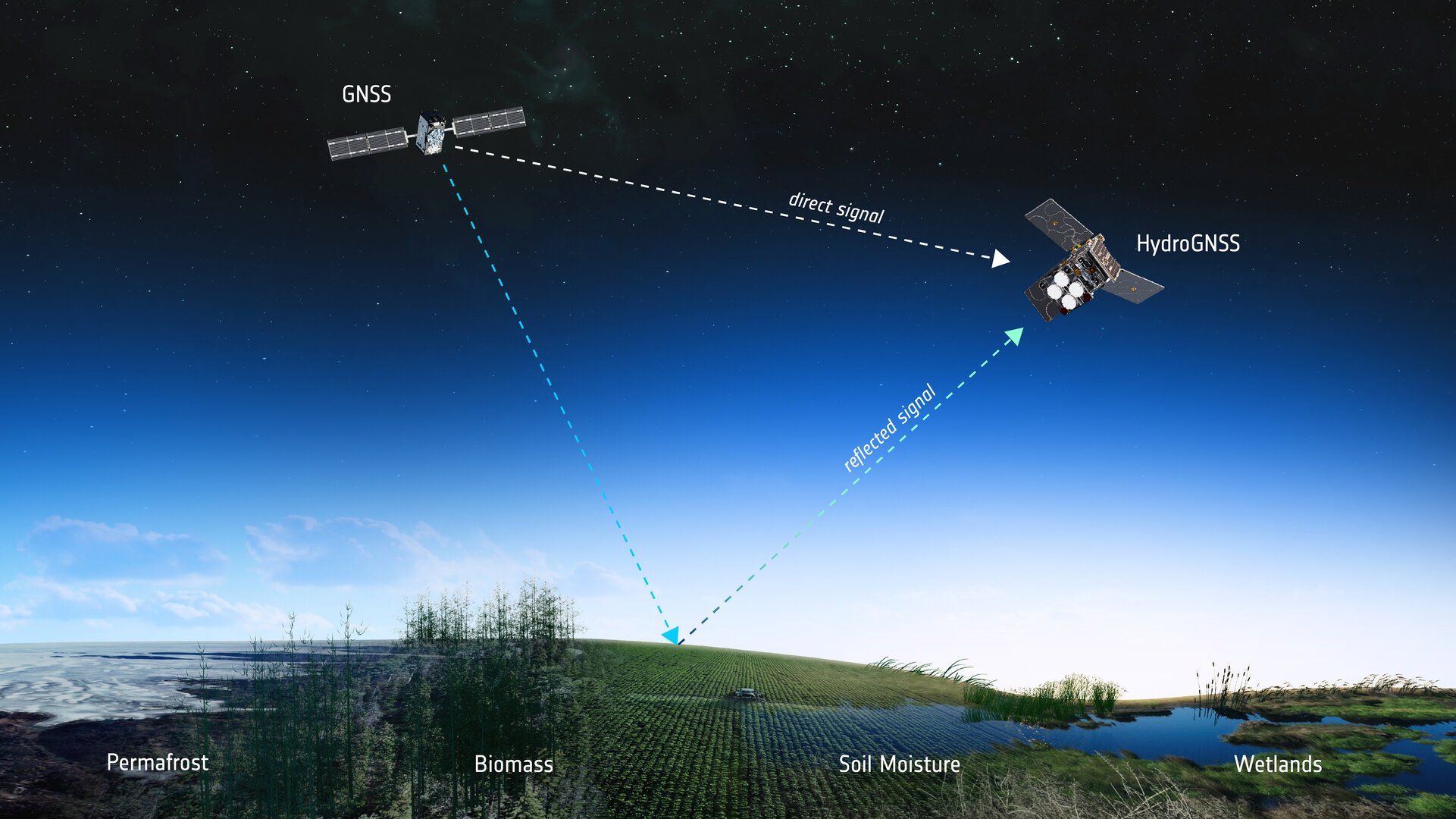
How GNSS reflectometry helps
Both satellites use GNSS reflectometry to scout for water by capturing L-band signals from navigation systems such as GPS and Galileo. These navigation satellites transmit L-band microwave signals that change when they are reflected off Earth’s surface.
The HydroGNSS satellites then compare these reflected signals with the signals the satellites receive directly from the GNSS satellites to reveal valuable information about the properties related to the water cycle, and more.
To do this, each HydroGNSS satellite carries a delay doppler mapping receiver and two antennas. A zenith antenna tracks direct GNSS signals and a nadir antenna collects reflected signals and processes them into delay Doppler maps.
Using this technique, the two small satellites, which orbit Earth 180 degrees apart, will measure soil moisture, freeze-thaw state, inundation and above-ground biomass.
Understanding the water cycle
The data will not only be vital for advancing our understanding of Earth’s water cycle, but also for supporting applications such as flood prediction and agricultural planning.
Also, by observing the extent of inundation and areas of wetland, HydroGNSS will help reveal wetlands – important ecosystems that can act as significant sources of methane – often hidden beneath forest canopies.
Information on freeze–thaw states will provide insight into the surface radiation balance, energy and carbon exchanges with the atmosphere, and the behaviour of subsurface permafrost in high latitudes.
Meanwhile, data on above-ground biomass will contribute to estimates of forest carbon stocks and their role in the global carbon cycle.
More Scouts to come
The Scout satellite missions harness small, smart satellites to shrink proven technologies or test bold new ways of observing the planet. Each mission races from concept to launch in three years, on a lean budget of €35 million that covers everything from design and construction to in-orbit operations.
“As the first of ESA’s Scout missions to launch, HydroGNSS marks an important milestone for this new family of rapid, low-cost Earth observation missions, and we extend our thanks to the mission’s prime contractor, SSTL,” said Simonetta Cheli, ESA’s director of Earth Observation Programmes. “The launch also represents a key step in the evolution of our FutureEO programme, where the Scouts embody a fast, agile, innovative and cost-efficient approach – complementing our larger Earth Explorer research missions.
“We now look forward to seeing how HydroGNSS will employ GNSS reflectometry to deliver valuable insights into key hydrological variables that shape Earth’s water cycle,” Cheli said.
ESA’s prime contractor for the HydroGNSS mission is SSTL in the UK. SSTL is also responsible for operating the satellites in orbit and for distributing the data. The mission is also thanks to partial funding from the UK Space Agency.
Two European Space Agency (ESA) microsatellites will soon be launched to study climate variables linked to water using GNSS reflectometry. The twin HydroGNSS satellites arrived at Vandenberg Space Force Base in California at the end of September, from where they will be launched later this month.
The HydroGNSS twins are the European Space Agency’s first Scout venture, part of the agency’s Earth Observation FutureEO programme. Scout missions are designed to deliver cutting-edge science quickly and affordably, complementing ESA’s larger Earth Explorer missions.
The identical microsatellites will launch from Vandenberg aboard a SpaceX Falcon 9 rocket, sharing their Transporter-15 ride into orbit with several other small satellites.
Since their arrival, the HydroGNSS satellites have undergone a series of final checks — including testing, propellant loading, battery charging and integration with their launch adapter. Both satellites are now ready for closing of the rocket fairing.
Once in orbit, the two satellites will travel 180 degrees apart around Earth to maximize coverage.
The mission focuses on four crucial variables, all recognized as “essential climate variables” or closely related to them: soil moisture, freeze–thaw state over permafrost, inundation and above-ground biomass. These data are vital for improving our understanding of Earth’s water cycle, including wetlands, permafrost dynamics and forest carbon storage. The data will aid in agricultural planning, flood prediction, and others areas.
HydroGNSS satellites will use GNSS reflectometry to measure key hydrological climate variables, including soil moisture, freeze–thaw state over permafrost, inundation and wetlands, and above-ground biomass. (Image: ESA)
Navigation satellites such as GPS and Galileo transmit L-band microwave signals that change when reflected off Earth’s surface. HydroGNSS will compare these reflected signals with the direct GNSS signals to extract valuable information about geophysical parameters related to the water cycle.
New Space missions. Inspired by the principles of New Space, the Scout programme emphasises agility and innovation — using small satellites to miniaturise proven technologies or demonstrate entirely new ways of observing Earth.
Each Scout mission must move from kick-off to launch within just three years and under a budget of €35 million, covering everything from satellite development to in-orbit commissioning. The resulting data are provided as a service to the scientific community and ESA, helping accelerate our understanding of the planet.
A team of researchers has developed a low-cost sensor that can detect the changes in river height to provide wide-area flood warnings.
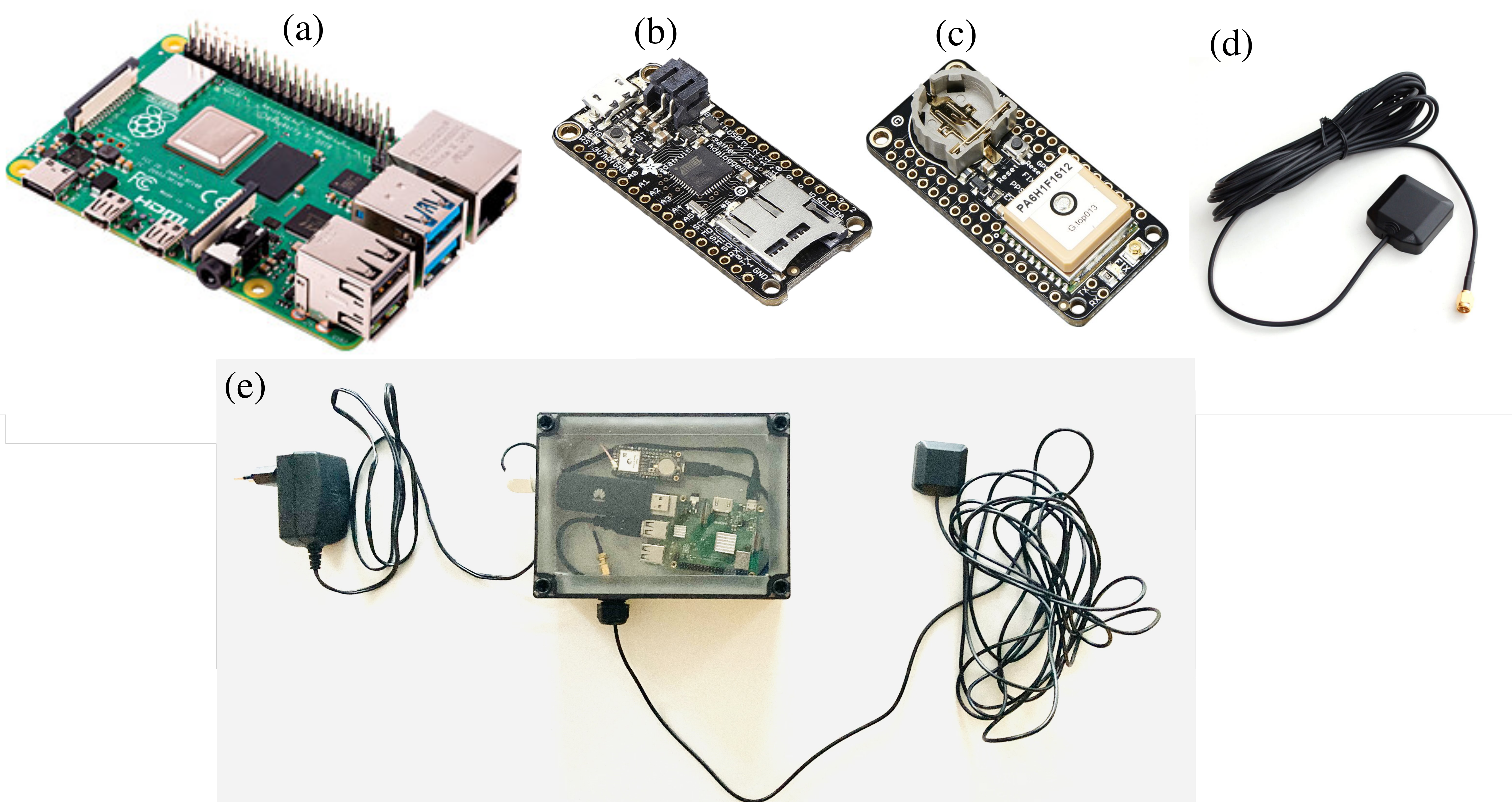
The Raspberry Pi Reflector (RPR) was designed by a team of scientists from the University of Bonn, the Federal University of Rio Grande do Sul, and the University of Colorado.
The solar-powered RPR is much less expensive (about US$150) than scientific-grade or geodetic GNSS instruments — the cost of which is “a limiting factor for their prompt and more widespread deployment as a dedicated environmental sensor,” the team writes in their paper.
The Raspberry Pi Reflector (RPR) prototype includes a low-cost and low-maintenance single-frequency GPS module (an Adafruit GPS FeatherWing receiver) and an unspecified GPS antenna connected to an inexpensive Raspberry Pi microcomputer. One such unit has been successfully operating since March 2020 in Wesel, Germany, next to the Rhine river.
The RPR hardware array: (a) Raspberry Pi 4 Model B (b) Adafruit Feather Adalogger microcontroller (c) Adafruit GPS FeatherWing receiver (d) GPS external antenna (e) Configuration of RPR prototype setup. (Image: Karegar, et al)
The unit on the Rhine provides sub-daily and daily water levels retrieved using spectral analysis of reflection data, or GNSS-reflectometry. The river level measurements from the RPR are compared with a co-located river gauge.
By changing the orientation of the antenna from upright to sideways facing the river, which was done in August 2021, the root-mean-square error (RMSE) was lowered to from 7.6 cm to 3 cm (sub-daily) and 6 cm to 1.5 cm (daily), the team said.
“While satellite radar altimetry techniques have been utilized to monitor water levels with global coverage, their measurements are associated with moderate uncertainties and temporal resolution,” the team states. “Therefore, such low-cost and high-precision instruments can be paired with satellite data for calibrating, validating and modeling purposes.”
Taiwan will launch its first indigenously developed meteorological satellite in March 2023, reports Taiwan News.
The Triton satellite was designed and made by the National Space Organization (NSPO) over eight years. The satellite has completed testing and is undergoing review.
The 250-kg Triton carries GNSS-reflectometry equipment (GNSS-R) — independently developed by NSPO — to collect GNSS signals reflected by the Earth’s surface. Its mission is to research air-sea interaction to help predict typhoons.
Taiwan is hit by typhoons every year. Information on wave height and sea-surface wind speed, retrieved from the reflected signals, will be useful for research on typhoon intensity and path prediction.
The satellite will be transported to the Guiana Space Center in January. It is scheduled to launch in March aboard a Vega C rocket manufactured by Arianespace.
“Seen & Heard” is a monthly feature of GPS World magazine, traveling the world to capture interesting and unusual news stories involving the GNSS/PNT industry.
A “BeiDou positioning system for subways” began construction March 20 on the Beijing subway capital airport express line. The project will cover a 30-kilometer-long section of the express line, including five stations. To provide positioning, the BeiDou Navigation Satellite System (BDS) will be combined with 5G for indoor positioning or in areas where the satellite signals are blocked. The system will improve the positioning accuracy in subways to less than 2 meters, making it available for vehicle dispatching, passenger transport organization and emergency response. In addition, it allows passengers to use their phones to navigate and position in complex environments in subway stations through three-dimensional navigation.
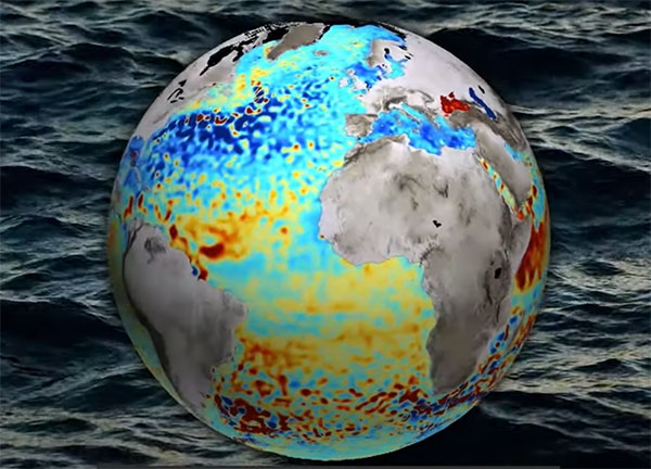
Image: ESA
THE SHAPE OF OCEAN WATER
The European Space Agency (ESA) investigated a technique to precisely measure sea-surface topography based on an idea submitted by the Institute for Space Studies of Catalonia (IEEC). The technique involves GNSS reflectometry — signals that have been reflected off of the sea surface at very low angles. The ESA-funded activity involved developing a GNSS receiver and setting up an experiment in the Balearic Islands to collect GNSS signals reflected off the sea surface. The team linked the coherence of the reflected signals to wave height and elevation angle of GNSS satellites. The team then processed the signals for optimized measurements of the shape of the sea surface, useful in applications such as ocean current forecasting, climate research, ship routing, cable laying and debris tracking.
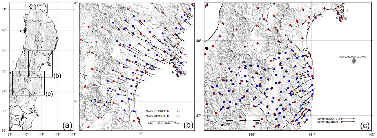
Image: Japan network/Ohta and Ohzono, Tohoku University
CELLPHONE NETWORK DETECTS EARTHQUAKES
A paper published Feb. 9 in Earth, Planets and Space by Japanese Earth science researchers analyzed the potential of a dense network of GNSS receivers, installed at cellphone base stations, to monitor crustal deformation as an early warning indicator of seismic activity. Results showed that data from a cellphone network can rival the precision of data from a government-run GNSS receiver network, while providing more complete geographic coverage. Japanese cellphone carriers have constructed networks of GNSS receivers to improve locational information for such purposes as automated driving. The study examined the potential of a GNSS network built by SoftBank Corp. to play a role in monitoring crustal deformation.
Photo: Falklands Maritime Heritage Trust
ENDURANCE IN POLAR ICE
Researchers have discovered the remarkably well-preserved wreck of polar explorer Ernest Shackleton’s ship, Endurance, a century after it was swallowed up by Antarctic ice. A team of marine archaeologists, engineers and other scientists used an icebreaker ship and underwater drones to locate the wreck at the bottom of the Weddell Sea, near the Antarctica Peninsula. The ship is at a depth of 3,008 meters, 4 miles south of the position originally recorded by navigator Frank Worsley. The expedition team used two Saab autonomous underwater vehicles to explore in a pre-programmed search pattern. After the ship was located, technicians swapped out sonar equipment for a high-resolution camera and a laser-surveying device to make highly detailed scans of the site.
Monitoring the constantly changing shape of the sea surface is important for scientific and societal applications such as ocean current forecasting, climate research, ship routing, cable laying and debris tracking.
A project supported by the Discovery element of ESA’s Basic Activities recently investigated a technique to precisely measure sea-surface topography. The project was based on an idea submitted by the Institute for Space Studies of Catalonia (IEEC) through the Open Space Innovation Platform (OSIP) — ESA’s place for your space ideas.
The technique involves GNSS reflectometry — signals that have been reflected off of the sea surface at very low angles. At these “grazing” angles, waves and surface roughness have little impact on the reflection process; the sea surface acts as a very smooth mirror.
“In a mirror-like reflection the phase of the signal can be tracked — it is continuous,” explained IEEC’s Estel Cardellach, principal investigator and submitter of the OSIP idea. “Different surface heights result in different phase measurements. It gives a very precise measurement of the surface altitude at a few centimetres’ precision.”
Balearic Islands Project
The ESA-funded activity involved developing a GNSS receiver and setting up an experiment in the Balearic Islands to collect GNSS signals reflected off the sea surface. The team — made up of IEEC, imedea, SOCIB and DLR — then processed the signals for optimized measurements of the shape of the sea surface.
“Thanks to OSIP and ESA Discovery we have been able to conduct this experiment on grazing GNSS reflectometry under monitored conditions,” said Manuel Martin-Neira, ESA technical officer for the project. “We have linked the coherence of the reflected signals to wave height and the elevation angle of GNSS satellites. These results have been very useful for preparing the PRETTY mission.”
ESA’s PRETTY (Passive REflecTomeTry and dosimetry) CubeSat mission is a small satellite that will carry out grazing angle GNSS altimetry from orbit. It is due to launch later this year.
The research satellite will in collecting high-quality, high-resolution data for terrestrial, coastal and ocean ecosystems for a three-year period after launch, according to Matthew McCabe, director of the KAUST Climate and Livability Initiative. McCabe described the launch as a qualitative process for the Kingdom’s efforts in the field of protecting and restoring ecosystems on land and at sea.
A CubeSat is a small satellite consisting of one or several 10x10x10 cm units, no more than 1.33 kilograms per unit. CubeSats can range from 1 unit (1U) to 12 units (12U). The KAUST satellite is 6U.
“In the past, launching a satellite was the sole domain of governments, with costs well beyond the reach of a university,” McCabe said. “CubeSats are helping to democratize space, providing the opportunity to launch a customized platform at a fraction of the traditional cost.”
The data collected will provide high-resolution details about current conditions of ecosystems in the region, and monitor improvements from environmental management strategies, supporting the Saudi Green Initiative among others.
The CubeSat is equipped with Spire’s GNSS reflectometry reflectors, as well as a hyperspectral imaging sensor. It is supported by advanced capabilities in processing and artificial intelligence.
The satellite will allow KAUST University researchers collect and analyze high-resolution images of the Earth’s surface for detailed mapping of terrestrial environments, monitoring of vegetation cover status, exploration of coastal ecosystems and coral reefs, development of precision agricultural research, and a host of other Earth and environmental science applications.
The imaging sensor can image areas of interest anywhere in the world across more than 30 user-adjustable spectral bands. The sensor data can be combined with Spire’s GNSS receiver to monitor micro-environmental variables such as soil moisture, helping in many areas such as agriculture, forestry and land management.
“The capacity to observe the Earth in high-resolution hyperspectral detail will allow for the production of enhanced metrics to map and monitor change anywhere in the world,” McCabe said. “Closer to home, Saudi Arabia is focusing considerable effort towards the protection and restoration of its precious terrestrial and ocean systems. The data from this KAUST CubeSat will be invaluable in providing new information on both the state of existing ecosystems, and for monitoring changes resulting from improved management strategies – something that can be used to support aspects of the Saudi and Middle East Green Initiatives.”
CICERO-2 satellites will track Earth’s atmosphere, water, surface and interior
Remote sensing company GeoOptics Inc. has upgraded its CICERO constellation of satellites that measure the Earth’s climate. With launches beginning next year, CICERO-2 will form a unified Earth observatory allowing governments, industry and individual stakeholders to monitor and prepare for the impacts of climate change.
“In today’s environment, in which precision Earth sensing is becoming ever more critical, GeoOptics is deploying a flexible observatory made up of dozens of small satellites,” said Alex Saltman, Chief Executive Officer of GeoOptics. “The real time services will satisfy a broad range of needs for government and civil users around the world.”
The first CICERO-2 satellites launched are designed to achieve key milestones in small satellite Earth observation, including:
Advanced GNSS reflectometry (GNSS-R). Advanced GNSS-R measures many phenomena near Earth’s surface, including ocean winds, flooding, land cover (snow, ice, vegetation), soil moisture and topography by means of reflected GNSS signals. NASA’s recent CYGNSS mission demonstrated the broad utility of the GNSS-R technique. GeoOptics is working with NASA’s Jet Propulsion Laboratory (JPL) to deploy an advanced operational version, offering dramatically enhanced performance in a small, low-cost package. This collaboration is funded jointly by GeoOptics, the U.S. Air Force, and NASA.
Triple radio occultation (GNSS-RO). GNSS-RO enables Profiling of atmospheric temperature, pressure, density and other key properties. First proposed by company founder Tom Yunck while he was at JPL, GNSS-RO offers extreme measurement precision and is an essential contributor to global weather forecasting. The CICERO-2 satellites will yield three times the data volume of their predecessors and many times the volume.
Global precipitation watch. The CICERO-2 satellites will monitor heavy precipitation using polarimetric radio occultation (RO), an advanced remote sensing technique pioneered by GeoOptics’ collaborators at JPL and the Spanish PAZ mission.
Measuring weather changes
For GeoOptics’ strategic partner Climavision, a weather data provider, these innovations will enable customers to manage significant risks in a time of global change. “With these new developments in remote-sensing technologies from GeoOptics, we’ll be able to further enhance our climate and weather prediction capabilities,” said Chris Goode, CEO and co-founder of Climavision. “Through the combination of advanced RO profiles, GNSS-R data about surface conditions and our proprietary gap-filling radar network data, we’ll help customers in weather-sensitive industries see weather like never before and give them the tools and data to make informed critical decisions.”
GeoOptics will later extend the system to a range of new applications, including precise mapping of Earth’s gravitational field, which has been named a top NASA Earth science priority for the next decade. This measurement shows the imprint of climate-related movement of water and other key changes in the Earth.
With internal investment and nearly $4 million from NASA, GeoOptics has devised a unique system architecture for daily gravity mapping with clusters of small satellites. This patented technique promises to improve gravity sensing 20-fold over current methods at a fraction of the cost.
Under the umbrella of the National Oceanographic Partnership Program (NOPP), GeoOptics is also designing a radar instrument to observe ocean vector winds, topography, soil moisture and a variety of other surface properties with patented multi-satellite radar techniques. NOPP is seeking to sponsor a trial flight of GeoOptics’Cellular Ocean Altimetry/Scatterometry Technology (COAST) within the next two years.
Tom Yunck, GeoOptics’ Chief Technology Officer, said, “These advanced remote sensing applications – from basic RO to advanced radar and gravity mapping – exploit shared micro technologies that fit in the palm of one’s hand. Each new function builds naturally upon the previous, yielding prodigious observing capacity in a low-cost system of great simplicity and reliability.”
“CICERO-2 is designed to help provide high-priority NOAA climate and weather monitoring observations, as ranked by the NOAA Space Platform Requirements Working Group (SPRWG),” said Conrad C. Lautenbacher (Vice Admiral, USN ret.), executive chairman of GeoOptics and former National Oceanic and Atmospheric Administration (NOAA) administrator. “It can also play a key role in supporting crucial Defense Department satellite weather data requirements.”
GeoOptics’ CICERO satellites continue to provide precise global profiles of the Earth’s atmosphere. In February, NOAA selected GeoOptics to provide the first commercial satellite data to be included in its operational forecasts.
In 2020, GeoOptics was selected by NOAA to lead an end-to-end design study for its next-generation low-orbiting weather satellite system, planned to come online later this decade, building in part on RO and GNSS-R technologies.
Spire Global, a global provider of space-based data and analytics, has announced the continuation of its participation in NASA’s Commercial Smallsat Data Acquisition (CSDA) Program with a $6 million contract extension.
The contract continuation, Task Order 6 (TO6), is a subscription data solution that includes radio occultation (RO) data, grazing angle GNSS-RO, total electron content (TEC) data, precise orbit determination (POD) data, soil moisture and ocean surface wind speed GNSS-Reflectometry data and magnetometer data.
This data will be available to all federal agencies, NASA-funded researchers and, more broadly, to all U.S. government-funded researchers for scientific purposes.
Under CSDA Program TO6, Spire will deliver a comprehensive catalog of data, associated metadata and ancillary information from its Earth-orbiting small-satellite constellation. The company operates its constellation in low Earth and collects upwards of 10,000 radio occultations per day with consistent global coverage.
For TO6, Spire will provide rolling access to 12 months of radio occultation data with a 30-day latency. This data will be archived and maintained by NASA under the CSDA Program’s SmallSat Data Explorer (SDX) database.
“Programs like CSDA highlight the incredible potential of private-public partnerships in the federal government to drastically accelerate our ability to confront some of the greatest challenges of our time, such as climate change,” said Peter Platzer, CEO of Spire. “With the end-user license agreements, our data is now available to all federal agencies and the larger NASA scientific community to help support Earth observation research across fields.”
The program includes end-user license agreements (EULAs) to enable broad levels of dissemination and shareability. All federal agencies and U.S. government-funded researchers will have access to Spire’s data for scientific purposes under TO6 and will be able to request access to the data via the CSDA Program’s Commercial Datasets webpage.
“At NASA, the CSDA Program has continued to blossom as a valuable resource to our team for our Earth observation research and analysis. We are committed to growing the program as well as continuing the work we have started,” said Will McCarty, project scientist at the CSDA Program and research meteorologist at NASA Global Modeling and Assimilation Office. “Spire has been a valued partner through CSDA’s development since its inception, and with this additional task order, we are excited about the new insights and results that will come not only from within NASA, but also through broader collaboration through the domestic government scientific community.”
NASA has used Spire data in its research on water and sea-ice levels in the polar regions, the height of the planetary boundary layer (PBL), and the day-to-day variability of thermospheric density at flight level.
NASA also noted that Spire data has shown positive benefit to its GEOS Atmospheric Data Assimilation System, which uses space-based data to analyze the Earth’s atmosphere and assimilate the data into its Earth observation systems.
As one of the original vendors for the CSDA Program, Spire provides NASA yearly updates to the scope of work under this agreement to ensure alignment of data to the agency’s needs.
Spire Global, a global provider of space-based data and analytics, has announced the continuation of its participation in NASA’s Commercial Smallsat Data Acquisition (CSDA) Program with a $6 million contract extension.
The contract continuation, Task Order 6 (TO6), is a subscription data solution that includes radio occultation (RO) data, grazing angle GNSS-RO, total electron content (TEC) data, precise orbit determination (POD) data, soil moisture and ocean surface wind speed GNSS reflectometry (GNSS-R) data and magnetometer data.
This data will be available to all federal agencies, NASA-funded researchers and, more broadly, to all U.S. government-funded researchers for scientific purposes.
Under CSDA Program TO6, Spire will deliver a comprehensive catalog of data, associated metadata and ancillary information from its Earth-orbiting small-satellite constellation. The company operates its constellation in low Earth orbit and collects upwards of 10,000 radio occultations per day with consistent global coverage.
For TO6, Spire will provide rolling access to 12 months of radio occultation data with a 30-day latency. This data will be archived and maintained by NASA under the CSDA Program’s SmallSat Data Explorer (SDX) database.
“Programs like CSDA highlight the incredible potential of private-public partnerships in the federal government to drastically accelerate our ability to confront some of the greatest challenges of our time, such as climate change,” said Peter Platzer, CEO of Spire. “With the end-user license agreements, our data is now available to all federal agencies and the larger NASA scientific community to help support Earth observation research across fields.”
The program includes end-user license agreements (EULAs) to enable broad levels of dissemination and shareability. All federal agencies and U.S. government-funded researchers will have access to Spire’s data for scientific purposes under TO6 and will be able to request access to the data via the CSDA Program’s Commercial Datasets webpage.
“At NASA, the CSDA Program has continued to blossom as a valuable resource to our team for our Earth observation research and analysis. We are committed to growing the program as well as continuing the work we have started,” said Will McCarty, project scientist at the CSDA Program and research meteorologist at NASA Global Modeling and Assimilation Office. “Spire has been a valued partner through CSDA’s development since its inception, and with this additional task order, we are excited about the new insights and results that will come not only from within NASA, but also through broader collaboration through the domestic government scientific community.”
NASA has used Spire data in its research on water and sea-ice levels in the polar regions, the height of the planetary boundary layer (PBL), and the day-to-day variability of thermospheric density at flight level.
NASA also noted that Spire data has shown positive benefit to its GEOS Atmospheric Data Assimilation System, which uses space-based data to analyze the Earth’s atmosphere and assimilate the data into its Earth observation systems.
As one of the original vendors for the CSDA Program, Spire provides NASA yearly updates to the scope of work under this agreement to ensure alignment of data to the agency’s needs.