NASA has awarded PlanetiQ an expanded contract through its Commercial Smallsat Data Acquisition (CSDA) program, broadening access to commercial satellite data for the scientific community.
The contract expands PlanetiQ’s CSDA portfolio to add high-SNR GNSS polarimetric radio-occultation data to PlanetiQ’s existing NASA CSDA offerings of ionospheric scintillation, ionospheric total electron content, and high-SNR GNSS radio-occultation data.
The expanded data offering will provide government researchers with access to advanced GNSS observations that can help improve the understanding of precipitation processes, atmospheric structure, and Earth system dynamics.
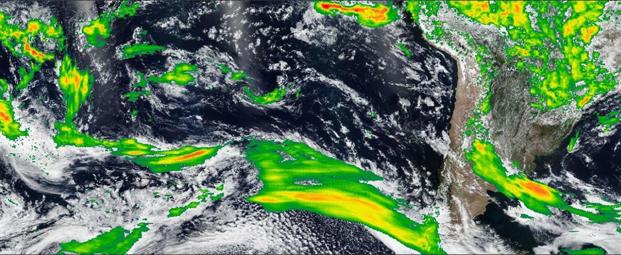
Polarized radio occultation (PRO) measurements have demonstrated the ability to characterize precipitation, detect rain and snowfall structure, identify melting layers, and observe variations in storm intensity. PlanetiQ uses a unique receiver to collect data with a high signal-to-noise ratio (SNR). High-SNR measurements are particularly important for precipitation applications because increased SNR improves sensitivity to lighter precipitation and certain cloud structures.
“By making polarized radio occultation data available through the CSDA program, NASA is enabling a broader research community to investigate new applications for these observations,” said E. Robert Kursinski, chief scientist, PlanetiQ. “As more researchers gain access to high-SNR PRO data, we expect both the scientific understanding and the potential operational uses of the technology for precipitation and severe weather monitoring to expand.”
PlanetiQ’s GNSS-PRO measurements are acquired using high-rate, high-SNR receivers that enhance the detection of precipitation signatures and cloud structures. In addition to supporting atmospheric science research, these measurements are critical for operational applications related to rainfall characterization, snowfall detection, storm monitoring, and weather forecasting.
Researchers interested in learning more about GNSS-PRO and precipitation sensing can watch PlanetiQ’s recent webinar.
PlanetiQ has been awarded a $15 million, 48-month Strategic Funding Increase (STRATFI) contract by the U.S. Air Force. The program will support the development and launch of spacecraft equipped with next-generation GNSS radio occultation (GNSS-RO) and GNSS polarimetric radio occultation (GNSS-PRO) instruments and the delivery of high-value weather data to the U.S. Air Force.
The mission will focus on advancing GNSS-RO, GNSS-PRO and GNSS reflectometry (GNSS-R) capabilities. The program includes the development of advanced data assimilation techniques to integrate enhanced GNSS-PRO data into numerical weather prediction (NWP) models, improving forecast accuracy and enabling new insights into atmospheric conditions.
After spacecraft commissioning, PlanetiQ will provide on-orbit data delivery during the contract period. This will support multiple applications across the Department of the Air Force, including artificial intelligence (AI) model training, data assimilation, and performance evaluation.
As the largest commercial provider of GNSS-RO data, PlanetiQ operates a global constellation of satellites, including spacecraft equipped with advanced receivers capable of capturing high signal-to-noise ratio (SNR) GNSS-RO and GNSS-PRO measurements. GNSS-PRO has demonstrated strong efficacy for measuring precipitation, a key capability for improving severe weather forecasting.
This STRATFI award will enable the development of a next-generation receiver that adds GNSS-R capabilities, supporting new applications such as ocean surface wind measurement, sea state characterization, and soil moisture monitoring over land.
“This award represents a major step forward in delivering more advanced, actionable weather information to the warfighter,” said Ira Scharf, CEO of PlanetiQ. “By combining GNSS-RO, PRO and R measurements in a single platform, we are unlocking a more complete picture of the atmosphere and Earth’s surface. We are proud to partner with the U.S. Air Force to accelerate these capabilities and bring next-generation environmental data into operational use.”
The NASA Goddard Earth Sciences Data and Information Services Center (GES DISC) and principal investigator Stephen Leroy of JANUS Research Group have released GNSS Radio Occultation (GNSS-RO) datasets.
The data release includes 72 different products from 15 different GNSS-RO receivers (or constellations of receivers) processed at four different GNSS-RO retrieval/processing centers. The data from different processing centers have been reformatted to have a common Climate and Forecast Metadata Conventions (CF) compliant format.
The algorithm was developed with funding from the NASA ACCESS 2019 program and the NASA Supplements for Open Science Support. These are the version 2.0 GNSS-RO products; version 1.1 is available through the AWS Registry of Open Data.
GNSS-RO data undergoes processing that is radically different from that of most atmospheric sounders, but it can still be categorized by its processing step:
uncalibrated data, as provided by the satellite instrument with communication information stripped, are Level 1a (not part of this release);
calibrated data, wherein the clock biases of the transmitters and receivers are removed and precise orbits determined are Level 1b;
extremely high vertical-resolution profiles of RO bending angle and microwave refractivity are Level 2a; and
profiles of temperature, pressure, and specific humidity on a coarser vertical grid are Level 2b.
Products are still being added to the archive. This initial release is complete for all processing levels of the COSMIC-1 data sets from four different processing centers. After all of the products in the initial release are complete for available data through July 2025, the project will bebegin forward processing for missions still actively producing data.
For more information about these products please see the README document and the Algorithm Theoretical Basis Document (ATBD).
PlanetiQ, a provider of commercial weather and space weather data, has been awarded a $24.3 million contract from NOAA’s National Environmental Satellite, Data, and Information Service (NESDIS). The award, issued under the Commercial Data Program’s Radio Occultation Data Buy 2 (RODB-2), is NOAA’s single largest commercial satellite weather data purchase.
Under the agreement, PlanetiQ will deliver 7,000 GNSS-RO profiles per day, including 500 enhanced high-signal-to-noise ratio (SNR) profiles as well as 2,500 low-latency Total Electron Content (TEC) tracks daily. Data deliveries began Sept. 18.
“I founded PlanetiQ because radio occultation is one of the few technologies I’ve worked with that tangibly improves the human condition. It’s gratifying to see this capability recognized and scaled.”
GNSS-RO data from PlanetiQ provides precise vertical profiles of the atmosphere across the globe, over land and sea, and in cloudy and clear conditions. It is recognized as the most impactful satellite data input for weather forecast models. GNSS-RO has become critical to space-based climate monitoring, improving and stabilizing weather prediction and atmospheric research over the past several decades.
The 500 enhanced high-SNR profiles per day are especially valuable in the lower troposphere, where measurement and forecast accuracy are often most challenging, further enabling actionable decisions and operations planning with reduced risk.
TEC data additionally strengthens NOAA’s space weather monitoring and forecasting capabilities.
“This award demonstrates NOAA’s confidence in our ability to deliver both the quantity and quality of data needed to advance weather and space weather forecasting,” said Ira Scharf, chief executive officer of PlanetiQ. “We are proud to expand our support for NOAA and its mission to protect life and property.”
The new contract represents a threefold increase in PlanetiQ’s data deliveries compared to its most recent NOAA award, which provided 2,200 profiles per day, and is adding the enhanced SNR and TEC tracks as new products. PlanetiQ collects thousands of profiles daily across the planet and plans to expand its constellation of satellites in the future.
PlanetiQ is excited that organizations running numerical weather prediction, and especially AI forecast models, are recognizing the value in high-quality GNSS-RO data. “Our ability to provide enhanced high-SNR profiles, at seven times the SNR of any other commercial company, sets us apart,” said Chris McCormick, president and chairman of PlanetiQ. “I founded PlanetiQ because radio occultation is one of the few technologies I’ve worked with that tangibly improves the human condition. It’s gratifying to see this capability recognized and scaled.”
While NOAA is the procuring agency of the GNSS-RO data, it will also be used by NASA, the U.S. Air Force, the U.S. Navy, and international government weather agencies for operational and research purposes.
This award underscores the critical role of public-private partnerships to bring new capabilities online faster and at a lower cost to strengthen national forecasting and research. PlanetiQ also partners with leading commercial technology companies and data providers.
Spire Global Inc., a global provider of space-based data, analytics and space services, was awarded a $11,190,900 contract from the National Oceanic and Atmospheric Administration (NOAA) to provide GNSS radio occultation (RO) data for a one-year period from Sept. 18, 2025, to Sept. 18, 2026.
The company’s near-real-time GNSS-RO data consists of vertical profiles of atmospheric measurements, including pressure, humidity and temperature, that can reach all points of the globe. NOAA, together with NASA, the U.S. Air Force and the U.S. Navy, will integrate Spire’s GNSS-RO data into their weather and space weather models, while additional U.S. and international agencies will leverage the data to strengthen forecasts and advance climate research.
“Spire’s satellites and radio occultation data are uniquely positioned to deliver the atmospheric insights needed to tackle today’s complex weather challenges,” said Theresa Condor, CEO at Spire Global. “Our continued work with NOAA underscores the importance of government–commercial partnerships in advancing weather forecasting and highlights NOAA’s commitment to harnessing innovation to improve forecasts and build climate resilience.”
The award is part of an Indefinite Delivery Indefinite Quantity (IDIQ) contract for NOAA’s Commercial Weather Data Program Radio Occultation Data Buy II.
PlantiQ — an atmospheric observing systems company — will begin daily delivery of its signal to noise ratio GNSS-radio occultation (RO) data to the National Oceanic Atmospheric Administration (NOAA) under the NOAA’s IDIQ-2 operational Delivery Order-2.
The NOAA has allocated $59.6 million over the next five years to use commercial satellite data to achieve high-quality weather forecasting and atmospheric research.
“By incorporating PlanetiQ’s commercial high quality GNSS-RO data, coupled with our deep understanding of RO technology, NOAA will have the information to significantly improve short and medium-range weather forecasts, and provide essential insights to enhance climate change research for the government, military and the private sector,” Ira Scharf, PlanetiQ CEO, said.
PlanetiQ supplies GNSS-RO data to NOAA from its growing constellation of satellites, which has become a critical part of the global observing system.
Conveners of a session on GNSS applications for water vapor observations are seeking research paper submissions. The session will take place during the Asia Oceania Geosciences Society (AOGS) Conference 2023 taking place July 30 to Aug. 4 in Singapore.
Session AG06 is titled “Assimilation of Space- and Ground-based Water Vapor Observations for Weather Forecasting and GNSS Applications.”
Observation of water vapor is one of the priorities in the Global Climate Observing System. Obtaining and exploiting additional high-quality humidity observations from GNSS and other remote sensing techniques is essential to improve weather forecasting and climate monitoring, the session conveners explained.
Abstract contributions are being sought on the topic, such as:
new algorithms to estimate water vapor from ground-based and space-based techniques, such as ground-based GNSS, space-based RO, InSAR, visible/near-infrared/infrared/microwave sensors and other sensors
retrieval and inter-comparison of water vapor among multiple instruments
assimilation and analysis of water vapor products from ground-based GNSS, space-based RO, InSAR, and various remote sensing/meteorological satellites for nowcasting and weather forecasting
use of numerical weather prediction models for modeling outputs as atmospheric corrections for GNSS, InSAR, VLBI and other geodetic observation techniques
estimation of atmospheric parameters from crowdsourcing equipment
atmospheric products for climate, hydrology, natural disasters and others.
CICERO-2 satellites will track Earth’s atmosphere, water, surface and interior
Remote sensing company GeoOptics Inc. has upgraded its CICERO constellation of satellites that measure the Earth’s climate. With launches beginning next year, CICERO-2 will form a unified Earth observatory allowing governments, industry and individual stakeholders to monitor and prepare for the impacts of climate change.
“In today’s environment, in which precision Earth sensing is becoming ever more critical, GeoOptics is deploying a flexible observatory made up of dozens of small satellites,” said Alex Saltman, Chief Executive Officer of GeoOptics. “The real time services will satisfy a broad range of needs for government and civil users around the world.”
The first CICERO-2 satellites launched are designed to achieve key milestones in small satellite Earth observation, including:
Advanced GNSS reflectometry (GNSS-R). Advanced GNSS-R measures many phenomena near Earth’s surface, including ocean winds, flooding, land cover (snow, ice, vegetation), soil moisture and topography by means of reflected GNSS signals. NASA’s recent CYGNSS mission demonstrated the broad utility of the GNSS-R technique. GeoOptics is working with NASA’s Jet Propulsion Laboratory (JPL) to deploy an advanced operational version, offering dramatically enhanced performance in a small, low-cost package. This collaboration is funded jointly by GeoOptics, the U.S. Air Force, and NASA.
Triple radio occultation (GNSS-RO). GNSS-RO enables Profiling of atmospheric temperature, pressure, density and other key properties. First proposed by company founder Tom Yunck while he was at JPL, GNSS-RO offers extreme measurement precision and is an essential contributor to global weather forecasting. The CICERO-2 satellites will yield three times the data volume of their predecessors and many times the volume.
Global precipitation watch. The CICERO-2 satellites will monitor heavy precipitation using polarimetric radio occultation (RO), an advanced remote sensing technique pioneered by GeoOptics’ collaborators at JPL and the Spanish PAZ mission.
Measuring weather changes
For GeoOptics’ strategic partner Climavision, a weather data provider, these innovations will enable customers to manage significant risks in a time of global change. “With these new developments in remote-sensing technologies from GeoOptics, we’ll be able to further enhance our climate and weather prediction capabilities,” said Chris Goode, CEO and co-founder of Climavision. “Through the combination of advanced RO profiles, GNSS-R data about surface conditions and our proprietary gap-filling radar network data, we’ll help customers in weather-sensitive industries see weather like never before and give them the tools and data to make informed critical decisions.”
GeoOptics will later extend the system to a range of new applications, including precise mapping of Earth’s gravitational field, which has been named a top NASA Earth science priority for the next decade. This measurement shows the imprint of climate-related movement of water and other key changes in the Earth.
With internal investment and nearly $4 million from NASA, GeoOptics has devised a unique system architecture for daily gravity mapping with clusters of small satellites. This patented technique promises to improve gravity sensing 20-fold over current methods at a fraction of the cost.
Under the umbrella of the National Oceanographic Partnership Program (NOPP), GeoOptics is also designing a radar instrument to observe ocean vector winds, topography, soil moisture and a variety of other surface properties with patented multi-satellite radar techniques. NOPP is seeking to sponsor a trial flight of GeoOptics’Cellular Ocean Altimetry/Scatterometry Technology (COAST) within the next two years.
Tom Yunck, GeoOptics’ Chief Technology Officer, said, “These advanced remote sensing applications – from basic RO to advanced radar and gravity mapping – exploit shared micro technologies that fit in the palm of one’s hand. Each new function builds naturally upon the previous, yielding prodigious observing capacity in a low-cost system of great simplicity and reliability.”
“CICERO-2 is designed to help provide high-priority NOAA climate and weather monitoring observations, as ranked by the NOAA Space Platform Requirements Working Group (SPRWG),” said Conrad C. Lautenbacher (Vice Admiral, USN ret.), executive chairman of GeoOptics and former National Oceanic and Atmospheric Administration (NOAA) administrator. “It can also play a key role in supporting crucial Defense Department satellite weather data requirements.”
GeoOptics’ CICERO satellites continue to provide precise global profiles of the Earth’s atmosphere. In February, NOAA selected GeoOptics to provide the first commercial satellite data to be included in its operational forecasts.
In 2020, GeoOptics was selected by NOAA to lead an end-to-end design study for its next-generation low-orbiting weather satellite system, planned to come online later this decade, building in part on RO and GNSS-R technologies.
Spire Global, a global provider of space-based data and analytics, has announced the continuation of its participation in NASA’s Commercial Smallsat Data Acquisition (CSDA) Program with a $6 million contract extension.
The contract continuation, Task Order 6 (TO6), is a subscription data solution that includes radio occultation (RO) data, grazing angle GNSS-RO, total electron content (TEC) data, precise orbit determination (POD) data, soil moisture and ocean surface wind speed GNSS-Reflectometry data and magnetometer data.
This data will be available to all federal agencies, NASA-funded researchers and, more broadly, to all U.S. government-funded researchers for scientific purposes.
Under CSDA Program TO6, Spire will deliver a comprehensive catalog of data, associated metadata and ancillary information from its Earth-orbiting small-satellite constellation. The company operates its constellation in low Earth and collects upwards of 10,000 radio occultations per day with consistent global coverage.
For TO6, Spire will provide rolling access to 12 months of radio occultation data with a 30-day latency. This data will be archived and maintained by NASA under the CSDA Program’s SmallSat Data Explorer (SDX) database.
“Programs like CSDA highlight the incredible potential of private-public partnerships in the federal government to drastically accelerate our ability to confront some of the greatest challenges of our time, such as climate change,” said Peter Platzer, CEO of Spire. “With the end-user license agreements, our data is now available to all federal agencies and the larger NASA scientific community to help support Earth observation research across fields.”
The program includes end-user license agreements (EULAs) to enable broad levels of dissemination and shareability. All federal agencies and U.S. government-funded researchers will have access to Spire’s data for scientific purposes under TO6 and will be able to request access to the data via the CSDA Program’s Commercial Datasets webpage.
“At NASA, the CSDA Program has continued to blossom as a valuable resource to our team for our Earth observation research and analysis. We are committed to growing the program as well as continuing the work we have started,” said Will McCarty, project scientist at the CSDA Program and research meteorologist at NASA Global Modeling and Assimilation Office. “Spire has been a valued partner through CSDA’s development since its inception, and with this additional task order, we are excited about the new insights and results that will come not only from within NASA, but also through broader collaboration through the domestic government scientific community.”
NASA has used Spire data in its research on water and sea-ice levels in the polar regions, the height of the planetary boundary layer (PBL), and the day-to-day variability of thermospheric density at flight level.
NASA also noted that Spire data has shown positive benefit to its GEOS Atmospheric Data Assimilation System, which uses space-based data to analyze the Earth’s atmosphere and assimilate the data into its Earth observation systems.
As one of the original vendors for the CSDA Program, Spire provides NASA yearly updates to the scope of work under this agreement to ensure alignment of data to the agency’s needs.
Spire Global, a global provider of space-based data and analytics, has announced the continuation of its participation in NASA’s Commercial Smallsat Data Acquisition (CSDA) Program with a $6 million contract extension.
The contract continuation, Task Order 6 (TO6), is a subscription data solution that includes radio occultation (RO) data, grazing angle GNSS-RO, total electron content (TEC) data, precise orbit determination (POD) data, soil moisture and ocean surface wind speed GNSS reflectometry (GNSS-R) data and magnetometer data.
This data will be available to all federal agencies, NASA-funded researchers and, more broadly, to all U.S. government-funded researchers for scientific purposes.
Under CSDA Program TO6, Spire will deliver a comprehensive catalog of data, associated metadata and ancillary information from its Earth-orbiting small-satellite constellation. The company operates its constellation in low Earth orbit and collects upwards of 10,000 radio occultations per day with consistent global coverage.
For TO6, Spire will provide rolling access to 12 months of radio occultation data with a 30-day latency. This data will be archived and maintained by NASA under the CSDA Program’s SmallSat Data Explorer (SDX) database.
“Programs like CSDA highlight the incredible potential of private-public partnerships in the federal government to drastically accelerate our ability to confront some of the greatest challenges of our time, such as climate change,” said Peter Platzer, CEO of Spire. “With the end-user license agreements, our data is now available to all federal agencies and the larger NASA scientific community to help support Earth observation research across fields.”
The program includes end-user license agreements (EULAs) to enable broad levels of dissemination and shareability. All federal agencies and U.S. government-funded researchers will have access to Spire’s data for scientific purposes under TO6 and will be able to request access to the data via the CSDA Program’s Commercial Datasets webpage.
“At NASA, the CSDA Program has continued to blossom as a valuable resource to our team for our Earth observation research and analysis. We are committed to growing the program as well as continuing the work we have started,” said Will McCarty, project scientist at the CSDA Program and research meteorologist at NASA Global Modeling and Assimilation Office. “Spire has been a valued partner through CSDA’s development since its inception, and with this additional task order, we are excited about the new insights and results that will come not only from within NASA, but also through broader collaboration through the domestic government scientific community.”
NASA has used Spire data in its research on water and sea-ice levels in the polar regions, the height of the planetary boundary layer (PBL), and the day-to-day variability of thermospheric density at flight level.
NASA also noted that Spire data has shown positive benefit to its GEOS Atmospheric Data Assimilation System, which uses space-based data to analyze the Earth’s atmosphere and assimilate the data into its Earth observation systems.
As one of the original vendors for the CSDA Program, Spire provides NASA yearly updates to the scope of work under this agreement to ensure alignment of data to the agency’s needs.
Parked cars near ground station decreased accuracy from 2 to 4 centimeters
A new study shows that the quality of GNSS reflectometry measurements may have improved significantly during the pandemic because of the lack of cars parked near the ground station, according to Science Daily. GNSS reflectometry is used for earthquake early warning systems, determining flood risks, and many other geodesy applications.
The study, carried out by geodesists from the University of Bonn, investigated the location of a precise GNSS antenna in Boston, Massachusetts.
GNSS reflectometry works well if the surrounding ground is flat, like the surface of a mirror, study author Jürgen Kusche explained to Science Daily. “But many GNSS receivers are mounted on buildings in cities or in industrial zones. They are often surrounded by large parking lots — as is the case with the antenna we investigated in Boston.”
The researchers show that parked cars significantly reduced the quality of the elevation data by scattering the GNSS signals, causing them to be reflected several times before they reached the antenna, like a cracked mirror. This reduces signal intensity and provides “noisy” data — hard to correct with pattern recognition because the parked cars change positions every day.
“Before the pandemic, measurements of antenna height had an average accuracy of about 4 centimeters due to the higher level of noise,” Makan Karegar told Science Daily. “During the lockdown, however, there were almost no vehicles parked in the vicinity of the antenna; this improved the accuracy to about 2 centimeters.”
While GNSS stations were historically installed in sparsely populated regions, recent installations have been in urban areas to support engineering and surveying work.
“Our study recommends that we should try to avoid installation of GNSS sensors next to parking lots,” Karegar said.
Citation. Makan A. Karegar, Jürgen Kusche. Imprints of COVID‐19 lockdown on GNSS observations: An initial demonstration using GNSS interferometric reflectometry. Geophysical Research Letters, 2020; DOI: 10.1029/2020GL089647
To get the best measurements of Earth’s atmosphere, you sometimes have to leave it. This November, the Sentinel-6 Michael Freilich spacecraft will do just that.
News from the Jet Propulsion Laboratory
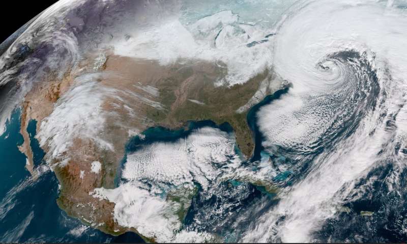
When a satellite by the name of Sentinel-6 Michael Freilich launches this November, its primary focus will be to monitor sea-level rise with extreme precision. But an instrument aboard the spacecraft will also provide atmospheric data that will improve weather forecasts, track hurricanes and bolster climate models.
“Our fundamental goal with Sentinel-6 is to measure the oceans, but the more value we can add, the better,” said Josh Willis, the mission’s project scientist at NASA’s Jet Propulsion Laboratory in Southern California. “It’s not every day that we get to launch a satellite, so collecting more useful data about our oceans and atmosphere is a bonus.”
A U.S.-European collaboration, Sentinel-6 Michael Freilich is one of two satellites that compose the Copernicus Sentinel-6/Jason-CS (Continuity of Service) mission. The satellite’s twin, Sentinel-6B, will launch in 2025 to take over for its predecessor. Together, the spacecraft will join TOPEX/Poseidon and the Jason series of satellites, which have been gathering precise sea-level measurements for nearly three decades. Once in orbit, each Sentinel-6 satellite will collect sea-level measurements down to the centimeter for 90% of the world’s oceans.
JPL-developed instrument
Meanwhile, they’ll also peer deep into Earth’s atmosphere with GNSS-RO to collect highly accurate global temperature and humidity information. Developed by JPL, the spacecraft’s GNSS-RO instrument tracks radio signals from navigation satellites to measure the physical properties of Earth’s atmosphere. As a radio signal passes through the atmosphere, it slows, its frequency changes, and its path bends. Called refraction, this effect can be used by scientists to measure minute changes in atmospheric physical properties, such as density, temperature, and moisture content.
The precise global atmospheric measurements made by Sentinel-6 Michael Freilich will complement atmospheric observations by other GNSS-RO instruments already in space. Specifically, the National Oceanic and Atmospheric Administration’s National Weather Service meteorologists will use insights from Sentinel 6’s GNSS-RO to improve weather forecasts.
Also, the GNSS-RO information will provide long-term data that can be used both to monitor how our atmosphere is changing and to refine models used for making projections of future climate. Data from this mission will help track the formation of hurricanes and support models to predict the direction storms may travel. The more data we gather about hurricane formation (and where a storm might make landfall), the better in terms of helping local efforts to mitigate damage and support evacuation plans.
The Sentinel-6 Michael Freilich spacecraft undergoes tests at its manufacturer Airbus in Friedrichshafen, Germany, in 2019. The white GNSS-RO instrument can be seen attached to the upper left portion of the front of the spacecraft. (Photo: Airbus)
A brief history of radio occultation
Radio occultation was first used by NASA’s Mariner 4 mission in 1965 when the spacecraft flew past Mars. As it passed behind the Red Planet from our perspective, scientists on Earth detected slight delays in its radio transmissions as they traveled through atmospheric gases. By measuring these radio signal delays, they were able to gain the first measurements of the Martian atmosphere and discover just how thin it was compared to Earth’s.
By the 1980s, scientists had started to measure the slight delays in radio signals from Earth-orbiting navigation satellites to better understand our planet’s atmosphere. Since then, many radio occultation instruments have been launched; Sentinel-6 Michael Freilich will join the six COSMIC-2 satellites as the most advanced GNSS-RO instruments among them.
“The Sentinel-6 instrument is essentially the same as COSMIC-2’s. Compared to other radio occultation instruments, they have higher measurement precision and greater atmospheric penetration depth,” said Chi Ao, the instrument scientist for GNSS-RO at JPL.
GNSS-RO basics
The GNSS-RO instrument’s receivers track navigation satellite radio signals as they dip below, or rise from, the horizon. They can detect these signals through the vertical extent of the atmosphere — through thick clouds — from the very top and almost all the way to the ground. This is important, because weather phenomena emerge from all layers of the atmosphere, not just from near Earth’s surface where we experience their effects.
“Tiny changes in the radio signal can be measured by the instrument, which relate to the density of the atmosphere,” said Ao. “We can then precisely determine the temperature, pressure, and humidity through the layers of the atmosphere, which give us incredible insights to our planet’s dynamic climate and weather.”
With the help of JPL’s GNSS-RO principal investigator Chi Ao and NOAA’s National Weather Service meteorologist Mark Jackson, this video explains how the GNSS-RO instrument aboard Sentinel-6 Michael Freilich will be used by meteorologists to improve weather forecasting predictions. (Credit: NASA/JPL-Caltech)
But there’s another reason why probing the entire vertical profile of the atmosphere from orbit is so important: accuracy. Meteorologists typically gather information from a variety of sources – from weather balloons to instruments aboard aircraft. But sometimes scientists need to compensate for biases in the data. For example, air temperature readings from a thermometer on an airplane can be skewed by heat radiating from parts of the aircraft.
GNSS-RO data is different. The instrument collects navigation satellite signals at the top of the atmosphere, in what is close to a vacuum. Although there are sources of error in every scientific measurement, at that altitude, there’s no refraction of the signal, which means there’s an almost bias-free baseline to which atmospheric measurements can be compared in order to minimize noise in data collection.
And as one of the most advanced GNSS radio occultation instruments in orbit, said Ao, it will also be one of the most accurate atmospheric thermometers in space.
More on the mission
Copernicus Sentinel-6/Jason-CS is being jointly developed by the European Space Agency (ESA), the European Organisation for the Exploitation of Meteorological Satellites (EUMETSAT), NASA, and the National Oceanic and Atmospheric Administration (NOAA), with funding support from the European Commission and support from France’s National Centre for Space Studies (CNES).
The first Sentinel-6/Jason-CS satellite that will launch was named after the former director of NASA’s Earth Science Division, Michael Freilich. It will follow the most recent U.S.-European sea-level observation satellite, Jason-3, which launched in 2016 and is currently providing data.
NASA’s contributions to the Sentinel-6/Jason-CS mission are three science instruments for each of the two Sentinel-6 satellites: the Advanced Microwave Radiometer, the GNSS-RO, and the Laser Retroreflector Array. NASA is also contributing launch services, ground systems supporting operation of the NASA science instruments, the science data processors for two of these instruments, and support for the international Ocean Surface Topography Science Team.