On June 26, the U.S. National Oceanic and Atmospheric Administration (NOAA) released the summary of the results of Commercial Weather Data Pilot (CWDP) Round 2. View the summary here.
In Round 2, NOAA evaluated GNSS radio occultation data from two U.S. commercial space companies: GeoOptics and Spire. NOAA concludes that, based on the results of CWDP Round 2, the commercial sector is able to provide radio occultation data that can support NOAA’s operational products and services.
“As a result, NOAA is proceeding with plans to acquire commercial RO data for operational use,” the summary states.
According to GeoOptics, the report highlights the unique qualities of its commercial GNSS-RO data and its ability to improve weather and space weather forecasts around the world.
“As today’s report demonstrates, commercial satellite data will enable NOAA to make significant improvements in forecasting worldwide within the consistent budget limitations under which it operates,” said GeoOptics CEO Conrad Lautenbacher.
NOAA anticipates release of a request for proposals soon for operational purchase of commercial radio occultation data, continuing an acquisition process that began in April with NOAA’s release of a draft Statement of Work.
NOAA has requested $15 million in FY 2021 to support Commercial Data Purchase. The FY 2021 Budget also requests $8 million for CWDP to investigate new commercial technologies beyond radio occultation.
By moving into this next phase of engagement with U.S. industry, NOAA is leveraging commercial space sector capabilities to support its operational products and services and to continue to improve its weather forecasting capabilities. NOAA plans to implement additional rounds of the CWDP to evaluate commercial capabilities beyond radio occultation data for potential operational use.
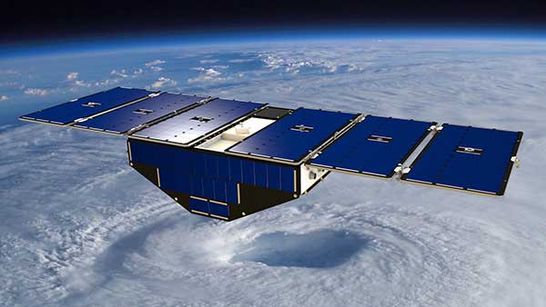
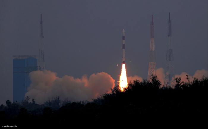
The COSMIC-1 program ended on May 1, when the last of six tiny satellites were decommissioned. The satellites were launched 14 years ago, and outlived their planned lifespan by 12 years.
COSMIC — the Constellation Observing System for Meteorology, Ionosphere and Climate (COSMIC) mission — uses GPS signals to provide a wealth of accurate atmospheric data and improve weather forecasts, according to Laura Snider, University Corporation for Atmospheric Research (UCAR), which ran the COSMIC program.
Meanwhile, the COSMIC-2 program (FORMOSAT-7 in Taiwan) continues. Its six satellites were launched on June 25, 2019, into low-inclination orbits. The mission was launched by NOAA as the agency’s first operational GNSS radio occultation mission.
COSMIC-1 demonstrated the value of GNSS radio occultation (GNSS-RO) to derive vertical atmospheric profiles of temperature, humidity and pressure by measuring the degree to which GPS signals bend as they travel through Earth’s atmosphere.
Weather centers used the high-quality, accurate data to improve forecasts; the data was also used by researchers.
“Throughout its lifetime, COSMIC-1 made an astounding 7 million vertical atmospheric profiles available to the operational forecast centers and research community,” writes Snider. “These data demonstrably boosted forecast accuracy and were referenced in more than 550 peer-reviewed scientific publications. In all, more than 5,000 users from over 100 countries have accessed COSMIC data.
COSMIC-1 was primarily funded by the National Space Organization in Taiwan, where the mission is called FORMOSAT-3. The leading U.S. sponsor on the project was the National Science Foundation. Other U.S. partners included NASA, the National Oceanic and Atmospheric Administration (NOAA), the Air Force and the Office of Naval Research.
UCAR also led the GPS/MET GPS radio occultation mission in the mid-1990s.
NASA is partnering with the New Zealand Ministry of Business, Innovation and Employment, New Zealand Space Agency, Air New Zealand and the University of Auckland to install next-generation GNSS reflectometry receivers on passenger aircraft to collect environmental science data over New Zealand.
The program is part of NASA’s Cyclone Global Navigation Satellite System (CYGNSS) mission, a constellation of eight small satellites launched in 2016 that use GPS satellite signals that reflect off Earth’s surface to collect science data.
The CYGNSS satellites orbit above the tropics and their primary mission is to use GPS signals to measure wind speed over the ocean by examining GPS signal reflections off choppy versus calm water. This allows researchers to gain new insight into wind speed over the ocean and will allow them to better understand hurricanes and tropical cyclones.
Measurements over land
In addition to its primary over-water research capabilities, scientists have discovered that the CYGNSS technology is also capable of collecting valuable measurements over land, including of soil moisture, flooding, and wetland and coastal environments.
“Partnering with New Zealand offers NASA and the CYGNSS team a unique opportunity to develop these secondary capabilities over land. Taken together over time, they’ll also have an important story to tell about the long-term impacts of climate change to these landscapes,” said Gail Skofronick-Jackson, CYGNSS program scientist at NASA Headquarters, Washington.
The CYGNSS team, led by principal investigator Chris Ruf at the University of Michigan in Ann Arbor, has developed a next-generation GNSS reflectivity receiver with support from NASA’s Earth Science Technology Office. These receivers will be installed in late 2020 on one of Air New Zealand’s Q300 domestic aircraft.
Artist’s concept of one of the eight CYGNSS satellites in orbit. (Image: NASA/University of Michigan)
Aircraft overlap satellite path
As the aircraft traverses New Zealand, it will collect data from the land below, some of which will overlap with the flight paths of the CYGNSS satellites.
This overlap, which will have frequent data observations from regular commercial flights, will provide the CYGNSS team a wealth of data to use to validate and improve the CYNGSS satellite observations, said Ruf.
In addition, the varied New Zealand terrain will provide comparison points with data collected in similar terrains in other parts of the world.
“As a result of this partnership, both Air New Zealand engineers and researchers across New Zealand will now have the opportunity to work with NASA on a world-leading environmental science mission,” said Peter Crabtree, general manager of Science, Innovation and International at New Zealand’s Ministry of Business, Innovation and Employment.
Science Payload Operation Centre
The University of Auckland will host the Science Payload Operation Centre, which will begin operations and data collection in late 2020.
“Over time, the data that will be collected by these receivers could form one of New Zealand’s largest bodies of long-term environmental data, and as such it represents a wide range of research opportunities,” said radar systems engineer and project lead Delwyn Moller of the University of Auckland.
Air New Zealand will be the first passenger airline to partner with NASA to collect data for a science mission. Air New Zealand has 23 Q300s in its fleet, and if the approach is successful, the airline will explore introducing the technology more widely.
An Air New Zealand Bombadier Q300. (Photo: Air New Zealand/NASA)
“As an airline, we’re already seeing the impact of climate change, with flights impacted by volatile weather and storms. Climate change is our biggest sustainability challenge, so it’s incredible we can use our daily operations to enable this world-leading science,” said Air New Zealand Chief Operational Integrity and Standards Officer Captain David Morgan.
The agreement will enable AER to process satellite data for commercial companies that sell their Earth observation data products to government agencies and other organizations that provide customized environmental information to a range of clients.
Under the agreement, AER will adapt UCAR’s SatDAACâ software system to process observations from satellites using GNSS radio occultation to observe the atmosphere. Those observations can lead to significantly improved weather forecasts.
From basic research to industry
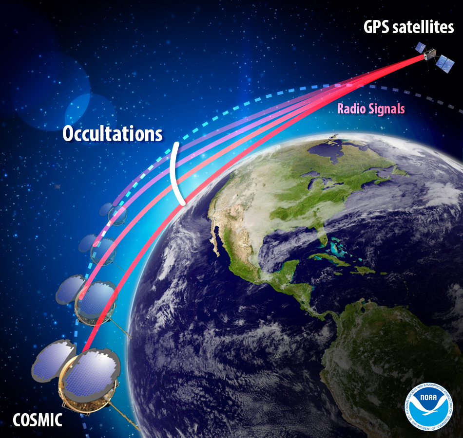
GNSS radio occultation measures the extent to which the radio signals from GNSS transmitter satellites (including GPS satellites) bend as they propagate through denser regions of the atmosphere.
The measurements can be further processed into information about temperature, pressure, and humidity in the lower atmosphere as well as the electron density in the ionosphere. The technique provides considerable accurate knowledge about a large volume of the atmosphere from near-Earth orbit down to the surface.
Image: NOAA
NASA’s Jet Propulsion Laboratory was first to use radio occultation to profile the atmospheres of Mars, Venus, and the outer planets starting in the 1960s. UCAR, in collaboration with JPL, pioneered the GNSS radio occultation observing technique for Earth’s atmosphere, building on basic research with funding from the National Science Foundation.
In 2006, UCAR began producing the first operational GNSS radio occultation data from a specialized constellation of small satellites known as the Constellation Observing System for Meteorology, Ionosphere, and Climate (COSMIC). The observations from COSMIC led to improved predictions of tropical cyclones and other storms as well as information about space weather and global climate.
A second constellation of small satellites, known as COSMIC-2, was launched in June 2019. It will provide twice as many soundings of the atmosphere with higher quality than COSMIC.
More GNSS-RO satellites coming
Now that the technology has been successfully demonstrated, additional satellites with GNSS radio occultation technology are being launched.
“This technology has moved quickly from being a research concept to providing vital information to forecasters,” said Ying-Hwa “Bill” Kuo. “The original investment in basic research is generating substantial benefits for society.”
Lead GNSS radio occultation researcher at AER Stephen Leroy said, “Earth radio occultation has a nearly 30-year history and has been a revolutionary force in numerical weather prediction and climate science in that time; and now with the commercialization of RO [radio occultation] data, we are looking forward to an explosion in RO data volume. I am really excited that we are performing the operational processing of this new data stream and expanding its scope and utility.”
The UCAR-AER agreement will likely lead to further advances in GNSS radio occultation technology, according to Bill Schreiner, director of the UCAR COSMIC Program.
“By transferring technology to the private sector, AER can take it to the next level in terms of distributing the data and finding new applications that help society,” he said. “This agreement will leverage SatDAAC’s advanced capabilities to develop new products for use by the environmental observing and prediction communities and will help us continue to innovate.”
At least three commercial enterprises are currently developing and deploying nanosatellites and microsatellites that perform GNSS radio occultation — Spire, GeoOptics and PlanetiQ — as well as several international space agencies.
AER works with governments and businesses worldwide to advance understanding of climate- and weather-related risks. The company develops analytical tools to help measure and observe the properties of the environment and translate those measurements into actionable information.
UCAR is a nonprofit consortium of 120 colleges and universities focused on research and training in the atmospheric and related sciences.
Your phone or satnav receiver routinely picks up signals from navigation satellites in order to tell you precisely where you are. But have you ever thought what happens to those satnav signals afterwards? A foresighted ESA inventor had the idea of using them as a tool for observing the Earth.
More than 120 satellite navigation satellites are in orbit, making up multiple constellations including Europe’s Galileo system, sending down a continuous rain of satnav signals for the benefit of users worldwide. Just like visible light, these microwave signals go on to reflect off Earth’s land and sea surfaces.
The traditional attitude to these reflected signals is to see them as something of a nuisance — known as multipath, they can confuse satnav receivers and reduce their overall accuracy.
ESA microwave engineer Manuel Martín-Neira, inventor of the PARIS reflectometry concept. (Photo: ESA)
But back in 1993 — at the same time as the US GPS satnav system reached its full constellation of 24 satellites — a young ESA microwave engineer called Manuel Martín-Neira came up with the idea of treating these satnav reflections as a scientific resource instead.
“My head of division asked me to come up with a budget-friendly way of increasing the overall sampling rate to build up a fuller picture of mesoscale phenomena, and that led me to start looking into making use of additional signals of opportunity, chiefly satnav signals.
“The initial reaction was mixed, because the forecast accuracy was not as precise as the ERS-1 altimeter could deliver — but on the plus side there would be a lot of these signals to make use of, and the performance has improved a lot since those early days.”
PARIS, detecting reflected satnav. (Photo: ESA)
Inspiration from reflection
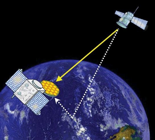
The basic idea of what Manuel christened the Passive Reflectometry and Interferometry System, or PARIS, comes down to a two-sided antenna. As the topmost side picks up a satnav signal from the satellites in orbit, the other side picks up the version of the signal bounced back from Earth.
By comparing this initial, overhead signal with its reflected equivalent using a process called interferometry — measuring tiny differences in signal phases – the extra travel time of this reflected beam can be determined, down to an accuracy of less than five centimetres, determining sea height and sea ice thickness.
Additional amplitude waveform processing can deliver further data on wind and wave measurements over the ocean, and soil moisture and biomass over land.
Satellite reflectometry has since grown into a thriving field. This summer, Manuel attended the latest international workshop on the method he first devised 26 years ago.
Reflectometry reaches space
“It’s been fantastic to have experimental evidence, and that’s really been made possible by the growing availability of smaller satellites,” explains Manuel.
“Because satellite reflectometry is a passive form of remote sensing, it makes for an attractive potential payload because it doesn’t need a lot of power to operate. Then one of the results is meteorology data that private companies intend to make money with by delivering to public agencies.”
Surrey Satellite Technology Ltd.’s UK-DMC satellite was the first orbital mission with a reflectometry payload. (Photo: ESA)
In 2003, the UK-DMC satellite was the first mission to fly a reflectometry payload, followed in recent years by, for example, the UK’s TechDemoSat-1, NASA’s CyGNSS constellation to monitor hurricanes and the Spire global constellation of commercial nanosatellites.
“These satellites have really given the reflectometry community a wealth of signals, demonstrating what reflections look like over different surfaces including sea ice, forests, and even inland water bodies such as the Amazon River and its tributaries.
“In parts of the ocean near continental masses and within atolls we are seeing reflected signals from very calm waters which resembled a mirror, giving us very high precision down to 1 cm level. Such measurements could potentially complement current altimetry missions, by for instance measuring sea level rise.”
Example of a CYGNSS Microsatellite Observatory. (Image: Southwest Research Institute)
ESA activities taking flight
ESA meanwhile is active on reflectometry in various ways, having developed and tested a steerable airborne antenna called the Software PARIS Interferometric Receiver or SPIR, capable of steering separate antenna beams to build up a rapid surface picture, and differentiating between different signal sources, such as GPS from Galileo.
Manuel adds: “ESA’s GNSS Science Support Centre, based at the Agency’s European Space Astronomy Centre near Madrid, has been taking a keen interest in these activities.”
Missions are also in development, including a dedicated CubeSat with RUAG-Austria and the University of Graz called PRETTY (for Passive REflecTomeTry and dosimetry, which would also carry a radiation detector), and a small satellite pair called FSSCat from Spain’s Universitat Politècnica de Catalunya, backed through the Copernicus Masters competition, seen as a prototype for a future reflectometry constellation.
ESA’s Directorate of Telecommunications and Integrated Applications is also working with the Spire company to fly enhanced reflectometry instruments, starting at the end of this year.
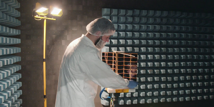
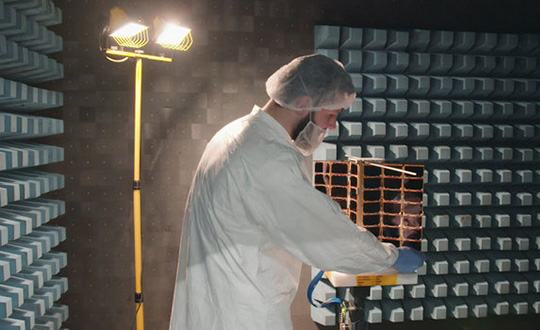
One of Spire’s Satellite Manufacturing Technicians (Tomasz Chanusiak) tests the Radio Frequency capabilities of a LEMUR2 nanosatellite in Spire’s cleanroom in Glasgow, Scotland. (Photo: ESA)
When it comes to the thriving state of today’s reflectometry community, Manuel recalls the patenting of his idea as a turning point: ‘Having had this idea, which was not particularly well received, the proposal by ESA’s Patents Group to patent it made all the difference. It gave me a feeling of confidence, that somebody else at least saw the potential of this idea — and the rest is history.”
Spire Global, a space-to-cloud analytics company, is now using Galileo to offer GNSS radio occultation (GNSS-RO) products for the weather community. Radio occultation is the process of using satellites to measure how GNSS signals are refracted by the Earth’s atmosphere.
Two of Spire’s nanosatellites are the first to use Galileo signals to measure GNSS-RO profiles, a service now available to Spire’s global user base as a new tier of data for advanced weather prediction. The satellites launched on Nov. 29, 2018, from Sriharikota, India.
The satellites are part of the collaborative European Space Agency ARTES Pioneer Space-as-a-Service program, which aims to prove the value of using nanosatellites for space-based GNSS-RO.
With Galileo, Spire’s weather observation satellites can harvest approximately 25 percent of the total GNSS-RO profiles available from the existing GNSS satellite constellations in orbit today.
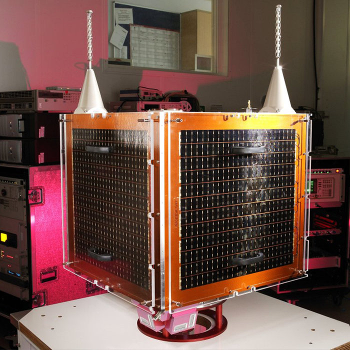
Spire operates 72 nanosatellites — also known as “cubesats” — and more than 30 ground stations throughout the world. The nanosatellites are developed, assembled and tested at Spire’s production facility in Glasgow, Scotland.
Two tiny GNSS-RO nanosatellites now circle the Earth, ready for action. The first European Pioneer mission lifted off Nov. 29 from Sriharikota, India, to put the satellites into orbit.
One of Spire’s Satellite Manufacturing Technicians (Tomasz Chanusiak) tests the Radio Frequency capabilities of a LEMUR2 nanosatellite in Spire’s cleanroom in Glasgow, Scotland. (Photo: ESA)
The shoebox-sized satellites were launched at 04:27 GMT into low Earth orbit by the Indian Space Research Organisation’s PLSV launcher, and opened their first communication windows with their owner, Spire Global, less than an hour after they separated from the rocket.
Both satellites were developed under ESA’s ARTES Pioneer programme, and will aim to prove the value of using nanosats for space-based GNSS Radio Occultation (GNSS-RO).
GNSS-RO. GNSS-RO is the process of using satellites to measure how GNSS signals are refracted by the Earth’s atmosphere. Experts can use these measurements to glean temperature, pressure and humidity information for weather forecasting and climate change monitoring.
In contrast, weather data gathered by weather balloons and aircraft can only reach certain altitudes, leaving the higher atmospheric layers untouched.
Satellites have no such restrictions. They can gather massive amounts of this data from the ground up to the mesosphere as they fly over the Earth. This is usually done by large satellites. Spire’s nanosatellites weigh just 5 kg each, and were assembled and tested entirely by Spire in under three months, at their headquarters in Glasgow, Scotland.
Named “Space as a Service,” the Spire Pioneer mission intends to prove that nanosat GNSS-RO is a commercially viable alternative to traditional methods.
Two nanosatellites built by Spire Global were launched into low Earth orbit Nov. 29. (Photo: ISRO)
The two tiny satellites will collect and distribute GNSS-RO data during their commissioning phase, after which they will go into full commercial data production mode, gathering weather information for meteorological institutions, maritime and aviation customers on demand.
ESA’s Pioneer initiative partners with companies like Spire to help them provide this kind of in-orbit demonstration and validation for third parties.
“We saw a gap in the market for what we call space mission providers: companies that offer all aspects of a space mission to validate a new technology or service for the benefit of others,” said ESA Pioneer Programme Manager Khalil Kably. “ESA is always looking to champion innovation in the space industry, and the idea of Pioneer is that these space mission providers can help this by being a one-stop shop for in-orbit demonstration and therefore reduce the barriers and complexity that can stifle new ideas.”
“Spire has been focused on developing unique data sources with high frequency updates for the entire Earth and has over 60 LEMUR-2 class satellites deployed in space complimented with a global ground station network,” Spire Global CEO Peter Platzer said. “Under Pioneer, we can offer our extensive experience in manufacturing and managing small spacecraft like these to those who cannot afford to waste money and time doing it themselves. This work with ESA helps further support the global development of commercial aerospace’s potential to make space access universal.”
“These incredibly clever shoebox-sized satellites built in Glasgow could slash the complexity and cost of access to space, presenting an exciting opportunity for the UK to thrive in the commercial space age,” UK Space Agency Chief Executive Graham Turnock said. “Through our £4m development funding, the government’s Industrial Strategy and by working closely with our international partners, we are helping UK businesses transform their ideas into commercial realities, resulting in jobs, growth and innovation.”
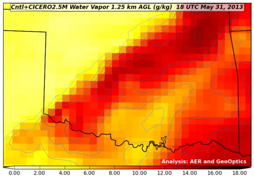
GeoOptics, a satellite-based environmental data services company, in cooperation with Atmospheric and Environmental Research (AER), an environmental research and development company, has announced the initial results of an Observing System Simulation Experiment (OSSE) showing the reliability of radio occultation data in improving predictions of severe weather and flash flood events.
Using weather prediction models and data assimilation techniques, AER evaluated the potential benefit of observing Earth’s atmosphere with a vast future constellation of many hundreds of orbiting GNSS – Radio Occultation (GNSS-RO) receivers. As a case study, the model used the convective system that brought severe weather to Oklahoma in 2013, which included an Enhanced Fujita Scale-3 tornado and heavy rains.
“The improved characterization of moisture in the lowest 4-5 km of the atmosphere is very significant and, working with our colleagues at AER, we believe quite a rigorous scientific conclusion,” said Conrad Lautenbacher, GeoOptics CEO. “We see commercial provision of GNSS-RO as a valuable complement to public sector systems and a reliable, low-cost way to achieve the levels of scale tested. We are very excited by the results.”
Through collaboration begun in 2014, the two companies set out to assess the impact of vastly increased numbers of GNSS-RO profiles on regional weather forecasting within the context of a global weather satellite system. Oklahoma was the region of focus of the study, an area with a history of severe weather phenomena. Today’s total global GNSS-RO profiles number approximately 1,800 per day, of which 0.64 profiles per day are readings taken over Oklahoma.
In the study, AER and GeoOptics modeled from 50,000 to 2,000,000 global profiles per day through the deployment of the planned CICERO satellite constellation. Such large scale would correspondingly increase the profiles per day over Oklahoma to between 17 and 700.
“We see commercial remote sensing and particularly the GNSS-RO technology as a paradigm change in developing and maintaining a cost-effective, next-generation operational observational infrastructure for environmental prediction,” said AER President Ron Isaacs. “The superb GNSS-RO technology knowledge base at GeoOptics provides an ideal and exciting complement to AER’s decades-long experience in today’s operational remote sensing and weather prediction practices, which include the current use of GNSS-RO sensing.”
GNSS-RO profiles provide measurements of atmospheric temperature, moisture, and pressure with a precision unrivaled by other space-based techniques. The RO sensor gathers this information by precisely observing perturbations imposed on ubiquitous GPS radio signals as they pass through the atmosphere. Today, nearly 3,000 organizations in more than 80 countries use RO data in Numerical Weather Prediction (NWP) and research. NOAA’s own studies show that more accurate mid- to long-term forecasts can be made up to 15 hours sooner using the data collected from the current limited set of experimental GPS-RO sensors.
GeoOptics plans to launch an array of powerful GNSS-RO sensors on its CICERO constellation of low-Earth-orbiting satellites. The rollout of the constellation will begin in the third quarter of 2015 and will deliver more than 50,000 global profiles per day when fully deployed. As demand grows, the 24-satellite CICERO constellation will be expanded to carry additional and complementary instruments, such as scatterometry and gravity sensors.
“GeoOptics will advance a small satellite observing model that starts with GPS radio occultation,” Lautenbacher added. “We believe an integrated private company like ours can deploy such systems for a fraction of current costs to the government.”
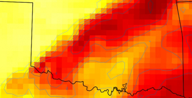
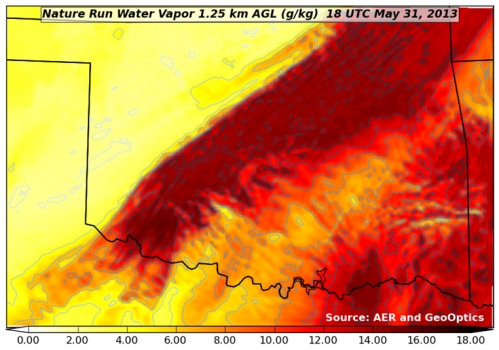
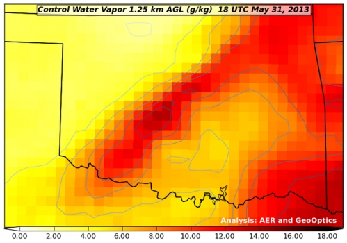
Figure 1. “Nature Run” (the truth reference) atmospheric water vapor at about 4,000 feet above the ground. The yellow-to-red color scale (bottom of figure) indicates how much water vapor is present, i.e., yellow is dry and red is moist. This realization of atmosphere moisture during an Oklahoma severe weather outbreak in May 2013 is the yardstick against which our assimilation experiments are compared for realism. It has a horizontal resolving power of about 1 1/4 mile (i.e., 2 km).Figure 2. Atmospheric water vapor analysis using conventional observing system. Valid time, vertical level and color scale are the same as in Figure 1. Note that the data fusion experiments use a bigger grid than the Nature Run (Figure 1) with a horizontal resolving power of about 11 miles (i.e., 18 km).Figure 3. Atmospheric water vapor analysis using conventional observing system + CICERO radio occultation observations. The distribution of water vapor in this analysis is much closer to the Nature Run (Fig. 1) in pattern and magnitude than the Control result (Fig. 2).