It said policymakers “could consider selecting the most resilient technologies as the cornerstone of the PNT suite for military missions, rather than defaulting to GPS.”
The 51-page report takes a comprehensive view of alternative PNT policy and leadership across the department. Its findings are an interesting and informative look at issues and efforts.
Increasing demands
The report comes at a time when U.S. forces have been seeing increasing interference with their own and allied GPS-enabled systems. The Organization for Security and Cooperation in Europe has regularly reported that its surveillance drones in the Ukraine have been jammed. Chinese press recently bragged that jamming caused U.S. Navy ships in the South China Sea to switch from using GPS to the Chinese BeiDou system. Additionally, U.S. military commanders have regularly described the Middle East as the most contested electronic warfare area on the planet, in large part because of regular interference with GPS signals.
The GAO study also comes on the heels of a provision in the National Defense Authorization Act (NDAA) for this year which directs DOD to provide non-GPS PNT to combatant commanders by 2023. The act says this timeline is consistent with responding to Joint Urgent Operational Needs, a formal method for commanders to communicate with department leadership. According to some sources, this suggests that the Pentagon has been receiving such requirements from field commanders, but has not responded to them in what Congress considers a timely manner.
Alternative PNT “not a priority,” resisted
Despite chronic GPS signal interference across the globe, outside experts and officials across the DOD told the GAO study team that developing alternative sources of PNT was not a priority for DOD. One example cited was the lack of a central program office.
One expert said, “PNT — It’s everyone’s need, but nobody’s business.” Another expert said, “Everyone wants to use [PNT], no one wants to pay or care for [PNT].” One DOD official characterized alternative PNT as an afterthought. DOD’s PNT Roadmap states that PNT capabilities, despite being mission critical, are not normally considered a key requirement, but rather may be treated as “a second-tier requirement.”
Worse, the report indicated that some forces within the department resist alternative PNT efforts.
According to one DOD official cited anonymously in the report “bureaucratic and political obstacles [represent] the biggest challenges for alternative PNT” and “anything that threatens GPS, such as alternative PNT technologies, faces pushback.”
The report cited another DOD official as agreeing that “there is an impression that the GPS program has a lot of political clout within DOD, and that those trying to develop alternative PNT technologies may face political challenges.”
Realistic requirements
Many missions do not need the accuracy provided by GPS, according to the report. Nevertheless. DOD programs often default to GPS performance standards when developing requirements. Many alternative technologies, while more resilient, are unable to achieve the same accuracy as GPS and therefore fail to meet the over-stated requirements.
Open architecture
Both DOD and GAO see development of modular open system architecture (MOSA) as key to PNT success in the future. This will allow addition of new PNT sources to a platform without the need for a major retrofit. With MOSA, all that would be needed is a new sensor module for the desired PNT source.
The GAO report endorsed this approach and encouraged DOD to institutionalize it with dedicated funding.
Working with industry
Decades of civil GPS use have benefited DOD in many ways. Broad academic and commercial research has resulted in a host of applications and improvements in the size, weight, and power requirements of equipment, as well as lowered costs. These benefits would almost certainly not have been realized at the current scale if the market for GPS equipment and apps had been restricted to military users.
The 2021 NDAA directs the department to “…enable civilian and commercial adoption…” of the GPS alternative technologies it develops for field commanders. The GAO report suggests DOD also work to leverage industry advances in technologies.
Scope and recommendations
GAO’s tasking for this effort did not include examining efforts to make GPS signals and equipment more resilient to disruption, nor use of non-U.S. satellite navigation systems. Neither were non-defense uses of PNT, nor improvements in such things as tactics, techniques, and procedures considered.
The study focused solely on department efforts to complement GPS services.
Six recommendations for policymakers are included in the report:
Increase Collaboration — Consider mechanisms to coordinate across DOD to clarify responsibilities and authorities in prioritizing the need for alternative PNT technologies.
Focus on Resiliency — Consider selecting the most resilient technologies as the cornerstone of the PNT suite for military missions, rather than defaulting to GPS.
Clarify Requirements — Consider opportunities to clarify what level of PNT performance is actually needed for missions, rather than defaulting to requirements that match GPS performance.
Coordinate with Industry — Consider ensuring that DOD and commercial industry coordinate so that industry is prepared to meet DOD’s needs, and DOD can leverage industry advances.
Institutionalize Open Architecture — Consider making the open architecture initiative more permanent, including providing funding.
Analyze Vulnerabilities — Consider having DOD conduct ongoing analysis of vulnerabilities of different PNT systems.
The May 2021 GAO report “Defense Navigation Capabilities: DOD is Developing Positioning, Navigation, and Timing Technologies to Complement GPS” is available here.
New technologies use a variety of inputs to help ensure seamless navigation, even when GPS reception fails because of interference or jamming.
Honeywell has successfully demonstrated multiple alternate navigation technologies for military aircraft. These new products are intended to help ensure seamless navigation — even when GPS signals are blocked, interrupted or unavailable.
For military operations, GPS-jamming — intentional or not — can block vital signals from conveying critical information regarding positioning, navigation and timing (PNT). In these instances, it’s important for military vehicles and aircraft to be equipped with alternative navigation technologies, like celestial or vision navigation, to maintain operational readiness.
“For military operations, not having access to critical positioning and timing information can make or break a mission,” said Matt Picchetti, vice president and general manager, Navigation & Sensors, Honeywell Aerospace. “We’re very excited to roll out this robust lineup of alternate navigation solutions, which are specifically designed to address the needs of our military customers and give them the added layers of redundancy needed to successfully carry out their operations, even if they lose access to GPS signals.”
Illustration: Honeywell
Alternate navigation technologies provide a different means of measuring position, velocity and heading when GPS is disrupted. These technologies include:
Vision-aided navigation. This technology uses a live optical or infrared camera feed and compares it with maps to provide a passive, not jammable, highly accurate alternative PNT solution that provides GPS-like accuracy in GPS-denied or jammed conditions.
Celestial-aided navigation. Honeywell’s celestial-aided navigation technology observes stars and “reference objects” orbiting the earth such as satellites, which have known positions and velocities. This technology compares those reference objects to stars and can determine position and velocity, the same way a GPS receiver can.
Magnetic anomaly-aided navigation. This navigation technology measures magnetic strength using sensors and compares this data with known geographical magnetic maps to accurately identify the position of the aircraft relative to the Earth.
Prototypes of these alternate navigation systems will be available in 2022, with initial deliveries expected to start in 2023.
Honeywell navigation systems are used by nearly every aircraft flying to guide millions of passengers to their destinations. Since 1914 when the first autopilot used Honeywell gyroscopes to hold the plane stable during flight, Honeywell has delivered more than 500,000 high-performance inertial sensors across several platforms on land, in the air and at sea.
Speakers include Diana Furchtgott-Roth Deputy Assistant Secretary for Research and Technology; ship captains from Maersk Lines; and representatives from the National Security Council, the Maritime Administration and U.S. Coast Guard.
While GPS jamming and spoofing is a problem in many transportation and critical infrastructure sectors, it is often most visible in maritime. This is because the Automatic Identification System (AIS) used for collision avoidance and traffic management for major vessels transmits location data based on GPS inputs.
These transmissions are received by coastal networks and satellite systems. AIS data is often freely available to the public or easily accessed.
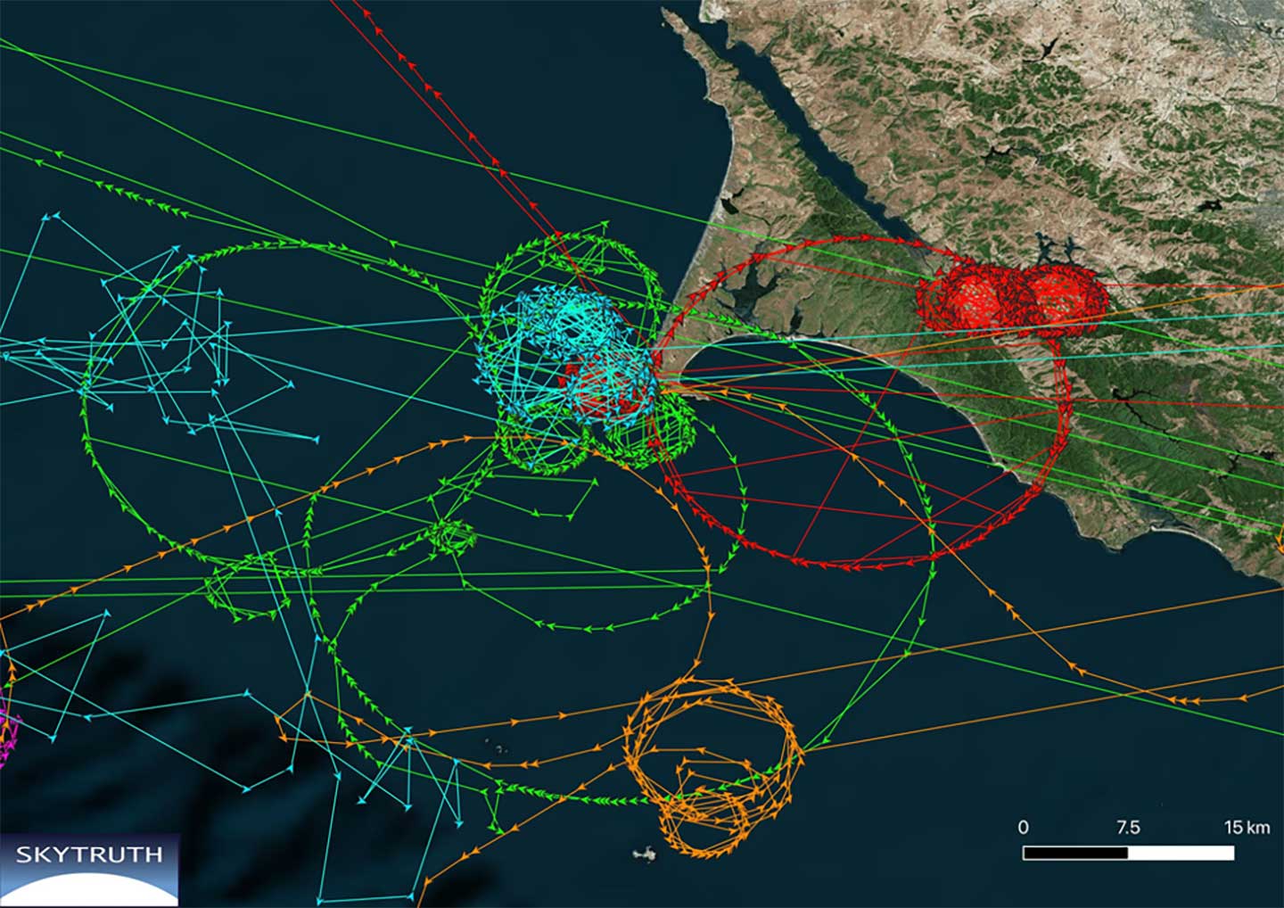
Ships in Russian waters being spoofed to inland airports, vessels in Chinese ports reporting they are inland and circling government buildings, and ships in one part of the world transmitting their location as thousands of miles away and circling in the ocean off northern California are three of the highest provide examples in recent years.
In 2019, the U.S. Coast Guard brought interference with GPS signals as an “urgent issue” to the International Maritime Organization.
In February, President Trump issued an Executive Order on responsible use of positioning, navigation and timing. This workshop is part of the federal government’s efforts, as a part of the order, to educate the public about vulnerabilities associated with over-reliance on GPA.
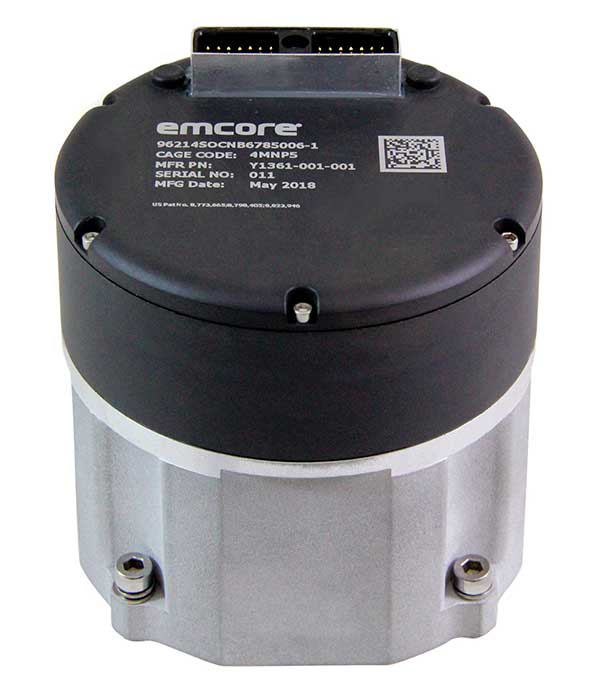
Emcore Corp.’s EN-300 FOG (fiber optic gyro) inertial measurement unit (IMU) is now in high-rate production and is broadly available for purchase with 12-week lead times. The EN-300 was announced in April.
Based in Alhambra, California, Emcore providees advanced mixed-signal products that serve the aerospace, defense and broadband communications markets.
Emcore’s EN-300 offers up to 10 times the bias performance of legacy systems in a form, fit and function compatible package, the company said. This improved performance makes the EN-300 suitable for GPS-denied navigation, precise targeting and line-of-sight stabilization requirements for unmanned aerial vehicles as well as other demanding applications.
Emcore has successfully completed a comprehensive Design Verification Testing (DVT) regimen over tough environmental conditions and has provided numerous proof-of-technology IMUs globally to defense contractor primes and aerospace customers seeking to upgrade their platforms and systems. Emcore is now expanding production of the EN-300 with strict manufacturing process and quality controls in place to enhance on-time delivery and specification compliance.
“Given the strong market interest and demand, we are extremely pleased to announce the production ramp-up and broad availability for purchase of the EN-300,” said David Hoyh, Emcore’s director of sales & marketing for navigation products. “Emcore’s vertical integration creates unique capabilities that enable us to deliver the higher level of performance demanded by the market, coupled with greater precision and lower cost to further benefit our customers.”
According to Emcore, the EN-300 precision FOG IMU is a three-axis, closed-loop design using the Company’s proprietary, solid-state FOG transceiver with advanced integrated optics, offering improved reliability and lower cost than legacy IMUs. It can be ordered with performance options tailored to specific customer requirements.
The COTS (commercial off-the-shelf) EN-300-3 model achieves bias in-run stability as low as 0.04 degree/hr with ARW (Angle Random Walk) of 0.015 degree/rt-hr. The non-ITAR EN-300 is superior in performance to older generation such as the closed-loop LN-200 IMU or open-loop KVH 1750 series IMU units that have higher bias over temperature drift.
The U.S. Army is opening a new office and laboratory to develop agile position, navigation and timing solutions to reduce soldiers’ dependence on GPS, according to reports in C4ISRNET and Defense News.
The new PNT modernization product office will focus on developing and deploying solutions that keep soldiers operating in areas where the GPS signal has been denied, degraded or spoofed. The office will open Oct. 8, and will use an open-systems architecture.
The new office will also host an Open Innovation Lab, a space where commercial entities can work with the Army to develop PNT solutions. Within lab, the Army has set aside space for the CMOSS (C4ISR/EW Modular Open Suite of Standards) Lab and the Network Cross-Functional Team’s Orion Forge at Aberdeen Proving Ground in Maryland.
The lab will be physically separated from the more classified areas of the site to encourage engagement with industry. Technologies to be explored include radio frequency systems, GPS, alt-nav, chip-scale atomic clocks, other timing technologies and celestial navigation.
According to the reports, the technologies will be fielded fast, with new solutions every five years. This is in contrast to the usual method of a decade spent developing technologies meant to last 20 years so that soldiers can always combat adversaries’ capabilities.
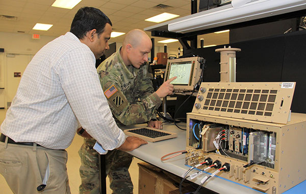
Andradige Silva, electronics engineer for the C5ISR Center’s Intelligence and Information Warfare Directorate, and Maj. Doug Williams, assistant product manager for the Joint Battle Command-Platform, access the C4ISR/Electronic Warfare Modular Open Suite of Standards (CMOSS). (Photo: U.S. Army)
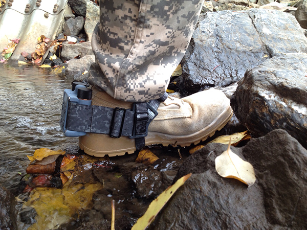
A new system, called WarLoc, makes it possible to locate warfighters and first responders in GPS-denied environments.
Created by Robotic Research, a manufacturer of autonomy and robotic technology, the system provides localization and positioning data for teams entering underground facilities and traveling inside buildings and in urban canyons.
According to the company, multiple systems — including, besides WarLoc, robotic systems, UAVs and manned vehicles equipped with its technology — collaborate to enhance accuracy and maintain the localization of teams.
Its system, the company said, is unique in that “it has very small 3D position error in such a small package” and its filtering algorithms, rather than being centralized, are “distributed and opportunistic in nature to provide the best solution given the communications available.”
In January, Robotic Research received a $16.5-million order for WarLoc from the U.S. Army Product Manager Sets, Kits, Outfits and Tools (PM SKOT) to support forward-deployed U.S. military personnel. The company will deliver the WarLoc units to equip four deployed U.S. Army Brigade Combat Teams. The first batch has been shipped. The procuring organization, PM SKOT, provides Army and Joint Services oversight of the lifecycle for all sets, kits, outfits and tools used by U.S. soldiers.
Distributed System
A self-contained localization system typically relies on GNSS signals, when available, complemented by inertial navigation. By contrast, the WarLoc is a distributed system meant to work as a team, said Alberto Lacaze, Robotic Research’s co-founder and president. The problem, he explains, is how to filter these devices. Centralized approaches, in which every device sends its information to a central computer that does all the filtering, “work very well for an incident commander with a group of first responders going into a building, where the distances are relatively small.” However, he pointed out, they do not work when communications go down.
The alternative approach is to filter the information opportunistically, in a distributed fashion, which is what WarLoc does. In GPS-denied environments, “there is a process that synchronizes all the nodes once the communications have been established,” Lacaze said. “However, if you have, for example, two team members that are each in their own radio bubble, their solutions will continue to be optimized and other team members might be in their own bubbles, so their solution is also being optimized. If these two teams get in contact, their information will get synchronized and collectively optimized.”
The system, he adds, is “heavily reliant on the inertial solution and dead reckoning.” The more units can communicate and share data, the more accurate the navigation solution is. “In a relatively small package, we can achieve better than 1% error of distance traveled for a single unit,” said Lacaze. “Once you have multiple units communicating and measuring with each other, the solution gets significantly better.”
WarLoc, which contains all the required hardware and software, connects to a system used by first responders and the Department of Defense’s Android Tactical Assault Kit (ATAK) also being used in GPS-enabled areas. “Our system can be used not only for tracking humans, but also for tracking animals and other devices, such as robotic systems or vehicles,” Lacaze said.
Relative Localization
On the commercial side, the company has created a kit for autonomous shuttles and is deploying it in about 20 cities around the world. Like WarLoc, this device also works in GPS-denied areas, such as on an underground shuttle on a university campus. “We just won a contract to automate the busses that go through the Lincoln Tunnel,” Lacaze said.
Busses or shuttles using Robotic Research’s system “learn landmarks in the area that they are traversing and use them as an aid in localization, in conjunction with inertial units,” Lacaze said. “The vehicles learn their surroundings.” They don’t care about their absolute position, he explained, only about their relative position with respect to those areas. This is similar to pre-GPS directions like “Make a left at the post office, then a right at the gas station.” They can also use a common landmark. “If the first vehicle is seeing a certain building and knows its lat/long and the second vehicle saw that building some time ago, it can measure its distance from it using its own inertial system.”
While warfighters communicate their position information via their personal tactical radios to ATAK, which then shares it through its current radio infrastructure, vehicles on the road communicate it through dedicated short-range communications (DSRC) radio, a cell network, or some other network.
Other Robotic Research Programs
Robotic Research’s technology supports a range of robotics and autonomous vehicles in GPS-denied environments, including shuttles and buses for public transportation, hybrid unmanned aerial and ground vehicles (UAVs and UGVs), and trucks in the U.S. Army Autonomous Ground Resupply (AGR) Expedient Leader-Follower program.
The company is the prime contractor on several Army programs, including AGR, which consists of robotic trucks that the Army will begin to deploy. “We have delivered close to 100 of those trucks,” said Lacaze. “So, for example, if you are in a convoy and you need to know whether your warfighters are inside or outside a truck, WarLoc can tell you.”
Robotic Research’s AutoDrive autonomy kit, which can be retrofitted to vehicles of all sizes, provides autonomous functionality on surfaces ranging from urban-improved roads to off-road terrain, while the vehicle collects and analyzes data. The technology provides automation to one of the largest international shuttle providers as well as to the largest U.S. manufacturer of commercial buses, according to the company.
In February, the company announced it will begin testing totally unmanned, fully autonomous, low-speed shuttles in the second quarter of this year. It will initially involve attendants in fixed on-site locations, then will aim to move attendants to an offsite safety-monitoring facility.
GPS signals are by far the single most widely used and most accurate source of navigation, positioning and timing (PNT), and this capability is deeply integrated into every aspect of our society. In particular, the timing service provided by GPS, while virtually unknown to the general public, is essential for a variety of digital operations — from performing financial transactions to operating cell phone networks to running the internet.
Of course, GPS — originally developed to guide nuclear submarines — is now vital to most military missions, and the system’s vulnerabilities are a source of great concern.
GPS has been remarkably reliable over the past quarter century. Solar flares are rare, multipath can be largely mitigated, and obstructed line-of-sight to the satellites is an acute problem only in certain environments, such as urban canyons.
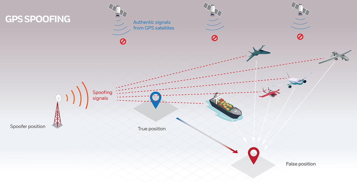
The most serious intentional threats to GPS are spoofing and jamming. Jamming is more widespread — it is more easily accomplished intentionally and it also occurs unintentionally. In the defense sphere, intentional jamming is a regular occurrence. It is expected as a routine aspect of electronic warfare operations to disrupt and deceive, typically just before the shooting begins. Unintentional jamming includes recently re-emerging concern about potential interference by ultra-wideband devices.
Experts at NovAtel, Collins Aerospace, L3Harris Technologies and Honeywell address the challenges posed by jamming and the relative effectiveness of various anti-jamming approaches.
NovAtel
Tackling Jamming on Multiple Levels
Disruption by jamming of GPS’s PNT data “is occurring with a growing regularity,” said Dean Kemp, Defense Segment manager at NovAtel, part of Hexagon’s Positioning Intelligence division. The problem will only increase, given our reliance on GNSS and increasing demand for precision. In the military sphere, electronic warfare in Syria, as well as jamming in Ukraine, Korea, and Finland, “have shown that modern, high-power equipment is routinely being used to disrupt the military.”
In the civilian sphere, interference is a growing issue because of cheap and effective jammers available via the internet. People use these so-called personal privacy devices to defeat vehicle tracking devices for purposes ranging from avoiding supervision all the way to hijacking vehicles.
GNSS signals are vulnerable because the received power is so small that receivers can be disabled with an incident power in the picowatt (10-12 W) range. “Jammers come in many different forms,” Kemp said, “from low-power civil devices to complex and powerful military-grade electronic warfare systems that can disable civilian receivers from a few hundred meters to hundreds of kilometers.”
Situational Awareness. Users can fail to recognize that their GPS is being jammed, Kemp said. Beyond defending against possible jamming scenarios, it is also necessary to “identify, find, and characterize the source of interference and to provide this information to the user so that it can be used appropriately.” In the defense field, this is known as situational awareness.
Emerging jamming threats, Kemp explained, can be understood within the context of cyber and information warfare using the Cyber Electromagnetic Activities (CEMA) layered approach. It recognizes a cognitive layer — a human decision based on PNT data; a virtual layer, in which PNT data are used to inform or support networked systems; and a physical layer, the hardware used to provide and protect PNT data.
Therefore, effective anti-jamming requires that:
users understand the system’s vulnerabilities and identify when they are being jammed, so that they can resort to traditional means for positioning and navigation (but not timing)
PNT data be protected and verified before being trusted
on the physical level, there be a multi-layered and heterogeneous approach that provides assured PNT information in the presence of jamming and spoofing without quantifiable loss of accuracy.
By combining these considerations at each layer, “they form a unified view on capability,” Kemp said.
Spoofing with Pokémon. Jamming threats are evolving, employed by both civilian and state actors. Worse, these threats are augmented by spoofing. While spoofing is harder to achieve than jamming, it is potentially more concerning. “Spoofing the receiver by rebroadcasting the GNSS signals or by generating them from a simulator has become a regular occurrence,” Kemp said.
Spoofing came to public attention in 2016 when enterprising programmers designed location-deception apps to hack the Pokémon Go mobile game. Instances have since been reported worldwide. Because early spoofing demonstrations were conducted against simple GPS L1 C/A-code receivers, it was initially hoped that spoofing could be defeated by using dual- or multi-frequency receivers.
However, it has been demonstrated that multi-frequency receivers using commercially available components can also be spoofed, “at least when the receiver is using multiple frequencies of GPS,” Kemp noted. “Adding further GNSS signals will help, but the best defensive measure is to employ, if authorized, an encrypted military signal.”
Coverage Improvement Factor. Typically, the effectiveness of an anti-jam system is assessed on the basis of the jamming to signal ratio (J/S) figure in decibels, which depends on variables such as the receiver’s front-end RF bandwidth, the signal type being tracked (C/A versus P(Y) code), the signal tracking threshold of the receiver, the receiver platform dynamics, the choice of receiver oscillator, the interference type and antenna characteristics.
Difference in how manufacturers calculate J/S led to the invention of the coverage improvement factor (CIF), adopted by the GPS Joint Project Office. “CIF gives a single number that describes the effectiveness of an anti-jam system for a particular jammer scenario, given that space vehicle positions vary by elevation and azimuth,” Kemp said.
However, the use of CIF to assess the anti-jam performance is a highly technical process and the results are usually classified. He discussed current approaches to anti-jamming.
Multi-element, controlled reception pattern antennas (CRPA), which pass the good signal to the receiver while nulling out the interference, are the first line of defense. “The system can dynamically change the gain pattern of the antenna so that as the platform and jammers move, the gain pattern adapts so that nulling continues effectively.”
The use of multiple constellations and frequencies can be an effective tactic to mitigate interference, “but relies on the jammer not covering the bands of interest.”
“Obtaining actionable data on interference is almost as important as mitigation,” because it enables users to modify plans. However, “interference effects can be difficult to diagnose and complicated to track down.”
Monitoring automatic gain control can indicate jamming.
“Coupling a GNSS receiver with a robust inertial measurement unit (IMU) will provide a higher level of protection for GNSS signals due to the IMU providing reliable position, velocity and attitude even through short periods when satellite signals are blocked or unavailable.” However, IMUs are liable to drift, resulting in degraded performance.
There are many approaches to designing anti-jam systems. They must be balanced against user requirements, which vary significantly. “A layered approach is the best form of defense against jamming and spoofing,” Kemp said, starting with protecting the incoming GPS signal. “One of the highest levels of protection is from an anti-jam antenna system paired with a GNSS receiver that is tightly coupled with an IMU.”
Finally, given that jamming attacks are now to be expected on the battlefield, it is critical to train users on the best response.
Collins Aerospace
Artist’s concept: Collins Aerospace
A Potent Triumvirate of Tools
While sources of deliberate jamming are on the rise, the vast adoption of GPS means that “even the non-deliberate sources of jamming will have an asymmetric impact on end users,” said Sai Kalyanaraman, Ph.D. and Technical Fellow at Collins Aerospace. Challenges posed by jamming depend on the receiver, mission and performance needs, while the source of unintentional jamming could be “something as simple as a TV antenna that is transmitting harmonics into the GNSS band.”
Kalyanaraman outlined viable approaches to interference mitigation and anti-jamming:
Integration with inertial navigation systems (INS) can provide the platform’s attitude, which is required for beam forming. This, in turn, is required for some of the CRPA GNSS Anti-jam signal processing modes. It can also alert the user of jamming when the INS position diverges dramatically from that provided by the GPS receiver.
Use of multiple frequencies is a form of robust design against interference.
For authorized users, M-code will provide additional limited capabilities against jammers.
Integration of GNSS with other PNT sensors to help address GNSS-denied environments.
GNSS signals have the advantage that the true signal is well under the noise floor; therefore, “as long as you can characterize the noise floor adequately from the receiver design/installation perspective, anything that shows up above the noise floor typically does not belong in that slice of the spectrum,” Kalyanaraman said. Combining a CRPA, a platform orientation sensor (like an INS), and a GPS/GNSS receiver, “you have a fairly potent triumvirate of tools that you can use to help mitigate the impacts of jamming and potentially spoofing.”
Collins produces multiple variants of its digital integrated GPS anti-jam receivers (DIGAR). “Depending on which variety you choose, you can essentially have a receive apparatus that can perform basic nulling all the way up to beam-forming and direction finding and help provide resiliency against high jamming signal levels and other threats that emulate a GNSS-like signal in space,” Kalyanaraman said.
L3Harris
L3Harris develops gun-hardened anti-jam solutions for the M1156 Precision Guidance Kit Modernization program. The kit turns 155-mm artillery shells into smart weapons. Here, soldiers test the kit for accuracy. (Credit: U.S. Army/Spc. Robert Porter)
Field Tests Verify PNT Reliability
Dealing with deliberate and unintentional interference with GPS requires agreeing on the level of enhancements required, reducing the time and cost needed to integrate them into systems of systems, and “centralizing PNT generation and distribution functions on a platform to reduce user equipment redundancies and increase the leverage of future PNT enhancements,” said Dave Duggan, president of the Precision Engagement Sector at L3Harris Technologies.
The increase in interference “creates a cascading negative effect to PNT client mission systems,” Duggan said, including the systems of systems for sensing, maneuver and fires [military-speak for the use of weapon systems].” The capability of anti-jam countermeasures “scales across a range of performance, size, weight, power and cost points and can be tailored to a given threat space, improving the performance of even legacy user equipment.”
Spoofing, which inhibits receivers from forming a solution or, worse, tricks them into passing misleading PNT solutions to other systems, is a bigger challenge than jamming because it can result in aborted missions and loss of life and usually requires new receivers, Duggan said.
Duggan defines a reliable anti-jam/anti-spoof capability as one that “provides a PNT solution with a high level of confidence in its accuracy, authenticity and integrity for their applications and anticipated threat environments — all at a reasonable cost/performance point.” Confidence in the solution requires “extensive analysis, threat modeling, simulation and testing of the anti-jam/anti-spoof capability.” For this reason, “L3Harris has worked extensively in developing simulation and testing environments of the highest fidelity and continues to participate in numerous live field test events to establish that foundation.”
L3Harris develops and produces digital anti-jam antenna electronics for U.S. and allied end use.
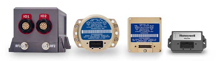
Honeywell
Honewell’s HGuide micro-electro-mechanical system (MEMS) inertial measurement units (IMUs) and INS are designed to be integrated with GNSS receivers. (Photo: Honeywell)
Integrating GNSS with Inertial
Heightened awareness of intentional and inadvertent jamming threats has less to do with new types of threats and more to do with the increased importance of precise PNT coupled with more frequent instances of jamming, according to Chris Lund, senior director, HGuide Navigation and Sensors at Honeywell Aerospace.
“As applications become more reliant on highly accurate and reliable position and timing information provided by navigation systems, the consequences associated with the data not being available or not being correct quickly escalate,” Lund said.
The best way to measure the impact of a jamming threat and the capabilities of countermeasures is “to determine in actual real-world use cases whether the desired application outcome can still successfully be achieved,” Lund said.
The most promising approach to anti-jamming is integration of GNSS receivers with inertial navigation systems (INS) and other PNT systems. “Given the complementary aspects of many of the available approaches in the anti-jamming toolkit, it’s often best to leverage however many tools are available and needed to allow the application to achieve its desired outcome,” Lund said.
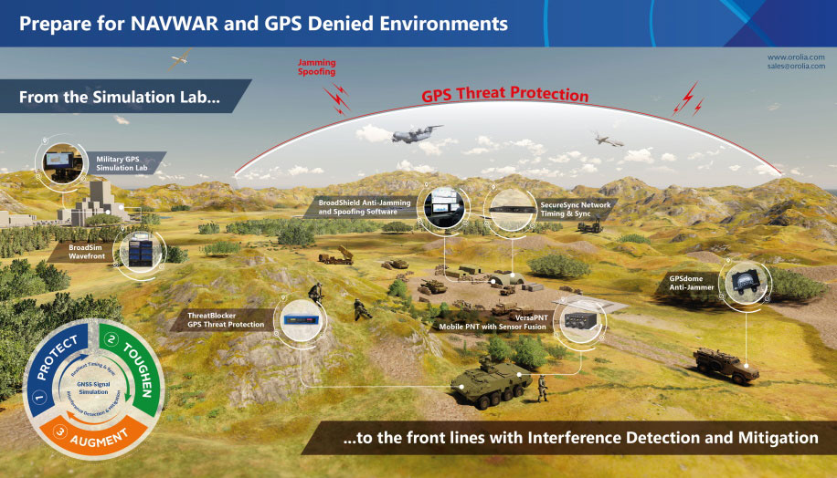
Resilient positioning, navigation and timing (PNT) company Orolia has nearly tripled new U.S. military orders for specialized resilient PNT solutions in the third quarter of 2019, the company stated in a press release.
Orolia said its solutions are helping to meet growing military demand for assured operations in Navigation Warfare (NAVWAR) and GPS-denied environments.
In the third quarter, Orolia unveiled its new Simulation and Interference, Detection & Mitigation (IDM) suite, announced the acquisition of GNSS simulation company Talen-X and introduced new advanced GNSS jamming and spoofing countermeasures.
The new U.S. military orders include the full range of Orolia’s resilient PNT solutions.
“This rapid industry response affirms Orolia’s commitment to delivering trusted military solutions for GPS denied environments,” said Paul Zweers, Orolia vice president of sales and marketing.
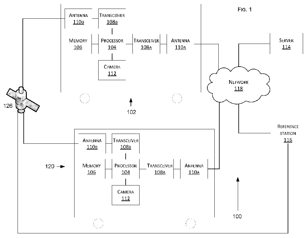
Tesla has developed a technology aimed at providing more accurate positioning for autonomous cars by sharing data between vehicles, according to a U.S. patent application.
The patent, “Technologies for vehicle positioning,” was filed in 2017 and made public in December 2018.
Solutions include cameras detecting matching locations and using other vehicles in its fleet as “cooperative reference stations” to share raw GNSS data and make positioning corrections.
Tesla describes in the patent, “The inventions increase such positioning accuracy via determining and applying offsets (corrections) in various ways, or via sharing of raw positioning data between a plurality of devices, where at least one knows its location sufficiently accurately, for use in differential algorithms.”
Techniques include:
a reference station sharing a positional offset with an automobile,
a reference station calculating and sharing a set of parameters (offsets and corrections) for various error components including atmospheric, orbital and clock,
a reference station sharing its raw GNSS data so that vehicles can remove errors through differencing or other calculations.
Tesla also would correct GPS data by matching camera data with vision maps to detect the exact location of a vehicle. With this vision-map matching localization approach, “a location estimate is varied until the location estimate makes a camera-reported lane boundary coincide with a map-reported lane boundaries,” the patent reads.
Schematic of Tesla’s system shows two vehicles (102, 120) feeding data to a network, a server and a reference station. (Image: Tesla)
InvenSense (TDK Corporation) has introduced a line of automotive high-accuracy devices: the IAM-20680, IAM-20680HP, IAM-20380 and IAM-20381.
According to the company, they are designed to enhance the absolute position of a vehicle in GNSS- and GPS-denied environments.
The IAM-20680 is a 6-axis qualified sensor that features 16-bit accelerometers and 16-bit gyroscopes.
The IAM-20680HP is a high-performance version of the IAM-20680 that features high gyroscope and offset thermal stability.
The IAM-20380 gyroscope is compatible with a 3-axis automotive accelerometer and an automotive-qualified 6-axis device.
The IAM-20381 is a 3-axis accelerometer compatible with a 3-axis automotive gyroscope and an automotive-qualified 6-axis device.
The IAM-20680HP and IAM-20680 can be used to improve estimates of position, direction and speed when GNSS is denied, as well as improve quality of the position estimation when the satellite signal is strong.
Customers can design with the IAM-20680 and can use the IAM-20680HP when navigating in high temperature environments or for systems where cooling is weak or unavailable.
The U.S. Army is drafting new rules for the use of GPS receivers in weapon systems to combat spoofing and jamming attacks, as well as signal loss in GPS-denied environments, according to news reports.
The six- to seven-page capabilities requirements document is awaiting a signature from Army leadership, according to Willie Nelson, director of the assured PNT (positioning, navigation and timing) cross-functional team. Nelson spoke to reporters Oct. 9 at the Association of the U.S. Army annual meeting in Washington, D.C.
The Army has been trying for years to complete a GPS requirements document, a “system of systems architecture for assured PNT.” But with virtually every device equipped with GPS, the document would have been too big and too broad, Nelson said.
(Photo: U.S. Army)
The approach now is for separate sets of requirements: one for mounted equipment (now complete and awaiting the signature), a dismounted requirement, and situational awareness.
The difficulty facing the Army is the plethora of PNT systems in use. For instance, an armored personnel carrier may have five to seven unconnected GPS receivers, some with encryption, some without. The weakest receiver could negatively affect the vehicle, Nelson said.
With the new requirements, Army vehicles will have a consolidated, networked, software-based PNT solution. Dismounted receivers used by soldiers will have similar requirements.
Industry will be asked for specific solutions within each of the PNT sectors rather than an “all of the above” solution.
The Army is also expected to create a training program for soldiers that operate PNT systems.
U.S. Department of Defense interference events, designed for training in GPS-denied environments, also can affect civilian aircraft.
In April 2016, a business jet lost all GPS signals because of an interference event and was forced to enter a Dutch Roll, resulting in an emergency descent.
Pilots and air traffic controllers in the National Airspace System want to better understand the operational impacts of the intentional interference, which has risen from 43 in 2012 to 127 in 2017.
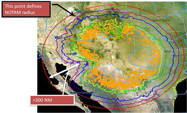
Interference Contours from the YPG 17-02 GPS interference event in January 2017. (Source: FAA)
An RTCA Tactical Operations Committee composed of Federal Aviation Administration (FAA) and industry experts in March issued a report with recommendations to change the current Notices to Airmen (NOTAMs).
Along with a description of the event, NOTAMs show contours that represent an area outside of which operators should expect no interference impact. Both operators and the FAA agree that most aircraft experience no interference impact even inside the contours.
Operators recommend that the FAA provide pilots and controllers improved understanding of where to expect interference impacts based on different equipment capabilities, so that operators could integrate such information in their flight planning processes.
Impact varies widely, depending on aircraft, avionics, position, time, location and terrain. Effects could include complete loss of GPS navigation, position errors, loss of ADS-B or impact to GPS-dependent systems.
Operators are encouraging thte FAA to conduct outreach with civil aviation stakeholders around significant interference events so they better understand the impact.
The FAA says it is studying the committee’s 25 recommendations.