A major exhibition opening April 12, “Time and Navigation: the untold story of getting from here to there,” explores how revolutions in timekeeping over three centuries have influenced how people find their way. This project is a unique collaboration between two of the Smithsonian’s largest and most popular museums: the National Air and Space Museum and the National Museum of American History.
“Time and Navigation is an ambitious exhibit because it traces the development of very complicated technologies and makes us think about a subject we now take for granted,” said Gen. J.R. “Jack” Dailey, director of the museum. “Today, the technology needed to accurately navigate is integrated into mobile computers and phones: hundreds of years of technological heritage tell your handheld device where you are in a seamless manner. This opens up new possibilities and challenging questions for the next generation of scientists and explorers who visit this exhibit to start thinking about.”
The gallery is organized into five sections and spans three centuries of efforts to travel on Earth and through the solar system. In each section the visitor will learn about pioneer navigators facing myriad issues, but one challenge always stands out: the need to know accurate time.
Sections
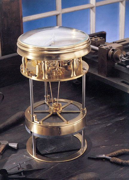
This timekeeper was the first American-made marine timekeeper taken to sea. William Cranch Bond, a 23-year-old Boston clockmaker, crafted it during the War of 1812.
Navigating at Sea is an immersive environment that suggests a walk through a 19th-century sailing vessel. Visitors will learn how centuries ago navigators at sea relied on chronometers and measurements of celestial objects to determine location. This section includes a mariner’s astrolabe, dating from 1602; a Ramsden sextant and dividing engine; several chronometers; a model of Galileo’s pendulum clock; and the earliest sea-going marine chronometer made in the United States, produced by Bostonian William Cranch Bond during the War of 1812. It also features an interactive display that allows visitors to use a sextant to navigate with the stars.
Navigating in the Air relates how air navigators struggled with greater speeds, worse weather and more cramped conditions than their sea-going predecessors. It tells the story of the innovations that overcame these challenges, as represented the gallery’s largest artifact, the Lockheed Vega “Winnie Mae,” flown by Wiley Post and Harold Gatty, shattering the around-the-world record in 1931. Visitors will learn that Charles Lindbergh required navigational tutoring after he flew to Paris and how he paved the way for a new system of navigation in the process. A personal account by a WWII navigator highlights wartime innovations. This section ends with an explanation of how clocks with tiny quartz crystals opened an entirely new era of navigation in the form of LORAN (LOng RAnge Navigation).
Wiley Post’s Winnie Mae circled the globe two times, shattering previous records. The first time was in 1931 with Weems associate Harold Gatty as lead navigator. The second was a solo flight in 1933 assisted by “Mechanical Mike,” one of the world’s first practical autopilots.
Navigating in Space traces how teams of talented engineers invented the new science of space navigation using star sightings, precise timing and radio communications. This section includes an Apollo sextant, a space shuttle star tracker, timing equipment used at a ground tracking station and a flight spare (duplicate spacecraft) of Mariner 10, the first spacecraft to reach Mercury.
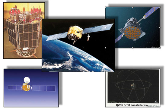
Inventing Satellite Navigation describes how traveling in space inspired plans to navigate from space. Innovators found that time from precise clocks on satellites, transmitted by radio signals, could be used to determine location. The U.S. military combined several breakthroughs to create the Global Positioning System. Some of the artifacts in this section are the NIST-7 atomic clock that served as the U.S. time standard in the 1990s, the navigation system from the nuclear submarine U.S.S.Alabama, a satellite from the Transit system used for global navigation before GPS and a test satellite global navigation built at the Naval Research Laboratory.
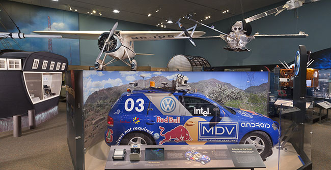
An official DARPA photograph of Stanley at the 2005 DARPA Grand Challenge. Stanley, created by the Stanford University Racing Team, won the race.
Navigation for Everyone tells the stories of real people — a fireman, a farmer and a student — who use modern navigation technology in their everyday lives. It also addresses what might come next: the story is not over yet and many new technologies are being developed. This section includes a disassembled mobile phone with a diagram showing all its parts and depicts how hundreds of years of navigation technology are now in the palm of a user’s hand. It also features “Stanley,” the robot car that won the 2005 Grand Challenge, a robot race sponsored by the Defense Advanced Research Projects Agency.
The exhibition is made possible through the support of Northrop Grumman Corporation; Exelis Inc.; Honeywell; National Geospatial-Intelligence Agency; U.S. Department of Transportation; Magellan GPS; National Coordination Office for Space-Based Positioning, Navigation and Timing; Rockwell Collins; and the Institute of Navigation.
The National Air and Space Museum building on the National Mall in Washington, D.C., is located at Sixth Street and Independence Avenue S.W. The museum’s Steven F. Udvar-Hazy Center is located in Chantilly, Va., near Washington Dulles International Airport. The National Museum of American History collects, preserves and displays American heritage in the areas of social, political, cultural, scientific and military history.
Bradford W. Parkinson, professor of Aeronautics and Astronautics Emeritus at Stanford University, discussed “GPS for Humanity — The Stealth Utility” at a special Smithsonian event Thursday, March 21. If you missed his talk, you can view it now on UStream.
According to the Smithsonian, for centuries, nations have invested enormous resources to determine time and place for geopolitical reasons, and their research has changed people’s view of the world. Advanced technology that was once available only to the military has become commonplace in car dashboards, cell phones and a growing number of other portable devices of daily life. The Time and Navigation exhibit explores how revolutions in timekeeping over three centuries have influenced how people find their way. It is organized into five sections: Navigating at Sea; Navigating in the Air; Navigating in Space; Inventing Satellite Navigation; and Navigation for Everyone.
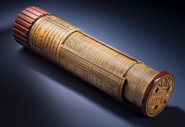
Bygrave Position-Line Slide Rule.
Andrew Johnston (geographer, Center for Earth and Planetary Studies, National Air and Space Museum) gave a presentation about the exhibit at ION GNSS in Nashville, Tennessee.
In the 1970s, Parkinson was the chief architect and original program director for GPS. In his lecture, he will present the history, applications, and future of GPS and the GNSS. Central to operation of GPS is the relationship between time and navigation, and GPS will be explored in the Time and Navigation exhibit.
Dr. Bradford W. Parkinson, professor of Aeronautics and Astronautics Emeritus at Stanford University will discuss “GPS for Humanity — The Stealth Utility” at a special Smithsonian event Thursday, March 21.
In the 1970s, Parkinson was the chief architect and original program director for GPS. In his lecture, he will present the history, applications, and future of GPS and the GNSS. Central to operation of GPS is the relationship between time and navigation, and GPS will be explored in the Time and Navigation exhibit.
As part of the Stanford Engineering Hero Lecture Series, Brad Parkinson will present a talk on “GPS for Humanity” Monday, April 30, at 7 p.m. Pacific Time. The lecture will be broadcast online at no charge. If you would like to view the live broadcast, register at the Stanford University site.
In large part, Parkinson will present the story he told in GPS World, The Origins of GPS, Part 1 and Part 2. Here is the lecture description:
More than anything else, GPS has become the United States’ gift to humanity. Cell phones rely on GPS for timing. Ship and aircraft carry multiple GPS receivers to provide positioning information. Other applications range from earth movement to disease tracking to search and rescue. Dr. Bradford Parkinson, chief GPS architect and Stanford Professor Emeritus of Aeronautics and Astronautics, will describe the origins and applications of GPS and explore its future, including one application enabled when the world has more than 50 interchangeable civil signals.
Bradford Parkinson is chief architect of the now-ubiquitous Global Positioning System (GPS), which he led as a U.S. Air Force colonel in 1973. As a professor at Stanford, he pioneered GPS for aviation and other applications, including the Wide Area Augmentation System (WAAS) used by the FAA. More recently, he led the NASA/Stanford Gravity Probe B program that validated Einstein’s General Theory of Relativity to an unprecedented accuracy. Parkinson is co-editor and an author of the best-selling textbook, Global Positioning System: Theory and Applications.
The recent furor concerning President Obama telling Israel to withdraw to its 1967 pre-war boundaries brought back some vivid memories for me. I was there in Israel in 1967, coincidentally and thus unintentionally covering the Six-Day War for Radio Free Europe, along with several other genuinely surprised correspondents and journalists. We encountered many unusual situations and not a few difficulties, which I will relate shortly.
In his Mideast statement, the President obviously misread his GPS (Geo-Political Situation) where Israel is concerned. He, along with his appointee at the Federal Communications Commission, also misreads the needs of this nation, and here I’m talking about the real GPS — the Global Positioning System.
The two scenarios — Israel in 1967 and the United States today — are connected, and that connection has to do with GPS. I urge all my readers to take prompt action, as outlined at the end of this column. Believe me, it is in your own best interest.
Navigation in 1967
One of the difficulties my fellow journalists and I encountered in 1967 was navigating around Israel in the pre-GPS era. All we had then were paper maps, of course, and after six days everything had changed, and not in small ways, either. Plus, there were mined roads and mined pathways everywhere that were not marked accurately on any map, but were marked on the ground with white flags that approximated the area of the minefield.
Think for a moment about navigating through minefields with simple paper maps as designators, and hopefully that will get your attention and give you some idea of the daunting navigation challenges we faced in 1967.
If President Obama, the Federal Communications Commission, and LightSquared have their way, we may soon find ourselves navigating without GPS and reverting to paper maps here in the United States as well. I wonder if that is really the legacy for which the Obama administration wants to be remembered: destroying the efficacy of the greatest satellite constellation ever placed in orbit. More on the FCC and LightSquared later.
Return Visits
I have returned to Israel several times over the last 44 years on various military assignments, including one to the vastness of the Negev desert, which comprises half of Israel’s southern landmass, where there are few discernable landmarks. Navigating in the Negev can be a daunting task without GPS, because believe me when I say Israel is still a country surrounded by a host of enemies. This means that a wrong turn when you are navigating close to those borders can be disastrous, even fatal; for that reason among others, GPS units are very popular in Israel. Almost everyone I met had one or more units. Handheld units are extremely popular because you can get just as lost and in as much trouble walking around and making wrong turns as you can by driving, even in the Israeli capital of Jerusalem.
Consequently there are several Israeli companies today that produce excellent GPS units, including ruggedized military units. In fact, an Israeli company makes one of the best military SAASM GPS units for warfighters manufactured today. But that is another story, for another time. For now let’s briefly travel in time back to 1967.
There I was…
For reasons probably left better to the imagination, I found myself in Israel just as the Six-Day War drew to a rapid close. At the time I was attending University Abroad in Munich, Germany, and working as a broadcaster for Radio Free Europe. Even though I had not planned it, I was able to cover the immediate aftermath of the Six-Day War on the scene for Radio Free Europe as a foreign correspondent. Great shades of Edward R. Murrow.
It was an amazing, tension-filled, historical moment that I will never forget. As I mentioned, one of those memories involves how we managed to navigate around a country that had just won a war conducted throughout its own and neighboring territories. To say that navigation in post-war Israel in 1967 was sometimes a major issue is putting it mildly.
For example, during a memorable journey from the port of Haifa to our quarters in Jerusalem and then on to our destination of Masada, near the Dead Sea, we used several different forms of transportation. We departed the busy port city in a tour bus to Jerusalem, and then continued by desert trucks toward Masada. Halfway there, we switched to horses, then to camels, and our final transports were tiny burros supposedly able to carry us up the ramps at the lofty 2,000-year-old natural stone fortress steeped in history.
Granted, all these forms of transportation were not strictly necessary, but since we were in Israel for the experience, an unforgettable experience is what transpired — although a full-blown war and its exciting but very confusing aftermath were not exactly what we had envisioned. I might add that we were constantly accompanied by bodyguards and a security force for the entire duration of our visit, which was vaguely comforting and troubling at the same time. I will never forget our first meal at Masada when we were able to converse with our bodyguards and ask the proverbial question, “What did you do during the war, Jacob?” The answer was of course “If I told you I would have to …” Well, you know the rest. Aerial view of Masada and the remains of the camp of Roman besiegers built in 73 C.E.
Considering all the forms of modern and ancient transportation we utilized during our visit, you might ask how we managed to navigate accurately, since the GPS was of course still eleven years away even from its initial launch, let alone operability.. The answer is, we navigated as accurately as possible and we did it the old-fashioned way, using the pre-1967 version of GPS: Global Navigation & Planning (GNC) maps, ancient street maps, and at times hand-drawn maps. The GPS abbreviation in 1967 stood not for Global Positioning System but for Going Places Slowly, while stopping every fifteen minutes to consult a paper map of dubious accuracy.
Today
Today, of course, the trip from Haifa to Jerusalem and then to the storied fortress of Masada can be made on a fancy European tour bus in air-conditioned comfort, and you can take a cablecar to the top of Masada. Once there, you might be able to just barely see the Dead Sea, which is much further away now than it was in 1967. Yes, unfortunately the Dead Sea is shrinking drastically, due to the high demand for water in Israel today. It is barely visible from the top of Masada’s highest vantage point. You might find it interesting to know that all the young men and women in the Israeli armed forces today take their oaths of allegiance atop Masada. The reasons are historical and make interesting reading, check it out.
Today, of course, everyone navigates accurately to all these wonderful historic venues with a handheld or vehicle-mounted GPS. And believe me, as I said, it seems that everyone in Israel has at least one. And no one in that country today, for personal and security reasons, wants to go back to the old days of navigating with paper maps, where one wrong turn can be catastrophic.
Lessons Learned
So anytime you find yourself being the least bit complacent about GPS and what it does for you, think about what it is like to live in Israel, where GPS has revolutionized the way an entire county navigates and literally serves as a lifesaving device every single day.
Here is the United States, we tend to take our technology for granted — no surprise there — but when you find yourself in some place like Israel, Iraq, or Afghanistan, and your life
literally depends on a satellite system 12,500+ miles up in space, believe me, you no longer take it for granted.
An Enabler
Always remember: GPS is a ubiquitous utility that is provided to the world free of charge, as a gift from the United States government. Countries around the globe, including Israel, use the positioning, navigation, and timing (PNT) capabilities enabled by GPS for critical national infrastructure, for military planning and execution, and yes, for everyday navigation. Plus, as I have stated many times, more than 90 percent of the 1 billion-plus people around the world who use GPS, use it for time and all the capabilities that time accurate to 1×10-E14 enables.
Will It Be There?
Please never take your GPS for granted. Part of not taking it for granted is ensuring that GPS is available and is protected from encroachment and jamming by companies like LightSquared. If LightSquared has its way, and its FCC terrestrial license is not revoked, then the company will be able to legally jam GPS and deny everyone in the United States from enjoying the innumerable activities that GPS enables around the globe.
Does that make sense? The U.S. government provides the GPS service globally, but we in the United States cannot benefit from it because a private company has convinced the FCC that being able to Google or Twitter on a cell phone in the middle of Kansas is more important than all the industries and capabilities that GPS enables, not to mention the $100 Billion in revenue that the GPS industry generates every year?
I ask again — does that make sense?
Bottom Line
Let’s hope we never have to fight another war on our homeland, because if we do and LightSquared and the FCC have their way, we will do it without GPS. We will find ourselves navigating by the seat of our pants, just as I did in Israel in 1967. Call your Congressman and complain loudly about LightSquared and the FCC. Help put an end to this insanity.
Until next time, Happy Navigating.
P.S. Our 1967 group of war correspondents included the grandson of former British Prime Minister Sir Winston Churchill, who was named after his famous grandfather. Young Winston wrote an excellent book about the war shortly afterwards. If you want to know more about the Six Day War from an eyewitness then I highly recommend The Six Day War by Randolph S. Churchill and Winston S. Churchill. As I was there, I can verify that Winston’s book is forthright and factual. Winston tells it like it was with no dithering of the facts for political correctness.
Colonel Bernard Gruber, director of the GPS Directorate.
Don Jewell (DJ), our Defense Editor, caught up with Colonel Bernard Gruber (BG), the newest director of the newly renamed Global Positioning Systems Directorate at SMC in Los Angeles, California. They discussed the current status of the GPS program and the way ahead. Don caught Colonel Gruber just before he departed for the East Coast for an Executive-Level Acquisition Course at the Defense Acquisition University at Fort Belvoir, Virginia.
DJ: Colonel Gruber, thanks so much for taking the time to talk with us today. I know you are a busy man. I know our readers would benefit from a GPS program status update, and I hoped we might also discuss the future of GPS if you are comfortable with that?
BG: It would be my pleasure, and Happy New Year to you, Don.
DJ: Thank you, sir. One of the questions I have been asked many times is how will the re-designation as a Joint Program Office or GPS Systems Directorate versus a GPS Wing affect operations and day-to-day activities, and will it have any impact on your effectiveness as an organization or on the user community? And what exactly is your title now, anyway? I have heard so many versions. Set us straight please.
BG: Great first question, Don. It’s been almost five years since we’ve been assigned as a Joint Program Office. And while I answer to a lot of things, my title is now officially the director of the Global Positioning Systems Directorate. The re-designation to the GPS Directorate is basically transparent when considering day-to-day activities and our effectiveness. We are still the same strong organization with the same mission and goals. We still develop, acquire and sustain GPS space, ground, and user equipment and want to keep GPS as the world’s gold standard for positioning, navigation, and timing, and the “joint” aspects of our program are as strong as ever.
DJ: That’s great to hear sir, so business as usual, just a unit re-designation to work through. Now let’s get to a space segment question. The first GPS IIF (IIF SV-1) is on orbit and reportedly performing better than expected. Could you provide us with a status update as well as a forecast for when IIF-2 will be ready for launch, and do you expect the same performance as IIF-1?
BG: The first-ever GPS IIF (SVN-62) is performing its navigation mission well and with the best atomic clock performance ever seen on-orbit. GPS IIF SV-2 is in final integrated system test and on track for a summer 2011 launch. We are heavily focused on getting these first couple of vehicles absolutely right to ensure that our production run of the remaining 10 IIF vehicles stays on track to support the GPS constellation. We expect to see solid performance meeting all requirements from SV-2 and all GPS IIF satellites.
DJ: Well, we certainly hope that prediction comes true. The last time we checked the GPS IIIA program was on track as well, and perhaps even a bit ahead of schedule. Has anything changed, and how do you foresee the future of the IIIA program?
BG: Don, we are still on track; the program has switched its focus from design to manufacturing with half of our 59 manufacturing readiness reviews completed to date. On December 17, the GPS IIIA space vehicle program received Milestone C approval, as well as authorization to initiate “long lead” parts procurement for the first two production satellites. This was a huge accomplishment for the whole GPS team. A total of eight GPS IIIA satellites will be built, with first delivery scheduled for spring 2014.
Additionally, the Bus Real Time Simulator (BRTS), which is the first deliverable on the contract, was received by the government in September 2010. The Assembly, Integration, and Test facility construction in Denver, Colorado, is on schedule with the outside of the building fully enclosed. So, yes, we’ve been making huge progress since we successfully completed, two months early, our GPS IIIA critical design review last August.
DJ: We hear the term all the time, but just what is Milestone C for the GPS IIIA program? And can you tell us a little more about the BRTS?
BG: Sure. We use these terms all the time and forget that there is another audience out there that does not use them on a daily basis. Milestone C is formal approval of the work completed in engineering and manufacturing development and approval to enter production and deployment, specifically low-rate initial production (LRIP) for most programs. For satellite programs, such as GPS IIIA, this is approval to begin production. As mentioned, we were approved for long-lead parts buys for our first two IIIA production vehicles, SVs 3 and 4. It might be interesting to note here that SVs 1 and 2 were bought with research and development (R&D) dollars, just a different color of money appropriated by Congress.
As mentioned, the BRTS was one of our very first deliverables on the IIIA contract. What we do with the BRTS is we take the simulated GPS signals that come from the A2100 bus that’s part of the Lockheed Martin GPS III system. This allows us to work through all the interface, data, and timing issues we have. Physically, it sits across the street from Los Angeles AFB in the laboratory in the Aerospace engineering facility.
DJ: Now the OCX program (Global Positioning System (GPS) Advanced Control Segment) is also reportedly on track, but historically ground support programs for space programs have always been a problem and a long pole in the tent for GPS. Can you give us an update on OCX and what we can expect in the next couple of years?
BG: Yes, I can. Since contract award last February, several reviews have been successfully completed: namely the Technical Baseline Review (TBR); Integrated Baseline Review (IBR); Software Specification Review (SSR); and a Hardware Preliminary Design Review (HPDR). We are planning for a system Preliminary Design Review in the spring of 2011. I know that’s a lot of reviews, but all of these will lead us to a Milestone B decision by the DOD, and is anticipated by the third quarter of fiscal year 2011, and reduce our risk posture along the way.
Now before you ask [laughs], a Milestone B decision is formal approval of work completed in the Technology
Development phase and approval to enter into the Engineering and Manufacturing Development phase. As you know, with OCX, we completed a source selection in February, which was a down-select from the two phase A contracts to a single developer — Raytheon Space Systems in Aurora, Colorado.
Over the next couple of years, you can expect us to set up facilities, buy hardware, and continue software development until delivery of the first block in 2015.
DJ: Thanks for clearing that up. Now for one of my favorite topics; what about the MUE and MGUE programs?
BG: The Modernized User Equipment (MUE) program was established to leverage technology demonstrations to significantly reduce risk and ensure a high probability of success for the Military GPS User Equipment (MGUE) program. We have received working hardware from each of the three MUE vendors and government testing is under way. The MGUE program has progressed nicely through the latest series of program reviews and we anticipate a Milestone A decision in early 2011.
Now, to be consistent, I guess
I should define Milestone A, which is formal approval of a program’s Materiel Solution Analysis to go into Technology Development. For MGUE, we have written a Technology Development Strategy document, using lessons learned from the MUE program, which highlights the acquisition strategy of the new program. This document has been approved by senior Air Force acquisition officials, and we are working to achieve OSD (Office of the Secretary of Defense, Robert Gates) approval in February.
MGUE will provide the warfighter with next-generation capabilities including a more secure GPS receiver and use of a more robust GPS military signal.
DJ: That’s great. Plus we managed to hit all three milestones and you defined them for us. Now what about flex power? We heard there might have been more problems than first announced when all the data from the flex power demonstration was analyzed. Any comments?
BG: After all was said and done, we considered the exercise of flex power in 2010 a great success. As you noted, there were a couple of older GPS receiver designs that exhibited unexpected behavior. To date, we have identified the issues and we now understand the behavior of these receivers during flex power conditions. Along with our sister wing, the 50th at Schriever AFB, the GPS Directorate is working with each of the affected organizations to determine the extent of operational impact, if any, and to identify acceptable techniques, tactics, or procedures that would allow these organizations to operate nominally in a flex power environment.
DJ: Colonel Gruber, let’s stay with the user equipment topic for a moment more. What are you able to tell us about OTAD (over-the-air-distribution) and OTAR (over-the air-re-keying)?
BG: Thanks for asking Don. A [cryptographic] key is required to unlock access to the GPS military signal. These keys are typically distributed to each military user and periodically loaded directly into each GPS receiver. As the number of military users has grown, the logistics for distributing these [physical] keys has become logistically more difficult. An over-the-air distribution capability has recently been added that facilitates the distribution of keys directly to military GPS receivers via the GPS signal, instead of physical contact or connection. We are confident this capability will help to alleviate some of the burden associated with physical key distribution. An on-orbit OTAD exercise was recently held to validate the capability and to help train users. The test, designated Transition Exercise #7, was successful and the GPS Directorate is excited to see this capability come on line in the near future.
DJ: Certainly we know having to key military GPS receivers sometimes presents a problem and many military users (warfighters) say it can be cumbersome and time-consuming. What do you say to the warfighters that repeatedly say these are many of the reasons they have gone to commercial and civil equipment in theater, not only as a backup but sometimes as their primary PNT equipment?
BG: The first thing that must be kept in mind is this: commercial and civil equipment is susceptible to being jammed or providing misleading information as a result of electronic attack. Warfighters depending on the integrity of their GPS data on the battlefield are assuming a significant operational risk when using commercial receivers, comparable to conducting military missions using non-secured communications. We understand that military receivers cannot always compete with commercial products in terms of the ability to rapidly incorporate the latest technology, so it is important that we receive user inputs so we can incorporate changes, if possible, in current receivers or into the design of new receivers.
DJ: Speaking of the integrity of GPS receivers, should we be on the watch for another major ground control segment (AEP) update any time soon?
BG: Again, with the 50th Space Wing, we actually just released and fielded AEP (Architecture Evolution Plan) Version 5.6 of our ground software. Part of our efforts to ensure seamless transition of these updates has been to develop a release process that includes a pre-engagement strategy and a test suite with many variations of current GPS user equipment. The next major update will be AEP Version 5.8. It is planned to complete depot-level software testing in the fall of 2011 and is scheduled for fielding in early 2012.
DJ: So, no new AEP updates to concern users for a while. However, there is currently a Sources Sought for GPS IIIA launch capability that was just released. Is there a problem projected with launching IIIA satellites that we don’t know about?
BG: There is no problem projected with launching the IIIA satellites. The GPS program has implemented a new concept of operations (CONOPS), where on-orbit testing is conducted by the program office before turning the satellite over to operations. The first GPS IIIA satellite will launch prior to the new control segment (OCX) being operational; therefore, we have taken measures to ensure a system is available to fully checkout the first IIIA spacecraft. This system, called LCS (Launch and Checkout System), ensures the maximum value of on-orbit testing to GPS III production, which in turn provides an on-orbit asset for test and checkout of the new OCX control segment as it becomes available for operations. We expect OCX and the first GPS IIIA satellite to be operationally available simultaneously.
DJ: So, what exactly makes the launch process so different between the IIAs, IIRs, IIFs, and IIIAs?
BG: Fundamentally there are no differences with the exception of the new CONOPS, which has gone into effect with the launch of the first GPS IIF. As I mentioned earlier, the GPS Directorate is now responsible for conducting on-orbit testing prior to turning the satellite over to the operational community.
DJ: Now talk about a CONOPS change; this certainly sounds like a major change in policy.
BG: Actually, Don, it is not so much a change as a move to comply with current policy. An AFSPCI (HQ Air Force Space Command Instruction) currently specifies that the program office must certify the satellite performance to the 14AF (14th Air Force) and the command (AFSPC) on-orbit. While this is commonly practiced by other space programs, GPS has been an exception. It aligns the authority to conduct the test with the program director’s accountability for its outcome. The change aligns GPS with the AFSPCI, and was first implemented on IIF-1.
DJ: So this is a major CONOPS change that means now you are responsible, that is the GPS Directorate, for the satellite from procurement until it is declared operationally ready and turned over to the 2 SOPS (2nd Space Operations Squadron) at Schriever AFB in Colorado. And you went through that process for the first time on IIF-1. Interesting.
That brings us to the next family of GPS satellites to be launched after IIF and that is IIIA. When exactly can we expect the first IIIA launch to occur?
BG: We are still on track to deliver the first GPS IIIA to
support a forecast late spring 2014 launch.
DJ: Colonel Gruber, uncharacteristically the GPS IIIA launch date has actually moved to the left or earlier on the calendar. If the IIIA launch date keeps moving to the left, could you find yourself in the position of launching a GPS IIIA before the last IIF is launched?
BG: As currently foreca
st, the first IIIA certainly could launch prior to the last IIF. While we will continue to work this with the 50th and through the 14AF, this may be a plan that helps the GPS program maintain itself as the gold standard for positioning, navigation, and timing. To that end, it will give us the ability to test and characterize the first on-orbit IIIA while still keeping IIFs in reserve.
DJ: Other than the major CONOPS change we just mentioned, what other significant changes have you made since you have been the new GPS Wing commander and now the director of the GPS Directorate?
BG: To be honest, Don, not many. Basically, we are continuing to build on the tremendous work of Colonel (USAF, Ret.) Dave Madden. With that in mind, I spent the first 30 days just listening and learning. That gave me an opportunity then at the 90-day point to release my Director’s Intent for 2011. And shortly thereafter, I signed out the Directorate’s Strategic Plan that put our organizational goals and objectives into three bins:
Mission Effectiveness, which equals mission assurance
Mission Efficiency, which equals return-on-investment, and
Taking care of our people — always.
Although I didn’t change a lot, I did energize (or maybe re-energize) a few key areas. First, I wanted to close the gap between OCX and GPS IIIA, which we have now effectively done; second, I am taking another look at dual launch for future GPS space vehicles, including the use of new lithium ion (LiON) batteries and a lighter weight interface between the space vehicle and the launch vehicle; and third, I want to put a clear focus on standards so that vendors can exploit new technology and solutions for future user equipment.
DJ: What significant challenges then do you see in your future tenure?
BG: I think our biggest challenge is potential budget constraints in this fiscally constrained environment. Program stability is absolutely paramount for program success, and program stability requires three legs:
Requirements stability
Funding stability; and
Personnel stability.
We’ll keep our eye sharply on all three.
Another major challenge facing the GPS Directorate is the proliferation of GPS user equipment, both from the perspective of the hostile intentions of our enemies, as well as interoperability or compatibility with the sheer number of GPS receivers out there. To that end, we have embarked upon an “Underwriter’s Laboratory” construct for security and performance validation.
DJ: Colonel Gruber, I want to thank you again for your time today and ask as a final question if there are any closing comments you would like to make or any additional topics you would like to discuss?
BG: Don, the great thing about the GPS program is that everyone truly wants to make this system work, and I’ve found that people understand GPS is a worldwide utility. As I hope I’ve articulated, we have an exciting future in this program, and you can clearly see how much is going on. And Don, let me say that I appreciate folks like you and GPS World magazine who continue to educate people around the world about our system. To that end, I would like to close with a special thanks to the men and women of the GPS Directorate for their tenacity, unparalleled work ethic, and incredible dedication to mission success.
DJ: It is our pleasure, sir, and again, thanks for your time and for the update. Good luck at Ft. Belvoir.
The articles in the May and June issues of GPS World on the origins of GPS by Drs. Bradford Parkinson and Stephen Powers presented a detailed view of the people involved in the development of the GPS Program. This view on the origin of GPS essentially begins with the so-called “Lonely Halls” meeting where Dr. Parkinson and a group of Air Force officers invented the GPS concept that was subsequently developed by the teams of people discussed in some detail.
Missing from this view of the origin of the GPS concept are the developments and events leading up to the final decision on what was to have been the Defense Navigation Satellite System. The development, we are now expected to believe, originated from an Aerospace Corporation Study of 1964. The major events in the pre-history of the GPS program are not as well known as the events after the formation of the GPS program since, like the Aerospace study, they were classified and not generally available. Many of the documents of that pre-history have become declassified so that a more historical perspective can be made based on the actual documentation of events rather than subjective recollections of events.
Having worked during that era, I began as a naval officer assigned as the TIMATION project officer, Navigation Satellite Branch, Astronautics Division, Naval Air Systems Command, from 1968 to 1971. After separation from active duty I began working at the Naval Research Laboratory (NRL) in June 1971 in the TIMATION program, through the origination of the GPS Program, the Navigation Technology segment of the GPS program and became the head of the NRL Space Applications Branch in 1984 onwards. I believe I have a unique perspective on the origins of GPS, having participated from the Navy side. In the following I have attempted to describe the evolution of the TIMATION project and events leading up to establishing the GPS Program from the official Navy record.
It should be evident in this discussion that at the formation of the GPS Program, the TIMATION project ended, and the efforts following at NRL on NTS and space clock development were funded by the Navy as part of a Joint Program under the managerial direction of the GPS JPO. This relationship has been considerably de-emphasized and confused over the years, to the point where very few remember it.
The TIMATION project originated in FY 1965 as the Rapid NAVSAT Readout project under tasking by the Bureau of Naval Weapons. This Exploratory Development project was to investigate the feasibility of advanced navigation satellite techniques, among which was the concept of using passive ranging. The project included a number of experimental investigations into the concept of utilizing passive ranging based on precise time synchronization between a satellite and user receiver to produce more accurate and rapid positioning. An experimental satellite was developed and launched into low earth orbit for experiments in determining accurate satellite ephemerides and demonstrating a simplified technique for position fixing based on celestial navigation concepts. These techniques were intended to demonstrate, but were not limited to, two-dimensional positioning. Position fixing utilizing the celestial navigation plotting technique also determined the time offset of the clock in the user receiver so that it could be corrected for positioning or applied to time transfer techniques. An atomic clock was not required. A number of navigation and time transfer experiments were performed with this first satellite and data was collected for analysis of the concept. Another satellite was designed to incorporate the lessons learned from the first satellite and to perform other analytical studies. It was ultimately launched in 1969.
However, in 1968 the Joint Chiefs of Staff (JCS) formed a Navigation Requirements Panel to conduct a study, the results of which were approved on 24 September of that year. The new joint service navigation requirements established by this study included the ability of a user to precisely position themselves in three dimensions and precisely determine their velocity, continuously and worldwide. During the year following establishing of these new JCS requirements, the TIMATION project was expanded to address these new joint service navigation requirements.
Consequently, from 1968 through 1970 the TIMATION concept grew from a category 6.2 exploratory development project into navigation satellite techniques to a 6.3 advanced development system concept employing a constellation of medium altitude satellites containing space qualified atomic clocks to a worldwide distribution of various, surface and airborne, passive ranging user equipment. Technical design studies conducted were designed to analyze or experimentally demonstrate the technical aspects proposed to be selected for the DNSS. The specific technical areas that were investigated were: specific frequencies to be used, single or dual frequencies, and the propagation errors associated with their use; arrangement of the constellation of satellites, total number required for worldwide coverage and quality of coverage; ground stations necessary to operate the satellites and their location (foreign soil or U.S. territory); ranging signals to be used, the accuracy provided, resistance to countermeasures and vulnerability to such things as multipath reflections into a simple user antenna; and capability of being denied to the enemy.
The Navy and the Air Force 621B concepts were the two principal competing DNSS concepts for providing accurate three-dimensional navigational capabilities.
In 1970 the Astronautics Division of NAVAIR, sponsor of the TIMATION project, requested preparation of a system development plan to include a demonstration phase which could directly transition into an operational system. Such a plan was required for the Advanced Development phase (category 6.3 funding) of the project, which began with the establishment of the Advanced Development Objective (ADO) 34-11X, the requirements document for the project. The plan described the project requirements, approach, and objectives in some detail. In their guidance letter to NRL, NAVAIR provided guidance on the content of the development plan. The primary technical requirement for the effort was the “Precision navigation requirements in Phase I of the JCS Navigation Study approved 24 September 1968. — The most stringent requirement (being) user three dimensional position within the stated accuracies continuously on a global basis.”
At NRL a GPS program office (Code 7907) was set up in March 1974 to coordinate GPS activities with the GPS JPO and manage NRL program activities. [ . . . .]
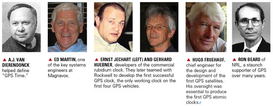
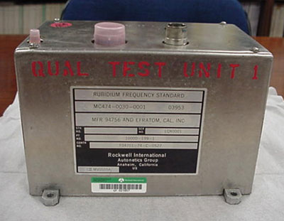
The development of space qualified atomic clocks at NRL, which had recommended and initially focused on cesium standards, began with the experimental rubidium standards on NTS-1. It was originally intended for experimentation with improved quartz crystal standards. The opportunity to include experimental rubidium clocks on NTS-1 presented itself some eight months before the satellite was completed. A new small rubidium frequency standard, model FRK, from Efratom of Munich became available and even though they were not specifically designed for space
their small compact size and design was attractive as a candidate space clock. Several of the FRK models were purchased from Munich, evaluated and modified for a space experiment in NTS-1. Two units were integrated into NTS- 1 and operated alternately with the primary quartz crystal standard. This same Efratom Model FRK was selected and proposed by Rockwell International for use in their Block I satellites. [. . . . ]
The clock development conducted and proposed by NRL was the subject of special program interest during these formative years. In February 1974 DDR&E in a memorandum to ASN (R&D) pointed out that “One of the most vital efforts in the recently approved NAVSTAR Global Positioning System (GPS) is clock development. Funds have been programmed under PE 63401N, NAVSTAR GPS, for programmatic developments defined in the DCP. However, there is a small, but important, effort which should be undertaken … I refer to the development of Space Qualified hydrogen maser clock and its correlative counterpart for the ground control station.” These funds mentioned and subsequent development efforts were Navy funds as part of the GPS joint development effort. The importance and emphasis on space qualified atomic clocks was highlighted in the DDR&E expansion of the GPS Phase I program to support the Submarine Launched Ballistic Missile Improved Accuracy Program. In that memo DDR&E called upon the Navy “to expand their NAVSTAR clock development effort. To reduce risk and provide timely NTS-2 support for the expanded satellite program the Navy should provide a second, parallel, cesium clock development, to be done by an aerospace contractor, for use on NTS-2. If either or both of the cesium clocks perform satisfactorily, cesium clocks should be used in any satellites subsequent to the initial six. The Navy NAVSTAR program should also provide in FY 1976 and beyond for (1) a hydrogen maser development for the NAVSTAR ground stations, and (2) efforts leading to a space qualified maser suitable for NTS-3 and future satellites.”
Considerable documentation and other material describing the extent and contributions to the GPS program resulting from the TIMATION development beginning in early 1974 could be further detailed. But in the interest of keeping this letter relatively brief those aspects will be covered elsewhere.
It should be evident in this discussion that the TIMATION project ended at the formation of the GPS Program. The subsequent NRL efforts on NTS and space clock development were funded by the Navy as part of a Joint Program under the managerial direction of the GPS JPO, however, many of the fundamental concepts and approaches began during the TIMATION program.
It is worthy to note as well, that over the years in addition to the recognition afforded Dr. Parkinson as the first program director of the GPS program, the contributions by Roger Easton and NRL have also been recognized. This recognition includes NRL being included as a major contributor to GPS in the Collier Award of 1992.
— Ronald L. Beard
Head, Space Applications Branch,
Space Systems Development Department,
U.S. Naval Research Laboratory,
Washington, D.C
Brad Parkinson replies:
I have great respect for Ron Beard and the many other fine engineers and spacecraft developers at NRL.
That said, I respectfully submit that the letter completely misses the point. There was a substantial amount of Pentagon infighting up to the time I took over the Program in late 1972. Ron has done a great job in documenting this cumbersome history. It accurately shows the paper trail from the NRL point of view. Dr. Currie reset the direction when he designated me to lead the Joint Program in 1973. The past assignments were essentially overtaken by that decision. There is another set of paper, that could be dredged out of the USAF files, but to little point.
The central issue is not paperwork. It is who conceived the concept, demonstrated the technique on the ground, and built the prototype system.
With a wave of the hands, NRL declares their system was also three-dimensional, yet the Easton patent clearly was not and the patent was clearly burdened with a militarily- vulnerable signal structure. Apparently they disown their own preferred design. Yet, the patent is the clearest public record of NRL thinking.
The letter ignores:
The first clear explanation of the tradeoffs between the various space navigation alternatives was the 621B “Woodford and Nakamura” study of 1964/66. It included the three-dimensional technique we selected in the final GPS design.
The essential keys were: A. Single frequency transmission (CDMA) and B. Simultaneous ranging to four satellites. Both keys were conceived by 621B and demonstrated by the White Sands testing of real hardware (1970/1973). This became the basis for the GPS design in 1973. It is also the basis selected for all of the “copycat” systems by other countries (Russia has now announced a CDMA signal). NRL cannot point to any advocacy of such a system.
NRL was indeed (as Ron points out) charged with clock development (but their spacecraft CDMA transmitter was provided by the JPO, not by NRL). Note that the early 621B study advocated atomic clocks in space for the system. NRL was not able to provide a useful space-borne clock until the fifth GPS prototype satellite. This was after the Rockwell/Efratom clock had become the only operational satellite clock used in the first four prototype satellites and after the GPS system testing had gained approval to proceed to full-scale development in 1980. Problems with the NRL test satellite precluded its inclusion in the test constellation.
It is correct that NRL advocated a MEO system, similar to the one we adopted for GPS. The Air Force’s 621B had wanted to demonstrate the four-dimensional technique using spacecraft, and launching the system a world-sector at a time. There are pros and cons both ways, but the controversy was both political and technical. The key to our selecting the GPS MEO constellation design was that it enabled the 4-6 satellite sub-constellation that was star (not solar) synchronized and that technique can be attributed to Major Gaylord Green of the Air Force. This allowed the extended testing on our well-instrumented range at Yuma Proving Ground.
In 1973/74, my problem was to find a way to advocate the right system without re-igniting the NRL/621B warfare. At that time, I chose to ignore most of the true 621B heritage of the JPO proposal and, in public, talk up the NRL contribution. A number of my colleagues in Aerospace and the old 621B were very perplexed with my behavior. I felt it was the right path to allow us to proceed with actually building the system.
I genuinely supported the NRL clock technology efforts, and was very disappointed when they were not able to meet our schedule. The space-qualified cesium clock, developed under NRL/Bob Kern, was a phenomenal accomplishment in spite of being late.
— Bradford W. Parkinson,
Edward C. Wells Professor of Aeronautics and Astronautics (Emeritus)
and Hansen Experimental Physics Laboratory
Stanford University, Stanford, California
The first time I ever heard of the Magnavox Research Laboratory in Torrance, California, was in 1966, as a young engineer working at Hughes Aircraft. We were building large (46-foot diameter) ground stations for the Defense Satellite Communications System (DSCS). Magnavox was supplying the secret anti-jam modems used in the terminals.
Because of this, I also learned a little about spread-spectrum pseudo-noise (PN), something quite esoteric at the time and not taught in engineering school. I noticed a widespread respect for Magnavox from my colleagues who referred to the company and its equipment as “Magicbox.”
Within a year I had transferred to the Hughes division responsible for developing satellites. We were working on a study known as 621B, for using satellites for positioning. Our teammate for the study was Magnavox. That team was responsible for the payload signal design, for which the team chose PN as the modulation to provide for multiple access, ranging, data transmission, and anti-jam.
Before long, my boss decided to leave Hughes and go work for Magnavox. He took two of his systems engineers with him. I was one of them.
In1968, the U.S. Air Force could not yet sell the 621B concept as an Advanced Development Program, so instead opted to experiment and prove that PN modulation could be used to accurately measure a half-mile of cable. Hughes bowed out since there wasn’t any satellite procurement in the offing. Magnavox and the other 621B contractor, TRW, each took on the challenge of measuring the cable.
Where Hughes had been 10-deep in Ph.D.s in every discipline, Magnavox was 10-deep in PN experts, which I believe at that time was the world’s majority. Thus it was natural for the Air Force to ask them to continue, and develop a receiver to be used in the next phase of 621B. An inverted range was set up with four PN transmitters, and an aircraft with the receiver and a bottom antenna flew over them. The aircraft’s position was determined using the PN range measurements and the known locations of the transmitters. The data from that receiver, called the MX450, was used to help justify the Department of Defense (DoD) decision to proceed into the Advanced Development Phase of GPS. Some of the people who contributed to this were named in Dr. Brad Parkinson’s recent articles on the origins of GPS. During that time I was working on the next generation of spread-spectrum modems for the DSCS.
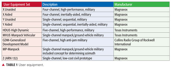
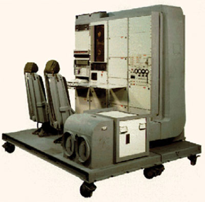
Magnavox went on to develop these PN satcom modems for all three services, and thus was a natural choice to develop the first military GPS receivers (known as X and Y sets and the first Manpack), as well as the first C/A receiver, the Z set, and the very first spaceborne receiver called GPSPAC.
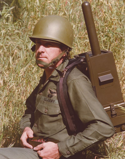
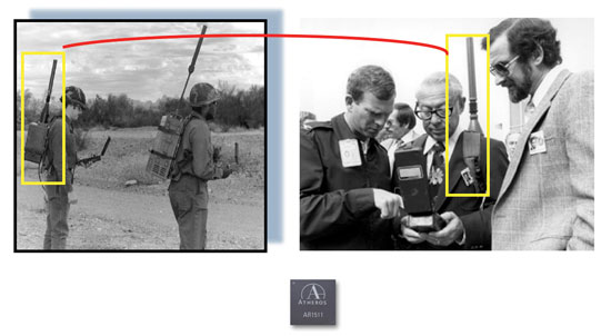
As soon as we completed the first Manpack, I approached Col. Paul Weber, the Joint Program Office Army Deputy Program Manger, and asked if he would pose with the Manpack on his back for a brochure we wanted to produce to show to potential Army and Marine Corps users. He agreed, dressed in his combat uniform, and went with our photographer into the wild woods of San Pedro (near the Port of Los Angeles) for the picture shown in the brochure.
Magnavox also developed the military GPS Engineering Models in competition with Rockwell Collins. Magnavox lost the production contract to Rockwell Collins a year after I left to join IEC, now known as L-3 Communications.
Magnavox also pioneered commercial GPS sets for use in the marine and survey markets. Today, you will still find many of the original GPS user equipment developers still at it as consultants and engineers at Raytheon, Navcom, Trimble, IEC, and others. Perhaps our most famous alumni is Dr. Min Kao, the “min” of Garmin.
Len Jaconbson
LEN JACOBSON is a consultant to the GPS industry and has served as an expert witness in many legal proceedings involving GPS. He is the author of the book GNSS Markets and Applications, published in 2007, and is a longstanding member of this magazine’s Editorial Advisory Board.
Question: How has your product and services mix changed, with the evolution of GNSS technology and users, since 1990 (or since your company was founded, or entered the GNSS market)?
Hemisphere GPS replies:
Like GPS World, Hemisphere GPS is proud to be celebrating our 20th anniversary in 2010. Over the past 20 years, our products have evolved, and continue to evolve, from a focus on providing positioning hardware to providing complete machine-control solutions as well as related services and applications. The evolution of GNSS technology has allowed us to create a more sophisticated and more accurate product line. We have been fortunate over this period to expand our market share in a variety of new industries. As GNSS technology matures, we are expanding our sales globally by servicing existing markets and finding new markets for our products.
Spirent Federal replies:
Spirent’s first simulator contracts were for GPS L1/L2 systems. During the 1990s, most customers were interested in these two GPS frequencies, often including classified P(Y) code simulation capability. GPS modernization is a major change that continues to shape the industry today. Spirent was first to launch GPS L2C, GPS L5, and M-code test systems into the market and developed SAASM-capable simulation systems for Precise Positioning Service (PPS) receiver testing. Growing concerns about RF interference and anti-jamming have led to Spirent GPS/inertial test interfaces and the development of CRPA test systems for comprehensive wavefront testing.
To enable testing of consumer GPS, Spirent developed a range of GPS L1 C/A code simulators which went on to sell widely to a whole new group of customers. Spirent delivered GPS plus GLONASS simulation during the 1990s. Today, with a nearly full GLONASS constellation and confidence building in Galileo again, many companies are looking to improve performance through multi-GNSS-capable receivers.
Rakon replies:
Rakon started supplying the GPS market back in 1990 with 1 ppm TCXOs that were about 11.7 2 18.3 mm in size. At the time they were the smallest on the market, hand assembled, and orders were for 100,000 units per year. These larger discrete products sold between US$30- $50 per unit. In 2002 Rakon introduced the first 0.5 ppm TCXO in a 5 2 3.2 mm surface-mount package, and since then the market for PND and mobile phones has really taken off. Today the market is 100s of millions of units a year — and this is still growing fast. The products are down to 2 2 1.6 mm in size, five times the performance and a fraction of the cost they were back in 1990 (now under US$1 each).
At Rakon we’ve realized that GPS needs more than just headline frequency stability and have built an entire bespoke manufacturing process that targets the parameters that GPS is sensitive to. The mobile phone environment GPS needs to operate in today is extremely challenging. Rakon has been developing new designs in high-stability TCXO technology, to continue to develop cost-reducing solutions with unmatched performance.
Special Section Sponsors
Sponsors of this special section commemorating the 20th anniversary of GPS World publication also include CAST Navigation and ITT. The magazine thanks all advertisers over the years for their support in relaying the latest technical, system, and business news to the marketplace. GPS World reaches 133,152 core buyers across the GPS World brand: print magazine, e-mail newsletters, website, webinars, and social media.
Covers from 2002, 2004, and 2008.
Two Decades of Innovation
Question: What is the most significant innovation your company has made over the last 20 years, and how does it relate to a development in GNSS technology or market?
Rakon replies:
Rakon was the first to develop the smallest 1 ppm TCXO in 1990 and led the way again in 2002 with the first 0.5 ppm TCXO. Rakon convinced the GPS chipset companies on the advantages of this level of stability while still remaining cost competitive. Today 0.5 ppm is now industry standard.
Spirent Federal replies:
Spirent has always been engaged in research and development to meet the growing user demand and provide new solutions for the latest requirements. The last five years alone have seen many significant innovations. In 2006, Spirent was awarded a contract to support the in orbit validation phase of the Galileo project. Test signals were needed to exercise the receivers for the Galileo Ground Sensor Stations and the initial “Test User Segment” receivers. Spirent developed Galileo simulators that could accurately simulate GPS with Galileo in a wide range of conditions, including error states.
In 2007, Spirent Federal won a contract to supply SDS M-code simulation systems to Rockwell Collins in support of its MUE contract with the GPS Wing. In 2008, for NASA’s Orion project, Honeywell selected a Spirent GPS/inertial simulator to emulate inertial sensor output while concurrently simulating GPS RF signals. Additionally, Spirent brought the first GPS/GLONASS/Galileo/QZSS simulator to the market and developed a CRPA test system recently selected by Rockwell Collins for comprehensive wavefront testing.
Hemisphere GPS replies:
In 2000, we launched the Outback S guidance system for agriculture. Outback S provided farmers visual guidance through a light-bar style system. At the time, GPS guidance in agriculture was in the infancy stage and due to its high cost was only accessible to a small number of users. Outback S brought GPS-based guidance to the agriculture market at a new price point and with a simple, intuitive user experience that appealed to the mainstream farmer. By the end of 2001, Outback was the number-one selling GPS guidance system for agriculture. We have since expanded on this innovation to include affordable auto-steering and continue to take pride in being “The leader in performance and value.” Today, we continue this value for performance legacy with our newest product, Outback eDriveX, which provides the highest accuracy steering available in the market at very compelling value.
Two Decades of Eager Users
Question: How have your customers/users developed or adapted over the last 20 years, as GNSS technology has developed? Or, have you changed what customers/users you sell to?
Spirent Federal replies:
Traditional users of GPS have developed to take advantage of new opportunities offered by improved and new signals, evolving technology, and research findings. The focus has shifted from getting receivers to navigate, to improving performance, systems integration, and user experience. Resilience has been a key focus for many users, who want to have not only high availability but also position information that they can trust.
In 1990 there were very few users of GNSS. Today GNSS is close to “the fifth utility,” with near ubiquitous deployment in vehicles in some countries and also increasingly in mobile phones. GNSS is used in many ways, including in innovative and unforeseen applications. Just one example is the possible use of GNSS to determine driving dynamics so that insurance premiums for more careful drivers can be set lowest!
Rakon replies:
Initially Rakon’s customers were involved mainly in marine, military, surveying, and agriculture. GNSS is increasingly becoming part of our modern-day infrastructure and services. Positioning capability is constantly being designed into an extending range of mass marketed consumer applications. Today we have many PND customers and those making products with GPS capability such as in mobile and smartphones and telecommunications. Customers have disappeared and many have changed significantly as the market has evolved; however, a core group has been with us since they started.
Hemisphere GPS replies:
In the past, the majority of our customers and users were very technically sophisticated. They were often educated in the field and demanded products solely based on position accuracy. Over time, our users have come to demand much more from our products and GNSS technology in general. Advancements in technology have also created a new category of customer who may be less technically sophisticated with the technology but who are looking for simplified solutions to complex problems. This has led us to focus our product development on more complete solutions that meet specific applications.
About This Magazine
Question: In your view, how has GPS World changed to reflect developments in the marketplace, the technology, customers’ needs, and your marketing needs?
Spirent Federal replies:
GPS World has been a valued companion for those involved in GNSS technology development. Many in the industry are deeply involved in a particular aspect of GNSS technology and find the broad, accessible perspective offered by GPS World very valuable. Many will remember reading about new signal performance first in GPS World — the first GIOVE Galileo signals from space and new Compass signals, for example. Key themes have also included vulnerability of the GNSS signals, from the Volpe Report through to analysis of the recent SVN-49 issues.
Hemisphere GPS replies:
GPS World has done a fantastic job in highlighting the evolution from GNSS technology to the myriad of both consumer and industrial applications the technology now enables. The publications are timely and consistently produce a credible resource for industry professionals. From a marketing perspective, GPS World’s expansion into online media has broadened its scope and circulation.
Rakon replies:
Originally the publication focused on the U.S. Global Positioning System. With the advent of others such as Galileo, GLONASS, and Compass, the publication has evolved to cover all GNSS systems.
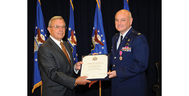
I had the honor of attending Colonel David Maddens’ retirement luncheon at the Space and Missile Systems Center (SMC) on Los Angeles Air Force Base (LAAFB) on June 16, and it was quite an event. Just prior to it, I asked Dave if he would like to conduct an exit interview after he took a short vacation with his family. He agreed it would be a good idea and a way to say some things he has wanted to say for awhile.
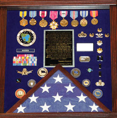
During the retirement luncheon, various people and organizations presented Dave with mementos of his time at the GPS Wing; I stopped counting at approximately 50 different presentations. This is an indication of the high regard in which Dave is held by those with whom he works on a daily basis. The military shadowbox he was presented (see photo), which is a typical military farewell presentation, had the following inscription, which is certainly not typical, and sums up the way those who work with Dave feel about him as a commander and as a person.
SHADOWBOX presented to Col. Madden on his retirement. The quote reads, in part,“The credit belongs to the man who is actually in the arena, whose face is marred by dust and sweat and blood, who strives valiantly, who errs and comes up short again and again, because there is no effort without error or shortcoming, but who knows the great enthusiasms, the great devotions, who spends himself for a worthy cause; who, at the best, knows, in the end, the triumph of high achievement, and who, at the worst, if he fails, at least he fails while daring greatly, so that his place shall never be with those cold and timid souls who knew neither victory nor defeat.” Theodore Roosevelt, 1910
“It is not the critic who counts: not the man who points out how the strong man stumbles or where the doer of deeds could have done better. The credit belongs to the man who is actually in the arena, whose face is marred by dust and sweat and blood, who strives valiantly, who errs and comes up short again and again, because there is no effort without error or shortcoming, but who knows the great enthusiasms, the great devotions, who spends himself for a worthy cause; who, at the best, knows, in the end, the triumph of high achievement, and who, at the worst, if he fails, at least he fails while daring greatly, so that his place shall never be with those cold and timid souls who knew neither victory nor defeat.”
Theodore Roosevelt
“Citizenship in a Republic,”
Speech at the Sorbonne, Paris, April 23, 1910
Dave was officially retired the next day by Colonel (USAF, retired) Bradford Parkinson. Dr. Parkinson was the first GPS Joint Program Office Director, in the early 1970s. He recently reviewed those early days and those responsible for the success of GPS with a two part series in the pages of GPS World.
Interview
Don Jewell (DJ): Dave, after almost four years first as the Vice Commander and then for the last three years the commander of the GPS Wing, of what are you most proud?
Colonel David Madden (DM): Overall, the GPS Wing has made significant progress over the years moving critical space system developments and acquisitions forward. The GPS Wing continues to lead with a “back-to-basics” foundation of rigorous system engineering, incorporated strategies like parallel risk reduction and capability insertion efforts, incremental delivery of timely and valuable capabilities to warfighters and civil users, and best business practices with solid cost estimates and contract incentives. Our new GPS III space vehicle, Next Generation Control Segment, and our GPS Modernized User Equipment programs incorporate our latest thinking of these innovations, and pave the path as a model for future acquisitions: low risk and high confidene associated with program execution (cost, schedule and technical performance).
The GPSW Team has had many specific accomplishments over the last four years. I would like to highlight just a few.
Space Segment. In the space segment, we accomplished a major milestone in GPS history with the launch of the final GPS IIR-M satellite in Aug 2009. GPS IIR-21 (M) marked a critical milestone in the GPS modernization program that was initiated in early 2000. The GPS IIR/IIR-M satellites are the cornerstone of the GPS constellation, and I expect them to perform well into the future. We’ve completed the development, testing and launch operations of the first GPS IIF Space Vehicle. The GPS IIF is the “Dawn of a New Era” of GPS services, providing new and improved capabilities that will continue to support not only the warfighter but commercial and civil users around the globe. IIF vehicles two and three will be delivered by early 2011, and two of the remaining nine fixed-priced vehicles are already proceeding down the Boeing Pulse Line.
Another noteworthy accomplishment was the award of the GPS III spacecraft contract. The GPS III will be developed in three increments with each increment to include more capabilities based on technical maturity. We successfully completed the GPS IIIA satellite Preliminary Design Review (PDR) in May 2009 and the GPS IIIA Critical Design Review (CDR) is scheduled for August 2010, two months ahead of schedule, which completes the detailed design and lays the foundation for fabrication. GPS IIIA is a back-to-basics spacecraft program with a strong focus on systems engineering, mission success, and acquisition excellence.
Ground Segment. In the GPS ground control segment, great lengths were taken to ensure the successful replacement of the decades-old command and control (C2) system with the new Architecture Evolution Plan (AEP) software, to improve GPS operator interfaces while providing a test capability for the new signals on the modernized satellites and to improve launch, anomaly, and disposal (LADO) operations. This new software will also provide robust security improvements to include “over-the-air” distribution (OTAD) of encryption keys to properly equipped military users.
I would also like to mention the successful award of the Next Generation Control Segment (OCX) back-to basics contract. The current acquisition strategy for fielding the OCX consists of four increments (commonly referred to as Blocks). The recently awarded OCX contract consists of Blocks one and two [while] Blocks three and four will be follow-on contracts that align with the future GPS IIIB and GPS IIIC spacecraft capabilities.
Colonel (USAF, retired) Bradford Parkinson congratulates Colonel Dave Madden on his fruitful career and retirement.
User Segment. In the GPS user equipment segment, we are actively working the development of a new generation of military user equipment to take advantage of the modernized M-Code [military only] signals. Currently we are conducting technical demonstrations and risk reduction for our next generation Military GPS User Equipment (MGUE) and defining a creative acquisition strategy.
USD-AT&L (the undersecretary of Defense for Acquisition, Technology and Logistics) signed an acquisition decision memorandum (ADM) on May 24, 2010, approving a material development decision for MGUE: the formal entry point for MGUE into the acquisition process. Currently, our three Military User Equipment (MUE) contractors are testing and delivering prototype cards this summer; government testing follows.
The foundation of our MGUE acquisition strategy is an incremental approach that leverages technology developed under the MUE program to move into engineering and manufacturing development of the first MGUE receivers as soon as possible. The strategy will be submitted to the Pentagon this summer after SMC coordination and PEO Space approval.
Our business strategy over the long term is to develop common GPS modules (CGMs) as the core engine for all DoD user equipment. We will develop CGMs incrementally as well, to support the form factors for the air, maritime, and ground domains. By early fall, we will have a final technical requirements document (TRD) for the MGUE form factors and CGM. We expect an RFP release in Feb 2011, and a Milestone A in May 2011. By early FY12, we should be on contract for Increment One of MGUE.
System Sustainment. From a systems sustainment standpoint, our GPS Wing detachment located at Peterson AFB has exceeded all expectation associated with ground (softwa
re and remote sites), user, and satellite systems sustainment. Even with all the system upgrades over the past year our sustainment team has kept the operational system performance well above the requirement: Read, no capability impact to civil or military users.
In fact, performance (availability, accuracy, and integrity) has been significantly improved over the last four years. Finally, they are normalizing sustainment of the current user equipment (DAGR-Defense Advanced GPS Receiver, MAGR-2K-Miniaturized Airborne GPS Receiver Version 2, and ADAP-Advanced Digital Antenna Production program) by transitioning sustainment responsibility to Air Force Material Command, specifically the Warner Robins Air Logistics Center depot at Robins AFB, Georgia.
Partnerships. The GPS Wing has established a close working relationship with Air Force Space Command Headquarters at Peterson AFB, Colorado for overall system operations, sustainment, and development responsibility; the 45th Space Wing (launch operations teams at Cape Canaveral Air Force Station in Florida), the 50th Space Wing (Overall System Operators at Schreiver AFB in Colorado), the Launch and Range Systems Wing (Los Angeles, California acquisition organization with responsibility for getting our GPS satellites successfully to orbit), the United Launch Alliance, the many government agencies (FAA, DOT, DOE, NSA, NGA, NASA, and so on), OSD organizations (PA&E, NII, AT&L, DOT&E), and our dedicated and professional prime contractors and major subcontractors to successfully sustain and enhance GPS mission capabilities — providing the highest overall daily system availability and the most robust GPS on-orbit constellation ever for war fighters and civil users worldwide. The constellation is healthier than it has ever been, and with the launch of the first IIF satellite and the on-track development of GPS IIIA, we are poised to maintain GPS as the gold standard for positioning, navigation, and timing well into the future.
The People. Finally and most importantly, I am proud of the men and women that make up the GPS Wing. They have molded many players (Aerospace, MITRE, service reps, international officers, government and civil agencies, SE&I and SETA (support) contractors, and U.S. Air Force military and civilians) into a finely tuned machine that is always focused on the number one priority: mission success. At the same time they have made the Wing a fun place to work. The GPS Wing members have made significant contributions to the quality of life in the GPSW, on LAAFB (Los Angeles Air Force Base), and the local community. Whether it was the great Company Grade Officer Association activities, tasty Tuesdays, the BBQs by the base gym, the holiday parties, the POW/MIA (Prisoner of War/Missing in Action) Run, the yearly toy contributions to the Marine Corp Toys for Tots program, regular food drives to support the Redondo Beach community, the yearly car show, the GPS Partnership Council, GPS University, or the many visits to local schools (just to name a few activities), they are truly a class act of which I was honored to be a small part.
DJ: Dave, how would you most like to be remembered?
DM: As the “AGER” guy. The one who put the enterprise back together, which will lead to better synchronization among the segments and ultimately deliver future warfighting capability to the U.S. and Allied forces. Senior AF, DoD, and Congressional leadership now look at GPSW execution as a enterprise rather than a collection of individual ACAT 1D (Acquisition Category 1D) programs. This has allowed the modernization program to move forward, significantly reducing the numbers of reviews, documents, and decision complexity.
DJ: Dave can you explain just where we are today in the ongoing GPS-IIF saga? Are we on track and on schedule to have IIF-1 activated sometime in late August? Will there be a second IIF launch this calendar year? Does Boeing finally have it all together?
DM: Don, I’m actually glad you asked the question that way, because it gives me an opportunity to address it squarely. It is completely fair to call the GPS IIF program a saga because of how long it took us to get to our first launch. But it is also important to ensure the credit and blame gets spread properly. The program did suffer from the sins of acquisition reform in the 1990s — on the government side and the industry side —- as well as major requirements changes years after program initiation. In hindsight, I’d have to say that we collectively failed again in the mid 2000s when we were overly optimistic about the time and funding needed for the challenges we would face in recovering from TSPR (Total System Performance Responsibility). On the flip side, during my tenure here I’ve had great support from my senior leadership — and from their Boeing counterparts — for taking the time necessary to ensure we have a quality program. We kept our eye on mission assurance and fixed quite a few end-of-life risks. We might not have had that luxury if the constellation weren’t so robust over the past few years.
In the end, the proof is in the on-orbit performance. So far, I’m proud to say that the checkout of SVN-62 has been proceeding very smoothly. My guys and Boeing have a great working relationship with the crews up at the 50th Space Wing, so the bird is in good hands. I expect we’ll find a few things we want to tweak before making the satellite available to users. Most space programs do that with the first satellite of a kind. In the end, the users will have a satellite that adds real benefit to the constellation performance.
Right now the teams are still pushing hard to get SV-2 ready to launch. There are still a few hurdles to clear, and the leadership needs to evaluate whether or not the constellation really needs another GPS IIF just yet or can it wait until next summer. I would love to watch another one go up this year, but it just won’t be the same watching from the sidelines!
DJ: I know it won’t be the same, Dave, but it should still be exciting. Now how about an update on the OCX program and how it is progressing?
DM: The OCX program is off to a great start. We awarded the contract to Raytheon in February 2010 and kicked off the integrated baseline review (IBR) in March. We are currently working side-by-side with Raytheon to solidify the program management baseline so we can jointly manage the program in a back-to-basics manner. Phase B software development for controlling modernized features is underway and builds on Phase A products, which we demonstrated with a prototype in December 2008. I have tremendous confidence that the OCX program will deliver promised capabilities on time to support modernized GPS.
DJ: Can you give us an update on where we are with the GPS IIIA program? Have you been successful in maintaining the no-changes mandate?
DM: GPS IIIA has maintained a stringent, back-to-basics approach since program inception. This has included significant investment in early systems engineering, and strict requirements discipline. To date, no new requirements have been levied on the GPS IIIA. Any new requirements for consideration are being addressed in future blocks as planned. The program is currently on track, and is forecasting the completion of Critical Design Review 60 days ahead of the baseline schedule.
DJ: We have satellites on orbit today that will reach their mean mission duration without broadcasting all resident signals or using all capabilities? Is there a plan to address this issue?
DM: Although there is some concern that the IIR-M satellites may reach their end of life before the L2C capability has been deployed, or that the IIF satellites may reach their end of life before L5 has gone operational, the concern is not justified by our reliability predictions and our current program plans. Current plans are for OCX Block 1 to provide L2C support, which is projected in the August 2015 timeframe, whereas the IIR-M satellites are expected to live well into the 2020 timeframe. Likewise, OCX Block 2 will provide L5 support in the 2016 timeframe, and our IIF satellites are expected to live into the 2025 timeframe. Therefore the likelihood that IIR-M or IIF satellites will be decommissioned before L2C or L5 have become operational, respectively, is very low.
Over the last couple of years, lots of discussion has gone into the integration issue, but I am not really sure what providing fully integrated GPS capability really means. What I do know is the user needs all three segments (satellite, ground command and control, and user equipment) to fully utilize new system capability. I also know that system integration comes in two forms. First and foremost from a technical design standpoint. This allows individual segments to be delivered independently but with high confidence the system will operate when all three elements arrive. This gives flexibility to the dynamics associated with budgets, policy decisions, requirements changes, unexpected technical hurdles, launch availability, and weapon platform availability for integration and testing (just to name a few variables). Rest assured the GPS enterprise is integrated at the technical level. However, it’s the second form of integration that gets all the attention: having all segments delivered in a reasonable proximity to each other. Not to make excuses, but as it relates to GPS, this is just hard to accomplish because it involves a span of control and accountability that is almost infinite. Many in the community recognize this reality, which has allowed the Air Force to set appropriate and realistic expectations so real capability can be delivered.
That being said, there are prudent things that can and are being done to speed the deployment of capability and set appropriate expectations. The most significant has been to broadcast the M-Code, L2C, and soon L5 signals from space to allow civil and military user equipment manufacturers to begin development and testing of their next generation of receivers. This gives industry a jump while the U.S. Air Force continues to develop the C2 capability and the next-generation signal monitoring capability (required to ensure signal in space performance integrity). Also, building the modernization programs with a strong mission assurance foundation is a major step forward. We understand the lessons learned that established the baseline for the current Block II systems delivery; the Block III systems are built on a solid acquisition strategy of reduced risk and increase execution confidence.
DJ: What do you see as one of the biggest GPS enterprise challenges, and what are some of your thoughts on the way ahead?
DM: That’s easy, Don: ensuring global PNT services are not interrupted as the United States continues to modernize GPS. If we don’t continue to develop a more robust means of ensuring user equipment compatibility, even a small number of non-system-compatible receivers (military or civilian) can significantly delay the delivery of critical modernized capability for everyone. Let me explain and provide some thoughts.
Since its initial design in the early 1970s, GPS has evolved in both capability and complexity. In the early days, systems engineering across the space, control, and user segments was relatively straightforward. The GPS Joint Program Office developed all military user equipment, and was able to rigorously ensure all specifications were verified prior to fielding. Over the past 20 years, however, GPS has become ubiquitous throughout the Department of Defense, with tailored satellite navigation solutions developed and acquired by dozens of program offices to support hundreds of unique requirements. Meanwhile, commercial GPS is one of the foundations of the Information Age, with GPS receivers produced in quantities approaching half a billion devices per year. The model of simply providing policies, standards, and interface control documents without providing a means to certify receiver compliance is becoming more challenging due to the continued growth in both military and civil applications for PNT, the competitive nature associated with user system applications and performance, and the increased complexity of GPS. Furthermore, it is especially difficult fielding upgrades to an established system like GPS while maintaining backwards compatibility with previously fielded equipment. These challenges are further exacerbated by difficulties associated with synchronizing the lengthy timelines associated with fielding ground-segment, satellite, and user equipment upgrades.
Recent highly isolated incidents, involving civilian and military receiver and other manufacturers, have highlighted the significant impact a very small number of receivers experiencing compatibility issues can have on the entire enterprise of worldwide users. In addition, a number of cases associated with improper receiver integration into major weapon systems have delayed system fielding as well not allowed the weapon system to best optimize GPS to the overall weapon systems performance.
Therefore, it is my opinion, to ensure worldwide PNT services are not interrupted as we continue to modernize the GPS, a more robust means of ensuring compatibility needs to be explored. (I would like to stop and make a note here: by “we” I mean all the DoD and civil agency stakeholders.) This means we need to not only continue to release “building codes” but we need to develop a capability to be more involved in the development, integration, and testing of new military and possibly civil user equipment.
We have recently taken a number of big steps in this direction.
First, we are currently significantly increasing the number of civil and military GPS receivers in our government testing labs. This will enable us to run tests against a wider variety of receivers, to gain higher confidence before we deploy system upgrades.
Second, we recognize that we need to ensure that our signal specifications, for both military and civil users, are as clear as we can make them. User-community representatives are already encouraged to be full participants in appropriate interface-control working groups. We further recognize that there is no substitute for thorough testing, and hence fully appreciate the importance of deploying signal-in-space capabilities as early as possible, on predictable schedules, so user equipment can be field-tested prior to market release or operational deployment.
Third, we are developing new upgrade fielding methodology whereby when we deploy system upgrades, we will take a more methodical approach and, whenever possible, field upgrades to smaller segments of receivers to prove compatibility without exposing all operational assets simultaneously. We will also apply a new software sustainment model to future military GPS user equipment, to ensure that inevitable system changes are systematically and rigorously executed with minimal impact on DOD programs.
Finally, we are investigating the establishment of something similar to an underwriters laboratory service to help support military programs with integrating GPS into their weapon systems during development. The teams associated with such lab services would support program design reviews as well as help develop the validation criteria for overall system acceptance. In addition, we are also starting discussions with key GPS civil receiver developers on how we might be able to provide a similar service to commercial receiver developers (potential fee-for-service type model).
Don, I highly recommend we continue to develop the four efforts I just mentioned but also dedicate significant time to critical thinking events to ensure we have minimized the risk of a widespread receiver issue, delays in delivering modernized capabilities, or sub-optimized weapon system performance. Manufacturers of equipment adversely affected by recent GPS upgrades have significantly stepped up their interactions with the GPS program office to resolve the compatibility issue and are playing a major role in providing an upgrade to their affected receivers to correct the issue. To date, no operational weapon systems have had to be grounded or civil capability degraded. I encourage the GPS community to treat recent events as a call to arms. GPS has become a critical national and international utility but it is much more complex than the electric or telephone services. How military or civil GPS receivers are designed, developed, and integrated into systems has a significant impact on the overall performance or lack of performance of the system. Don’t let recent events be a lesson not learned; let’s lead and solve the risk before it becomes an issue.
DJ: These are all excellent ideas, Dave, and many of them we have discussed in the past as concepts. It sounds like many of them are now a work in progress, but since you won’t be around to shepherd them into fruition, just what sort of prudent advice would you give Colonel Bernie Gruber as he assumes command of the GPS Wing?
DM: First and foremost, listen to your people — we have a great team! They are skilled professionals who really care about GPS. Second, keep the MGUE program focused and moving forward.
DJ: I certainly hope at a minimum that Bernie listens to your advice on MGUE. Now, Dave, when will the GPS Wing transition back to a Joint Program office, and what affect will this have on the military personnel working GPS? Will this re-designation be detrimental to their careers and future plans for the JPO? Will it lessen the GPS Wing’s/JPO’s influence in the GPS community and with other services?
DM: Don, we are scheduled to complete the transition and stand-up as the GPS Directorate on October 1, 2010. The Center is having one inactivation ceremony for all the Wings in SMC on September 8. The transition will be seamless and have a minimal effect on our military personnel. Our senior leadership is working on ensuring our materiel leader positions have group or squadron commander equivalency and will also be command-screened and boarded. There will not be very much difference within the Wing on a day-to-day basis. For the most part, the work, responsibility, and accountability will remain intact. The re-designation will have very little detriment upon the careers of the officers within the Wing. The officers’ records will show a transition and re-designation to explain the change, and that it is no cause of their own. As far as future plans for the organization, the strength of the leadership here in the Wing will still be in place and will be just as effective as it is now to lead each individual in our organization and to move forward and progress in GPS capabilities into the next era. Other services will still look to us to continue to forge advancements in GPS satellites so that our influence in the world’s GPS community will remain the standard: stronger than ever. Our organization will continue to acquire and sustain global navigation, positioning and timing services for our war fighters and civil users. We’ll still be the Green Monsters everyone knows and loves!
DJ: What message would you like to leave with our readers as you move on from GPS to the milsatcom community?
DM: GPS is in great hands. I look forward to the challenges ahead.
DJ: Any final comments, Dave?
DM: It has truly been a pleasure leading the GPS Team — my best job in 30 years of service. And you, Don, have also been a welcome friend.
GPS improves the quality of life for everyone on the planet. It saves lives both on the battlefield and in our cities and towns across the globe. The U.S Air Force and Air Force Space Command have been the diligent stewards of GPS since program inception in the 1970s and continue its commitment to this critical component of our national infrastructure. The current GPS constellation has the most satellites and the greatest capability ever. We are committed to maintaining our current level of service, as well as striving to improve service and capability through ongoing modernization efforts. The Air Force will continue to pursue an achievable path maintaining GPS as the premier provider of positioning, navigation and timing for military and civilian users around the world.
DJ: Dave, everyone at GPS World wishes you the best of luck in your future endeavors, and thank you for your honesty and candid responses to our inquiries through the years. You were the leader the GPS Wing needed for the last three plus years and you have left a legacy of which you can be justly proud. And in my opinion if the GPS Wing, Directorate or JPO thinks they have seen the last of Dave Madden, they should think again. Best of luck in milsatcom.
Our readers respond to the cover features in the April, May, and June issues: the two-part special the “Origins of GPS” and Richard Langley’s look at “GPS by the Numbers.”
Source: GPS World
Spilker and Parkinson: from GPS Origins to L5
Thank you so much, Brad, for the recognition you gave me in your history of GPS origins in the May and June issues.
I keep in my sometimes near photographic memory the numerous hours and trips we made over these many years, especially in the early days when you were Joint Program Director of GPS, the meetings we had with Bob Cooper and the Navy admirals. You
offered me the opportunity of a lifetime to contribute a little.
The one thing that you did not mention because of modesty is your ability to put together a team of Air Force officers so outstanding that I have not seen a comparable group anywhere else.
There is at least one other contribution worthy of inclusion, later in the program. One day during a board meeting at Stanford Telecom, I pointed out to Bill Perry that Congress had just zeroed out the GPS budget. He immediately got on the phone to the chairs of the House and Senate Armed Services Committee. Sam Nunn was chair for the Senate, and after much work and many calls, talked them into reversing that decision.
I have often thought that had the two parallel Navy Timation and Air Force 621B programs not been folded together as a single joint program, neither program would have survived.
On another subject, I think there is still work to be done on precision interoperability of multiple GNSS. How does it relate to “bounded inaccuracy” and integrity and precision positioning and carrier-phase precision?
Finally, many probably do not know it, and I have not received any recognition for it, but the work I did in designing the GPS L5 signal was performed as a gift to the U.S. Air Force, Federal Aviation Administration, and our country, with no compensation of any kind including my travel to the ION conference where I gave the award-wining L5 paper with AJ Van Dierendonck.
[See J. J. Spilker and A. J. Van Dierendonck, “Proposed New Civil GPS Signal at 1176.45 MHz,” Proceedings of ION GPS-99, Institute of Navigation, and an earlier, similar paper at the June 1999 ION Annual Meeting. — Ed. ]
Source: GPS World
I only mention it now because of the successful Block IIF launch. I ask nothing in return, and only hope it is of some value to our country and the world.
— Jim Spilker, Jr.
Half Moon Bay, California
Brad Parkinson replies:
Thanks to both you and AJ. It will be an outstanding addition to civil (and I hope military) options. Thanks also, of course, to the groups that ironed out the myriad of important details.
You also deserve credit for the initial work on split spectrum. Recall we suggested it for the civil signal to attain separation, and it was immediately endorsed and selected as the basis for the military L(M) signal.
— Brad Parkinson
Palo Alto, California
Selling GPS
Reading your two-part history of GPS origins recalled another story about those early years, and an influential Air Force officer.
Major General George Keegan was one of the most interesting people I met in my 35 years of Air Force civil service. Primarily an intelligence officer, he was considered one of the leading authorities on the Soviet Union, had been military attaché in the American Embassy in Moscow, and had just been given interim assignment as Director of Plans and Programs, HQ Air Force Logistics Command. He probably did not know anything about logistics, but he had a large staff to help him.
It was soon evident that he liked to come out to California, ostensibly to see his troops there (my office). What he really wanted was to go to the RAND Corporation in Santa Monica, the first non-profit brains factory set up in 1946 to guide the military services. RAND had a group of retired generals and admirals who war-gamed all sorts of scenarios to test various plans and to critique experiences leading to recommendations for changes. This was stimulating and valuable to him.
I was in charge of arranging his visits, and he was highly interested in the programs underway and especially in development at the Space and Missiles Systems Organization, where I worked. I would arrange briefings for him and occasionally drive him to our offices outside Norton Air Force Base near San Bernardino where the ballistic missile programs were developed.
We were collocated with the SAMSO Development Plans shop on the 4th floor of the Aerospace Corporation headquarters building when he called to set up a visit. He asked me what he had not been briefed on. I thought of one program, then called 621B, and told him it was a study area with a lot of promise. He asked me to set it up.
The “Program” was one lieutenant colonel in an office up the hall from us. He was managing several contracts to explore and develop the concepts for operation and conceptualize the hardware for development of what is widely known now as GPS.
The lieutenant colonel, whose name is lost to me, was not enthusiastic about briefing Gen. Keegan. I told him he was going to be on the Air Staff, he had security clearances for everything, and he would be smart to accommodate him. He agreed, but obviously reluctantly.
When General Keegan arrived, the lieutenant colonel started to describe the program as then projected. Gen. Keegan was obviously excited at what he was hearing, and he started throwing questions.
As a little background, knowing where you are precisely and being able to use that information is one of mankind’s oldest problems, and for the military forces, it is of the highest value. Among the many guidance systems in the inventory were Loran, OMEGA, TACAN, and many others. The annual costs to develop, maintain, improve, and operate these ran into hundreds of millions if not billions of dollars, and all of them operated with severe limitations.
General Keegan asked, if 621B were developed and deployed successfully, would it supplant and obviate the need for Loran? He got an extremely reluctant answer, yes. Would it replace TACAN? Same answer. OMEGA? Same answer.
I remember him sitting there staring at a very discomfited lieutenant colonel. He said, if I recall his words correctly, “Colonel, you don’t know what you have here. I don’t think you realize its importance. I will just have to sell it for you.” Later, when the General had left, the lieutenant colonel asked me if he was kidding. I replied that, from what I knew of him, he meant what he said.
Fast forward now about two years. General Keegan was the Intelligence Chief, HQ U.S. Air Force. Program 621B had progressed, had several people in the development planning process, and was ready to expand greatly if funding were provided by the Department of Defense. It was in competition with many other Air Force, Navy, and Army programs, and there wa
s no assurance that all would be approved.
At that time, possibly even today, there was an annual Department of Defense conference to allocate funds called the Defense Systems Acquisition Review Committee, or DSARC. Each agency presented its case. The 621B program chief was there (I now recall him to be Col. Parkinson, from reading the article), and he came to see us after the meeting in Washington. He was euphoric, and he wanted to know who General George Keegan was. I told him of the briefing I had arranged with his predecessor several years ago, and what Keegan had said. He said General Keegan had come through in spades.
This is second-hand reporting, but what happened was that before the DSARC began, General Keegan, who was not a member, asked the chairman for permission to address the group. What he said was something like this:
“Perhaps once in your lives, if you are extremely fortunate, you may have the opportunity to influence a development that may truly benefit your country. Today you have an opportunity to foster a program that will not only be of enormous value to all the armed services, but provide the answer to one of man’s oldest problems. Program 621B will give the military capabilities that will surpass anything ever imagined, and give the civilian world a spinoff of obvious immediate value and unlimited future potential. Whatever else is approved today, this program should be considered vital.”
The program director said General Keegan’s remarks were delivered with passion, and when he had finished and left their room, everyone looked at each other. He said their presentation was made easy — they were asked a lot of questions, and they had the opportunity to fully describe the timing, the impact, and the significance.
The result was they were not only fully funded, but they were told that if they could use more funds later, to let them know. He said after that speech, there was no question in anyone’s mind that there would be a wide open road for their program.
One of the rewards of my job in those years was being aware of and sometimes, in some way, involved in many fascinating events and programs. In this case, I inadvertently set in motion a chain of circumstances that, in a small way, may have facilitated the development of one of the most rewarding developments that came from the space and missile programs of the 1960s, ’70s, and ’80s.
I did not sell GPS, but, unknowingly, I helped.
— Don Hallwerck
Long Beach, California
Source: GPS World
Let Me Count the Waves
I read your publication with great delight but little understanding — with the possible exception of Mr. Langley’s contributions, especially “GPS by the Numbers” in the April issue. Fiddling with my calculator years ago, I quickly found pi to eight digits using 355/113. Do you suppose Mr. Langley has a better simple m/n?
— John Woodcock
Bellevue, Washington
Richard Langley replies:
Thanks for your message and kind words about GPS World. Fraction approximations to pi is an interesting topic, one that I didn’t have much room to write about in the numbers article. Your use of 355/113 as a good approximation for pi is one that has been known for awhile. It was first discovered by the Chinese mathematician, Zu Chongzhi in 480 A.D. It is good to seven digits. You need more than an 8-digit calculator to show this, though. Type 355/113 into the Google searchbox to get an answer to 9 digits and you’ll see that only the first 7 are valid. It’s somewhat more complicated, but the fraction 103993/33102 gives pi to 10 digits. These fractions can be derived from the continued fraction representation of pi. For a discussion of that and many other interesting facts about pi, see Wikipedia.
I have received the latest issue of GPS World. What a remarkable accomplishment! An outstanding example of sustainability, commitment, impact, and excellence! The Innovation column has constantly been a source of inspiration and ideas for all, not least GNSS students around the world.
If ever you have the chance to collate them in one single pdf file and put it on your website or/and that of GPS World, this would be a most valuable contribution and worth more than many books on the subject I can think of!
Congratulations, and may we see you on the front page for the 300th column!
— Gerard Lachapelle
University of Calgary, Canada
Just read your “Numbers” article. I enjoyed it very much, especially because I am writing java code for an SDR-GPS-receiver I am building. As a starter I am trying to decode Kai Borre’s data file. I just finished implementing parallel code search using FFT. Gives remarkable insight in DSP. I am a retired engineer and radio amateur PA1KDG. Keep on writing and I’ll keep on reading — promise.
— Kees de Groot
Wageningen, The Netherlands
Richard Langley replies:
Many thanks for your message and interest in the GPS World Innovation column. Coincidentally, one of my students has just finished up a Ph.D. project on designing a strategy for implementing a SDR-GPS receiver and presented his results in April. Good luck with your project.
By Bradford W. Parkinson and Stephen T. Powers, with Gaylord Green, Hugo Fruehauf, Brock Strom, Steve Gilbert, Walt Melton, Bill Huston, Ed Martin, James Spilker, Fran Natali, Joe Strada, Burt Glazer, Dick Schwartz, Len Jacobson, AJ Van Dierendonck, and others.
GPS Phase I program approval meant that the real work could begin. The conclusion of a two-part history, told by the people who made it.
By January 1974, the GPS program at the Joint Program Office (JPO) was well underway. With only about 30 officers, the workload was enormous. Fortunately, the Aerospace cadre of about 25 also made extraordinary contributions. In a flurry of activity, the team developed requests for proposals, made top-level specifications, and published initial interface control documents. The work of converting viewgraphs into real hardware, as many know, is an exacting and sometimes painful process.
Of course there were many challenges, but five of them, principally engineering, stand out as particularly daunting. These were:
Defining the specific details of the GPS CDMA signal structure;
Achieving rapid and accurate satellite orbit prediction;
Ensuring and demonstrating spacecraft longevity approaching ten years;
Developing a full family of GPS user equipment.
We discuss each challenge in detail, including the names of those most instrumental in meeting them. The first appearances of their names are highlighted, although if they appeared in Part 1 of this story (May 2010 issue), their names are not highlighted.
EARLY GPS MANPACK worn by JPO Army deputy Lt. Col. Paul Weber. This photo graced the cover of the first-ever GPS brochure! (Credit: Bradford W. Parkinson and Stephen T. Powers)
Challenge 1.Defining the specific details of the GPS CDMA signal structure (coherence, acquisition, spreading, communication protocol, structure, error correction, message structure, and so on).
The selection of the GPS signal structure was broadly confirmed with the tests that were run by program 621B at the White Sands Missile Range with the help of Joe Clifford, Bill Fees, and Larry Hagerman, all from the Aerospace Corporation.
While the fundamental decision to select CDMA had been made during the Lonely Halls meeting, a vast number of details had yet to be worked out. Fortunately, there were many earlier studies of the signal. Dr. Jim Spilker (then of Philco Ford), who had also written the major reference book on digital communications, authored one of the studies. Dr. Charles Cahn, Nat Natali, Burt Glazer, Ed Martin, and Dr. Robert Gold of Magnavox all made significant contributions. One of the most important details was the decision that the carrier, code, and data of the GPS signal would all be phase-coherent (Figure 1). As discussed later, this decision enabled much of the precision that we now see in advanced GPS receivers.
FIGURE 1. GPS signals were designed to be all aligned as transmitted, that is, coherent. (Courtesy Misra and Enge, Global Positioning System).
The exact Gold codes family had to be selected from the original family, since Dr. Gold’s technique did not include the natural Doppler shifts. The data message was integrated into both the civil (C/A ) and military (P/Y) signals through inversion of their codes every 20 milliseconds.
To work out the details of the data message, the JPO had a strong team including Major Mel Birnbaum, Col. Brock Strom, and Capt. Bob Rennard. Outside contractors making major contributions included Dr. Fran Natali, Dr. A. J. Van Dierendonck, and others. Van Dierendonck played a particularly effective role in helping define “GPS time.” This sounds rather mundane, but had some very interesting complexity. Jim Spilker recommended the 1023-bit message length to avoid a correlation problem associated with Doppler shifts (this recommendation was incorrectly attributed in the last issue).
The data stream came down at 50 bits per second. Through this tiny pipe of information, all the precision of GPS had to pass. It included the space-vehicle orbit-position information (ephemerides), system time, space-vehicle clock-prediction data, transmitter status information, and C/A signal handover time to the P/Y code. Also as a part of the message, ionospheric-propagation delay models were incorporated for the single-frequency user. Further, to aid rapid acquisition of new satellites just rising over the horizon, the ephemerides of all other satellites in the full constellation had to be included. Each digital word had to be defined in terms of scaling, bias offset, and precision in terms of the number of bits transmitted.
About 95 percent of the GPS message has endured with no changes needed at all. In a few cases, because the newer user equipment is more accurate, greater precision is desirable. It is a great tribute to the brilliant engineers and scientists who designed the signal structure in 1975 that it has endured for 35 years with so little need for modification.
Some of the JPO Heroes at a “dining-in,” a recognition dinner. From left, Major Mel Birnbaum (made many important contributions. He was famous for marathon code reviews that could last 18 hours straight. He hated to miss schedules!); Col. Don Henderson (later Maj. Gen.) second Air Force deputy; Major Ralph Tourino (later Maj. Gen.), Program Control; Lt. Col. Ken Juvette. director of procurement; and LCdr. Joe Strada, a key leader in the extensive test program. (Credit: Bradford W. Parkinson and Stephen T. Powers)Credit: Bradford W. Parkinson and Stephen T. Powers
Challenge 2. Developing space-hardened, long-life, atomic clocks (qualified for the upper Van Allen Belt, with 4- to 5-year lifetime requirement for individual clocks).
In 1966, both the Air Force and the Navy recognized that developing a precise, stable time-base for generating the one-way (passive) navigation ranging signal in the satellite was essential. Cesium atomic clocks had been invented, demonstrated, and offered for commercial sale by the middle of the 1950s, before the Space Age. The major commercial issues with these clocks were that they tended to be bulky, power-hungry, and not hardened against space radiation. To address that problem, rubidium atomic clocks, noteworthy for their small size and low power requirements, were developed. Still, the issues of mechanical and radiation hardening as well as temperature sensitivity had to be resolved before they could be used in space.
The 621B/Woodford/Nakamura study of 1964/66 called for atomic clocks in the satellites in at least seven places. The study advocated a technology program to space-harden existing clock technology. Unfortunately, the Air Force chose not to pursue a space atomic-clock technology program.
However, the Naval Research Laboratory (NRL) did institute a program in 1964. It pursued the technology for stable clocks with a series of satellites that have already been discussed. The first Timation satellite, launched in May 1967, carried a quartz clock. Not surprisingly, the frequency varied substantially with satellite temperature. The second Timation satellite also contained a quartz clock as well as a temperature controller and showed improved operation, but the results still fell short of those necessary for a GPS satellite. The third satellite in the series had not been launched before the Pentagon approved GPS development in December 1973. In any case, Timation 3 was designed to carry two slightly upgraded, off-the-shelf commercial rubidium clocks.
Qualification Model of the first GPS atomic clock, built by Rockwell International working directly with Efratom, a small German company. (Credit: Bradford W. Parkinson and Stephen T. Powers)
Based on the progress that NRL had made, during the Lonely Halls meeting the JPO decided to commit to atomic clocks in the first operational GPS satellites. This third Timation satellite was renamed NTS-I and came under the newly formed Joint Program Office for GPS. The satellite was launched on July 14, 1974, as a part of the GPS program. However, the ineffective attitude-stabilization system caused varying sun angles and hence, significantly varying temperatures, masking any careful evaluation of the rubidium performance.
The GPS space-based rubidium atomic clock technology was derived from a unit produced by Efratom, a small company initially based in Germany. The geniuses behind this creative device were Ernst Jechart and Gerhard Huebner.
By the summer of 1974, a satellite contractor, Rockwell International (RI), had been selected to build the GPS operational satellites. Included in the program direction by the JPO was a separate development of rubidium clocks for the satellites as an alternative to the NRL cesium clock effort, in case the NRL effort faltered. Hugo Fruehauf of Rockwell had independently discovered and contacted Efratom, the company that NRL was working with, although his interaction was totally independent of that of the NRL. In addition, Fruehauf’s relationship with Efratom was simplified because of his fluency in German, since Jechart did not speak English, and Efratom had just established an office in Southern California near the Rockwell developers. Figure 2, a page from the original Rockwell proposal, shows the excellent ground test data at both 1000 seconds and at 24 hours.
Figure 2. Test results for the Rockwell proposed GPS space-hardened prototype atomic (rubidium) clock, based on the Efratom commercial clocks. (Credit: Bradford W. Parkinson and Stephen T. Powers)
On realizing that the small Efratom company would be incapable of producing a radiation-hardened, space-qualified rubidium oscillator, RI’s GPS satellite program manager Richard Schwartz created a teaming relationship with them, which included his chief engineer, Hugo Fruehauf, plus Dale Ringer, Dr. Chuck Wheatley of Rockwell’s Autonetics Division, and Efratom’s Werner Weidemann. With heroic efforts, this team built a space-qualified clock in time for the first GPS launch in February 1978.
Meanwhile, the NRL-sponsored development of a cesium clock by FTS ran somewhat behind schedule. Their cesium clock was not available for the first three GPS satellite launches. The first NRL hardened clock was included on the fourth GPS satellite; unfortunately that unit failed after 12 hours of operation because of a power-supply problem. As a result, the only operating clocks on the first four GPS satellites were those developed by the Joint Program Office through its contractor Rockwell International. The decision to proceed to full-scale development for GPS, called DSARC 2, was made before any NRL-developed clocks had become operational.
That said, the NRL-sponsored FTS cesium clocks were available for later satellites, and performed extremely well. Later Block II GPS satellites carried two rubidium-frequency standards made by Rockwell and two cesium-frequency standards (primary source, Frequency and Time Systems; secondary sources, Kernco and Frequency Electronics Inc., on selected vehicles). Figure 3 summarizes the early clock program.
Figure 3. Earliest satellite-clock technology developments, culminating in the last row: four Rockwell satellites with Rockwell-developed rubidium clocks. (Credit: Bradford W. Parkinson and Stephen T. Powers)
In spite of NRL’s development difficulties, GPS users owe a debt to the lab for its pursuit of this technology. Clearly GPS would not have performed so well without space-hardened atomic clocks. It was the apparent NRL progress that strengthened the argument. The support of Ron Beard of NRL in this joint effort has been invaluable to the program over many years. More than 450 atomic frequency standards have now flown in space. By far the greatest user has been GPS.
Challenge 3.Achieving rapid and accurate satellite orbit prediction, to within a few meters of user ranging error (URE) after 90,000 miles of travel.
Since the GPS system architecture had upload stations only on U.S. soil, the satellites were out of sight for many hours, making accurate prediction of their orbits essential. To achieve the expected positioning accuracy, the orbit prediction had to contribute less than a few meters of ranging error after 90,000 miles of travel. Achieving this standard was a major challenge in the early days of GPS. Such a prediction must account for the complications of Earth pole wander, Earth tides, general and special relativity, the noon turn maneuver of the satellite, solar and Earth radiation, and the reference station’s location. Figure 4 gives an example of the problems of polar wander.With roughly a 400-day period, this effect had an amplitude of many tens of feet. While this wander has to be included in the GPS orbit-prediction model, fortunately GPS is the major technique to measure it.
Another, usually unrecognized feature is that the monitor stations only use the GPS signal for ranging. In other words, they are passive, rather than using the usual technique of that era, two-way ranging. The reference receivers were of a special design, developed by Jim Spilker’s company, STI. They successfully received the first signal from the Rockwell/ITT satellite (NDS-1) on March 5, 1978, after its launch on February 22, 1978.
Fortunately, the Transit program had pioneered precise orbit prediction and had taken these effects into account. Its Astro/Celeste program, developed by Bob Hill and Dick Anderle at the Naval Surface Weapons Center in Dahlgren, Virginia, batch-processed the measurements taken by the reference stations. Unfortunately, this processing would take too long to provide the most up-to-date predictions.
A new scheme was devised that included partial derivatives of prediction relative to reference-station measurements. A.J. Van Dierendonck applied his knowledge of filters to help lead development of these calculations, which allowed a modified (linearized) Kalman filter to be used for near-real-time optimal prediction. Bill Fees of Aerospace, Walt Melton of General Dynamics, and Sherm Francisco of IBM, among others, implemented these techniques. The initial master control and upload stations were located at Vandenberg Air Force Base, since moved to Schriever Air Force Station; a backup master control station has been re-established at Vandenberg.
Figure 4. Motion of the Earth’s spin axis must be included in the measurement parameters for GPS satellite location. The broadcast ephemeris is adjusted to include this effect, so the user need not make further adjustments. (Courtesy of International Earth Rotation and Reference Service). (Credit: Bradford W. Parkinson and Stephen T. Powers)
Challenge 4.Ensuring and demonstrating spacecraft longevity approaching 10 years (the issue was GPS affordability)
The issue was simply that sustaining a constellation of 24 satellites would be prohibitively expensive if the satellites did not have long lives. Again, the Air Force/621B study by Woodford and Nakamura in 1966 focused on the problem: “The most specific change in satellite technology is the increase of mean time before failure (MTBF). MTBFs on the order of 3 to 5 years can now be considered feasible.”
The problem is easily illustrated in Figure 5. The light blue line shows the trade-off between average satellite lifetime, L, and the required number of satellites per year for a 24-satellite constellation. GLONASS, the Russian system competing with GPS, has the experience shown in the upper white box. With satellite lifetimes averaging two to three years (or less), GLONASS has a corresponding requirement for eight to 12 satellite launches per year. Only a very wealthy country can sustain such a launch program.
Figure 5. The imperative for long satellite lifetimes. (Credit: Bradford W. Parkinson and Stephen T. Powers)
The red oblong illustrates the U.S. GPS experience, which requires only two to three launches per year. Also shown is the initial experience of GPS during Phase I. The first 10 GPS satellites reached an average age of 7.6 years, with #3 and #10 exceeding 9 years. This is an enormous credit to Rockwell International and in particular the program manager Richard Schwartz. He had excellent system engineering support from Andy Codik. The JPO satellite division was intially led by Major Gaylord Green and later by Maj. Doug Smith, with help from Capt. Jack Henry.
Three factors are key to long-lived satellites:
Designs with carefully selected redundancy (for example, clocks, power amplifiers),
Enforcing a rigorous part-selection program including the de-rating of parts (must be class S. or equivalent),
Testing as you fly and insisting on a detailed analysis of all failures.
Figure 5 also illustrates why the Timation clocks could not be used as prototypes for the GPS program. In general, their maximum lifetimes were approximately one year. Clearly their designs needed greater maturation.
The demonstrated lifetimes were essential to passing the next milestone, DSARC II, which allowed GPS to proceed to full-scale development.
Challenge 5.Developing a full family of GPS user equipment that capitalized on the digital signal (leading to inexpensive digital implementation) and spanned most fundamental military uses, as well as demonstrating civilian cost feasibility.
The last, but certainly equally difficult of these five engineering challenges, was the development of nine different types of GPS user equipment. Recognize that a major part of the challenge was to stuff the real-time digital software processing into the relatively primitive digital computers of that era. Table 1 summarizes the development of user equipment:
Data: Bradford W. Parkinson and Stephen T. Powers
All of the sets performed well within specification. They were characterized, however, by large size and heavy power demands. Magnavox, under the technical direction of Vito Calbi, produced the largest variety of user equipment. It was a subcontractor to General Dynamics, who reported directly to the JPO. At Aerospace, Frank Butterfield was a gifted contributor, particularly skilled at practical antenna design.
The Generalized Development Model (GDM) reciever, developed by Rockwell Collins Group, was the largest of the sets, created for a specific purpose: to demonstrate the ultimate jam resistance for GPS user equipment. It attained performance better than 100 db jamming-to-signals ratio (J./S) in actual flight test. The GDM receiver achieved this by integration with inertial components, directional antennas, and shading with the aircraft body. Such a receiver can fly directly over a 1 kW jammer at 4,000 feet and not be affected. The original GDM program manager at the USAF Avionics Lab was Maj. Roger Brandt.
The Rockwell Collins Generalized Development Receiver (GDM). This advanced receiver achieved more than 100 dB of anti-jam in actual flight tests. (Credit: Bradford W. Parkinson and Stephen T. Powers)
The single-channel manpacks were large and clumsy, but they operated very well. The payoff created by the CDMA signal is illustrated with the 12-channel, single-chip modern implementation, shown in the bottom picture. This contemporary chip’s accuracy is much better than any of the equipment produced during Phase I.
Developing test environment and analysis setup was almost as challenging as the user equipment. Lt. Col. Val Denninger, Maj. Darwin Abbey, and Lt. Cdr. Joe Strada led this very successful effort. While most testing took place at Yuma Proving Ground, test sites were also located in San Diego and elsewhere.
Left: 1978 single-channel (sequential) Manpacks, two types by Magnavox and Texas instruments. Batteries alone weighed much more than current military handsets. Right: The second JPO deputy, Col. Don Henderson (left), and Aerospace program manger Ed Lassiter (right). Bottom: A modern 12-channel (parallel) Atheros chip receiver with more capability. (Credit: Bradford W. Parkinson and Stephen T. Powers)
The Most Fundamental GPS Innovation
The CDMA (spread-spectrum or PRN) modulation used for passive ranging is clearly the most fundamental innovation of GPS. This signal enabled four-dimensional positioning for the user without requiring an atomic clock in the user equipment. The Russian GLONASS (the other, partially-operational global navigation satellite system) also used spread-spectrum passive ranging, but resorted to a frequency-separation scheme (FDMA, frequency-division multiple-access) that has proven inferior in actual use.
The innovative design of this CDMA signal has enabled all of today’s precision applications for GPS. It is currently common for inexpensive GPS receivers to simultaneously receive signals from more than 10 satellites, yet all of these signals are being broadcast on exactly the same frequency. In fact, the number of signals that can be received is virtually unlimited using the spread-spectrum CDMA approach. Using a routine processing algorithm, the user, receiving more than four signals, has an instantaneous position that is more accurate than that using four satellites alone. This robustness includes a technique to ensure integrity of the GPS solution. The method, called receiver-autonomous integrity monitoring (RAIM), isolates a rogue satellite that is not operating properly, to ensure integrity of the GPS solution.
Another technique, called carrier tracking, is enabled with the coherence of the code and the carrier broadcast in this signal. When coupled with some form of differential GPS operation, the result is relative positioning accuracy that is unprecedented — frequently better than a millimeter. For example, surveyors can now routinely resolve three-dimensional position to this accuracy. Even common user equipment can make use of the coherence of the signal. The receiver accomplishes this by employing the so-called Hatch/Eschenbach filter that uses the reconstructed carrier signal to smooth the code-transition measurement that greatly decreases the noise of the raw code measurement.
The processing gain in the GPS CDMA signal has been enhanced by deep integration with inertial navigation components. This has enabled the demonstrations of very high interference rejection by such receivers. DaleKlein and Ed Copps of Intermetrics Corp. were major contributor
s to the integration of GPS with inertial measurement units for the Magnavox high-performance military receivers.
Side-Tone Ranging. The competing side-tone ranging signal structure offered by NRL in the 1970 Easton patent had a fundamental flaw. If the signals were broadcast at the same frequency, they would interfere with each other. On the other hand, if they were broadcast on different frequencies, the user equipment would require a separate analog front end and tracking loops for each signal. In addition, each channel would have its own time-delay bias that would probably vary with temperature of the user equipment. A study by Magnavox also noted that the side-tone ranging signal could be easily spoofed; it was not clear how to encrypt such a signal. The final problem was that the signal was fundamentally an analog type and would have not been able to take advantage of modern digital signal processing. As a result, the receivers would be more complex and expensive.
The Air Force 621B/Aerospace and Magnavox studied the CDMA signal structure extensively after the 621B Woodford/Nakamura study was completed in 1966. Bob Gold of Magnavox had, in 1967, invented the technique to select acquisition codes that were mathematically guaranteed to not look alike (were uncorrelated). Early in the program, the JPO hired Dr. Jim Spilker, a recognized worldwide authority on digital signal processing, to contribute to this effort. Another worldwide expert, Charlie Cahn of Magnavox, was also a major contributor to the signal design. As mentioned previously, the details of the signal required the efforts of many people.
By 1969, the CDMA signal was being used in many communication applications. Adapting this signal for navigation raised the questions that were posed in an earlier section. It is hard to believe today the issues surrounding its use had to be addressed in 1970. It is to the great credit of Program 621B that it built the receivers and ran the series of tests at White Sands Missile Range that had earlier resolved all the major issues surrounding the signal structure. This irrefutable evidence allowed the JPO team to confidently choose this signal during the Lonely Halls meeting in September 1973. Great credit must go to Bill Feess who worked tirelessly to complete the analysis that demonstrated 5-meter accuracy in those White Sands tests.
CDMA-Enabled Applications
The distinction between the Timation side-tone ranging and the 621B CDMA signal is critical to understanding the origins of GPS. The Air Force CDMA signal was different in essential and fundamental ways from the Easton side-tone ranging modulation. Three examples of precise three-dimensional applications, not achievable with side-tone ranging, illustrate the subsequent success of the 621B digital CDMA signal.
Aircraft Blind Landing. In 1992, the Federal Aviation Administration (FAA) sponsored Stanford’s development and demonstration of the first Category III (blind landing) system in a commercial aircraft; the effort was led by Clark Cohen and developed by a group of Stanford students under the supervision of Brad Parkinson. The only sensor for both position and attitude was GPS. The carrier-tracking receiver was a derivative of a Trimble receiver; it relied on the CDMA signal structure for both accuracy and integrity. (See Figure 6.)
Figure 6. Results of first blind landing tests using GPS alone, 110 landings with a commercial Boeing 737. (Credit: Bradford W. Parkinson and Stephen T. Powers)
Robotic Farm Tractor. Using similar technology, a different group of Stanford students in the same lab demonstrated the first precision GPS-controlled robotic farm tracker. Again, the capability was enabled by the GPS CDMA signal. The John Deere Company sponsored this effort, which has now expanded into a worldwide market of more than $400 million per year.
Robotic farm tractor developed at Stanford with support from John Deere company. Student leader Mike O’Connor and colleague Tom BeLl shown. Tracking test at 5 meters/second, with worst error around 3 inches! Now a $400M/year market. (Credit: Bradford W. Parkinson and Stephen T. Powers)
Earth Crustal Monitoring. A third example of the power of the CDMA signal is precise survey, focused on Earth movement and crustal tracking (Figure 7). The original GPS surveying receivers were pioneered by PhilWard at Texas Instruments and Charlie Trimble at Trimble Navigation, among others.
Figure 7. Continuous observation of earth crustal motion with a precision of better than a millimeter: distributed slip on Kilauea volcano, Hawaii. (Credit: Bradford W. Parkinson and Stephen T. Powers)
Summary. Many technologies came together to make GPS operational, none more revolutionary than the signal structure demonstrated by 621B at White Sands, and selected by Parkinson during the Lonely Halls meeting. Virtually all high-precision uses of GPS depend on the characteristics of this signal.
Credit: Bradford W. Parkinson and Stephen T. Powers
More on GPS Origins
The fundamental basis for the GPS design was clearly the Woodford/Nakamura and subsequent studies undertaken by 621B, not the system outlined by NRL in the Easton patent. More than 500 million current users have overwhelmingly confirmed the value of the selected technique using a minimum of four-satellite passive ranges and the CDMA signal. If each GPS user had to employ an atomic clock, the price of most GPS receivers would be prohibitive. The value of a four-dimensional solution for users has also been irrefutable. Had GPS followed the blueprint of the NRL patent, it is reasonable to say that almost all system uses, military as well as civilian, would have been fatally compromised. Further, had the Easton side-tone ranging signal been selected, broadcasting 30 satellites on the same frequency, as GPS does today, would have created an undecipherable electromagnetic jumble.
Summarizing Easton’s Patent. We earlier mentioned the NRL/Easton patent for the Timation design. It is important to summarize that invention and its relationship to the actual GPS design. A few people have written that Roger Easton “invented” GPS. As stated, Easton did have a competing concept that he had developed at NRL. In October 1970, four years after the completion of the secret, seminal system study by Woodford and Nakamura, Easton applied for a patent, “Navigation System Using Satellites and Passive Ranging Techniques,” that was granted on January 29, 1974 (U.S. 3,789,409). A careful reading of the patent, available on the web, reveals the following:
The technique described by Easton clearly calls for a synchronized “extremely stable oscillator” at the user station. Elsewhere he states: “would typically be controlled by an atomic clock.” This less-capable method of navigating was examined in the Woodford/Nakamura study, four years before Easton’s patent application, and is definitely not the technique chosen by GPS.
The patent advocates the use of a passive ranging technique, whose description occupies most of the patent, with multiple frequency tones, not the CDMA technique of GPS that had already been studied by 621B. Before the patent was issued, 621B had already built prototype GPS CDMA receivers, flown them at the White Sands range, and demonstrated three-dimensional accuracies of about 5 meters. The Easton passive-ranging technique, commonly called side-tone ranging (STR), had been included in a 621B analysis of alternatives. STR was rejected because of poor resistance to interference or spoofing, and the inab
ility to broadcast all satellites at the same frequency without destructive self-interference.
Both the description and the accompanying diagram in the patent clearly refer to two-dimensional navigation, using lines of position. To extend this to three or four dimensions was not mentioned. Such extension would probably only be possible if the satellites all broadcast on different frequencies, which would have made extremely high-precision positioning (as attained by the actual GPS design) infeasible.
Thus, it is correct to state that the Easton patent did not, in any way, represent the actual GPS design in at least these three fundamental aspects.
Further Transit Contribution. In 1974, after the first phase of GPS had been approved, the Transit program requested funds to upgrade the Transit signal structure to the same passive ranging technique (CDMA) being planned for GPS. The program’s purpose was to use Transit signals to track Trident missile testing launches in broad ocean areas. Air Force Col. Bradford Parkinson (director of the GPS Program), Dr. James Spilker (Stanford Telecommunications Inc.), and Jack Klobuchar (Air Force Cambridge Research Laboratory) responded with a technique for substituting GPS signals, with a translated frequency relayed to the ground to track those missile tests.
After three Pentagon briefings on the proposed alternative technique, Dr. Bob Cooper of the DoD concluded that the GPS signal would be used. Included was a decision to add two more satellites to the Phase I development of GPS to accommodate the Trident launch window. As a result, $66 million was transferred from the Navy to the USAF GPS program. The benefit to the fledgling GPS program was enormous. This greatly expanded the test time for GPS, and also reduced the risk, since no spare satellites had been approved for the program. While the Trident program was somewhat unhappy with the loss of funds and control, it immediately unleashed the creativity of Johns Hopkins University Applied Physics Laboratory and successfully met the Trident missile test tracking requirements.
GPS JPO Innovations
GPS was the first DoD program directed to be managed as a Joint Service Development Program. This new approach, conceived by Dr. Currie, led the GPS program to be designated a JPO or Joint Program Office. As a result, there were deputy program managers assigned from the Navy (Cdr. Bill Huston), Army (Lt. Col. Paul Weber), Marine Corps (Lt. Col. Jack Barry), and Defense Mapping Agency (Paul Frey), as well as the customary Air Force deputy (initially Lt. Col. Steve Gilbert, later Lt. Col. Don Henderson). Rather than use these well-qualified people from other services simply as liaisons, they were each assigned specific programmatic responsibilities.
At the first major program review at Andrews Air Force Base, Parkinson called the convening general’s attention to the fact that he was leading a joint program, and with the general’s indulgence he had invited his deputies from the other services to attend. Since attendance by other services at Air Force program reviews was unheard of, this drew a gasp from the roughly 200 Air Force officers attending. The JPO approach truly broke new ground in intra-service cooperation.
At the JPO. Frank Butterfield of Aerospace, Col. Parkinson, and Cdr. Bill Huston, deputy JPO director from the U.S. Navy, in the early 1970s. A model of a Phase I GPS satellite stands on the table between the latter two. (Credit: Bradford W. Parkinson and Stephen T. Powers)
Parkinson had entreated the Federal Aviation Administration to also send a deputy. The public response by the FAA deputy administrator for development was: “We don’t want GPS, we don’t need GPS, and if it is ever deployed, we will never use it.” Throughout this period, Glen Gilbert (sometimes called “the father of air traffic control”) was a strong and early advocate for FAA use of GPS. It took many years for the FAA to accept his views. Obviously times change; the current relationship between the FAA and the GPS Program Office is excellent, fostered by Col. Dave Madden and his FAA counterpart Leo Eldredge.
JPO as Prime Contractor. The JPO cadre served as the prime or integrating activity for the whole program. Gen. Schultz almost fired Parkinson when he proposed this. The general had expected him to hire a separate commercial integrating contractor. After Parkinson explained that the major interfaces between the three segments — satellite, ground control, and user equipment — were the signals, Gen. Schultz acceded to the plan. This pioneering aspect was critical because it ensured that all aspects of the system would be under the direct purview and control of the JPO.
Award and Incentive Fees. The use of innovative procurement awards for the contractors was very new in DoD in 1974. Beginning with the satellite contract, the JPO made extensive use of new forms of positive rewards for the contractor, including incentives for on-orbit performance. Gaylord Green pioneered this activity with skills developed as a project officer in the Advanced Ballistic ReEntry Systems Program (ABRES) program office. Incentives were applied to virtually all the other contracts as well, and seemed to have a very positive effect.
Normally the Space and Missile Systems Organization (SAMSO) procurement office, which was independent of the JPO, would have been reluctant to approve such radical new ideas. Fortunately, Parkinson carpooled with another colonel who was head of SAMSO procurement and a breath of fresh air. This attitude was exemplified by a sign at eye level as you left the procurement director’s office: “Nothing would be done at all if a man waited until he could do it so well that no one could find fault with it.” (It turns out this came from remarks by Cardinal John Henry Newman.) With that attitude, the SAMSO office approved almost all of the JPO’s “wild” procurement innovations. Many of these innovations are now routine.
Changes. The Air Force provided a high-level spec for the satellite that defined the signal structure, the power on the ground, the frequencies, the orbit, and the amount of weight the booster could put into that orbit at apogee. The JPO left it up to the contractor to design a satellite that could meet those requirements. The key point is the JPO never changed the requirements, which kept GPS on course with minimum cost increases for the devlopment.
Refurbished Atlas F Booster. Today, up to half the cost of a satellite on-orbit is the cost of the booster to place it there. While the costs were perhaps not proportionally so large in 1977, they still could consume large pieces of a program’s budget. Luckily, the United States had mothballed much of its liquid-fuel ballistic missile force during that period. The JPO chose to use refurbished Atlas Fs as boosters, saving many millions of dollars. Some have suggested this idea originated with NRL. While NRL may have also been using them, both Parkinson and Green came from the ABRES program where refurbished Atlas Fs were already employed. Thus, the decision made in the Lonely Halls meeting was based on knowledge the JPO already had, which included additional steps the ABRES had taken to improve the reliability of the booster. (See Figure 8).
Figure 8. Refurbished Atlas-F booster characteristics. Col. Parkinson and Maj. Green brought this concept from previous use on the USAF ABRES program. (Credit: Bradford W. Parkinson and Stephen T. Powers)
A Motto. Emblazoned on a prominent wall in the JPO was a sign that read:
“The mission of this Program Office is to
Drop 5 bombs in the same hole
and build a cheap set that navigates
and don’t you forget it!”
By distilling the JPO mission into one succinct motto, the program intended to provide a guide for all its actions. If a decision fundamentally helped achieve that mission, it was probably the right one.
The Political Battlefield. Political battles in the Pentagon are often brutal and unforgiving. The fundamental reason is that the budget is always viewed as a zero-sum game. One program’s money comes at another program’s expense. GPS was a system that sprang from the space development community (“the Space Weenies”) and had virtually no champions from the operational components. Unlike current DoD satellite programs, there were no explicit formal requirements for the new system and hence little official status. Parkinson spent many trips to the operating forces to explain the value of precision weapon delivery. Between skepticism and deafness, GPS survival was always extremely uncertain. The Air Force generally opposed its deployment, even after the extensive tests of 1978–80 had clearly demonstrated that GPS was, by far, the best blind-bombing system ever conceived.
Fortunately, there were some key supporters of GPS who overcame that resistance. They were affectionately called the GPS Mafia. The most important member of this unchartered group was Malcolm Currie, whose efforts were discussed earlier. His powerful number-three position at the Pentagon gave him the authority to force funding decisions on the uniformed military. At least one general officer was extremely upset with Parkinson over his relationship with Dr. Currie, and gave him a public tongue-lashing over the issue during a chance encounter in a Pentagon corridor. Dr. Johnny Foster, whom Mal Currie replaced, was another early supporter of the program.
USAF Col. Steve Gilbert, the original deputy program manager for GPS in Los Angeles, was a tireless, heroic contributor. Later on he played a critical role, fighting the battles within the Pentagon as the Air Force Program Element Monitor (PEM). His next position was as the GPS representative in the Office of the Secretary of Defense. While there, Steve fought back repeated challenges that would have canceled GPS in the early 1980s. Without his efforts, GPS almost certainly would never have happened.
Other members of the GPS Mafia were Lt. Col. Paul Martin (the original GPS Program Element Monitor), Brig. Gen. Hank Stelling (RDS in Pentagon), and Cols. Brent Brentnall and Emmitt DeAvies (DDR&E representatives).
The users of GPS owe all of these supporters a real vote of thanks. As the Duke of Wellington said about the battle of Waterloo, “It was a near-run thing.”
Fortunately, GPS supporters prevailed, and the two Iraq wars have made all branches of the military believers in the value of the system, although they sometimes regard it as magic. A combat Army colonel in Iraq was reportedly asked what he thought of satellite systems to help him fight. His response:
“I don’t need any (expletive) space systems. My GPS and my Iridium comm give us everything we need.”
GPS really is a stealth utility.
Thoughts on the Future
There are now many additional or improved satellite systems on the horizon. American GPS has heretofore only offered a single, clear navigation signal for civil users. That is rapidly changing. Two more frequencies and a number of additional signals will be available from the next two generations of U.S. satellites. Other countries are also working hard to follow the GPS lead. Figure 9 depicts some of these new systems.
Figure 9. Upgrades of GPS (only current operational civil signal; next generation, four new civil signals at two new frequencies), GLONASS (next generation, four new civil signals at two new frequencies) and new international navigation satellite systems (Galileo, four new civil signals to appear at two new frequencies; finally, Compass) are on the near horizon. The plethora of signals will enable improved accuracy and integrity. This will lead to new applications. (Credit: Bradford W. Parkinson and Stephen T. Powers)
An international common navigation signal called L1C has been accepted and almost completely defined. It will broadcast on the same 1575 MHz frequency as the current GPS civil signal. It will be of the same type (CDMA) as the original GPS signal, although it will have significant enhancements to increase precision and accuracy. If the engineering is done properly, this signal should be interchangeable for all GNSS systems that support civilian use. The positioning, navigation, and timing (PNT) community will benefit enormously by having all of these signals available. Again, the key enabling decision was the CDMA signal structure defined by 621B and tested at White Sands.
We will mention one CDMA-enabled application with a large market potential. This is the use of multiple GNSSs (up to 50 satellites) in automobiles for lane guidance and car separation. During times of low visibility, freeways are notorious for multi-vehicle collisions. We believe the technology will be in hand to greatly reduce these tragedies. The new application would involve cooperative navigation with cars in the vicinity all tied together in a communication grid. GPS-measured velocity is almost a forgotten aspect of the system, yet it can be accurate to much better than 0.1 meters per second. If two cars in the vicinity of each other can know both relative position and relative velocity, collision probabilities can be easily assessed and avoidance actions quickly and automatically recommended.
This is just a glimpse of the future. We believe many other new or improved applications will be enabled by future deployments.
Summary
Just as a building is not invented, GPS was not the product of any single invention. GPS as a system was an innovation enabled by many antecedent technologies and concepts. Some were brand new in application, or had to be adapted to their role in GPS, for example the CDMA signal technique. In making those system selections, the final design was the product of the entire JPO team, whose roots went back to many of the greatest institutional sources of innovation in the country.
The two most critical foundations were:
The comprehensive study done by Jim Woodford and Hideyoshi Nakamura for USAF/621B in 1964/66, exploring virtually all alternative ranging techniques from satellites, both active and passive, and calling for atomic clocks in the satellites. In particular, the four-dimensional 621B concept of using “four in view” was analyzed and became the bedrock of the GPS design, ensuring that the user could make do with a simple crystal clock.
The selection and demonstration of the CDMA passive ranging signal by 621B at White Sands. These tests confirmed four-satellite, single-frequency operation and proved that such operation obviates the need for an atomic clock in each GPS user set.
These directly led to the systems architecture decisions made in the Lonely Halls meeting. Also essential were finding workable solutions to the five critical challenges:
Defining the specific details of the GPS CDMA signal structure
Achieving rapid and accurate satellite orbit prediction
Ensuring and demonstrating spacecraft longevity
Developing a full family of GPS user equipment.
In tracing the origins, the first navigation satellite program, the Transit program of APL, should be singled out. Working under contract to the Navy’s Nuclear Submarine Program, APL pioneered the dual-frequency technique to calibrate ionospheric delay errors as well as the painstaking development of an accurate orbit-prediction program. Both early efforts were essential to the ultimate success of GPS.
Also important was NRL’s push to harden frequency standards for use in satellites. While the JPO rejected Easton’s navigation technique, NRL’s apparent clock progress, by 1973, convinced the decisionmakers at the Lonely Halls meeting to commit to including atomic clocks in the first prototype, Rockwell-built GPS satellites. While it is ironic that no clock with NRL heritage was operational on the first four GPS satellites, the NRL’s persistence finally paid off with the introduction of its cesium beam clocks on an equal footing with the Efratom/Rockwell-designed rubidium clocks later, during GPS Phase II.
Throughout this article, many of the contributors to the early definition, development, and testing of GPS have been named. Certainly many others have also been inadvertently left out. In closing we would like to sincerely thank the scores of engineers who assembled the first-of-a-kind demonstration system.
As a stealth utility, one pervasive accolade is that GPS is now taken for granted. People throughout the world now expect to know exactly where they are and what time it is.