The Global Positioning System marks its 20th year of operation on Monday, April 27. Below is a timeline showing important milestones in the 20 years since the constellation reached full operational capability (FOC) on April 27, 1995.
The U.S. Air Force’s fleet of GPS Block IIR and IIR-M satellites, manufactured by Lockheed Martin, have reached 200 collective years of operational life. The 20 satellites make up about two thirds of the current GPS constellation.
Originally launched between 1997 and 2009 to add capabilities to the GPS constellation and to replace other aging satellites, the 12 GPS IIR and eight IIR-M satellites have maintained an availability record of 99.96 percent, which represents only 10 minutes of down time per satellite during all their years of operation.
The 200-year milestone will be celebrated with a brief cake-cutting “ceremony” during ION GNSS, on Wednesday at 12:30 p.m., at the Lockheed Martin booth.
“This is a tremendous GPS operations and sustainment performance milestone, and we applaud the men and women of the Second Space Operations Squadron of the Air Force’s 50th Space Wing, as well as the industry team who support them,” said Mark Stewart, vice president for Lockheed Martin’s Navigation Systems mission area. “The world relies on GPS every day for things like synchronizing global banking and investing, shipping and transportation, search and rescue operations, ATM transactions and even precision farming.”
This spring, the IIR-M satellites played a major role in the continued modernization of the GPS constellation. To help manufacturers develop and test next-generation advanced civil GPS receivers, under the direction of Air Force Space Command and in collaboration with the Department of Transportation, these satellites began early broadcasting of test civilian navigation, or CNAV, messages on a new signal planned for all future satellites.
Making these milestones even more significant is the fact that the GPS IIR and IIR-M satellites were designed to last 7.5 years, or collectively about 150 years. All 12 IIR satellites are currently operating beyond their design life with the oldest operating for more than 16.5 years. Three of eight GPS IIR-M satellites have surpassed their expected life span and all satellites will have done so in 2017.
To meet evolving GPS user demands, Lockheed Martin is developing the next-generation GPS III satellites. These satellites will deliver three times better accuracy, provide up to eight times improved anti-jamming capabilities, and include enhancements which extend spacecraft life to 15 years, 25 percent longer than the newest Block IIF satellites. GPS III will be the first generation of GPS satellite with a new L1C civil signal designed to make it interoperable with other international GNSS.
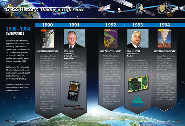
GPS World’s 25th Anniversary GNSS History Timeline, from the September 2014 Special Supplement “GNSS Industry: Past, Present, and Future.” Download the PDF.
Actions Necessary to Reduce Vulnerability and Ensure Availability
By Brad Parkinson
(From the 25th Anniversary GNSS History Special Supplement)
Introduction
Brad Parkinson
About 40 years ago, we had a vision for positioning, navigation, and timing (PNT). That vision was more than successful, and became known as GPS. In some respects we have been almost too successful: PNT is frequently taken for granted. PNT, in the form of GPS, has become a powerful worldwide enabler for productivity and for safety. Estimated yearly value runs to many tens of billions of dollars.
For several years, I have been concerned about comments that denigrate GPS because the signal strength is relatively weak. The speakers have gone on to say it can be completely replaced with inertial or other techniques. Recently, comments by government officials further energized me to look at the full picture.
What can we do to reduce the vulnerability and ensure that the expectations of the users are going to be met? I summarize my solution as the PTA program and will elaborate in this article. At a top level, the term PTA means: Protect, Toughen, and Augment GPS to assure PNT. Note I say PNT, not GPS. The central issue is assuring access of PNT to the user, not the source of the information. I strongly believe that PTA is both achievable and absolutely necessary. Protecting PNT is particularly important to Europeans as they are just about to launch their fledgling Galileo system.
Speeches and travel only reach a limited number. When GPS World invited me to write a piece for the magazine’s 25th anniversary issue, it seemed an ideal opportunity to expand knowledge of the PTA program. The following is an edited form of a talk I have given a number of times, most recently at the European Navigation Conference in Rotterdam in April 2014.
GNSS initiatives and the GNSS community are growing rapidly, and certainly we are very enthusiastic about the progress of Galileo. But some places in the U.S. community are saying, “Well, this GPS band is underutilized; devoting all that bandwidth to a single system is not prudent.”
I beg to differ with that view. If you look at the separate signals in the L1 band around the world, by the year 2023 they will grow to be well more than 400 individual signals. Those signals service over 2 billion users, from emergency service providers to precision agriculture to crustal monitoring and many, many more. I have an entirely separate talk on “GPS for Humanity,” but that is not our subject today.
Calling the GPS frequency band “underutilized” simply points out ignorance, even among our supporters. For example, we say PNT to emphasize that GNSS provides four dimensions. Certainly, timing is the forgotten fourth dimension of GPS, and even our politician friends rarely understand the importance of this aspect. Yet we know that highly accurate timing, supplied by GPS, is absolutely critical for power distribution, for telecommunications, and for the financial sector.
It is instructive to summarize the penetration of the PNT “Stealth Utility” into the fabric of our society.
Market Size. Overall, GPS has more than 2 billion users worldwide. This represents a very diverse user group; we providers are continually seeing new and innovative ways to use GPS.
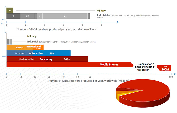
Figure 1, for which I am indebted to Frank van Diggelen, gives an estimate of the number of receivers currently fielded. Notice the number of military receivers: less than half a million. The gray bar depicts the industrial uses such as survey and machine control, which come in at about 4.5 million; these tend to be extremely high enhancers of industrial productivity.
Figure 1. GNSS market size, 2012.
We have to change the chart scale to depict bigger market segments. For example, recreation, automotive, and computing are shown on the lower half of the chart. In fact, mobile phones will still not fit on the chart. Attesting to the size of the estimated mobile phone base: one company alone will produce more than 900 million GPS-equipped smartphones this year. The pie diagram shows the dominance of mobile devices, but much higher productivity gains come from high-precision devices whose impact is very disproportionate to numbers of receivers.
We asked some economists, just what is all this worth? They looked at a subset of all the industries and concluded that GPS has a positive net effect to the tune of at least $32 billion annually. They had an expanded study that suggested about $90 billion annually. So, for those who question the value of GPS, the answer is that the net yearly returns to our national investment are more than 1000 percent. (Note: National investment is about $3 billion annually.)
To ensure these enormous economic benefits of PNT, there are two fundamental needs, and we providers must assure that they are met. The first and most important need is availability.
Availability. When we say availability, it is defined in a certain way; it means that PNT is available at the application-specified accuracy. We usually measure that accuracy at the 90th percentile: only 10 percent of the time can that error be exceeded.
Integrity. The second user need is the required integrity. That means that when the user expects a specific accuracy, the system is not lying to him. Integrity assurance is very much a focus of both the International Civil Aviation Organization (ICAO) and, in the United States, the Federal Aviation Administration (FAA). In many cases they require that PNT errors not exceed specified bounds more than once in 10 billion measurements (1 x 10⁻⁷). This integrity level requires so many samples, it is virtually impossible to verify experimentally; we have not had that many airplane landings, but it can be calculated. The metric we use is how many minutes GPS is not available — unavailability — at the specified accuracy and integrity. That is more easily understood than availability that aproaches 99.9XXX percent. The usual goal is that unavailability be zero.
We have an independent assessment of how well we are doing: FAA’s Wide Area Augmentation System (WAAS). They put out a report card with a lot of numbers. GPS clearly deserves a grade of A+.
And it will get better. The U.S. government’s PNT Advisory Board, which I co-chair, recently advocated that the full navigation message be added at the new civil frequencies, the L2C and L5C signals. The Air Force has now complied, thanks to strong support from General Willie Shelton. This makes two more civil signals fully available. They currently expect 2.9 meter ranging accuracy, but by the end of the year the Air Force operators expect the same full accuracy as the rest of the signals, on the order of 0.5 meter of ranging error.
This is an outstanding picture.
So What’s the Problem? A statement made by a high-level U.S. government official in my presence exemplifies the problem: “GPS is much too vulnerable. We must replace it with new inertials and chip-scale atomic clocks.”
I found this statement appalling. Unfortunately, it was a meeting where you don’t normally speak up, and I didn’t. Nonetheless, to me, that was totally wrong.
GPS indeed has a very weak signal, and it depends on having clear line-of-sight to four satellites. But in my opinion, a much better statement is what I call the PTA solution. Our goal should be to:
Protect the system and the signal.
Toughen the receiver and the system.
Augment GPS as needed to ensure users’ PNT requirements are met.
The focus is ensuring positioning, navigation, and timing (PNT), not merely ensuring GPS.
Fundamental Prerequisites for PNT
The first prerequisite for GPS-based PNT is a receivable, clear, and truthful(truthful implies full integrity) ranging signal. There are five main challenges to this.
Too-powerful authorized signalsnearby. This aspect snuck up on our community. The FCC authorizers were about to license a powerful signal in the frequency band adjacent to GPS, drowning out any hope of receiving the GPS signal. This can be called the authorized jammer. All PNT providers must be very vigilant about this; we have seen ignorant elements of the government poised to do great harm with well-intended but destructive actions, without knowledge of the unintended consequences.
Natural Interference. This interference, the cause of delays and attenuation, is reasonably well understood, and the subject of much research, dating back to when we first defined GPS. Random events such as solar flares can potentially cause great harm.
Inadvertent Natural or Manmade Jamming. A nearby device that creates spurious, destructive emissions can be a serious problem for GPS receivers. This class tends to be manageable by well-designed receivers.
Collateral Interference. An example is a person who wants to evade tracking but is inadvertently jamming nearby GNSS receivers in addition to his own local receiver.
Deliberate Jamming or Spoofing. This is perhaps the major concern for developers and users. I will discuss this further later.
There is a second major prerequisite: satellite geometry. The user who cannot see enough of the sky is called “sky-impaired.” There are two possible underlying problems:
The satellite constellation has “brown-out” because of failures or inadequate numbers; or
The user is operating in a mountainous or urban area with high, local shading angles.
Overcoming sky-impairment requires a denser constellation, or use of multiple GNSS.
Protect, Toughen, Augment
What can we — as developers, operators, and manufacturers — do to overcome the PNT availability challenges for our users? My solution is PTA. The good news is that quite a few of the actions I recommend are underway — in fact, many of GPS World’s readers are active participants.
I am going to examine these three PTA principles, expand on them a bit, and hopefully explain a few things that help focus on a broad solution.
Protect the System and the Signal
This can be organized into seven actions: three PreActions and four ReActions. PreActions are before there is serious interference, and ReActions obviously come after interference is occurring.
First, the PreActions.
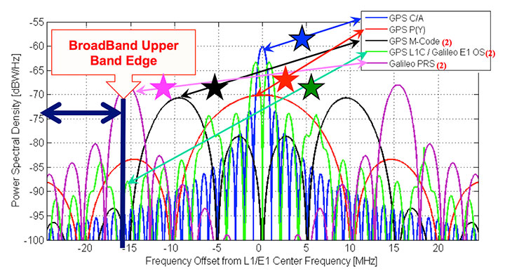
Protect the Spectrum. The chart in Figure 2 represents the frequency plan for the L1 band, and displays some of the sources of the 400 signals I referenced earlier. The blue star, GPS L1 C/ A, is the only fully operational and reliable signal in the world right now. The red star is the U.S. GPS military signal. You can see it has important power lobes close to the band edge. The black star is M-code, the new military signal of the United States.
Figure 2. Frequency plan for the L1 band.
The Galileo power curve, which is pale green, has very significant nodes close to the band edge. Of course, the Galileo PRS (the magenta star) is right on the band edge. The imperative for these wider bandwidths is that they produce sharper correlation edges and consequently produce greater measurement precision. This leads to greater accuracy, and greater usefulness and utility for many PNT users.
Reallocation of radio bands adjacent to GNSS poses a significant threat. The band edge of the proposed high-power communication signal (sometimes called broadband) appears as the black vertical line. It is obviously very close to the edges of many of the colored PNT signals. Tests conclusively demonstrated unacceptable levels of interference with L1 C/A.
Consider the proposed, high-powered terrestrial signal one quarter-mile from a GPS receiver. This produces a power ratio of 5 billion (broadband) to one (GPS). To visualize that power ratio, consider Niagara Falls, which produces about a billion watts. Compared to that, GPS power is a tablespoon of water dropped from five feet, once per second (about 0.2 watts). This is the power ratio that was almost authorized with 40,000 ground-based transmitters in the U.S. At a city block away, the effect is 10 times worse.
To quantify interference effects, some initial tests were run and measured broadband effects used for analysis. Cell-tower locations near Las Vegas, Nevada, approximated the broadband transmitter locations. The nearby airport, McCarran Field, has three RNAV (GPS) approaches. As expected, GPS users on the ground would be significantly jammed, but the effect on aircraft would be nine times worse than the impact on ground receivers. This is due to altitude (line of sight), geometry, and the sensitivity of aircraft receivers.
The 12 broadband transmitters around McCarran Field would jam all of the RNAV GPS approaches to all three runways. Signals of this type would effectively shut down or severely limit operations at the airport.
Signals in the GPS band will increase in the next decade as the newer GNSS become operational. The proposed, adjacent broadband is even more incompatible with these newer signals since they will be closer in frequency. Note that the whole approach was rejected, solely on the basis of L1/CA. It was not even tested against the other, more susceptible, modern signals. The worst would have been yet to come, had they been authorized to broadcast in the adjacent band.
Adjacent bands can continue to broadcast non-GNSS signals originating in space because the power levels will be comparable with the PNT spectrum. But we must be very vigilant to stop any high-power terrestrial signals from being allowed. They would become, effectively, authorized jammers. There should be no spectrum reallocation to ground transmitters until technology has been thoroughly demonstrated to solve any problems, (particularly for the high-precision users) and there is enough time to re-equip the users.
Europeans should have two other important frequency authorization concerns. First, there is a legal barrier within the United States to using Galileo signals. They have not been formally authorized. I think it is a bureaucratic glitch, but it is something we in the United States have to solve; we do want to use all GNSS signals. Stay tuned!
There is another concern. A group at the Electronic Communications Committee, European Commission, recommends allowing pseudolites in the L1 GNSS band. As an experienced user of pseudolites for aircraft landing and some other applications, I believe this is a very risky idea; pseudolites can be very useful, but frequencies should be found elsewhere to avoid unexpected interference.
Stiff Legal Penalties for Interference. The second PreAction is to enact stiff legal penalties for GPS jamming, both in terms of jail time and fines. The goal is to deter the ubiquitous $33 GPS jammer that one can buy on the Internet.
On the U.S. FCC website, the agency lists the penalties for having a GPS jammer. Forfeitures range up to $16,000, and they might even put you in jail. The Australians take a much stronger view: up to five years imprisonment or $850,000 in some cases. Some people are alarmed by these heavy penalties and call them brutal. However, they are not always imposed, and if jamming and spoofing is intentional, especially where the landing of airplanes is concerned and lives are at stake, I think a strong deterrent is warranted.
Stop Jammer Manufacturing, Sales. The third pre-action is to prevent proliferation by shutting down manufacturing and web sales of jammers. What is the status?
The FCC website states that manufacturers should comply with the law: stop marketing these devices in the United States and stop selling and shipping to addresses in the United States. The loophole is you apparently can manufacture these devices if you sell them outside the U.S. Now, I have a little difficulty with this. I have pointed this out to the DHS and others; hopefully, stronger action will be taken.
The FCC told me in an open meeting a few months ago that they were shutting down the websites where these devices are sold. But about three weeks ago, I went online and immediately found a website that sells nine different devices to jam GPS and cellphone devices. Indeed, there were jammers, all very affordable, for jamming just about everything. More recently, the FCC assessed a multi-million dollar penalty against such a jammer manufacturer. We will see if this actually happens. I hope they accelerate these efforts.
Now for the ReActions.
Detect Jamming. To stop jamming, the first step is to know when it is occurring. There are a variety of ways to do this. Some devices or concepts are already on the table: for example, a Chronos CTL3510 GPS Jammer Detector, an Exelis Signal Sentry Jammer Detector, and the J911 cell phone detection and reporting of jamming, an example from NavSys.
The idea behind the NavSys J911 is that all GPS-equipped smartphones have the capability to detect jamming. This does not pinpoint jammer location, but alerts authorities to the problem. Phone location can be reported to a central database for the next two actions.
Pinpoint Jammer Location. Techniques range from directional antennas to time-difference-of-arrival using Fast Fourier Transforms. The latter was demonstrated for the FAA at Stanford more than 10 years ago: location pinpointed within five meters. Cell towers could implement such techniques, since they have accurate time and could run correlations. There are already commercial GPS jamming locators: something called a JLOC (NaySys Jammer Locator). The British are using similar techniques for jammer detection on some of their freeways.
Eliminate Jammer. Having pinpointed the jammer, the next step is to physically eliminate it. What is the status? At Newark Airport there is an FAA, ground-based GPS augmentation system antenna right next to the turnpike. They are part of a blind landing system. In early 2010, there was an infamous jammer interfering with the FAA GPS receiver. It took three months to locate the offending truck driver and shut down the jammer. The good news is that, more recently, in the same general location, they located a similar moving jammer within 24 hours after the interference started. However, these are very special locations. Recent studies have suggested that interference sources are much more widespread. Note: Only certain enforcement personnel are authorized to seize the jammer and arrest its operator.
Prosecute. Having located the offender, the law should then be applied to prosecute. Leeway should be applied, commensurate with the circumstances. In this New Jersey case, the authorities say the perpetrator is liable for a forfeiture of $31,875.
Toughen Receivers
There are at least five well-known ways to toughen receivers, thereby increasing jam resistance:
Increased satellite signal spreading (such as L1C, L5) allowing greater processing gain;
Integration with inertial navigation components;
Digital beam-steering or null-steering antennas;
Increased satellite power such as L5 (a difficult and fairly expensive technique);
Local antenna shading, for example, the top of an airplane, which is shaded from the jammer.
These improvements cascade and are cumulative, but a remaining issue is to make such techniques more affordable.
To illustrate these anti-jamming techniques, consider the effective area of a 1-kW jammer located on the Capitol building in Washington, D.C. A basic high-quality GPS receiver, within a line-of-sight range of 20 miles, will stop providing PNT. Simply using the newest L1C spread-spectrum GPS signal reduces the jamming area by about two thirds, allowing operation to about 10 miles from the Capitol. Adding inertial aiding allows PNT to within three miles, and adding digital beam-forming antennas and using aircraft natural shading brings the effective radius to about 0.1 mile, about the size of the capital building.
The point is toughening the PNT receiver with the technologies mentioned is an extremely effective strategy. It would require over 60,000 jammers to cover the same area as the original non-toughened GNSS receiver.
Some techniques are very affordable today, while others, such as digital beam-forming antennas, remain too expensive for the ordinary user. In addition, there is a potential U.S. problem of export restrictions. Unfortunately, many of these existing restrictions have simply incentivized non-U.S. development of equivalent capabilities.
Augment
The last element of the PTA construct is to augment or substitute PNT sources. We are all aware of the coming revolution in multiple PNT sources from new GNSS. An all-GNSS receiver diversifies the frequencies and the signals, thereby reducing vulnerability to interference. It also improves availability for the sky-impaired user because of densification of satellites sources. Using satellites from multiple constellations can significantly improve availability, provided integrity requirements are met.
With these additional GNSS constellations, there are three major levels of cooperation:
Compatible: no mutal interference;
Interoperable: working to allow common time and geodesy system;
Interchangeable: using accurately calibrated biases and offset. Any four SVs will suffice.
The major issue again is probably integrity, because to ensure economic value, availability requires known integrity. As far as the U.S. FAA and ICAO are concerned, for precision aircraft operations the integrity value should be that the system be “out of spec” less than once in 1 billion times. To be productive they also would like zero minutes of unavailability. That may seem extreme, but commercial aviation and public safety demand it. Regarding integrity, some new GNSS are clearly making faster progress than others.
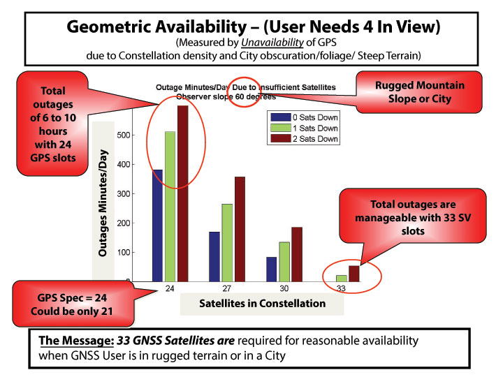
It is useful to further examine the densifying opportunity of additional GNSS. The chart in Figure 3shows how densification can impact the user. The number of satellites (SVs) available in the sky (assumed optimal distribution) is shown. The colors refer to whether 0, 1, or 2 SVs are out of commission for maintenance or repositioning (typical maximum is 1 for GPS). The measure of effectiveness is minutes of outage per day. Consider a shading angle of 60 degrees, representing a user near a rugged mountain slope area or a city. With the nominal 24 SV GPS constellation (the GPS specification is 24 despite the U.S. having 31 active SVs), the outages, due to geometry alone, are six to ten hours. Improvement with additional satellites is dramatic and quite non-linear. With 33 satellites (about a 37% increase in density) outages are zero minutes per day to 33 minutes if one satellite is out for maintenance (reduction by a factor of over 10!). Of course, SVs could be from different GNSS constellations if they are truly interchangeable and have the required integrity. The clear message is that about 33 SVs are needed to cover reasonably high elevation angles.
Figure 3. How densification of additional GNSS can affect the user.
Integrity Monitoring. Currently, the U.S. GPS control segment continuously monitors GPS satellites. If a fault is found, they set the satellite inoperative until the problem is resolved, which may take many minutes. This alarm time is not fast enough for precision aircraft landing and approach (the requirement is six seconds to alarm). For these rapid integrity alarms, the United States relies on the FAA’s WAAS, and Europe uses EGNOS to monitor the basic GPS L1 C/A signal. Soon, the EGNOS message will include Galileo integrity alerts. Unfortunately, the United States does not yet have a plan for reciprocal WAAS monitoring of Galileo signals. In fact, formal approval to even use these signals has not yet been granted by the U.S. FCC.
Self Integrity (RAIM). If an all-GNSS receiver has more than six satellites in view, the user can use the Receiver Autonomous Integrity Monitoring (RAIM) technique. This allows the user to cross-check each measurement against others to find erroneous satellites and guard against spoofing. Take the recent GLONASS situation. With a good RAIM PNT receiver, the user could quickly isolate the large errors from the combined set of GPS/GLONASS measurements. In fact, some deployed receivers did just that. If all GNSS are totally interchangeable, it will be enormously helpful to implement RAIM.
The recent, prolonged GLONASS outage saddened us all because it reduced the credibility of all GNSSs. We hope the Russians will be forthcoming in announcing what happened and the corrections that are being made; hopefully, it won’t happen again.
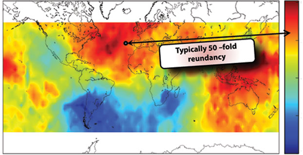
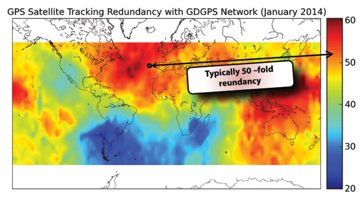
Fortunately, there is a third independent, real-time tracking network of 200+ sites, known as the Global Differential System (GDGPS). Although NASA administers GDGPS, local-country scientists maintain and operate individual sites in near real time. GPS is monitored down to centimeter precision.
A central issue for GDGPS is whether the integrity monitor capability itself has integrity. Because of redundancy and independence, a form of inverse RAIM, hereby named System Autonomous Integrity Monitoring (SAIM), can be used. Figure 4 depicts the number of independent looks or ranging measurements to a single satellite over various points on the Earth. You can see in the dark areas the value is 60, and even in the relatively unmonitored areas around South America, the redundancy is 20. At a typical spot, perhaps off Spain, it depicts 50-fold redundancy. By cross-checking the dozens of GDGPS measurements for each satellite, a strong integrity cross-check can be created. The GDGPS plan is to also monitor Galileo as it becomes operational. Thus, GDGPS has excellent prospects to provide real-time integrity assessments for all users and all operational constellations. We need plans to connect all users to these potential integrity alarms.
Figure 4. The number of independent looks or ranging measurements to a single satellite over various points on the Earth.
There are three classes of ground-based augmentations:
Pseudolites. Ground augmentations could also include pseudolites broadcasting GPS-like signals for additional ranging. While somewhat helpful, this technique cannot cover large areas and can act as a strong interference source if the signal is in any GNSS frequency band. For this reason, in my opinion, pseudolites should never be authorized in GNSS frequencies.
Distance-Measuring Equipment. Modernized DME, planned as a GPS supplement by the U.S. FAA, is very valuable for the airborne users. Most ground users derive no benefit from DME because they do not have line of sight to the widely scattered transmitters. Ohio University’s Frank van Gras is working for the FAA on a DME plan should GPS not be available. It involves moving from the so-called legacy DME to the enhanced DME to ensure continuous aviation operations.
eLoran. eLoran, covering expandable local regions, uses a powerful signal at an entirely different frequency. It is two-dimensional, but in calibrated areas differential (eDLoran) is perhaps as accurate as 10 meters for harbor areas and similar purposes.
I chaired a study of eLoran for the FAA in 2006. Initially skeptical, the study members finally concluded (unanimously) that eLoran:
meets the needs of all identified critical applications: 10–20 meter navigation accuracy for harbor entrance; 0.3 mile required navigation performance (RNP 0.3); stratum 1 frequency precision and 50-ns time accuracy.
is a modern system: new infrastructure, solid state transmitters, state-of-the-art time and frequency equipment, uninterruptible power supplies; new operating concepts, time of transmission, all-in-view signals, message channel with differential corrections, integrity; new digital user equipment, processes eLoran and GPS signals interchangeably, compact H-field antennas eliminate p-static.
is affordable: Less than $143M to fully complete eLoran, avoid costs of decommissioning existing Loran-C infrastructure; operations and maintenance currently $37M/year, reduced with eLoran-enabled automation.
And our group concluded it was the most prudent and cost-effective general augmentation or backup to GPS.
The National PNT Advisory Board also unanimously recommended that we deploy eLoran. The departments of Transportation and Homeland Security supported it; then, after a change of administrations, in a budget crunch, it was defunded, and the dismantling of existing Loran C stations began. Congress now may be taking action, and the recent GLONASS outages should give an impetus to that.
Who Will Implement PTA?
To my knowledge, many elements are currently being pursued, some by GPS World readers. But I can identify no entity that has the authority, the knowledge, the breadth, and the resources to create a single, well-focused program. This reminds me of a fable from Aesop regarding ants. When no leadership emerges, the ants have to band together to solve the problem. Yes, I am suggesting that we are the ants and we all must contribute to the solution, as well as seeking governmental agencies to step up to the responsibility.
In that regard I have a “to do” list. We must:
Protect PNT.
Vigorously defend the spectrum.
Work with lawmakers to increase legal penalties for PNT interference.
Work with manufacturers and law enforcement to improve timeliness and accuracy of interference identification (crowd-sourcing, every cell phone a detector).
Field jammer location equipment.
Toughen PNT.
Develop industry (ICAO/RTCA/RTCM) standards for deep inertial integration and directional antennas.
Develop vector receivers (all GNSS).
Continue to implement ARAIM and inertial for integrity (+WAAS/EGNOS).
Encourage users to move to rugged receivers.
Augment PNT.
Expand integrity notifications to include GDGPS.
Develop RTCA standards for seamless DME and GPS/GNSS.
Implement eLoran and develop RTCM standards for seamless use.
Develop an international process for integrity certification of all GNSS (GLONASS, Galileo, and BeiDou).
In conclusion, the rumors of the death of GPS, in my opinion, are greatly exaggerated. Let’s not throw out the baby with the bath water. Instead let’s accelerate and expand PTA to Protect our band, and Toughen our receivers, and Augment GPS to ensure that PNT is available for all users now and in the future.
In the words of American poet Robert Frost,
The woods are lovely, dark and deep,
But we have promises to keep,
And miles to go before we sleep,
And miles to go before we sleep.
Thank you.
BRAD PARKINSON has been the Edward C. Wells Endowed Chair (emeritus) at Stanford University, where he is a recalled professor of aeronautics and astronautics.
He co-founded the well-known Stanford GPS Laboratory and led the development of many innovative uses of GPS, including blind aircraft landing, precision farm tractors, and the prototype of the FAA’s WAAS. He also directed development and was a co-PI for the successful test of Einstein known as Gravity Probe-B sponsored by NASA. He worked in various executive or board capacities at Trimble Navigation, Intermetrics, Rockwell International, and The Aerospace Corporation.
As an Air Force colonel, from 1972 to 1978, he was the chief architect and first director of the NAVSTAR GPS development program, retiring from the service after orbiting the first GPS satellites and proving GPS capabilities. He is a fellow of five professional societies and recipient of dozens of awards, including:sharing the 2003 Draper Prize with Ivan A. Getting for leading the development of the Global Positioning System.
Flying for GPS, a chronicle of Len Jacobson’s role in the development and promotion of the Global Positioning System, has just been published.
The book spans a 50-year career, during which Jacobson flew 2.5 million miles as a missionary for GPS and as a developer of user equipment. He kept an extensive log of all of his flights, and it enabled him to recreate in his book much of what happened with GPS during his career, and his impressions of why these events occurred.
Flying for GPS covers the user-equipment evolution from expensive, complex, and voluminous military sets to today’s low-cost chips buried in our cell phones. It traces a system designed primarily for military and civilian aircraft, ships, and land vehicles to an essential utility of everyday life, enabling new businesses, more safety, and the ability to track everything that moves. It is also a memoir written for the GPS community.
The book draws from Jacobson’s GPS experience while working for Hughes Aircraft, Magnavox, Interstate Electronics (IEC), and his own company, Global Systems and Marketing, Inc.
He worked on various assignments from most of the major GPS companies and several small businesses that were trying to find a position in the GPS market. He also participated as an expert witness in many legal cases involving GPS, from patent disputes to accident reconstruction to parolee tracking.
In parallel with the evolution of GPS, the book chronicles the changes in commercial air travel as Jacobson experienced it, from flying on a PanAm 707 in 1963 to an Air France A380 today. The book is available now from www.xlibris.com, Amazon, Barnes & Noble, and soon from ebook outlets.
Len Jacobson.
Excerpt from Flying with GPS
By Len Jacobson
A man in a trench coat borrowed one of our civil GPS Z-sets in late 1979. He couldn’t or wouldn’t say what it would be used for. He suggested that I call over to the Joint Program Office (JPO), and they would verify the validity of the request. A year later I found out what it was all about.
The Z-set had two boxes, a receiver and a panel mounted control/display unit (CDU). We got the receiver back but we never got the CDU. I learned later that the Z-set had been installed in one of the helicopters used in operation Eagle Claw, the failed April 1980 raid to rescue the U.S. Embassy hostages in Iran. I guess the Special Forces were able to recover the Z-set receiver but not the CDU, as the helicopters were all destroyed.
I ran a coverage plot for the day of the raid over Iran, and found four satellites were in view at that time. I also received a copy of an Iranian newspaper that had a big article on GPS in Farsi. I couldn’t read it and I don’t think it mentioned the raid, but there was a diagram of the GPS constellation, so I know the Iranians were very aware of GPS. That mission may have been the very first operational military use of GPS.
Another Covert Role. In September of that same year, a Vela reconnaissance satellite detected a “double flash” that was deemed by many to be evidence of a atmospheric nuclear explosion off of South Africa in the South India Ocean. While many of the details are classified, there is quite a write up about it in Wikipedia, under “Vela Incident.”
This came at a time when the GPS program was in even greater budget peril than normal. The Secretary of the Air Force at that time was trying to zero out the GPS budget, and it looked very likely he would succeed. But along came a procurement for a Nuclear Detonation Detection System payload package to be placed on all future GPS satellites. I believe that saved the GPS program from a premature demise.
I also suspect, as do many others, but cannot prove, that the flash was created by an Israeli nuclear test. If so, one might infer that Israel actually, albeit unwittingly, saved the GPS program from extinction.
Len Jacobson is a retired GPS consultant, having worked in the field since 1968. He is a charter member of the Editorial Advisory Board of GPS World magazine and is also still active in the Institute of Navigation, for which he served as western regional vice president twice and held leadership roles in several of its conferences. He lives in Long Beach, California. Visit his site at www.lenjacobson.com.
Flying for GPS, a chronicle of Len Jacobson’s role in the development and promotion of the Global Positioning System, has just been published.
The book spans a 50-year career, during which Jacobson flew 2½ million miles as a missionary for GPS and as a developer of user equipment. He kept an extensive log of all of his flights, and it enabled him to recreate in his book much of what happened with GPS during his career, and his impressions of why these events occurred.
Flying for GPS covers the user-equipment evolution from expensive, complex and voluminous military sets to today’s low-cost chips buried in our cell phones. It traces a system designed primarily for military and civilian aircraft, ships, and land vehicles to an essential utility of everyday life, enabling new businesses, more safety, and the ability to track everything that moves. It is also a memoir written for the GPS community.
Flying for GPS draws from Jacobson’s GPS experience while working for Hughes Aircraft, Magnavox, Interstate Electronics (IEC), and his own company, Global Systems and Marketing, Inc.
Len Jacobson.
He worked on various assignments from most of the major GPS companies and several small businesses that were trying to find a position in the GPS market. He also participated as an expert witness in many legal cases involving GPS, from patent disputes to accident reconstruction to parolee tracking.
In parallel with the evolution of GPS, the book chronicles the changes in commercial air travel as Jacobson experienced it, from flying on a PanAm 707 in 1963 to an Air France A380 today. The book is available now from www.xlibris.com, Amazon, Barnes & Noble, and soon from ebook outlets.
Len Jacobson is a retired GPS consultant, having worked in the field since 1968. He is still active in the Institute of Navigation, for which he served as western regional vice president twice and held leadership roles in several of its conferences. He lives in Long Beach, California. Visit his site at www.lenjacobson.com.
Our esteemed editor-in-chief and publisher at GPS World, Alan Cameron, penned an editorial in January concerning claims made by the People’s Republic of China regarding the Gold Standard for PNT (position, navigation and timing). The Chinese recently claimed that its BeiDou system averaged a user range error (URE) of 2.5 meters using zero age of data (ZAOD), 95% of the time.
Alan correctly made the point that today BeiDou is strictly a regional system, and that while the published and arcane (30-year-old) standard for GPS is 6 meters under the same conditions, this is merely a standard, a never-to-exceed boundary, and not an actual URE measurement. GPS has always provided significantly better than 6 meters accuracy, with a reasonable age of data, while the GPS numbers for URE have significantly improved on a consistent basis since 1978 and today are the best in the world for any global PNT system.
Dr. Bradford Parkinson, the father of GPS, after reviewing the Chinese data pointed out that, “ If a GNNS has full view and an immediate update (such as Compass [BeiDou]) they can drive the AOD down, effectively becoming a WAAS system. This result would not represent a global capability. Plus, there are other errors for a single-frequency receiver in addition to the ionosphere (that is calibrated by WAAS and EGNOS), including troposphere modeling errors, and multipath that drive the ranging error up for a civil user depending on the situation.”
This data is very useful for GDOP (Geometric Dilution of Precision) statistics, which are quite surprising – and come about because of the 30+ GPS satellites in view and the resulting excellent geometry available.
The public data clearly shows that the GPS system is every bit as accurate, and indeed comparatively nominally much more accurate, than BeiDou, and GPS covers the entire globe, not just an area over China and portions of Australia.
It All Starts Here — GPS SIS URE
The GPS accuracy equation begins with the signal in space (SIS). Since 1978, the SIS figures for GPS satellites have continuously improved, as I said primarily due to more accurate orbit determination and more stable atomic reference systems, while the GPS URE numbers have continued to decline. Which is a good thing – smaller URE numbers are better.
Indeed, this clearly explains, in my opinion, why SVN49, which is a perfectly healthy GPS satellite, has never been set to healthy status. While the SVN49 GPS signals are all well within the published 6 meter URE – a never exceed threshold – they are significantly greater than 2 meters. Accuracy matters with GPS, so until corrections can be made, the satellite will remain in test status. Today, it serves as a very useful orbiting GPS test bed but does not enter into the SIS or URE equation.
GPS SIS URE is best explained as the pseudo-range inaccuracy due to ephemeris (orbit) and clock (atomic reference system) errors, which are common to all modern space PNT systems. The SIS root-mean-square (RMS) URE for GPS has been steadily declining over time (smaller numbers are better) and, consequently, so have the user range errors for users on the Earth. However, for my technical readers and space physics buffs, SIS errors are not determined by simple equations and therefore are sometimes difficult to describe accurately because they are neither purely stochastic nor deterministic. Indeed, Ph.D.-level subject matter experts such as Liang Heng, Grace Xingxin Gao, Todd Walter, Sherman Lo and Per Enge, from Stanford University, have clearly shown that SIS errors do not necessarily have a normal distribution Also, the traditional statistics such as sample mean and sample standard deviation may be affected by extreme excursions or outliers. However, these deviations do not significantly affect URE for most users, as they are effectively smoothed by long-term trend analyses and an active Kalman filter.
Better Clocks
Certainly, better atomic reference systems with frequency stabilities on the order of 1×10-E13 or better are partially responsible for these improvements, since one nanometer of clock stability typically equals one foot of position accuracy on the Earth’s surface. That number is important because I clearly remember the day in 1990 at the 1CACS (1st Command and Control Squadron) in Cheyenne Mountain (the 1 CACS is now located at Vandenberg AFB in California), when it was explained that the nominal ephemeris tracking error via optical systems for GPS satellites was on the order of two kilometers. The 1 CACS was responsible for providing collision-avoidance support during NASA shuttle missions and is still responsible for maintaining an extensive space satellite and space object catalog. Today, that error, using different tracking methods — including a global network of dual-frequency GPS tracking and monitoring sites — for GPS SVs approaches two centimeters or better. Consequently, better (more stable) clocks and more precise orbit determinations have greatly reduced the signal-in-space errors and significantly improved the position accuracy for all GPS users on a global scale. And for me that is the crux of the issue for GPS versus any other space-borne PNT system in existence today, or for any system in the near future.
A Global System
GPS is and has always been a global system, since its inception (1973) 41 years ago this year and since President Reagan decreed on September 16, 1983, just 15 days after Korean Air Flight 007 was tragically shot down by fighter aircraft from the Soviet Union (there were four other similar tragedies involving the Soviet Union on record) for being off course, that the Global Positioning System would be a gift from the United States to the world for precise navigation, so that this type of disaster need never happen again. Since that time GPS has been a truly global system for all users, friend or foe, without distinction. Of course longevity and dependability are merely two of the important factors that makes GPS the PNT Gold Standard.
GPS Stands Alone
I do not intend nor do I need to defend GPS as the global Gold Standard for PNT, the figures speak for themselves, however I do feel that the words Gold Standard, as I and many other subject matter experts, interpret them, may need a bit of an explanation.
One of my professional colleagues and a dear friend, for more years than I care to count, and I have long disagreed on this terminology. He feels the term Gold Standard is easily misinterpreted and should not be applied to GPS simply because it is not always well understood; instead he prefers the term system of first choice. However, that just does not have the same ring or historical significance as the Gold Standard.
What is a Gold Standard?
Leaving aside the monetary or financial implications for our PNT purposes, a Gold Standard is defined as the best one or the very best example of its kind — with synonyms such as: a system benchmark, a yardstick, a touchstone, the criterion, a paradigm and the epitome. Add to these descriptors the sense of longevity, endurance, dependability, and quality the GPS engenders among users — and you may be approaching the true sense of the phrase “Global PNT Gold Standard.” I can say unequivocally that the GPS is the only space-based PNT system in existence today that meets all these exacting and more fluid definitions simultaneously.
Historical Perspective
The Global Positioning System has had a continuous on-orbit presence since the second NRL Test and Development satellite was launched in 1977. GPS achieved IOC or Initial Operating Capability with 24 SVs (satellite vehicles) on December 8, 1993 (2SOPS celebrated the 20th anniversary of GPS IOC in December 2013). GPS FOC or Full Operational Capability was achieved on April 27, 1995, just 16 months later. Since that date, the GPS has never been less than fully operational, providing both the military Precise Positioning Service (PPS) and the civil Standard Positioning Service (SPS) to global users. As the staff writers at GPS Daily stated in a recent anniversary article:
Amazingly, though many Navstar satellites have been launched and been decommissioned over the past 20 years, four of the original Block IIA satellites which made up the IOC constellation (SVN-23,SVN-26, SVN-34, and SVN-39) are still operating and providing reliable PNT services as of this 20th Anniversary of IOC.
GPS has grown to become a vital worldwide utility serving billions of users around the globe. GPS multi-use PNT services are integral to the United States global security, economy, and transportation safety, and are a critical part of our national infrastructure. GPS contributes vital capabilities to our nation’s military operations, emergency response, agriculture, aviation, maritime, roads and highways, surveying and mapping, and telecommunications industries, as well as recreational activities.
It is not an overstatement to say GPS is fundamental to today’s technical infrastructure and culture. GPS provides the ‘winning edge’ to our warfighters and allies by delivering premier space-based PNT services to the nation and the world.
This indeed supports the definition, as I see it, of a Gold Standard for global PNT. A system that is long-lived, dependable, and just keeps improving every day. A ubiquitous utility that has changed the world we live in and the way we live our lives for the better, a system that now defines not only the critical national infrastructure of the United States but of many nations around the globe.
As for GLONASS, Galileo and BeiDou, we can have this discussion again in 20 years or so when they have been IOC and FOC for a credible period of time and have proven their accuracy, longevity and utility. For now, there is only one Gold Standard and that is the Global Positioning System.
What Is Don Reading?
This month, my reading preferences centered around mythical and real life figures in the CIA or Central Intelligence Agency. And frankly, sometimes it was hard to tell the difference.
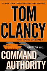
screenshot: “Command Authority”
Command Authority, by Tom Clancy with Mark Greaney Putnam and Sons, ISBN: 978-0-399-16047-9
I devoured this 740-page tome in one weekend and was looking for more when I finally finished. This is one of those books you don’t want to end. It describes the life of the young Jack Ryan as a CIA operative during the Cold War, and of his son, Jack Jr., today. The authors manage the timeline to and fro adroitly so that it is never an issue. As usual, the action spans the globe and as far as I can determine the historical facts are accurate and the scenarios are riveting but believable.
Tom Clancy passed way just about two months before this final book was published. He managed to write 28 books in 30 years, a prodigious feat considering most of them were on the order of 700 pages or more (Threat Vector runs 840 pages). But to my mind, they were all too short, and Tom managed to exit, as any writer would desire, leaving his avid readers yearning for more.
Until next time, happy navigating, and think about what a difference GPS, the PNT Gold Standard, has made in your life. You might be surprised. And then grab a good Tom Clancy book. You have 28 excellent volumes from which to choose.
Remembering a Time before GPS — and a Lifelong Friend
One of my oldest and best friends died today – and he was just a kid, only 62. In the prime of his life, and yet I know he led a very full life and had no regrets when he passed on to that highway in the sky — somewhere where he will hopefully not have to ask directions, because neither one of us was very good at that. Indeed, in our youth, both Gordy and I were GPS-challenged long before GPS was a gleam in Dr. Parkinson’s eye.
I first came across Gordon F. Oates, Jr., and his future wife Valerie at a private media party more than 40 years ago. Gordon was the nephew of Warren Oates, the famous actor — who was a regular on the Gunsmoke and Rawhide westerns in the late 1950s — black and white television ring a bell? Warren Oates was certainly known to have a wild streak in him. As I grew to know Gordy, I always suspected he inherited a bit of Warren’s independent DNA. But I digress — Gordon and I teamed up one summer while I was attending the University of Kentucky, both as a student and as the managing editor of the Kentucky Wildcat newspaper, and Gordon was attending the University of Louisville, also in Kentucky. Our common theme when we met was we were both working for the Courier Journal newspaper at the time. Not that we were well-known columnists or writers — no, we were just two young men of the South from two of Kentucky’s finest universities trying to make a few extra bucks during the summer break. Over the two summers of 1970-71, I think we visited every city, tiny berg, holler, village, and wide spot in the road that existed in eastern Kentucky.
After the Courier Journal paired Gordon and I as a team, assigned us to cover eastern Kentucky, they then notified us we would need to provide our own transportation. I had a 1965 Fiat Spyder that I had brought home after attending college in Europe a few years before, which would barely fit my six-foot-one frame and a suitcase. Gordy, although two years my junior, was a few inches taller, loved basketball, and outweighed me by fifty pounds, so the Fiat was not an option for the both of us. But Gordon’s mode of transportation — Wow! Gordy had a brand-new 1970 bright red 320 Boss Mustang with a huge spoiler. The specs state the original Boss Mustang capable of accelerating from 0-60 mph in 6.9 seconds. The quarter mile took 14.6 seconds at 98 mph and we routinely and brazenly tested those specifications in the mountains of Appalachia — fog, rain, snow, coal trucks, slow-moving farm tractors, blind curves, thousand-foot sheer drops and all. The Dukes of Hazard had nothing on us “City Slickers” (more on that appellation shortly) from the Courier Journal. We visited Hazard and Walker Town, Kentucky, several times those two summers, and although we never met Daisy Mae, we met a young lady whose story changed both our lives.
Lost? Never. Bewildered? Maybe.
When I say we visited several places several times, our repeat visits were not always planned or even generally on purpose. You see, Gordon always drove the Mustang, and while he loved that car and he loved to drive, he was also always a happy soul and not overly concerned with directions. Even when I gave him directions, he could not always hear me because we listened to whatever country station he wanted — driver’s prerogative, of course, and there were few choices — for sure Loretta Lynn and Dolly Parton were on every station singing as loud as the volume knob in that Mustang would take them. Plus, as the driver in charge, it was also Gordy’s privilege not to ask directions. That’s right, it’s a guy thing, and yes, I said not to ask directions. Many of my masculine readers will be familiar with the concept. After all, how could two college boys from the big city of Louisville, the biggest city then and still today in the Commonwealth of Kentucky, ever admit to being lost in the mountains of Appalachia? And how could we ever stoop so low as to ask directions, especially since every single time, rain or shine, we stopped for gas, which was frequently at those speeds, a huge crowd gathered to gawk at that bright red Boss Mustang? Now, just how could we lower ourselves to admit we were lost? Horrors! I can hear the snickers now — big city slickers are lost! So Gordy drove like a bat out of the proverbial nether regions and I attempted to read the map. Ever try to read a Texaco map while careening around curves in the mountains of Appalachia, while avoiding coal trucks and trying to keep your lunch down? Losing your lunch in the Mustang was not an option, just as it was not such a good idea to look down at the rusted hulks of automobiles strewn along the mountainside or at the river gorge so far below you could barely make out the water.
I did not have an inkling then that anything like GPS (Global Positioning System) would be commonplace just 20 years later, but it would have been merely one of the many things I would have been praying for had I known. So we made do with Gordon’s Positioning System — which invariably failed, except for the day it took us to a tiny mountain village in far eastern Kentucky.
Pikeville
We rarely spent more than 30 minutes in one of the tiny hamlets or hollers in Kentucky’s eastern mountains, better known to the world as Appalachia. But I know Gordon never forgot and I will never forget the cold and rainy late fall day we stopped in Pikeville, pronounced proudly by the young lady in the café that day as “PYKE-vull” as in “Howdy gents, water you two city slickers adoin’ in Pikeville?”
We were there merely to have lunch at the only café in the entire village. It featured six tables with mismatched cane-bottom chairs, sawdust on an aromatic, weathered and stained (with what, I did not want to know) pine floor with knotholes every few feet, and a menu that seemingly the locals and our waitress knew by rote, since we never saw one. We, of course, according to our very young waitress, would have the Blue Plate Special, consisting of “burgers, fried ’taters with catch-up, cola and pie.” She “allowed” as we could have a fried egg or gravy on our burger for an extra five cents. I think we both passed.
It was actually the life story our waitress haltingly related that caught and held our attention that day. She said she was 14 years old — our best guess was twelve. She wore a flour-sack dress that could only be described as threadbare — but if you looked carefully, you could still read “50# lbs of bread flour by weight” right on the back of her dress. She wore no socks or shoes, and this was in late November, just the week, according to her, afore Thanksgiving in 1970. Come on back next week, she said, and we could have turkey with all the trimmin’s. Which we hoped meant more than a fried egg and gravy.
Although she spoke with a strong Kentucky burr, she obviously knew the limited menu by heart, as we never saw her write down an order. When she spoke to the cook in the kitchen, her strong accent made her almost indecipherable, even to two Kentucky boys. And, without a doubt, she was clearly the one who gave us the handle “Big City Slickers” and informed us that she “hain’t never read no ‘pepper’ from the big city.” We talked while we were waiting for our food, as everyone else in the café was, as she exclaimed, “out pawin’ and fawin’, over the big red car in the rain with’n the horse on it, parked right in front.” That is, except for an old gentlemen sitting in the corner by the roaring fireplace, who was chewing and spittin’ tobacco. Obviously a favorite appetizer for folks in Pikeville. But I digress — our obviously underage waitress wanted to talk, and she told us about her life back in the holler, living in a log cabin/tarpaper shack over a hog pen. Her daddy was a part-time coal miner and moonshiner, who could get us some shine (moonshine) iffin we wanted it — the cops didn’t make no never mind, she said. She reckoned she was one of eleven children from her Momma, who were livin’! She did not say how many of her brothers and sisters had passed on, but it was obvious the number was not small. She went to school when the truant officers caught her and made her go, but her family needed the five dollars a week plus tips she got from the cafe.
Consider that back in 1970 regular gasoline went for about 36 cents a gallon in Appalachia, cheaper than in Louisville I remember, and it took just about six dollars every time we filled the tank on the Mustang. And this young lady worked as a waitress at twelve years of age so she could make $5 a week plus tips for her family. Of course she said she also received her meals “free” and could occasionally take some food home “if’n she could carry it the five miles yonder to the holler.”
Please don’t get the wrong impression; neither Gordon or I ever made fun of this young lady, of Pikeville, Kentucky, or of Appalachia. We had just never encountered anyone like her or her circumstances previously. After all, we were “big city slickers,” university men, newspapermen, and this young lady was proud of her story — there was not a single “woe is me attitude” on her behalf ever in the short time we knew her. Quite the opposite: she was obviously responsible, and very proud to have her job. She was forthrightly proud of her Momma and her family, and as she said, she respected her Daddy. She was getting a new dress for Christmas, but her only lament was that she had never owned a pair of shoes. But then she said, “It is hard to miss something you never had.
Prior to visiting this particular café in Pikeville, Gordon and I never ate more than one meal in any one restaurant or café for the entire two summers. Moving from town to town several times a day was the name of the game in the newspaper business. However, somehow Gordon kept “getting lost,” and we ate nearly every meal at the same café in Pikeville for three days straight, until it was just too far to “get lost to” anymore. Our meal receipts were always about a dollar, and yet I know we both quietly left five one-dollar bills underneath our plate every time we ate there. Years later we both commented on the fact that it was snowing the week after Thanksgiving, which was the last time we were in Pikeville and in that little café. Our waitress still had no shoes, but she proudly showed us her new wool socks.
Gordon and I have since discussed that we could not find that little café or that waitress in Pikeville ever again with or without a GPS, because hopefully they no longer exist, at least not under the same circumstances. Pikeville is certainly still there, and has grown from a population of less than 5,000 souls in 1970 to just about 7,000 inhabitants today. Our little waitress would be 56 years old today, if she is still living, and believe me, living in Appalachia in a tarpaper shack, longevity is not a given. But her memory still lives in our hearts, along with the highways and byways of Appalachia, and who knows, Gordy may be speaking with her today, because every time we left that little Café she would sing out, not just a wholehearted thank you for the tip, but a loud and obviously heartfelt “God bless y’all! Come back, ya hear!”
Until next time, happy holidays, happy navigating and pick up the phone and call an old friend today — you just never know. Hope to see you right here next year.
Besides my family and friends, two major influences have guided my life. One is GPS, and the other is flying, although I’m not a pilot. Most of the flying was on business trips for GPS. I’ve been writing a book about my experiences and how I helped in a small way to bring GPS to the world. I estimate I’ve spent about eight months aboard airplanes, logging almost 2.5 million miles. During that time, I visited many places throughout the world, acting as a catalyst to promote the use of GPS and to obtain GPS business for my employers and for myself. I kept an extensive log of my travels and it enabled me to recreate much of what happened, and my impressions of why events occurred.
In 1968, after two engineering degrees and five years working in communications systems, I met a business development director from Magnavox, which had teamed with Hughes Aircraft, where I worked, on a study contract. We both attended a briefing on the contract status; that day was my first encounter with what would become known as GPS.
I attended one more meeting about the 621B satellite program. The U.S. Air Force had no funding for a full-up 621B, so instead it focused on proving that the technology was viable. We were asked to bid on supplying a receiver that would precisely measure a half-mile of cable using a spread-spectrum signal. I vividly recall a Hughes VP stating that 621B would never go anywhere, and besides, Hughes was only interested in building synchronous satellites. Our 621B competitor, TRW, agreed take the follow-on contract. TRW was acquired by Northrop Grumman in 2002. The Air Force felt it needed two competitors in case one failed, so it offered a second contract to Magnavox. The company took the contract, which became its first hardware entry in the world of GPS.
Before long, I received an offer from Magnavox to join the world’s leading experts on implementing anti-jam communications systems using then-classified, direct-sequence spread-spectrum technology. Magnavox had been working in the field since it was formed in the early 1960s, building the first anti-jam modems for the Initial Defense Communications Satellite Program (IDCSP) and now pursuing a follow-on program. Its main business areas were satcom, tactical communications, and positioning programs such as the 621B receiver. There also was a group building Transit satellite receivers for the Navy. Transit was really the first navigation satellite, growing out of experiments at Johns Hopkins University Applied Physics Lab, using Sputnik signals to determine one’s position on Earth by tracking the Doppler signal of a satellite in a known orbit. Besides the Naval Research Lab, Magnavox built the only Timation receivers, an early competitor to GPS for solving military positioning needs using a satellite system.
While I was still working at Magnavox on satcom, the 621B receiver was completed and we proved you could use a spread-spectrum signal to accurately measure distance. Once again, the Air Force did not have funds to launch navigation satellites so it proceeded with a new effort called “621B User Equipment Definition and Experiments Program.” The prime contractor was Grumman Aircraft. The idea was to put four transmitters on the ground and have an aircraft with a receiver fly over them and try to determine the aircraft’s position. The signals were to look as if they came from four satellites and were received by an antenna on the bottom of the plane. Grumman decided to use a receiver built by Hazeltine, which had some experience in spread spectrum but nowhere near as much as Magnavox. For this reason, the Air Force leased another receiver from us, asking how much? We came up with the number $450,000, our development and build cost. They agreed, and we called the receiver the MX450. It flew beside the Hazeltine receiver on the NC-135 aircraft at the White Sands Missile Range. Most of the usable test data came from the MX450, showing residual errors between the aircraft solution and the range tracking system to be less than five feet. This data was crucial in getting DoD approval in 1973 to proceed with Phase 1 of GPS. But we should have called it the MX495 because we overran the cost by $45,000.
A Tale of Two Contracts
The procurement for Phase 1 GPS came together as two major contracts. There would be a small number of satellites that Rockwell would win competitively and would lead to many years and billions of dollars in future GPS satellites, as it became part of Boeing Corp. ITT would build its own payload and go on to be the major supplier of GPS payloads to this day. The other contract, a study contract, was awarded to three companies: General Dynamics Electronics (GDE), Philco-Ford, and Grumman. Two of the contractors performing that study, which ended in proposals for the design of the ground network and several types of user equipment (GPS receivers), would be chosen to create the designs. Then one of the two would be selected to actually implement Phase 1 of GPS.
After the first round down-select, we were now playing in the big leagues, GDE/Magnavox against Philco/TRW. The Philco leader, Jim Spilker, and our guru, Charlie Cahn, had to work together along with Rockwell engineers to define a common signal for GPS. The product of their work is still in use as it was defined then, at least for the civil C/A GPS signal. There were tradeoffs and compromises. The length of the short code was a contentious issue. TRW had built a 512-bit correlator, and Philco pushed that for the C/A-code. Cahn wanted 2048 bits to minimize inter-satellite signal interference. They compromised on 1024 bits. Charlie wanted a serially transmitted short code/long code for the military signal to enable long-code acquisition, a technique we had used in all our modems. But Spilker pushed for the codes to be transmitted in phase quadrature, a more elegant solution that prevailed. The need for a short code arose because the receiver could not acquire the long military signal unless it knew time to microseconds accuracy. The military code was very, very long. By first acquiring the short, repetitive C/A signal, the receiver could read its data and determine time close enough to make a long-code acquisition search practical.
The GDE/Magnavox team won the Phase 1 contract, and we were developing the first military and civil GPS user equipment (UE). Our Phase 1 UE contract included quantities of a 4-channel, high dynamics set for the F-4 fighter aircraft; a 2-channel aircraft set for the bigger and slower C-141 and helicopters; a manpack; and a civil aircraft set that looked like a TACAN and used only the C/A GPS signal. The three aircraft sets were called the X-set, Y-set and Z-set, respectively. Before long, Col. Brad Parkinson, director of the Joint Program Office, decided that there should also be a competitive high-dynamics set and another manpack, and awarded a contract to Texas Instruments. The USAF avionics laboratory wanted a piece of the GPS action so it awarded a what it called a “high technology” GPS UE contract to Rockwell Collins.
For various reasons, many not of its own making, Collins eventually became the number-one supplier of military GPS UE, long after Magnavox faded from the scene. (Hughes and then Raytheon eventually acquired the Magnavox GPS crew, where some of my former colleagues still work today.) The Collins unit flew in the C-141. Our X-set flew in a pod under the F-4. The complement of equipment, GPS receiver, navigation computer, power supply, and so on, was too big to be installed into the aircraft, so it was housed in the pod.
Building the Crew
To staff the contract required hiring many new engineers. We scoured our competitors and prior employers that had people experienced in the needed hardware and software disciplines, and were able to create a crew that went on to become major contributors to GPS developments for decades. Some started their own GPS companies, like Min Kao who, with Garry Burrel of King radio, later became the MIN and GAR in GARMIN. Another GPS company started by Magnavox people is CAST Navigation, a GPS simulator manufacturer.
The Magnavox Marine Division developed commercial Transit receiver and integrated shipboard navigation systems and survey systems. Later on, it pioneered GPS-based marine navigation systems and eventually split off into another company called Navcom, formed by Jim Litton, which later became part of John Deere. Several notable GPS experts from that Magnavox cadre like Tom Stansell, Ron Hatch (still with Navcom), and Jerry Knight are actively consulting today. So with all modesty, I have to say that I too was part of that original group who can claim some degree of fatherhood for GPS user equipment and receivers.
Over the next several years, I became an ambassador for GPS, traveling the world, particularly to visit potential military GPS users in NATO and at other allies. In the late 1970s, Magnavox and Collins were awarded the Phase 2 user-equipment developments. About a year before the production contract was awarded to Collins, I had left Magnavox to join Interstate Electronics (IEC), now a major part of L-3 Communications, to lead its efforts to become a military GPS user-equipment supplier. IEC had a unique technology for tracking submarine-launched ballistic missiles using a GPS translator tracking system. We succeeded in applying it to the DOD test ranges and for Trident missile tracking and submarine navigation. In my later years there, we eventually miniaturized the GPS receiver to the point where it could be applied to guiding missiles and projectiles.
After nine years at IEC, I decided to go out on my own as a consultant and formed Global Systems and Marketing, Inc. For the next 20 years I worked on various assignments from most of the major GPS companies and several small businesses that were trying to find a position in the GPS market. I also participated as an expert witness in many legal cases involving GPS, from patent disputes to accident reconstruction to parolee tracking.
Looking back now from the beginning of my retirement, I can obviously say I’ve learned a lot. Two things stick out in my mind:
Never believe the schedule and budget anyone offers up, because new developments will likely take longer and cost more than originally estimated;
When you stop being better, you stop being good.
I know the future holds more miraculous applications of GNSS technology because of all the brilliant, innovative people working in the field that I have met, and those that I haven’t met but have read about in places like GPS World. You are all very fortunate to be part of what I call the most important dual-use system (after the Internet) ever invented.
Len Jacobson is a retired GPS consultant, having worked in the field since 1968. He is still active in the Institute of Navigation, having been Western regional vice president twice and held leadership roles in several of its conferences. He lives in Long Beach, California. Visit his site at www.lenjacobson.com.
I first met just-pinned-on, shiny and bright, Captain Bernard Gruber-USAF in 1992. Bernie had just arrived at the Space and Missile Systems Center at Los Angeles Air Force Base in California where he would hold several important positions.
For those readers not aware of the mission and importance of the Space and Missile Systems Center (SMC), today SMC, which began in 1954, is the nation’s center of technical expertise for military space acquisition with more than 5,000 employees nationwide and an annual budget of $10 billion.
Bernie’s first association with GPS at SMC was as the chief of User Equipment Production at the then NAVSTAR Global Positioning System Joint Program Office (GPS-JPO). He went on to serve as the program manager for Foreign Military Sales (FMS), working with our allies, and then as the program manager for Advanced Military Devices, which is a euphemism for things we can’t discuss in this venue. All this in a short 40-month time frame, which is almost as long as he has served in his current capacity as the director of the Global Positioning Systems Directorate, now 21 years later. As a young starry-eyed captain, I remember Bernie as energetic, dedicated and full of ideas, which pretty much describes him today as he completes his last active duty assignment and his 26-year U.S. Air Force career draws to a close.
While it may be fair to say that Bernie had some notion of what to expect when he was assigned as the commander of the GPS Wing in 2010, he actually had no idea of all the tremendous and mostly positive changes that would occur to the GPS program under his watch.
I thought it would be fitting to conduct an exit interview with Bernie during his last full month on the job and get his opinion concerning the changes to GPS during his tenure and the probable way ahead for GPS as he turns over the reins.
Don Jewell (DJ): Colonel Gruber, thanks for taking the time to speak with us today. I know you are extremely busy and your time is running short at SMC. Bernie, you have certainly lived the old Chinese adage, also sometimes described as a curse, during your tenure as the GPS Wing Commander and as the director of the GPS Directorate, “May you live in interesting times.” Your tenure has been beset with one major challenge after another and yet you have persevered and — I think this is something for which you will be remembered — you have consistently turned those challenges into opportunities. Let’s discuss some of the opportunities.
Certainly sequestration and budget issues are big topics today. Having come from the Pentagon and having worked on the financial side of GPS, were you surprised by what you found when you took over as the GPS Wing commander? Was it all you expected it to be? The big question seems to be, how is sequestration going to affect the future of the GPS?
Colonel (USAF) Bernard Gruber (BG): Well, Don, certainly budget issues are a key topic today, but let me say before we get started on the questions and answers that I really appreciate the opportunity to speak with you and your readers at GPS World. As you said in your introduction, these have certainly been interesting times. Some people may call it crazy but they are certainly interesting, nonetheless.
I must say that I was pleasantly surprised how much had changed on the [GPS] program when I came back to SMC, and the changes were really all for the good. It warmed my heart to see the Foreign Military Sales [FMS] office — which I actually started back in 1992 — now has agreements with 55 nations, and military sales continue to increase year-by-year. I was also very happy and surprised to see the SAASM or Selective Availability and Anti-Spoofing Module program, which I was actually the program manager for in its infancy, has now been installed on over one million GPS military receivers — in my estimation this program is protecting warfighters around the globe every single day. I think that is something we can be very proud of together.
The folks in the [GPS] Program Directorate that I have had the good fortune to work with are really something special. They work their hearts out every single day to protect, modernize, and sustain this great system. Also, I continue to be very much amazed that people understand the value of GPS as part of our critical infrastructure. So, my thanks to folks like you, Don, and the folks at GPS World for educating the public on this great utility that we have.
DJ: Thank you, Bernie, for those kind words. You know we are always happy to serve.
BG: Moving on to the sequestration bill… We are working very hard to reduce our costs and invest in different opportunities that have a return on investment like dual launch [of GPS III — ed.] and NavSat, or I think it is NibbleSat, as you and Dr. Parkinson referred to it in your article from the National Space Symposium, which we look at as an augmentation to GPS III. That is a good thing because it can significantly reduce total lifecycle costs of the program. So we continue to look at these, amongst other items, that we will prioritize and spend our development dollars on — items such as Lithium Ion (Li-Ion) batteries, smart solar arrays, that allow you to have more efficient use of power, more efficient power amplifiers, that are significantly shrunk down in size from what we have today. Bottom line is we will continue to work on processes that clearly show a positive value stream.
DJ: I would think that one of your bigger, albeit not technical, challenges during your tenure was transitioning the GPS Wing back to an SMC Directorate. Any thoughts about the wisdom of that transition? Has it affected operations in a positive or negative way, or can you detect a difference? Has it affected the space career field for your military members?
BG: I remember you asking me this very same question back in 2011 during our very first interview, and I wish I remembered [ed. We remember — click the link]what I said back then, but I will give it a shot from where we are, right here, right now (laughs).
General Sheridan, as you very well know, the prior SMC Commander, had actually given me six goals when I got here. The first of those was fix the gap between OCX and GPS III. If you recall, we had about a 15-month gap in the delivery of those items. The second one was he asked me to transfer the AEP and LADO[launch, early orbit, anomaly and disposal operations, now provided by Braxton Technologies] ground segment to our users [the 50th Space Wing] and get that capability to them as soon as we could, so that they could operate it and own it. The third one was fix the IIF production line. The fourth one was to get the MGUE, or military GPS user equipment, back on track and award contracts. The fifth one was build a relationship and continue that relationship with the 50th Space Wing [Schriever AFB, Colorado]. The last one that he actually gave me was to ready the first space vehicle for GPS III through the GNST, which of course is the GPS III Non-Flight Satellite Test Bed and an engineering, manufacturing and development pathfinder for the GPS III program, used to achieve modernization. And, Don, I am happy to say that we as a team have achieved every one of those goals.
Not far behind those goals, Don, General Sheridan followed up with the task of transitioning the Wing back to the Directorate. And as far as I can tell, it has really been seamless. I have to say, though, I really miss the instant recognition that we, as airmen first and then as acquisition professionals, had when we were called Squadrons, Groups and Wings. While I certainly understand that the number of folks that we supervise may have not have justified those titles by themselves, the level of responsibility that we have and my peers have around here certainly did, in my opinion. All around the change has not affected us in any negative way, and I really don’t detect any significant difference resulting from that transition.
DJ: Bernie, you oversaw the first successful launches of the Boeing-built GPS IIF satellites — a program beset by significant schedule and costs issues. Yet it has evidently become a success under your watch, even though there are still some issues. What are your overall thoughts about the IIF program?
BG: Thank you for that, but I really share this success with many, many other people here at SMC as well as at Team Boeing. The IIF program really and truly has turned a corner. It’s delivering world-class position, navigation and timing (PNT) data right now for users all over the world. Under my watch we had the addition of three IIF satellites actually put into the active constellation today. And although a lot of people may not know it right now, we recently achieved our very best day ever on the 21st of April in terms of accuracy of the GPS signal, with average user range errors (URE) of less than 51 centimeters. That is really astounding! It is better, clearly better, than any PNT system in the entire world today.
So the IIF program, at this point, is focused on closing out the production line and certainly completing those remaining few satellites. We will ready those eight satellites for launch, and then we will support the existing on-constellation needs as they arise.
Now, the nature of space programs is such that technology issues can, of course, creep up on you at any given time. I think we have proven that we can meet those issues head-on and keep the program on track. I could not be prouder of my IIF team very specifically. I very much recall when I first walked into this program office, when we had to actually shut down the IIF production line for over a month. That was a hard thing to do, but it really focused us on closing all the discrepancy reports we had and modeling a very smooth production flow.
So, here we are now with four [GPS-IIFs] on orbit, and five in the barn. As far as I can tell, programmatic and technology challenges have really pretty much been abated to continue to allow world-class spacecraft and mission data as we look forward.
And, Don, let me also add that we successfully transitioned at that time the entire ground segment, the LADO system, which I know you are very familiar with, the systems training system, as well as the data archival system to our operators and partners at the 50th Space Wing, without one single lien.
DJ: Bernie, what you just told us is very impressive. Accuracy and standardization are critical to GPS program success, and it sounds like you have that well in hand. Of course, the seamless transition of key responsibilities to the 50th Space Wing and 2SOPS (2nd Space Operations Squadron) is to be applauded. Plus, it really appears you have the IIF issues resolved and the GPS III program has become a reality during your tenure. What are your hopes for that program? Do you think the Lockheed Martin built GPS III will truly, as some have predicted, become the first 30-year GPS satellite?
BG: The bottom line is that I sincerely hope that the GPS III program will be a benchmark for future space acquisition programs, both in terms of the high standards that were set for mission assurance, and the level of communication between our program office and the contractor. The GPS III program is entering the very early stages of testing right now on the first flight vehicle, and I anticipate that we will begin to see the program move down that learning curve in very short order. You know with the 15-year design life, which we put in the contract, along with stringent parts requirements and our priority on systems engineering, I really do expect that the GPS III satellites will operate beyond the standards set by the current constellation. And I do have to say that what we call our “back to basics” approach, that other folks have written about, which includes those attributes of strong systems engineering discipline, detailed manufacturing systems readiness reviews, and strict adherence to standards, are actually now showing tangible and documented results. In some cases a 60-percent reduction in our cycle time and a 70-percent reduction in discrepancies for the next delivered items. I think that is huge.
You know, even from an historical perspective, our pathfinder vehicle, which we talked about earlier, called GNST, has taken actually one year out of labor and interference testing from troubleshooting we have seen on two previous programs alone. So we are taking GNST through all the steps the very first GPS III satellite will be exposed to. Then we will ship it down to the Cape [Canaveral] in one month and we should be able to complete our initial and final look at integration and delivery.
DJ: Bernie, so far we have talked mainly about the successes in the space segment, while the future of OCX to many still seems very uncertain, especially in light of the latest GAO report, which had some serious issues of its own. You have been closer to this process than anyone. What are your thoughts? Does OCX have a future? There are rumors there are going to be major changes. Any announcements you would like to make or predict?
BG: The development program for the Next Generation Operational Control System has made significant progress, and has just recently completed a very critical Milestone B approval, in November 2012. As we stand right now, the program is poised to deliver the next-generation GPS space vehicle command and control capability, mainly for GPS III, of course. It will replace our legacy ground [command and control] system and will support legacy and future space vehicles, as well as all the signals that accompany them. The program at this point remains on track to deliver capabilities according to the acquisition program baseline that we set down during the recent milestone.
That said, Don, some of the recent and heavy work of information assurance criteria are extremely rigorous. In fact, they are the most rigorous I have ever seen on any program that I have been involved with. Someone once told me a few months ago, “Bernie, you know you are building an information fortress that just happens to do Command & Control.” So I don’t know if I actually subscribe to that thought, but I think it gets the point across. In today’s cyber-threat environment, we have to do this, and we have to do it right for the protection of GPS.
To give you some confidence in the program, as of today we have actually coded over 98 percent of the Block Zero system, which is the basis for launching and commanding the basic GPS III constellation and, of course, the first vehicle. And we followed that up with two very significant exercises to provide telemetry and an integrated planning system. In July, we will actually go forth with our third exercise itself. In fact, I just got off the phone with the team a few minutes ago, to exercise what we call off-nominal behavior. Those are different types of test plans we have to go through just in case something in the system goes wrong.
What that means, Don, is if something does not go according to plan, what we do is we inject faults into the system and other types of non-nominal behavior, and then we see if we can do recovery actions and how the command and control system will actually fix it and correct it. This ensures the operators will have the tools to fix it.
So, Don, as kind of an overview, along with what we call the complete authority to test the documentation that is in place right now and the conclusion, which we recently had, of our third critical design review, I think we are on our way. We will be challenged along the way, there is no doubt about that, but we are looking forward to achieving our full capability with Block One. [ed. OCX Block RTO currently scheduled to be delivered in Q1 2017.]
DJ: Bernie, that is great news for those who are worried about the future and viability of OCX. It is good to know you still see a way ahead. Now we have covered the three main segments of the program, but there are still concerns over the initial acquisition process and how that plays out over time. Certainly in your career you have been steeped in Air Force and DoD acquisition programs for years, which is a process many in government describe as a process in need of a major overhaul. What are your thoughts? How could we, the government, the USAF, do things differently? Any solutions or cogent thoughts?
BG: Sure, off the record! No, seriously, I have indeed been involved in acquisitions for a long time now, and let me just say that is a great question and it is certainly deserving of a much, much longer answer than I have time to provide for you here today. As a matter of fact, I have written a couple of papers on the subject of acquisition reform in the past, and I have been involved with three very significant studies in Defense Acquisition University (DAU) as well as one of our nation’s premier think tanks, the Center for Strategic and International Studies in Washington, D.C.
But, in my opinion, there is a lot we can do, so let me just capture a couple of thoughts here. The first one, and I have noted this one many time before, is funding and requirements stability, both in what we call the program stages and execution stage of the program, is just paramount. That said, I fully realize with sequestration and budget control measures that we cannot control budget releases from Congress, cuts or changes. But it really does create an incredible burden on our ability to deliver systems on time. The second is one is to look seriously at decentralizing execution. As has been cited in many studies before, whether those be “Beyond Goldwater-Nichols” or the DAPA Study (Defense Acquisition Performance Assessment) that some people call the General Kadish study, it is easy for anyone along the long chain of acquisition approvals to say no or to add another layer of documentation or to change, but the ripple effect of doing that as well as what it does to the system is just overwhelming.
And I will say that as our Air Force Space Command commander (AFSPC/CC), someone who I know both you and I respect very deeply, General William Shelton, often says, “You know these times come with great opportunities and we need to seize upon them.” I couldn’t agree more with him.
DJ: Colonel Gruber, I assume you have had at least a few moments in your hectic schedule to reflect on your tenure at SMC and the GPS Directorate, so as we wind down today, can you describe your high and low points in the job? Would you in hindsight do anything differently?
BG: I think that is a great question, and I will say in all sincerity that there have actually been very few low points on this job, but there have been a couple. As you know, it has been frustrating for me to see civilian funding on GPS not come to closure. We have taken very large cuts over the last couple of years, and I am really not sure that the future is any more certain. I am not sure where we stand right now. This has a combined effect of increasing risk and potentially delaying the OCX program capabilities. Also, I was disappointed, quite frankly, to not be postured adequately to get a multi-year buy for the GPS III satellite system this time around for satellite vehicle nine and out. I truly believe that we can greatly reduce our costs through stable production line, an increased learning curve, correct incentives, and a large block buy. I really think we are going to get there, but I would really liked to have gotten this done before my successor, Colonel William “Bill” Cooley, arrives here in about a month.
As far as the high points go, Don, there are literally hundreds — seeing our folks get promoted, supporting the community activities here at Los Angeles Air Force Base, and of course the mission successes that we have enjoyed. These include, of course, the recent and successful launch of the IIF-SV4 on the 15th of May. Increasing the dependability of the GPS ground segment, and that is an actual measure, to 99.34 percent, which, by the way, is the best it has ever been in the history of the program. Awarding new contracts for on-orbit support and ground contracts that have reduced our contract costs by almost 50 percent. Another one is locking in three vendors to be able to build the next generation of GPS [ed. military] user equipment, and of course the achievements of the SMC commitments that I mentioned earlier and those that General Pawlikowski [SMC Commander] have laid out for us for the future.
So, in the big scheme of things, I am not sure that I would have done anything different, but the truth is, Don, it might take a little bit more reflection on my part, and I might answer that differently sometime in the future. But for right now I feel very confident with what we have done and very proud of what the team has taken forward with me.
DJ: Colonel Gruber I want to thank you very much for your time today, for your dedication to the GPS mission and for your service to your nation over the last 26 years. Now, this is your opportunity for a parting message and a chance to fill us in on what your future holds.
BG: I am not sure I have a parting message for you. Truth be told, leaving this program, the people in it and the great service our country provides through GPS is going to be hard to do. My three years is up, and I will be retiring from the USAF after 26 years of service. It has been a great ride. I applaud the efforts of you and your readers, our contractors, our government employees, and our international partners, of course, who continue to overcome adversity and invent new applications and services for GPS. But most of all, Don, I really want to thank the men and women who serve in deployed regions of the world. They are putting their lives on the line every single day. We owe it to them to have this system to be able to support them, anytime and anyplace.
And as to my future — I actually leave the Air Force with a smile on my face, it has been a great ride. After many discussions with my family, we are heading back to our roots in Minnesota. My wife and I are very fortunate to be able to make the decision to spend time with our parents and our families and relatives back home in the St. Paul-Minneapolis area.
DJ: Well, Bernie, I am totally surprised. I don’t think I ever heard you say, “ja shure, you bet, you know” once in all the years I have known you.
BG: Ya know, Don, I can really lay it on pretty thick when you need me to, ya know. [ed. Saying this, Bernie sounds exactly like an extra in the movie Fargo.] But seriously, we are going to spend some time with family and take it easy for awhile, and then I will explore future opportunities.
And with that comment, we wish Colonel Gruber the best of luck in the future. That’s a wrap for this month. Next month we will review some of the latest and best user equipment for our warfighters, government users, and critical first responders. So until next time, happy navigating.
This week’s Defense PNT newsletter by GPS World contributing editor Don Jewell carries an exit interview with Col. Bernard “Bernie” Gruber, who is leaving his post as director of the GPS Directorate after more than three and a half years in that position, and concluding his 26-year U.S. Air Force career. Look for the full interview later this week on the Defense PNT newsletter page. To receive subsequent issues of this monthly e-publication subscribe free here.
Here is an advance look at the extensive interview with a few selected quotes from Col. Gruber:
“We are working very hard to reduce our costs and invest in different opportunities that have a return on investment like dual launch [of GPS III] and NavSat, or I think it is NibbleSat, as you and Dr. Parkinson referred to it in your article from the National Space Symposium, which we look at as an augmentation to GPS III. That is a good thing because it can significantly reduce total lifecycle costs of the program. So we continue to look at these, amongst other items, that we will prioritize and spend our development dollars on — items such as Lithium Ion (Li-Ion) batteries, smart solar arrays, that allow you to have more efficient use of power, more efficient power amplifiers, that are significantly shrunk down in size from what we have today. Bottom line is we will continue to work on processes that clearly show a positive value stream.”
[ . . . . . ]
“General Sheridan, as you very well know, the prior SMC Commander, had actually given me six goals when I got here. The first of those was fix the gap between OCX and GPS III. If you recall, we had about a 15-month gap in the delivery of those items. The second one was he asked me to transfer the AEP and LADO (launch, early orbit, anomaly and disposal operations) ground segment to our users [the 50th Space Wing] and get that capability to them as soon as we could, so that they could operate it and own it. The third one was fix the IIF production line. The fourth one was to get the MGUE, or military GPS user equipment, back on track and award contracts. The fifth one was build a relationship and continue that relationship with the 50th Space Wing. The last one that he actually gave me was to ready the first space vehicle for GPS III through the GNST, which of course is the GPS III Non-Flight Satellite Test Bed and an engineering, manufacturing and development pathfinder for the GPS III program, used to achieve modernization. And, Don, I am happy to say that we as a team have achieved every one of those goals.”
[ . . . . . ]
“I sincerely hope that the GPS III program will be a benchmark for future space acquisition programs, both in terms of the high standards that were set for mission assurance, and the level of communication between our program office and the contractor. The GPS III program is entering the very early stages of testing right now on the first flight vehicle, and I anticipate that we will begin to see the program move down that learning curve in very short order. You know with the 15-year design life, which we put in the contract, along with stringent parts requirements and our priority on systems engineering, I really do expect that the GPS III satellites will operate beyond the standards set by the current constellation. And I do have to say that what we call our “back to basics” approach, that other folks have written about, which includes those attributes of strong systems engineering discipline, detailed manufacturing systems readiness reviews, and strict adherence to standards, are actually now showing tangible and documented results. In some cases a 60-percent reduction in our cycle time and a 70-percent reduction in discrepancies for the next delivered items. I think that is huge.”
WASHINGTON, D.C. — The first GPS-enabled cell phone, developed by Navsys Corporation, is now on display at the Smithsonian National Air and Space Museum’s Time and Navigtion exhibition, which opened today. This device marks an important step in GPS history that paved the way for positioning to become the integral component of communications technology that exists today, Navsys said.
Navsys assisted in the development of the Colorado Department of Transportation’s Emergency Vehicle Location System Mayday platform in 1995. To address the need for faster notification and responsiveness during emergencies, Navsys was contracted to integrate GPS positioning into a cell phone so that location information could be sent to a communications center for mobile 911 calls.
One of the enabling technologies Navsys developed for this system was LocaterNET. When activated by a user’s in-vehicle unit (IVU), LocaterNET collects a snapshot of raw GPS information. That information is then sent to a remote processing system to determine the user’s location. This technique allowed for low power consumption and processing requirements for the IVU, which is vital for small form factor personal navigation and communication devices.
“We are honored to be a part of this exhibition and for the awareness it creates for how GPS technology has advanced many other technologies we use today,” said Alison Brown, president and CEO of Navsys.
The Smithsonian exhibition covers a multitude of navigation and timing innovations and opens on April 12. A detailed description of the LocaterNET Mayday platform can be found here.
 The Global Positioning System marks its 20th year of operation on Monday, April 27. Below is a timeline showing important milestones in the 20 years since the constellation reached full operational capability (FOC) on April 27, 1995.