As first reported Jan. 19, Lockheed Martin engineers have proved their design for the GPS III satellite, demonstrating that it can operate in and withstand the harsh conditions it will experience on orbit.
On Dec. 23, Lockheed Martin’s first GPS III satellite for the U.S. Air Force completed system-level Thermal Vacuum (TVAC) testing, validating the design of the entire assembled satellite. TVAC is a rigorous test designed to prove a satellite’s integrity and operational capabilities by subjecting it to prolonged cycles of simulated space temperature extremes in a special depressurized chamber.
“TVAC is the most comprehensive and perceptive test performed at the spacecraft level. If there is an issue with your design or production processes, you are going to find it here,” said Mark Stewart, vice president of Lockheed Martin’s Navigation Systems mission area. “Successful completion of this significant test validates the thermal design of the spacecraft and verifies that all spacecraft components and interfaces operate at the temperature extremes of the space environment. We credit this performance to the Back to Basics work we performed earlier and the program’s unique GPS III Non-flight Satellite Testbed.”
The first GPS III satellite undergoes system-level thermal vacuum testing. (Photo: Lockheed Martin)
In spring 2015, the GPS III satellite’s major functional components were successfully integrated to form the first complete satellite. In the fall, the new satellite also successfully completed acoustic testing, where it was pounded with sound waves to simulate the vibrations it will endure during its launch.
With eight satellites under contract, the production line is now on a steady tempo at Lockheed Martin’s GPS III Processing Facility outside of Denver, Lockheed Martin said. The first four GPS III satellites are in various stages of assembly and test with most major components — including their structure and propulsion systems, solar arrays, and antennas — already delivered.
This spring, with Harris Corporation’s delivery of its second navigation payload, the second GPS III satellite is expected to be integrated and begin environmental testing.
Components for the next four GPS III satellites are already being assembled, tested and delivered on schedule by more than 250 aerospace industry companies from 29 states.
“We have a world-class industry team supporting the development and production of GPS III for the Air Force and our nation,” continued Stewart. “I thank them for their excellent work and commitment to this program.”
GPS III will deliver three times better accuracy, provide up to eight times improved anti-jamming capabilities and extend spacecraft life to 15 years, 25 percent longer than the satellites launching today. GPS III’s new L1C civil signal also will make it the first GPS satellite to be interoperable with other international global navigation satellite systems.
The first GPS III satellite in accoustic testing. (Photo: Lockheed Martin)
Harris Corporation will offer an all-digital navigation payload for GPS III Space Vehicles (SV) 11 and beyond.
According to Harris, the fully digital navigation payload will provide enhanced performance and enable on-orbit reprogramming. The all-digital payload expands on the advanced features of the current 70-percent digital payload that Harris provides for Lockheed Martin’s GPS III SV 1-8 satellites.
The features provide greater flexibility, affordability and accuracy compared to existing satellites and include an advanced modular design, atomic clock timing systems, radiation-hardened computers and powerful transmitters.
The new payload combines innovative digital capabilities developed by Harris and Exelis, now a part of Harris. In 2013, Exelis successfully demonstrated digital navigation signal capability in a formal preliminary design review conducted by the Air Force.
The payload also leverages the mature Technology Readiness Level 9 legacy Harris reconfigurable payload that is flying on the International Space Station and is incorporated on hosted payloads for the Iridium NEXT satellite.
Harris has more than 500 digital processors on-orbit and another 150 awaiting launch. Harris navigation payloads have been on all of the 80-plus U.S. GPS satellites launched since the 1970s, with more than 750 years of on-orbit life without a payload-related failure. Harris has delivered more than 100 digital payloads, which have performed flawlessly on-orbit, the company said.
Harris will provide a fully digital payload for GPS III satellites beginning with SV11. Shown is SV1 in testing. (Photo: Lockheed Martin)
The GPS Directorate at the Space and Missile Systems Center (SMC) continues to look for someone to build 22 GPS III satellites in the near future.
SMC issued a request for proposals on Jan. 8, with rather complicated terms. The first eight GPS III satellites are already under contract, and two have been built, but delivery and launch schedules have dragged. The Air Force incorporated several other payload requirements for the satellites, beyond those of new GPS signals themselves.
This is the Air Force’s third effort to find a builder.
The RFP is for “11+ Phase 1 Production Readiness Feasibility Assessment. “ It covers GPS III space vehicles 11 and beyond. The process, if followed as the Air Force envisions, will award up to three relatively small fixed-price contracts.
Artist’s concept of a GPS III satellite in orbit, courtesy of Lockheed Martin.
According to an Air Force press release, “The scope of this effort includes the current GPS III SV01–08 technical baseline with the addition of redesigned Nuclear Detonation Detection System (NDS), Search and Rescue/GPS (SAR/GPS), and Laser Retroreflector Array (LRA) payloads, Unified S-Band (USB) compliance, Regional Military Protection capability No changes are allowed to the GPS Next Generation Operational Control System (OCX) or Military GPS User Equipment (MGUE) interfaces.”
The first Air Force effort to recompete the contract for future GPS III satellites came in 2014. A 2015 initiative lowered the bar as far as requirements, but also lowered the award very dramatically, from $200 million each for two companies to $6 million each for three companies.
The 2016 announcement appears on the surface to replicate the terms of the 2015 campaign. There has been no official explanation as to why the terms changed between 2014 and 2015, and why they did not between 2015 and 2016.
On Nov. 25, 2015, President Obama signed the National Defense Authorization Act (NDAA) for Fiscal Year 2016, after vetoing a previous version. The enacted NDAA complies with the two-year budget agreement, which called for a reduction in defense spending.
The act reduces the GPS IIF line item by $2 million, citing “unjustified support growth” from the U.S. House of Representatives Committee on Appropriations, but otherwise recommends full funding for the Air Force GPS program ($936.775 million).
The NDAA also includes three GPS-related policy provisions: Reporting Requirement (Section 1621), Oversight Council (Section 1603), and M-Code Equipage (Section 1605).
New Space Law Mentions PNT Coordination Office
On Nov. 25, the president also signed the U.S. Commercial Space Launch Competitiveness Act. Title III of the act codifies the support that the Department of Commerce (DOC) provides to the National Coordination Office for Space-Based PNT.
Specifically, it tasks DOC’s Office of Space Commerce “to provide support to federal government organizations working on Space-Based Positioning, Navigation, and Timing policy, including the National Coordination Office for Space-Based Position, Navigation, and Timing.”
Senator Franken Reintroduces GPS Data Privacy Bill
On Nov. 10, Sen. Al Franken (D-MN) reintroduced the Location Privacy Protection Act, which he also introduced during the 112th and 113th Congresses. According to the Senator, “The Location Privacy Protection Act of 2015 closes legal loopholes that allow stalking applications to exist on smartphones.
Sen. Franken’s bill fixes this problem by requiring companies to get customers’ permission before collecting their location data or sharing it with third parties.” The bill joins several others in the 114th Congress that address geolocation privacy issues, including the Geolocation Privacy and Surveillance Act (“GPS Act”) and the Online Communications and Geolocation Protection Act.
The summaries here are from the GPS Bulletin, which is available through the gps.gov website.
Col. Steve Whitney, director, Space and Missile Systems Center’s Global Positioning Systems Directorate.
By Col. Steve Whitney
The year 2015 was an exciting one to assume leadership of the Global Positioning Systems Directorate. I’ve witnessed the men and women of our team accomplish some amazing things, across all of our efforts to modernize the constellation, and would like to take a moment to share our progress over the past year and set the vision for 2016 as we remain dedicated to excellence.
The past year has been another outstanding one in terms of delivering capability on-orbit. We’ve continued the pace from last year, placing another three new satellites into space, most recently including the launch of our 11th GPS IIF satellite, built by Boeing. This launch marks the 18th satellite to broadcast the Military Code (M-code) and second civil signals (L2C). Each time the dedicated professionals from government and industry, representing many, many organizations, have come together to show the world the gold standard.
GPS III. In the development of our next generation of satellites, the GPS team continues to make progress. In September, we completed flight qualification of the navigation payload and its software — many of you recall that this area has been a challenge for us over the years, and I wanted to share this success. Additionally, the first GPS III satellite entered into thermal vacuum testing at prime contractor Lockheed Martin’s facility in Waterton, Colorado, in October.
Thermal vacuum testing, or TVAC, is one of the last major events in the assembly and integration flow of the satellite and will prove out the hard work of the team. This first GPS III satellite is scheduled to be available for launch by the end of 2016. Lastly, we aren’t losing focus on the rest of the development units, as the second GPS III space vehicle is over 95 percent delivered and integrated at the GPS III processing facility.
OCX. Over in the development of the ground segment, it’s no secret we’ve had very significant cost and schedule challenges in the development of the GPS next-generation system, OCX. Right now, we are engaging with both our industry partner, Raytheon, and the Department of Defense leadership to plot a way forward to deliver these much-needed capabilities. This effort is intended to improve both Positioning, Navigation, and Timing (PNT) capabilities and cyber-security posture in increasingly contested, congested and competitive space and cyber domains.
User Equipment. The third area of our modernization efforts is our work on user equipment. Our military user equipment division continued to make acquisition history by pursuing a commercially driven strategy with all three contractors: L-3 Interstate Electronics Corporation, Rockwell Collins and Raytheon Space and Airborne Systems. They started the year by taking prototype cards to field exercises such as RED FLAG and are currently in full developmental testing of the functioning receiver cards. 2015 was an exciting year, and I’m proud to say 2016 will be no different.
As we enter 2016, I’d like to reemphasize a challenge my predecessor Brig. Gen. Bill Cooley laid out in his 2015 Directions article, “What It Takes to Make a Gold Standard.” A challenge that GPS manufacturers worldwide innovate and build products that utilize modernized civil signals and the improved PNT capabilities brought by the Civil Navigation message. After all, in February 2016 we will launch the 19th satellite to broadcast M-code and L2C signals as well as the 12th satellite to broadcast the third civil signal, L5. With 19 satellites providing global coverage of L2C, it’s now up to industry to take advantage of these capabilities and pave the way towards modernized civil navigation.
New Capabilities. For the first time in history, civil users will have access to what has been available to military users since the inception of GPS, full use of dual-signal frequency accuracy. This, combined with other advances, translates into increased PNT accuracy and resiliency for users worldwide. It’s time for the civil community to develop receivers that take advantage of these capabilities and usher in an era of more robust civil navigation.
The February 2016 launch also marks the end of an era. It is the 12th and final GPS IIF satellite to launch, presenting a finale to one of the most aggressive launch campaigns in recent history: seven GPS IIF satellites in 21 months! This satellite is the last GPS satellite considered “second generation,” a generation that began operations in 1989.
In total, Generation II GPS launches will have spanned over 28 years comprised of 61 space vehicles amongst five different blocks: II, IIA, IIR, IIR-M and IIF. Over these years, characteristics such as User Range Error (URE) have continuously improved, hallmarking the success of the GPS developers and operators past and present. In fact, from 2001 to 2014, URE was nearly cut in half, going from an annual average of 1.6 meters to just 0.7 meters for the civil user. These improvements will continue as we launch the next-generation GPS III satellites.
In preparation for continued success into the future, 2016 will also be the year the GPS Directorate begins acquisition of GPS III space vehicles 11+. On July 3, 2015, the Office of the Secretary of Defense for Acquisition, Technology and Logistics approved the acquisition strategy for the GPS III space vehicles 11+ Production Readiness Feasibility Assessment to verify if capable GPS III production designs exist beyond the current GPS III contractor. The results of the GPS III Production Readiness Feasibility Assessment will shape and inform a GPS III space vehicles 11+ follow-on production acquisition strategy in the FY17 timeframe.
Service. Also in 2016, the GPS Directorate will reaffirm our commitment to excellence and providing unparalleled service and capability. Challenges remain ahead, but the GPS Directorate is dedicated to delivering a ground system necessary for command and control of both today and tomorrow’s GPS enterprise. This includes the GPS Directorate’s pursuit of aggressive and innovative strategies to meet interim and future needs such as increasing the resiliency of the current ground system and investigating means for launching GPS III satellites as soon as possible so they are ready for operation at full capability with the completion of a modernized ground segment.
Just this past year, we successfully accomplished several “hardening” efforts of the current ground system, adding to its robustness against the threats of today and tomorrow. Another endeavor we are working on is providing options to higher headquarters for the early use of M-code.
The modernized GPS user equipment (MGUE) program will continue to pursue an innovative and aggressive acquisition strategy in 2016. Next year will kick off integrating receiver cards into service nominated lead platforms, which include the Defense Advanced GPS Receiver Distributed Device or D3, Joint Light Tactical Vehicle, Arleigh Burke-class Destroyer’s navigation system, and the B-2 Spirit. These efforts culminate with operational testing and eventually allow services to procure receiver cards directly. Over the next 12 months, the GPS Directorate also plans to begin work on a modernized GPS handheld, ensuring airmen, marines, soldiers and sailors have access to portable, accurate, and resilient position, navigation and timing powered by M-code. As MGUE is integrated into a myriad of DoD systems over the coming years, our users will continue to have the assured PNT needed to win today and tomorrow’s fight.
Team. Finally, you can count on the professionals of GPS Directorate’s team to continue to exhibit acquisition excellence. It’s been six months since I assumed leadership of the GPS Directorate, and I am amazed every day with the passion and accomplishments of our people — which includes military, civilian, support contractors, federally funded research and development center partners and our industry partners. I feel privileged to work with each and every one of them on daily basis and look forward to what 2016 has in store for us all.
A final thanks to you, the GPS user. With over 4 billion users and an ever growing-economic impact, you motivate us to continue to improve and assure this vital mission.
The late, great, oft-quoted Yogi Berra, in an interview shortly before his passing, was quoted as saying “I never said most of the things I said.” For our purposes, let’s concentrate on one of his most famous quotes: “When you come to a fork in the road, take it.”
On to GPS. I use the term GPS in a ubiquitous PNT (position, navigation and timing) sense for simplicity, because most people today use the term in a universal sense, similar to how we say “Google It” no matter which search engine we’re actually using.
Today, GPS is indeed at a crossroads, and there are multiple paths or avenues to follow — or Courses of Action (COA), as the government likes to say. Fortunately, most of you reading this fully realize GPS is so much more than just an atomic reference system in MEO, or Medium Earth Orbit. Let’s review the various GPS programs and see how they’re faring.
GPS III
Let’s be conventional and start with the hardware, the actual satellite bus (vehicle) being built by Lockheed Martin Space Systems in its Waterton facility in the beautiful foothills of the Rocky Mountains in Littleton just west of Denver, Colorado.
In an October 2015 speech before the International Astronautical Congress in Jerusalem, Israel, LMCO Chairman, President and CEO Marillyn Hewson stated the following in a marvelous speech entitled “There are No Borders in Space: International Cooperation Will Drive the New Space Age:”
“We must focus on three priorities for the future of space. The first is space as an instrument to create global industrial partnership. Second is space as a driver of economic growth. And third is space as an opportunity to inspire the next generation of innovators.”
Chairman Hewson concentrated on the future of space, as are we, and probably due to her venue, she naturally chose to focus on international cooperation. She went on to say this about GPS specifically:
“GPS III, the next-generation of the U.S. Air Force’s Global Positioning System, will share a new, common civil signal with other international navigation satellites like Galileo and GLONASS. That means people around the world will have more accurate and reliable positioning data and connectivity from a truly global positioning constellation.”
Speaking about space capabilities and opportunities in general, she said:
“Space-based technologies are ubiquitous today. Want to find an address? Find out the weather forecast? Talk to someone on the other side of the world? The fact is, space is already an enabler of economic growth. And with today’s innovations combined with the power of international partnerships, it has the potential to drive magnitudes more.
“Today, the space sector represents about 1 percent of global economic activity. Yet, I could argue that without space, the other 99 percent wouldn’t be nearly as effective or efficient. Partners are developing commercial satellites that connect people around the world, enable distance learning and fuel job growth in many sectors of the global economy.”
You really can’t fault any of Chairman Hewson’s statements about space and GPS in particular. Indeed, it is an excellent presentation as it embodies the essence of motherhood and apple pie for space-faring nations.
However, she has glossed over one of the most pressing problems, not only for GPS III, but for all potential U.S. space-based assets still to be launched: access to space. How are we going to actually lift the satellites into orbit? Where are the launch vehicles?
United Launch Alliance
ULA launch. (Courtesy of United Launch Alliance)
Many of you may have seen the latest GPS III launch services announcement by United Launch Alliance (ULA), a consortium of Boeing and LMCO launch companies taking advantage of the synergies each company brings to the launch arena. Officially, ULA is described as a 50-50 joint venture between Lockheed Martin and The Boeing Company, formed in 2006 to provide reliable, cost-efficient access to space for U.S. government missions.
Just a few weeks ago, ULA — the consortium that has launched all GPS satellites since 2006 with more than 90 consecutive government launches without a single failure, a world record — made what many consider to be a startling, albeit carefully worded, announcement regarding the latest and what many consider to be unduly restrictive government GPS III RFP (Request For Proposal) for launch services.
“ULA wants nothing more than to compete, but unfortunately we are unable to submit a compliant bid for GPS III-X launch services. The RFP requires ULA to certify that funds from other government contracts will not benefit the GPS III launch mission. ULA does not have the accounting systems in place to make that certification, and therefore cannot submit a compliant proposal.
“In addition, the RFP’s Lowest Price Technically Acceptable (LPTA) structure allows for no ability to differentiate between competitors on the basis of critical factors such as reliability, schedule certainty, technical capability and past performance.
“Further, under the restrictions imposed by the 2015 National Defense Authorization Act (NDAA), ULA does not currently have any Atlas engines available to bid and therefore is unable to submit a timely proposal.
“ULA remains fully committed to supporting America’s national security missions with world-class launch services. We look forward to working with the Air Force to address the obstacles to ULA’s participation in future launch competitions to enable a full and fair competition.”
A separate ULA press release states ULA will continue with development of its Vulcan launch vehicle, which they bill as a next-generation launch system. So it appears that it is merely the restrictions and caveats that pose a problem for ULA and GPS III launches, not technology or timelines.
“With the introduction of the Vulcan, ULA’s next-generation launch system (NGLS), ULA is transforming the future of space launch — making it more affordable, accessible and commercialized — and innovating to develop solutions to the nation’s most critical need: reliable access to space,” ULA said.
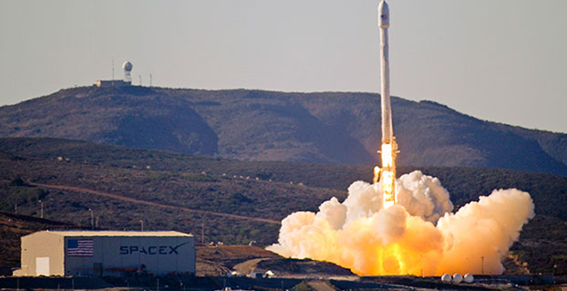
The Falcon .9 (Courtesy of SpaceX)
SpaceX
With ULA out of the picture, at least temporarily, for GPS III launches, this leaves the door open for Elon Musk, recently of Big Bang Theory fame, and his Space Exploration Technologies Corporation better known as SpaceX to step in and fill the void presumably with a variation of their heavy lift Falcon 9 rocket.
SpaceX promotes itself as the largest private producer of rocket engines worldwide, and no doubt that is true. SpaceX has demonstrated the capability for both successful launches and spectacular failures. That is almost to be expected for a new rocket engine and a new company, which only came about in 2002. However, where human lives are concerned, failure is not an acceptable option.
SpaceX is very much aware that a launch failure resulting in lives lost might well spell the end of SpaceX. With that as a given, SpaceX recently delivered its 100th Merlin 1D engine, nine of which form the basis for the first stage of the Falcon 9 launch vehicle. Indeed, SpaceX touts unparalleled redundancy — with nine Merlin 1D engines on the first stage, it could actually overcome a failure of any one of the Merlin engines and still have a successful launch.
Merlin ID engines all in a row. (Courtesy of SpaceX)
Only time will tell, however, and this scenario leaves the U.S. government with very few options as long as the current guidelines regarding the Russian RD-180 core are in place. Other companies such as Moog, Orbital Sciences, Aerojet Rocketdyne, Blue Origins and ATK, to name a few potential contenders, could separately or as a team bid on the next-generation launch vehicle for GPS III.
However, that would mean storing the GPS III satellites and payloads for inordinately long periods of time, which is both expensive and risky. Expensive in dollars, since each GPS III space vehicle (SV) would cost approximately $1 million per year — not an official figure, but a best guess from several sources, to store, and expensive and risky from an operational point of view in that the federal government and LMCO would have no idea if the GPS III SVs and payloads really worked as advertised.
They would have no idea if there were any major flaws or anomalies, and once the production line at LMCO space systems was shut down, it would be prohibitively expensive to restart, if that were even possible. Remember, three GPS III SVs are being constructed currently, and today there are only eight confirmed orders for GPS III SVs.
As for major anomalies, just think back to the GPS IIF launches where the first four each revealed a major and separate anomaly for IIF SVs that had to be corrected on all future SVs and payloads before further launches occurred.
My sources at LMCO in Littleton assure me the first GPS III SV with a complete payload, built by Harris nee Exelis, nee ITT, will be ready for delivery to the government in mid-2016, possibly earlier. With a 90-day checkout the first GPS III SV could be ready for launch as early as late fall 2016.
The problem at that point becomes — and actually is a problem right here and now — there is no evidence that the government currently has a viable certified program to launch, control or maintain the GPS III satellites and payloads. But that is another story with many twists and turns.
The Road Less Taken
Apparently, there are numerous options for the government where GPS programs are concerned, and for a change many of those options, while being considered outside the box, actually appear to be the smarter choice.
As that great American poet Robert Frost once famously wrote:
“I shall be telling this with a sigh
Somewhere ages and ages hence:
Two roads diverged in a wood, and I—
I took the one less traveled by,
And that has made all the difference.”
Until next time, Happy Holidays, Happy New Year and Happy Navigating on that road less traveled by.
The U.S. Air Force released a final Request for Proposal (RFP) for GPS III Launch Services on Sept. 30. Launch services include launch vehicle production, mission integration and launch operations for a GPS III mission scheduled to launch in 2018. Proposals are due back to the Air Force no later than Nov. 16 in accordance with the solicitation instructions.
After evaluating proposals through a competitive, best-value source selection process, the Air Force will award a firm-fixed price contract that will provide the government with a total launch solution for the GPS III satellite. The Air Force’s acquisition strategy for this solicitation achieves a balance between mission success, meeting operational needs, lowering launch costs, and reintroducing competition for National Security Space missions, according to a statement by the Air Force.
“Through this competitive solicitation for GPS III launch services, we hope to reintroduce competition in order to promote innovation and reduce cost to the taxpayer while maintaining our steadfast laser focus on mission assurance and assured access to space,” said Lt. Gen. Samuel Greaves, Space and Missile Systems Center commander and Air Force Program Executive Officer for Space.
This will be a standalone contract for one GPS III launch, the Air Force said. This is the first of nine competitive launch services planned in the FY 2016 President’s Budget Request under the current Phase 1A procurement strategy, which covers awards with FY 2015-2017 funding. The next solicitation for launch services will be for a second GPS III mission.
The Phase 1A procurement strategy reintroduces competition for national security space launch services. Under the previous Phase 1 strategy, United Launch Alliance (ULA) was the only certified launch provider. In 2013, ULA was awarded a sole-source contract for launch services as part of an Air Force “block buy” of 36 rocket cores that resulted in significant savings for the government through FY 2017.
In May, Space Exploration Technologies (SpaceX) was certified for EELV launches resulting in two launch service providers that are qualified to design, produce, qualify and deliver a launch capability and provide the mission assurance support required to deliver national security space satellites to orbit.
“With the recent certification of SpaceX, we now have multiple launch service providers that can service critical NSS missions. Reintroducing competition into EELV will ultimately save taxpayer dollars and increase assured access to space. ” said Claire Leon, director of SMC’s Launch Enterprise Directorate.
“As part of this reintroduction of competition, we’ve been working with our industry partners to develop and finalize this RFP,” said Leon. “Their feedback has been critical to developing the criteria for this source selection and how we are innovating government processes to better match commercial processes as directed by OSD’s Better Buying Power 3.0. This is an exciting time in NSS launch acquisitions.”
GPS III is the next generation of GPS satellites that will introduce new capabilities to meet the higher demands of both military and civilian users. GPS III is expected to provide improved anti-jamming capabilities as well as improved accuracy for precision navigation and timing. It will incorporate the common L1C signal which is compatible with the European Space Agency’s Galileo global navigation satellite system and compliment current services with the addition of new civil and military signals.
The Air Force Space Command’s Space and Missile Systems Center, located at the Los Angeles Air Force Base, Calif., is the U.S. Air Force’s center of excellence for acquiring and developing military space systems. Its portfolio includes the Global Positioning System, military satellite communications, defense meteorological satellites, space launch and range systems, satellite control networks, space based infrared systems and space situational awareness capabilities.
The Canadian government will begin providing search-and-rescue repeaters for the U.S. Air Force’s GPS III satellites, reports Space News. The repeaters provided by Canada’s Medium Earth Orbit Search and Rescue (MEOSAR) satellite project will significantly reduce the time it takes to locate a distress signal.
Canada’s Department of National Defence will begin negotiations with the U.S. Air Force to install 24 repeaters on GPS III satellites, starting with the 11th GPS III satellite. Canada’s MEOSAR satellite project includes construction of three ground stations, to be built by 2020.
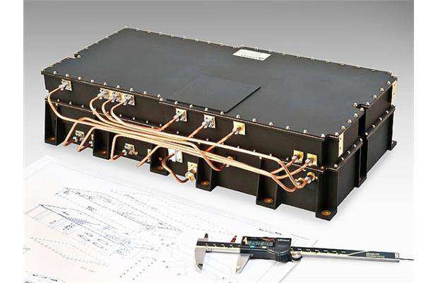
The MEOSAR satellite payload is being developed for GPS III satellites.
The Canadian government first announced the MEOSAR project in 2013, awarding Com Dev International of Cambridge, Ontario, an initial contract worth 4.7 million Canadian dollars for research and design work on the repeaters. Despite completion of that phase, Canada’s Department of National Defence put the project on hold, possibly for budgetary reasons.
A contract award for the MEOSAR repeaters is now expected to be announced next year.
A MEOSAR repeater will be able to detect signals from emergency beacons and retransmit the signals to receiver stations on the ground. The emergency messages can then be sent to appropriate authorities so that people in danger can be quickly located and rescued.
MEOSAR will provide a more capable system than COSPAS-SARSAT, an international satellite-based search and rescue distress alert detection system established by Canada, France, the former Soviet Union and the United States in 1979. It is credited with saving more than 33,000 lives since its inception. MEOSAR will reduce the time it takes to detect and locate a distress signal from an hour to around five minutes.
Com Dev began the development of its MEOSAR technology in 2008 under a cost-shared research and development project with the Canadian Space Agency. Canada’s National Search and Rescue Secretariat also later provided additional R&D support.
The search and rescue transponders were originally destined for Galileo, according to Space News, but stalled because Canada lacked a defense certificate to be able to supply the Galileo program.
On June 3, Raytheon demonstrated the advanced capabilities of the GPS Next Generation Operational Control System (GPS OCX) to key U.S. Department of Defense (DoD) and other stakeholders through a series of realistic operational demonstrations.
The demonstrations, which incorporated software that will be delivered with the Launch and Checkout System, validated how automation will improve system efficiency and effectiveness.
GPS OCX is the ground-based command and control system that will manage GPS satellites with significantly improved accuracy and precision, while providing unprecedented levels of cyber protection.
“These successful demonstrations incorporating actual GPS OCX software reflect Raytheon’s significant and continuing progress on this program and the growing maturity of this very complex system,” said Dave Wajsgras, president of Raytheon’s Intelligence, Information and Services. “Once delivered, this pathfinding, cyber-hardened ground system will significantly enhance the capabilities GPS brings to military, civil and commercial users worldwide,” said Wajsgras.
The demonstration provided DoD and other stakeholders with a look at how OCX will automate many tasks currently performed manually, resulting in reduced opportunities for error and increased operational tempo for delivering military and other applications, Raytheon said.
Raytheon demonstrated the benefits of OCX in providing new high-power, jam-resistant military signal known as M-code, as well as the system’s unprecedented cyber automation, detection and response capabilities.
Raytheon is installing the Block 0 Launch and Checkout System (LCS) hardware at Schriever Air Force Base. LCS software, which includes the cyber-hardened infrastructure for OCX Block 1, is in the qualification test phase and is on track for delivery in mid-2016.
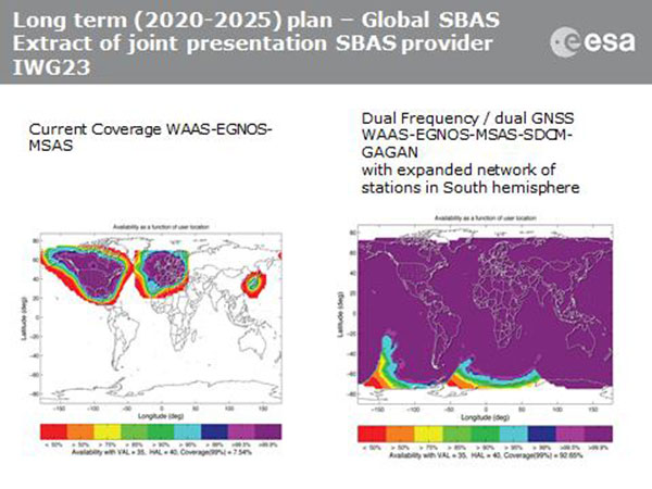
Current coverage (left) of WAAS, EGNOS and MSAS; long-term 2020–2025 (right) plan for dual-frequency, dual-GNSS WAAS-EGNOS-MSAS-SDCM-GAGAN.
SBAS Agree to Common Message
Aircraft navigation and safety will benefit from enhanced, reliable satellite navigation signals on a seamless basis across much of the world in the 2020–2025 timeframe. The 28th Satellite-based Augmentation Systems Interoperability Working Group (IWG) came to agreement on standardization of satellite-based augmentation systems (SBAS) in a meeting hosted by the European Space Agency in early April. The group planned a shift from reliance exclusively on GPS to a multi-constellation design employing Galileo, BeiDou and GLONASS after 2020.
The agreement centers around a message definition for a new secondary SBAS channel — to be known as L5, along with the current L1 — for second-generation SBAS systems, which will utilize dual-frequency multi-constellation signals, greatly increasing the accuracy of navigation systems available to airliners by largely eliminating ionospheric errors. Plans also call for an expanded network of stations in the Southern Hemisphere. The IWG document must now be accepted by the official international SBAS standardization bodies: the International Civil Aviation Organisation, the U.S. Radio Technical Commission for Aeronautics (RTCA) and the European Organisation for Civil Aviation Equipment.
The meeting also reported on the state of development of the other global SBAS systems. Along with the four operational systems — the U.S. WAAS, European EGNOS, Japan’s Multi-functional Satellite Augmentation System (MSAS) and India’s GAGAN (GPS and geo-augmented navigation system) — these comprise South Korea’s KASS, China’s Beidou SBAS, Russia’s System for Differential Corrections and Monitoring (SDCM) and the West African Agency for Aerial Navigation Safety in Africa and Madagascar (ASECNA) SBAS.
UAV Integration into Airspace
The Federal Aviation Administration (FAA) announced two new initiatives related to unmanned aircraft systems (UAS) at the Association for Unmanned Vehicle Systems International (AUVSI) Unmanned Systems 2015 conference in Atlanta, Ga., in early May.
FAA Administrator Michael Huertatold a large gathering of national journalists, “The unmanned aircraft industry is changing faster than any segment in the aircraft industry. A new project to harness that energy, the Pathfinder program, is partnering with three leading U.S. companies to expand unmanned aircraft operations in the United States.” The FAA is working with industry partners on three focus areas:
CNN will research visual line of sight (LOS) operations for newsgathering in urban areas. CNN will continue working with Georgia Tech University to improve newsgathering for all organizations.
PrecisionHawk will investigate agricultural operations for rural areas, flying outside LOS.
BNSF Railway, second-largest freight railroad network in North America, will undertake inspection of rail infrastructure, also beyond visual LOS.
Huerta said that the partners, collectively, “are trying to push the envelope, what can we accommodate safely and what can we learn from that.We’ll test a little, learn a little, then test some more. How do we see a staged implementation? To integrate unmanned aircraft, but to do it safely. We’re trying to push the edges of what we can allow, working with partners who have specific uses and resources.”
As to a timeframe to reach new UAV regulations, he replied, “I can’t comment a lot on the rule itself, but it’s fair to say that in the rulemaking comment process [closed on April 24], we received more than 4,500 comments. It’s too early to say how those comments will shape the final rulemaking.
“Assessment will be done in the coming months, perhaps by the end of the year, but that’s an aggressive timetable. That’s not accomplished in six months, nor should it take a million years.”
New Airbus EGNOS-Capable
The new Airbus A350 airliner, now entering service, comes fitted with EGNOS. The EGNOS system is being adopted by European airports to enable satellite-guided landing approaches. The A350’s Satellite Landing System allows pilots to perform precision-landing approaches guided by EGNOS or its U.S. equivalent, WAAS. The capability offers vertical landing guidance down to a minimum of 60 miles.
New Galileo Satellite on the Air
Monitoring by researchers at the German Aerospace Center (Deutsches Zentrum für Luft- und Raumfahrt, or DLR) indicates that one of the Galileo full-operational-capability (FOC) satellites launched on March 27 has begun transmitting standard L-band signals using pseudorandom-noise-code identifier 22.
The first E1 and E5 signals from GSAT0204, also known as FOC-FM4 and Galileo 8 and as NORAD object 40545, were received at an International GNSS Service Multi-GNSS Experiment tracking station in Windhoek, Namibia, at about 11:32 UTC May 21. The satellite’s signals were subsequently tracked by a station in Wettzell, Germany, and then by others.
The signals will be set unhealthy for use until satellite commissioning is completed.
News item courtesy of CANSPACE Listserv.
Euroship Gets eLoran as Backup
Container ship in port.
Ship management company EuroShip Services Ltd. has installed eLoran as a backup to GPS to ensure the safety of its vessels operating off the coast of the United Kingdom.
The trial installation may lead to implementation across the full fleet of16 vessels managed by Euroship, working routes in Northern Europe. The land-based radio navigation system is intended to seamlessly take over in the event of a GPS outage. EuroShip plans to simulate GPS outages to test eLoran provision of position, navigation and timing data automatically.
New GPS III RFP
The U.S. Air Force (USAF) has released a draft Request for Proposal for GPS III Launch Services, encompassing launch vehicle production, mission integration and launch operations.USAF reintroduces competition into the Evolved Expendable Launch Vehicle (EELV) program after more than a decade.
GPS III is the first of nine launches the Air Force intends to competebetween now and 2017, followed by 25 more from 2018 to 2022.
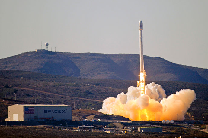
Team Vandenberg launches its first SpaceX launch from Space Launch Complex-4 Sept. 29, 2013. 30th Space Wing’s 1st Air and Space Test Squadron was the lead for all launch site certification activities at Vandenberg for SpaceX as an EELV New Entrant. The squadron evaluated SpaceX’s flight and ground systems, processes and procedures for the upgraded Falcon-9 rocket. (U.S. Air Force photo/Airman Yvonne Morales)
The U.S. Air Force has certified SpaceX’s Falcon 9 rocket to launch military satellites, clearing the way for SpaceX to bid on launches of GPS III satellites. The Air Force announced the decision May 26, which completed a nearly two-year process and establishes a competitor to United Launch Alliance.
SpaceX, based in Hawthorne, Calif., is now eligible for award of qualified national security space launch missions as one of two currently certified launch providers. The first upcoming opportunity for SpaceX to compete to provide launch services is projected to be in June when the Air Force releases a Request for Proposal for GPS III launch services.
“This is a very important milestone for the Air Force and the Department of Defense,” said Secretary of the Air Force Deborah Lee James. “SpaceX’s emergence as a viable commercial launch provider provides the opportunity to compete launch services for the first time in almost a decade. Ultimately, leveraging of the commercial space market drives down cost to the American taxpayer and improves our military’s resiliency.”
This milestone is the culmination of a two-year effort on the part of the Air Force and SpaceX to execute the certification process and reintroduce competition into the Evolved Expendable Launch Vehicle (EELV) program. The Air Force invested more than $60 million and 150 people in the certification effort which encompassed 125 certification criteria, including more than 2,800 discrete tasks, three certification flight demonstrations, verifying 160 payload interface requirements, 21 major subsystem reviews and 700 audits in order to establish the technical baseline from which the Air Force will make future flight worthiness determinations for launch.
“The SpaceX and SMC teams have worked hard to achieve certification, said Lieutenant General Samuel Greaves, commander of the Air Force Space and Missile Systems Center. “And we’re also maintaining our spaceflight worthiness process supporting the National Security Space missions. Our intent is to promote the viability of multiple EELV-class launch providers as soon as feasible.”
“This is an important step toward bringing competition to National Security Space launch. We thank the Air Force for its confidence in us and look forward to serving it well,” said Elon Musk, SpaceX CEO and lead designer.
The certification process provides a path for launch-service providers to demonstrate the capability to design, produce, qualify and deliver a new launch system and provide the mission assurance support required to deliver national security space satellites to orbit. This gives the Air Force confidence that the national security satellites being delivered to orbit will safely achieve the intended orbits with full mission capability.
The SMC, located at Los Angeles Air Force Base, Calif., is the U.S. Air Force’s center for acquiring and developing military space systems. Its portfolio includes GPS, military satellite communications, defense meteorological satellites, space launch and range systems, satellite control networks, space based infrared systems and space situational awareness capabilities.
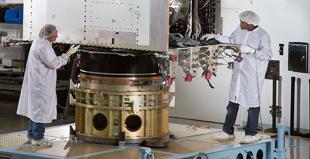
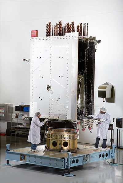
First Photo a GPS III Satellite: In April, Lockheed Martin fully integrated the U.S. Air Force’s first next-generation GPS III satellite. GPS III Space Vehicle One is now preparing for system-level testing this summer.
Using a 10-ton crane, Lockheed Martin engineers and technicians gently lowered the system module of the U.S. Air Force’s first next generation GPS III satellite into place over its propulsion core, successfully integrating the two into one space vehicle.
The April systems integration event brought together several major fully functional satellite components. The system module includes the navigation payload, which performs the primary positioning, navigation and timing mission. The functional bus contains sophisticated electronics that manage all satellite operations. The propulsion core allows the satellite to maneuver for operations on orbit.
“The final integration of the first GPS III satellite is a major milestone for the GPS III program,” said Mark Stewart, vice president of Lockheed Martin’s Navigation Systems mission area. “This summer, SV 01 will begin Thermal Vacuum testing, where it will be subjected to simulated harsh space environments. Successful completion of this testing is critical as it will help validate our design and manufacturing processes for all follow-on GPS III satellites.”
Lockheed Martin is under contract to build eight GPS III satellites at its GPS III Processing Facility near Denver, a factory specifically designed to streamline satellite production.
GPS III space vehicle one (SV 01) is the first of a new, advanced GPS satellite design block for the Air Force. GPS III will deliver three times better accuracy, provide up to eight times improved anti-jamming capabilities, and extend spacecraft life to 15 years — 25 percent longer than the satellites launching today. GPS III’s new L1C civil signal also will make it the first GPS satellite interoperable with other international global navigation satellite systems.