DeltaQuad has successfully integrated an advanced GPS anti-jamming system into its unmanned aerial vehicle (UAV). The DeltaQuad drone equipped with the system was flown in autonomous mode close to an active military jamming system.
Even while being hit directly by a military-grade GPS jamming platform, the system maintained a solid GPS lock and the vehicle managed to autonomously resume its mission without interruption.
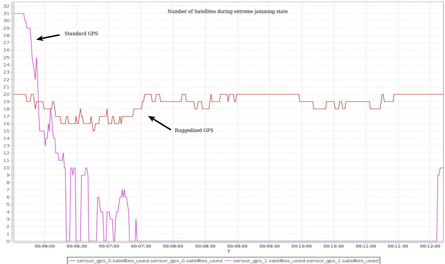
For testing purposes, a ruggedized GPS-based navigation system was installed with the standard GPS-based navigation system. As the vehicle came in range of the GPS jamming system, the standard solution quickly lost all positional awareness, while the ruggedized system maintained a number of satellite locks, even while flying directly over the jammer at close range.
Test results. (Image: Deltaquad)
In addition to the ruggedized GPS solution, the DeltaQuad UAV is equipped to maintain live aerial intelligence, even in tough environments. The transmission system on the DeltaQuad uses frequency hopping spread spectrum (FHSS) techniques to mitigate attempts to disrupt the communication links, and also uses redundant video and communication links.
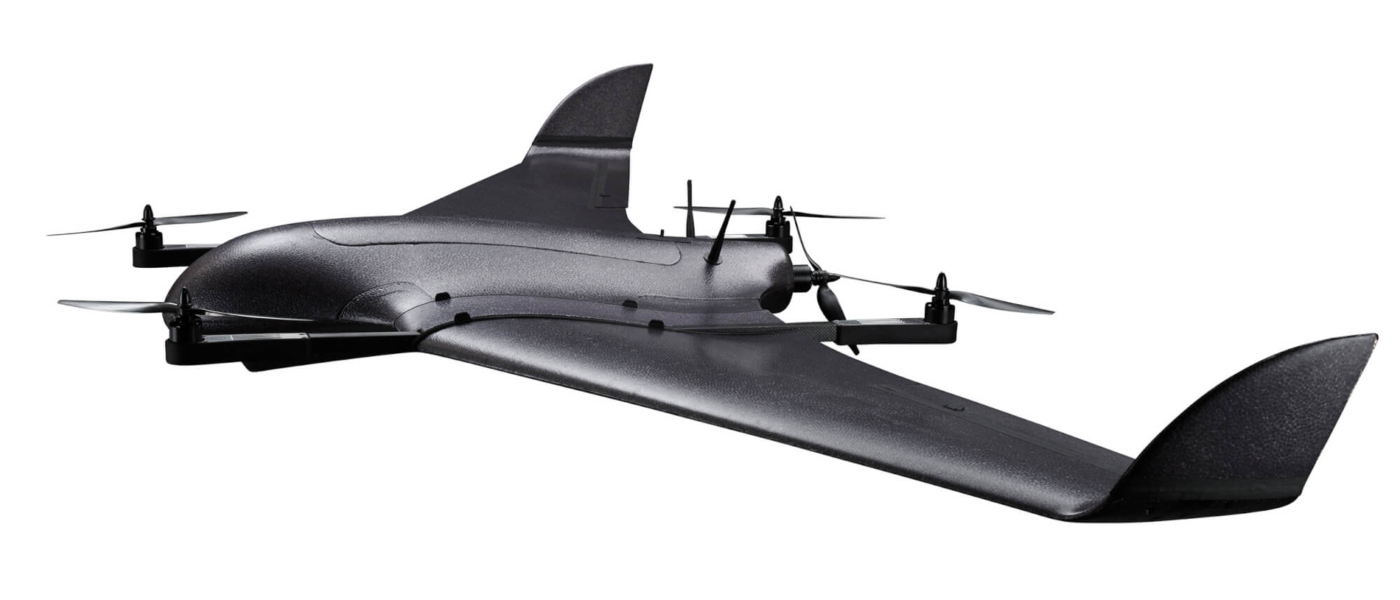
The DeltaQuad is an industrial-grade vertical takeoff and landing (VTOL) fixed-wing UAV that performs fully autonomous surveillance missions. The platform offers a live video stream from a surveillance sensor for real-time reconnaissance missions.
BAE Systems has expanded the capabilities of its Digital GPS Anti-Jam Receiver (DIGAR) by enabling beamforming with Trimble receivers, in addition to its own receivers.
DIGAR’s beamforming capabilities increase the level of GPS jamming protection for aircraft by a million-fold, helping pilots execute their missions in contested environments.
BAE Systems’ engineers in Cedar Rapids, Iowa, developed software to ensure the compatibility of its antenna electronics with industry-standard embedded GPS inertial navigation system (GPS/INS) technology, enabling fast communication with transmitter electronics for superior beamforming.
DIGAR beamforms with both BAE Systems receivers and Trimble GPS receivers embedded in aircraft GPS/INS, as well as federated GPS systems and stand-alone GPS receivers.
“The modern battlespace has evolved, and peer state positioning, navigation, and timing threat systems are challenging our ability to conduct combat operations in the place and manner of our choosing,” said Greg Wild, director of Navigation and Sensor Systems at BAE Systems. “By combining DIGAR’s beamforming with trusted inertial navigation system data, we offer the highest level of jamming protection available today.”
DIGAR is a high-performance military GPS-based system for fixed-wing, rotary-wing and unmanned airborne platforms. It combines field-proven antenna electronics, advanced signal-processing, and beamforming techniques to improve the reliability of positioning, navigation and timing data in the presence of disruptive electromagnetic signals.
DIGAR is also compatible with the advanced M-code – delivering additional security to the warfighters who rely on it.
BAE Systems’ anti-jamming GPS technology has defeated powerful and sophisticated adversary threat systems in testing and combat, and is available for airborne, shipborne and ground vehicle applications. The company’s military GPS business is based in Cedar Rapids, Iowa, where it is building a 278,000-square-foot state-of-the-art research and manufacturing facility scheduled to open this year.
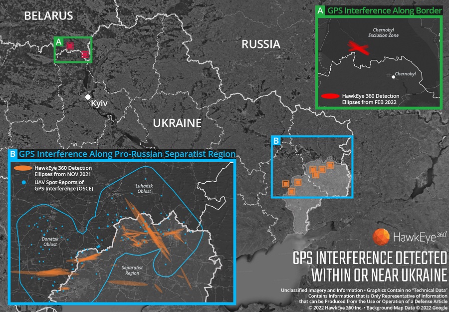
Technology from HawkEye 360 Inc. has detected and geolocated extensive GPS interference over Ukraine, starting months before the Russian invasion. HawkEye 360 uses satellites to monitor radio-frequency signals that might threaten military and civil navigation applications.
The capability was tested in 2021 in a variety of exercises and is available as part of HawkEye 360’s RFGeo signal product catalog.
When HawkEye 360 analysts examined Ukraine over the past five months, they discovered continued and increased GPS interference across the region. The data showed extensive GPS interference in November 2021 along the boundary of the pro-Russian separatist-controlled regions in Luhansk and Donetsk.
Open-source information confirmed unmanned aerial vehicles (UAVs) operating in the area were disrupted because of lost GPS connections.
In February 2022, HawkEye 360 detected GPS interference along the border between Ukraine and Belarus, shortly before the Russian invasion started. This February activity occurred north of Chernobyl within the Chernobyl Exclusion Zone, demonstrating the integration of electronic warfare tactics into Russian military operation to further degrade Ukraine’s ability for self-defense.
“GPS is a fundamental ‘global commons’ service that all modern economies depend upon. GPS signal interference has the potential to significantly disrupt air travel, logistics, finance, transportation, communication and many other basic services,” said John Serafini, CEO of HawkEye 360.
“Whether unintentional or deliberate, interference that prevents people, vehicles, ships, and planes from determining accurate locations can be devastating to government and commercial activities alike,” Serafini said. “Since HawkEye 360 can monitor hundreds of millions of square kilometers daily, we are able to notify clients when and where GPS interference occurs, so they can respond quickly to mitigate the impacts.”
Interference can be inadvertent by equipment operating too close to GPS frequency bands. However, deliberate interference has spiked across the globe due to the low cost, ease of deployment, and general availability of GPS jamming technology.
Military forces use GPS jammers to obscure and protect critical troops, facilities and equipment from attack and can be a leading indicator of future military activity. Drug cartels use GPS jammers to deter surveillance from overhead drones. Use of jammers is illegal in most developed nations.
HawkEye 360’s detection product offers a valuable capability to monitor for illicit and unintentional GPS interference that can significantly disrupt critical location services, representing the company’s global commitment to make the world a safer place, the company said.
The Russian military has disrupted flight systems in three regions since the invasion of Ukraine, highlighting the need for robust alternatives, according to a French safety regulator and as reported by Bloomberg.
Airline pilots have reported jamming of satellite navigation systems around the Black Sea, eastern Finland and the Kaliningrad enclave, said Benoit Roturier, head of satellite navigation at France’s civil aviation authority DGAC.
The jamming signals appear to originate from Russian trucks intent on protecting troops and installations against GPS-guided missiles. While the signals are not aimed at civil aviation, however, they force the pilots to deal with distracting alerts.
“Airplanes hit by jamming can continue to fly using inertial navigation systems — that is standard and works with GPS,” Roturier said. “This could be less accurate, but can be used when GPS goes down.” Yet regulators are realizing the potential for massive airspace disruptions, especially as the European Union pushes for increasing reliance on satellite navigation.
Spire Global Inc., a provider of space-based data, analytics and space services, is using its constellation of about 40 geolocation satellites to detect GPS jamming. Spire is collecting data for use by the U.S. Space Force, a particularly important task in light of Russia’s invasion of Ukraine.
“All of our fellow space companies… everyone is playing a vital role for humanity in this battle for freedom and democracy,” Spire CEO Peter Platzer told analysts March 9 in an earnings call, according to Space News.
In September 2021, Spire won a contract to supply Slingshot Aerospace with GPS telemetry data. Slingshot’s pLEO Data Exploitation and Enhanced Processing (DEEP) prototype will automate manual data exploitation techniques to deliver intuitive, easily digestible data products at low latencies for military operations.
The DEEP prototype contract is funded through the the Commercially Augmented Space Inter-Networked Operations (CASINO) program of the Space Systems Command (SSC), which develops and demonstrates the military utility of proliferated LEO satellite architectures.
Identifying and mitigating ground-based radio-frequency (RF) and GPS interferences is a critical component of national security and U.S. Space Force operations. RF signals intercepted in open airspace are liabilities that directly threaten on-orbit space assets and military missions.
Even in the absence of enemy interference and intentional jamming, RF signals from radio stations, cell phones, and various electronics cause interruptions and interferences — a problem exacerbated by the growth of modern communications technology.
The DEEP prototype is an effort by the U.S. military to take advantage of existing commercial satellite telemetry data to readily identify these sources of interference and correct any potential problems before they become a threat.
Spire’s cubesats use GPS radio occultation, a remote sensing technique that measures properties of the Earth’s atmosphere from space.
U.S. forces have detected Russian jamming of GPS signals in the Ukraine region, according to Breaking Defense. But Pentagon officials say the jamming has not affected U.S. support operations.
U.S. reconnaissance aircraft have detected jamming over the Black Sea, but when asked about Russian jamming, a U.S. Space Command spokesperson told Breaking Defense, “There are no impacts to U.S. and Allied forces in Europe at this time.”
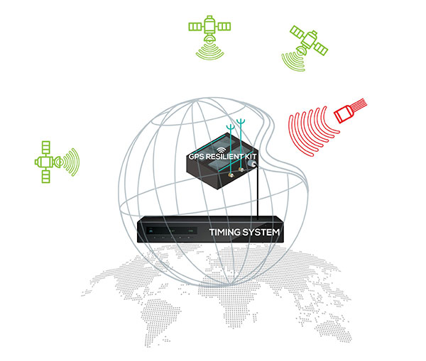
ViaLite’s RF-over-fiber systems can carry GPS/GNSS timing signals over long distances with very low signal degradation. However, the same cannot be said of GPS signals before they reach the GPS/GNSS antenna, as these weak radio waves are highly susceptible to jamming or spoofing.
Timing-critical infrastructures in areas such as defense and cyber security can now be protected from this kind of attack by installing one of ViaLite’s new GPS Protection Packages. The packages integrate either the GPS Resilient Kit or OtoSphere Protection Module products from Focus Telecom for jamming protection.
The GPS Resilient Kit has two GPS antennas, which enables the direction of the attack to be pinpointed. At its heart is the small OtoSphere Protection Module, which has a unique interference filtering algorithm that combines the patterns from the two omnidirectional antennas.
The module can analyze the direction from which the interference is coming and feed it into its algorithm, directing a null towards the unwanted signal to reject and reduce disruptions.
Using OtoSphere, GPS receivers are up to 50 times more resilient to jamming attacks on positioning, navigation and timing (PNT) systems compared with having no protection. The GPS receiver is able to continue working normally throughout the attack.
“ViaLite customers typically need the highest grade of reliability and service, particularly for critical infrastructure timing applications,” said Richard Jacklin, ViaLite sales director. “With the increase in jamming threats, both land-based and maritime, these Focus Telecom anti-jamming products are a perfect complement to our range of GPS/GNSS signal distribution solutions.”
The Protection Packages can be integrated into new installations or retrofitted to existing ViaLite systems. The GPS Resilient Kit and OtoSphere are already IP-rated, so they can be simply added to outdoor installations. Alternatively, for a full package solution, the OtoSphere module can be integrated into the ViaLite ODE-MINI outdoor enclosure.
The packages are suitable for use in critical infrastructure sectors such as defense, satcoms, utilities, cellular communications, broadcast, data centers and transportation.
Other Focus Telecom products, introduced by ViaLite, include the GPSensor for monitoring GPS frequencies and reporting intentional and unintentional attacks, and the GPS RF Switch which protects PNT systems from vulnerabilities by isolating them from the RF signals coming from the antenna.
It said policymakers “could consider selecting the most resilient technologies as the cornerstone of the PNT suite for military missions, rather than defaulting to GPS.”
The 51-page report takes a comprehensive view of alternative PNT policy and leadership across the department. Its findings are an interesting and informative look at issues and efforts.
Increasing demands
The report comes at a time when U.S. forces have been seeing increasing interference with their own and allied GPS-enabled systems. The Organization for Security and Cooperation in Europe has regularly reported that its surveillance drones in the Ukraine have been jammed. Chinese press recently bragged that jamming caused U.S. Navy ships in the South China Sea to switch from using GPS to the Chinese BeiDou system. Additionally, U.S. military commanders have regularly described the Middle East as the most contested electronic warfare area on the planet, in large part because of regular interference with GPS signals.
The GAO study also comes on the heels of a provision in the National Defense Authorization Act (NDAA) for this year which directs DOD to provide non-GPS PNT to combatant commanders by 2023. The act says this timeline is consistent with responding to Joint Urgent Operational Needs, a formal method for commanders to communicate with department leadership. According to some sources, this suggests that the Pentagon has been receiving such requirements from field commanders, but has not responded to them in what Congress considers a timely manner.
Alternative PNT “not a priority,” resisted
Despite chronic GPS signal interference across the globe, outside experts and officials across the DOD told the GAO study team that developing alternative sources of PNT was not a priority for DOD. One example cited was the lack of a central program office.
One expert said, “PNT — It’s everyone’s need, but nobody’s business.” Another expert said, “Everyone wants to use [PNT], no one wants to pay or care for [PNT].” One DOD official characterized alternative PNT as an afterthought. DOD’s PNT Roadmap states that PNT capabilities, despite being mission critical, are not normally considered a key requirement, but rather may be treated as “a second-tier requirement.”
Worse, the report indicated that some forces within the department resist alternative PNT efforts.
According to one DOD official cited anonymously in the report “bureaucratic and political obstacles [represent] the biggest challenges for alternative PNT” and “anything that threatens GPS, such as alternative PNT technologies, faces pushback.”
The report cited another DOD official as agreeing that “there is an impression that the GPS program has a lot of political clout within DOD, and that those trying to develop alternative PNT technologies may face political challenges.”
Realistic requirements
Many missions do not need the accuracy provided by GPS, according to the report. Nevertheless. DOD programs often default to GPS performance standards when developing requirements. Many alternative technologies, while more resilient, are unable to achieve the same accuracy as GPS and therefore fail to meet the over-stated requirements.
Open architecture
Both DOD and GAO see development of modular open system architecture (MOSA) as key to PNT success in the future. This will allow addition of new PNT sources to a platform without the need for a major retrofit. With MOSA, all that would be needed is a new sensor module for the desired PNT source.
The GAO report endorsed this approach and encouraged DOD to institutionalize it with dedicated funding.
Working with industry
Decades of civil GPS use have benefited DOD in many ways. Broad academic and commercial research has resulted in a host of applications and improvements in the size, weight, and power requirements of equipment, as well as lowered costs. These benefits would almost certainly not have been realized at the current scale if the market for GPS equipment and apps had been restricted to military users.
The 2021 NDAA directs the department to “…enable civilian and commercial adoption…” of the GPS alternative technologies it develops for field commanders. The GAO report suggests DOD also work to leverage industry advances in technologies.
Scope and recommendations
GAO’s tasking for this effort did not include examining efforts to make GPS signals and equipment more resilient to disruption, nor use of non-U.S. satellite navigation systems. Neither were non-defense uses of PNT, nor improvements in such things as tactics, techniques, and procedures considered.
The study focused solely on department efforts to complement GPS services.
Six recommendations for policymakers are included in the report:
Increase Collaboration — Consider mechanisms to coordinate across DOD to clarify responsibilities and authorities in prioritizing the need for alternative PNT technologies.
Focus on Resiliency — Consider selecting the most resilient technologies as the cornerstone of the PNT suite for military missions, rather than defaulting to GPS.
Clarify Requirements — Consider opportunities to clarify what level of PNT performance is actually needed for missions, rather than defaulting to requirements that match GPS performance.
Coordinate with Industry — Consider ensuring that DOD and commercial industry coordinate so that industry is prepared to meet DOD’s needs, and DOD can leverage industry advances.
Institutionalize Open Architecture — Consider making the open architecture initiative more permanent, including providing funding.
Analyze Vulnerabilities — Consider having DOD conduct ongoing analysis of vulnerabilities of different PNT systems.
The May 2021 GAO report “Defense Navigation Capabilities: DOD is Developing Positioning, Navigation, and Timing Technologies to Complement GPS” is available here.
The NTS-3 experimental satellite will be launched in 2023, according to reports from C4ISRNET and Space News. The United States military will use the satellite for positioning, navigation and timing (PNT) as a supplement to GPS.
The satellite was originally set to launch in 2022.
The Air Force Research Laboratory (AFRL) plans to use the additional time to reduce risks and conduct more ground testing.
Navigation Technology Satellite 3 will help guide future GPS satellites, a priority area for the military as the technology has become easier to spoof and jam. Among other features, NTS-3 will have steerable beams for regional coverage and a software-defined payload that can be reprogrammed on orbit.
AFRL discussed the delay in a media roundtable held Wednesday, reports C4ISRNET. AFRL Commander Brig. Gen. Heather Pringle said that shift was out of the lab’s control since the satellite will launch as a rideshare with a U.S. Space Force payload, and that launch had been pushed back.
AFRL plans to experiment with the satellite in geosynchronous orbit for one year, testing PNT signals and architectures as well as ground-based command and control systems and software-defined radios. Following testing, NTS-3 will transition to the U.S. Space Force and integrate into the service’s other PNT capabilities.
Are military tests that jam and spoof GPS signals a threat to the safety of civil aviation? If not, why? If so, who should do what about it?
Bernard Gruber
“I would offer that military tests that jam and spoof signals are a risk. The U.S. military takes great care to control tests of this nature in an informed and careful way in order not to affect civil aviation. I cannot speak for military tests that are conducted by other countries. We all recognize the worldwide proliferation of small and large jammers that can negatively affect GPS performance and satellite-born transmissions. Accordingly, GPS users should remain vigilant to these potential hazards, including spoofing, and consider alternative navigation means where risks dictate.” — Bernard Gruber
What are the remaining obstacles to creating a seamless indoor/outdoor positioning and navigation system that integrates data from GNSS, inertial guidance, indoor positioning systems, and signals of opportunity?
John Fischer
“The primary use case for indoor navigation is the smartphone. We can create multi-sensor navigation systems today that operate indoors, but not at the very small size, weight, power, and cost targets needed for the personal phone market. IMUs and processors continue to improve over time, so there may be a breakthrough there, but signals of opportunity (SoOP) navigation is promising and offers resiliency through diversity. The most ubiquitous SoOP is cellular and with ultra-reliable low latency (URLL) features coming on-line for 5G in the next few releases, we may see reliable positioning from 5G in indoor environments very soon.” — John Fischer
Two recent reports from the Organization for Security and Co-operation in Europe (OSCE) have described a recent increase in GPS jamming, presumably by Russian or pro-Russian forces in Ukraine. This comes as Russia has increased its troop numbers and activity along its border with Ukraine.
OSCE is charged with a Special Monitoring Mission (SMM) in Ukraine which observes and reports on how well both sides are adhering to the Minsk Protocol agreement. The agreement was signed in September 2014 by participants in the conflict in an effort to end open hostilities.
One of the ways the OSCE mission monitors activity and compliance in the region is with long range UAVs. As early as November 2014, the organization reported UAV operations being thwarted by interference with GPS signals.
Two recent OSCE spot reports have highlighted a resurgence in jamming.
An April 7 report described interference that prevented a UAV takeoff the previous day. While the organization’s UAVs had been experiencing increased interference since March, this was the first time since October 2014 that it had thwarted a mission before takeoff.
The report also documented an increasing level of jamming activity.
“Over the last two months, 62.5 percent of SMM long-range UAV flights encountered GPS signal interference and on 75 percent of the affected flights it occurred more than once.”
A second report on April 9 outlined continuing problems that caused missions to be aborted. It emphasized that this was a violation of the agreement signed by all parties and greatly hampered OSCE’s mission.
“Any GPS signal interference hinders the Mission’s ability to conduct effective monitoring and reporting of the security situation in line with its mandate. Long-range UAVs are an essential part of SMM operations, especially at night and in areas where the Mission’s monitoring and freedom of movement are restricted.”
GPS jamming and spoofing are important parts of Russia’s arsenal to counter any technological advantage the west may have over their forces. A 2015 Sputnik article bragged their electronic warfare kept U.S. cruise missiles from hitting their targets at the start of the 2003 invasion of Iraq. Also, that this advanced capability “renders aircraft carriers useless.”
Interference with GPS signals is a regular feature of Russian military and internal security operations.
The United States has formally expressed concerns about the recent increase in the number of Russian troops and their activity at the Ukrainian border. It has been reported that two U.S. Navy ships are on their way to the Black Sea to help monitor the situation.
Dana A. Goward is president of the Resilient Navigation and Timing Foundation.
What should the new administration’s priorities be to make PNT more resilient?
We asked Brad Parkinson, the “Father of GPS” and a GPS World Editorial Advisory Board member, what the new U.S. administration’s priorities should be to make positioning, navigation and timing (PNT) more resilient. For more answers from board members, see below.
Brad Parkinson
Protect the Spectrum. Reverse FCC authorization for relatively high-powered Ligado transmitters that have been proven to degrade GPS and other GNSS operation for thousands of PNT users. All U.S. government departments and major user groups affected have pleaded with the FCC to reverse this terrible decision. There is little benefit from it to the American public.
Protect the rapidly evaporating and self-proclaimed Gold Standard of GPS. The GPS satellite designs are showing their age. They need to go to multiple launch (three at a time) and revert to simpler designs without the spot-beams and other weighty add-ons that greatly increase complexity and cost. The Chinese have added to BeiDou (a) inter-satellite precision ranging and wide-band communications, (b) geosynchronous satellites, probably with good spot-beam acquisition aids, and (c) a WAAS-like correction directly on the satellites, which may have accuracies down to real-time kinematic (RTK, perhaps a few centimeters). Also, they claim their basic accuracies to be better than GPS (it might be true!) — I think they already have operational retro-reflectors.
Allow and encourage export of the basic and quickest fix to jamming and spoofing for high-value PNT users. More than 40 years ago, we demonstrated, in hardware, a high anti-jamming receiver that could fly directly over a 10 kW GPS jammer and not be affected. We know that high-gain, digital beam-steering antennas will create close to immunity, but our manufacturers will not move this way because we cannot sell or use them on the international market.These devices, combined with inexpensive inertial components and the newer signals, would make PNT virtually immune to current threats of interference — both jamming and spoofing.
Move the military focus from alternative PNT techniques to seriously upgrading their receivers and useful signals. No current or reasonably anticipated alternative can provide the accuracy (3D), availability or integrity of GPS. The new M-code and L1C signals have been in the queue for about 20 years. (Loran for ground operations probably is very vulnerable to direct attack in a fluid battlefield operation. Loran’s main value is to distribute time and for maritime users.) In those 20 years, we now have cellphone chips costing less than $5 that can listen to about 200 ranging signals and process RTK, as well as use all the corrections available (WAAS, EGNOS, etc.). Such capability cannot be found in military receivers. The Defense Department must improve its acquisition strategy in terms of both speed and competition, and ncorporate existing civil capability into military user equipment.
Take government actions to rapidly identify, shut down, and prosecute GPS jammers. Some believe this problem is much larger than recognized already. All cellphones should be required to report extraordinary spectrum noise levels or apparent attempts at spoofing. This should be fed to a dynamic national database, perhaps maintained by the Coast Guard. GPS users should have an automated way to find out whether there are substantial threats in their operating area.
Brad Parkinson is the Edward Wells Professor, Emeritus, Aeronautics and Astronautics (recalled) and co-director of the Stanford Center for Position, Navigation and Time at Stanford University.
Editorial Advisory Board PNT Q&A
Here are additional responses to the question from more GPS World Editorial Advisory Board members.
John Fischer
“We hope the new administration continues on the path established with the Executive Order last year for resilient PNT, supporting progress made by DHS and NIST in establishing resilient and cybersecure frameworks. It will be important for them to maintain an open market concept toward future innovative solutions and not mandate a particular PNT approach. Awareness of the criticality for trusted PNT in our mobile connected society is established and we must not lose this.” John Fischer Orolia
Jules McNeff
“Resilient PNT should be a national security priority. Its continuity is vital to both military and economic/social activities of all kinds. Its qualities of spatial awareness and synchronization enable the efficient functioning of the most sophisticated modern technologies in the physical and cyber worlds while also simply getting people and things from point A to point B on schedule. In that context, the elements which comprise resilient PNT should be protected from natural or hostile disruption.” Jules McNeff Overlook Systems Technologies
Greg Turetzky
“Truly resilient PNT requires combining multiple positioning technologies to maximize resiliency. However, the government’s influence in many of the augmentation technologies (sensors, vision, etc.) is limited. What the administration can do is make GPS itself more resilient by speeding up the launch and acquisition schedule of GPS Block III. The new signals, particularly at L5, are invaluable for improved resiliency to jamming and spoofing as well as providing a significant improvement in accuracy.” Greg Turetzky Consultant