Tag: GPS jamming

  • How to defeat harmful GPS/GNSS interference: A roadmap for action

    How to defeat harmful GPS/GNSS interference: A roadmap for action

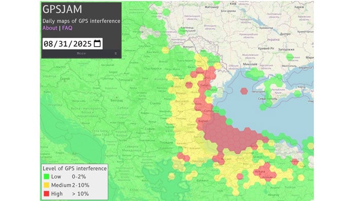
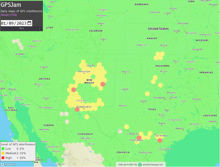
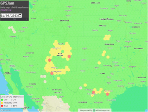
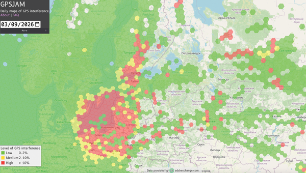
    As GPS World readers know, the growing prevalence of GPS/GNSS jamming and spoofing outside of conflict zones interrupts vital aviation safety technologies and presents challenges to maritime commerce and the global economy. An alarming example is playing out along the Baltic Sea and the North Sea, prompting 13 coastal European nations and Iceland to highlight in January 2026 “growing GNSS interference” and collectively reinforce requirements to comply with existing regulations and international law designed to ensure the safety of all maritime vessels engaged in shipping.

    As commercial aircraft report navigation anomalies and maritime operators experience false position data in congested waterways, global authorities are sounding alarms that GNSS interference will continue to rise without immediate action. In March 2025, the International Civil Aviation Organization (ICAO), International Telecommunication Union (ITU), and International Maritime Organization (IMO) issued a joint warning expressing “grave concern” that disruptions from GNSS jamming and spoofing constitute an urgent threat to public safety, telecommunications networks and international commerce.

    Compounding harmful interference incidents led the GPS Innovation Alliance (GPSIA) to act. Defeating illegal and harmful interference outside of combat zones requires a coordinated, whole-of-government strategy that focuses on stopping bad actors through deterrence and enforcement, and directing resources toward preventing and sanctioning those violating international commitments and laws prohibiting jamming and spoofing. Investing in GPS modernization and integrating innovative signals from complementary PNT satellite systems into devices and receivers will deliver PNT that surpasses today’s technologies to the global community.

    Roadmap for Action

    In September 2025, GPSIA led a coalition of leading industry groups in sending a letter to the Departments of Defense and Transportation that called for urgent action to address GPS jamming and spoofing. We noted the United States has the technology and expertise to solve this issue, and the administration has the power to act. GPSIA followed the letter with a whole-of-government strategy providing a clear roadmap for the administration. While some recommendations have been implemented, other opportunities remain. 

    Focus on the Real Culprits 

    The culprits in each of these scenarios are bad actors putting public safety and global commerce at risk with harmful interference outside conflict zones. The global community relies on several unique technologies that can be impacted by harmful interference, such as cellular and Wi-Fi signals, radars and automated information systems. The misplaced focus on faint GNSS signals or dependencies on GNSS derail collective efforts to immediately regain interference-free global commerce and bolster public safety. 

    Governments and international organizations mandate certain industries integrate safety-of-life technologies into their operations — and they do, at great cost. Officials should in turn be given the political support and resources to stop bad actors from
    intentionally interfering with them.

    What to Do Next 

    Public and continued diplomatic engagement are critical. By amplifying European counterparts, condemnations from senior U.S. officials can raise the reputational costs for bad actors and reaffirm international norms that protect GNSS signals and other technologies from harmful interference. 

    Engaging with the ICAO is important. The U.S. should reinforce its commitment to providing modern civil GPS signals that support navigation in international airspace and encourage ICAO to prioritize the enforcement of global GNSS protections. 

    GPSIA also recommends Executive agencies establish an interagency task force that rapidly identifies and disseminates information about interference events with civil operators, including sanitized intelligence information on intentional jamming and spoofing of commercial aircraft and ships.

    Civil operators also should be invited to participate in interference coordination calls and reporting. Sharing radio-frequency interference data, incident reports and threat assessments among military and civil agencies and operators is essential to preserving public safety. The Performance-based Operations Aviation Rulemaking Committee’s recommendations for continuity of operations during GPS disruption events should continue to be implemented with urgency.

    The GPS III satellite has additional anti-interference features. (Image: Lockheed Martin)
    The GPS III satellite has additional anti-interference features. (Image: Lockheed Martin)

    Deterrence and information sharing must be coupled with sustained enforcement. Federal agencies have taken welcome action to interdict illegal jamming equipment, reporting an 830% increase in seizures since 2021. We applaud the U.S. government for prioritizing resources to stop the illegal import and sale of these devices.

    GPSIA commends the Kingdom of Norway’s annual Jammertest, which allows receiver and device manufacturers to test interference detection and counter jamming and spoofing. These realistic test scenarios, together with strengthened enforcement and prioritized intelligence collection and analysis, will enhance public safety.

    Modernize GPS 

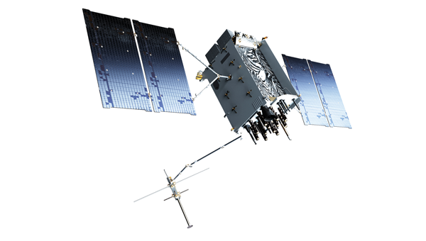
    While GPS satellites continue operating with an extraordinary 99.99% availability and no outages on record, the health of the constellation and jamming and spoofing incidents affecting receivers and devices, demand action. The final GPS III satellite is scheduled to launch this spring. Next-generation GPS IIIF satellites are being built. Their launches should be prioritized to reduce the number of satellites on orbit that are one system or subsystem away from failure. GPSIA welcomed the passage of the FY2026 Defense Appropriations Bill, which bolstered national and economic security by investing needed funding for modernized GPS IIIF satellites and long-term PNT leadership. 

    Notably, the current GPS program plan does not include counter-spoofing technologies. Implementing counter-spoofing authentication capabilities for Wide Area Augmentation System (WAAS) signals would further strengthen aviation resilience.

    Ground infrastructure modernization is equally important. The GPS ground station must be able to command and monitor GPS III and IIIF satellites and the modern L5 aviation signal.

    Streamline Regulatory Activities 

    Regulatory modernization represents another area of progress. In September 2025, the State Department removed jam-and spoof-resistant Controlled Reception Pattern Antennas (CRPAs) from the International Traffic in Arms Regulations (ITAR), fulfilling one recommendation from GPSIA’s strategy. 

    Certification processes also must evolve, and integration of CRPAs into aircraft should be accelerated. The modern L5 signal and counter spoofing signal authentication signals must be incorporated into FAA-certified and other receivers as soon as possible. 

    Recommendations for the FCC 

    President Trump’s December 2025 Executive Order (EO), “Ensuring American Space Superiority,” directs U.S. departments and agencies to detect and counter threats to U.S. space infrastructure. It also states that his administration will enable industry to develop and deploy advanced space capabilities, including terrestrial and cislunar PNT applications. This EO should serve as a “North Star” for the FCC, resulting in increased enforcement resources to address illegal jamming and spoofing, and a regulatory environment prioritizing innovative, advanced commercial satellite PNT systems that complement GPS. Demonstrating American leadership in space demands that we step forward, not backwards, in our PNT capabilities.

    The FCC is evaluating the record developed in its Notice of Inquiry, Promoting the Development of PNT Technologies and Solutions, and is reportedly considering future rulemaking. The FCC’s task is not to replace GPS, but to ensure that the regulatory environment protects its spectrum, increases enforcement actions against those perpetuating harmful interference and enables innovation that complements this foundational system. This balanced approach will fulfill President Trump’s mandate, preserving public safety and economic security, and ensure continued American leadership in PNT.

    Global Safety and Commerce 

    Baltic and North Sea shipping lanes have become a flashpoint for GPS jamming and spoofing, prompting 13 European nations and Iceland to issue a joint warning in January 2026 over interference threatening maritime safety and global commerce. (Photo: Dmitri Toms / iStock / Getty Images Plus / Getty Images)
    Baltic and North Sea shipping lanes have become a flashpoint for GPS jamming and spoofing, prompting 13 European nations and Iceland to issue a joint warning in January 2026 over interference threatening maritime safety and global commerce. (Photo: Dmitri Toms / iStock / Getty Images Plus / Getty Images)

    The FCC’s Notice of Inquiry uncovered dozens of PNT technologies, ranging from those in the marketing stage, to hyper-localized solutions, to proposals to exploit “signals of opportunity.” Creativity and ingenuity abound in the commission’s record, but the docket’s many filings lacked technical details to evaluate whether the systems advance the nation’s
    PNT leadership.

    The hallmarks of GPS are its worldwide coverage, and the continuity, availability, integrity and accuracy of its signals. Our modern global community deserves complementary PNT systems and signals that meet or exceed GPS capabilities. A few satellite-based solutions stood out as holding promise to do so. 

    Systems operating in low-Earth orbit (LEO) can transmit stronger signal power due to their proximity to Earth, improving performance in urban environments and contested spectrum conditions. Systems operating in different frequency bands, such as TrustPoint’s C-band system, add spectral diversity, making it far more difficult for an adversary to disrupt all PNT services simultaneously. When combined with modernized GPS signals and authentication capabilities, this layered approach can deliver robust services while complementing the foundational role of GPS.

    Terrestrial systems cannot replicate global coverage of satellite constellations. They are also vulnerable to wildfires, hurricanes and other disasters.Building parallel terrestrial networks would require significant investment while delivering a fraction of modernized satellite systems’ capabilities. Nor do terrestrial signals provide the continuity, availability, integrity and accuracy of satellite systems. 

    The Progress is Real

    GPSIA is pleased to report that progress is being made in several areas outlined in its “whole-of-government” strategy. It’s time to accelerate that progress. In May 2026, GPSIA members will convene to evaluate this strategy and outline what more the PNT industry can do to play a part in defeating harmful interference. Our members also will meet with government officials to underpin that government-led enforcement and solutions to jamming and spoofing can further illustrate the importance of PNT to U.S. leadership in space, and national security, public safety and the global economy. 

  • Plane carrying EU president hit by alleged Russian GPS jamming

    Plane carrying EU president hit by alleged Russian GPS jamming

    A plane carrying the European Commission President Ursula von der Leyen was targeted by GPS jamming while attempting to land at Plovdiv International Airport in Bulgaria on Aug. 31, according to a European Commission spokesperson.

    Bulgarian authorities suspect Russia was responsible for the interference, European Commission Deputy Chief Spokesperson Arianna Podestà told CNN.

    The Kremlin has denied the allegation. Spokesperson Dmitry Peskov told The Financial Times, which first reported the story, that the information was incorrect.

    The plane landed safely despite the GPS disruption, with pilots reportedly using paper maps to navigate, according to a source familiar with the situation.

    Von der Leyen was traveling as part of a seven-country tour of the European Union’s frontline states to rally support for Ukraine. The incident occurred as her charter flight approached the southern Bulgarian airport during her diplomatic mission to reinforce the bloc’s commitment to defending against Russian aggression.

    Podestà told CNN that the incident highlighted the urgency of von der Leyen’s current trip to frontline member states, where she has witnessed daily threats from Russia and its proxies. The spokesperson noted it remained unclear whether attackers specifically targeted the flight or if it was caught in broader GPS interference operations.

    Expert Insights: Searching for Resilience

    This latest incident comes amid a dramatic surge in GPS jamming and spoofing attacks across the region since Russia’s invasion of Ukraine, creating an increasingly challenging environment for critical navigation systems.

    European Commission President Ursula von der Leyen’s current tour through Poland, Bulgaria, Finland, Estonia, Lithuania, Latvia and Romania takes her directly through many of the continent’s GPS disruption hot spots. These nations have experienced some of the most severe interference with GNSS, making the timing of her defense-focused diplomatic mission particularly significant.

    According to GPS World Editorial Advisory Board Member Mitch Narins, the current crisis represents the culmination of concerns that have been raised for more than twenty years. “Concerns and warnings regarding interference to GNSS have been raised for over two decades,” Narins explains. “Despite these concerns, attempts to install and upgrade alternative or complementary PNT systems on the ground and in aircraft have failed and resulted solely in increased investment in satellites and their signals, all of which are extremely low-power by design and vulnerable to interference.”

    “Regrettably, the substantial financial resources required to fund these satellite projects have pushed for discontinuance of resilient ground-based alternatives and to consider them ‘cost offsets,’” he notes. The economic incentives have favored satellite constellation expansion over diversification, despite the vulnerabilities of space-based systems.

    When it comes to alternative options, Narins explains, “For the cost of building and launching a single GNSS medium-Earth orbit (MEO) satellite, one could fund the replacement or installation and operation of many resilient ground-based systems for many years.”

    The current approach to PNT systems represents a departure from fundamental systems engineering principles, according to Narins. “When initiating a customer need analysis, a systems engineer does not begin with the solution and work backwards,” he emphasizes.

    Instead, the focus should be on meeting actual requirements: PNT systems must “always” provide the accuracy, availability, integrity and continuity of services necessary to support safety, security and economic well-being across thousands of use cases spanning every critical infrastructure sector.

    “Therefore, resilience must be a critical part of a PNT system’s performance if it is to be considered a potential solution,” Narins said. Rather than pursuing interoperability between GNSS constellations — which still leaves users dependent on inherently weak satellite signals — the industry should have prioritized diverse solutions from the outset.

    He added, “This is not a simple problem with a single, simple solution, but it is time to start thinking about resilience first and leaving the identification of solutions to a proper system engineering process.”

    New Ways to Counter EW Threats

    The dangerous GPS jamming of the plane carrying carrying European Commission President Ursula von der Leyen can be alleviated with advanced technology, according to Michael Biercuk, CEO of Q-CTRL, developers of quantum-based navigation systems:

    “The incident regarding the European Commission President’s plane has raised GPS denial from inconvenience to a strategic security threat. This is why we’ve focused our quantum tech development efforts on building resilient quantum navigation systems truly immune to jamming and spoofing. This technology is not science fiction – it has been validated in flight to outperform the best existing GPS backups by up to 100X. Through our partnerships with Airbus, Lockheed Martin, and others we’re ready to help build resilience for European transport, defense and commerce.”

    Chris Shaw, CEO and co-founder of Advanced Navigation also spoke on the incident, commenting “The answers to the GPS crisis are already here,” said Chris Shaw, CEO and co-founder of Advanced Navigation, which specializes in anti-electronic warfare navigation technology. “The problem isn’t innovation, it’s stagnation. GPS alone can no longer be treated as a reliable source of truth. What’s needed is a resilient architecture — inertial-centered and fused with multiple sensors — that keeps systems operating even when signals are denied or manipulated.

    “The reality is that adversaries are moving at the speed of code, while government procurement still runs at the speed of bureaucracy. That gap is a national security risk. Unless governments adopt a new model of rapid integration and real-time collaboration with industry, they will continue to be outpaced.

    “This isn’t optional. Survivability in GPS-contested environments depends on prompt deployment of inertial navigation. The companies pushing this forward aren’t just keeping up, they’re rewriting the playbook — and the cost of delay is measured in mission failure and compromised sovereignty.

    “Ukraine has shown what’s possible. By demanding real-time software updates and rapid hardware upgrades in close collaboration with industry, its forces are reshaping autonomy, navigation, drone swarms and integrated defense systems at an unprecedented pace — allowing them to outpace adversaries.

    “So why aren’t we applying this model more broadly beyond the battlefield? The solutions exist, with inertial navigation at the core. The real question is whether we’ll act before the cost of delay becomes irreversible.”

    The GPS Collapse isn’t fiction — it’s a warning of what happens when action is delayed.

  • Russian electronic warfare base linked to GPS jamming across Baltic region

    Russian electronic warfare base linked to GPS jamming across Baltic region

    The Estonian news portal Delfi reports that a covert Russian military installation in the Królewiec region, just east of Poland’s border, is believed to be responsible for GPS interference affecting the Baltic states and the Gulf of Finland.

    According to confidential sources, the facility’s primary mission is to monitor satellites and NATO communications, with the goal of undermining allied intelligence operations. Documents obtained by Delfi indicate that the base, located in Pioniersk, is part of Russia’s “Tobol” electronic warfare network.

    The Tobol system is described as a network of surveillance, defense and command sites designed both to shield Russian satellite communications and navigation systems from NATO attacks and to disrupt NATO intelligence. The Królewiec facility, which focuses on satellite monitoring, was officially established in 2009 by the Russian Ministry of Defence. Similar installations are located across Russia, including near Moscow, Penza, Cheboksary and in Ulan-Ude, Siberia.

    In July, Estonian authorities detected new jamming equipment near the eastern border by Narva and along the Narew Gulf coast. Experts believe these measures are intended to protect Russian facilities from potential Ukrainian drone strikes.

    The Finnish newspaper Ilta-Sanomat, reports that Russia has been developing navigation jamming technology since the 1980s, initially as a counter to GPS-guided weapons. Those capabilities have since expanded in response to Western military equipment supplied to Ukraine.

    Since the start of Russia’s full-scale invasion of Ukraine in 2022, incidents of GPS interference have increased in countries bordering Russia. Aviation and maritime navigation have been particularly affected, with pilots and ship crews reporting inaccurate or lost positioning data.

  • Slingshot Aerospace advances GPS jamming detection for military intelligence and security

    Slingshot Aerospace advances GPS jamming detection for military intelligence and security

    The U.S. Space Force’s Space Systems Command (SSC) has awarded a $1.9 million contract to Slingshot Aerospace to enhance its GPS jamming and spoofing detection capabilities. This contract, Positioning, Navigation and Timing – Secure Electronic Navigation Threat Intelligence and Location (PNT-SENTINEL), aims to improve the company’s existing technology by incorporating advanced artificial intelligence and predictive analytics.

    The PNT-SENTINEL program builds upon Slingshot’s previous work under the Data Exploitation and Enhanced Processing (DEEP) contract, awarded in October 2021. The technology developed through DEEP currently assists the U.S. Space Force in detecting GPS jamming and ground-based interference sources related to ongoing conflicts, potential future conflict zones and counterterrorism efforts.

    GPS spoofing and jamming pose significant threats to both military operations and civilian infrastructure. Such interference can impact a wide range of operations, including satellite systems, ground and air operations and critical services such as commercial airline operations and vehicle navigation. The global reliance on GNSS has increased the importance of protecting these signals from interference.

    Slingshot’s technology utilizes a mesh network of thousands of satellites to create a near-real-time picture of GPS jamming occurrences worldwide. This space-based approach offers a more comprehensive view of global jamming conditions compared to traditional ground-based detection systems.

    As part of the contract, Slingshot will integrate its AI model, Agatha, into the PNT-SENTINEL system. This integration aims to enhance the technology’s ability to detect and differentiate between unintentional interference and deliberate jamming or spoofing attempts. The improved system will also implement pattern recognition algorithms to identify active jamming events and predict how situations may evolve.

    The contract also includes provisions for expanding the system’s capabilities to monitor interference across multiple GNSS sources, not just GPS. This multi-GNSS processing will allow for a more complete, real-time view of jamming activities by incorporating data from allied nations’ spacecraft.

    The PNT-SENTINEL system is designed to be interoperable with existing military systems, enabling near-real-time information dissemination to support rapid decision-making in national security operations. These enhancements aim to provide warfighters with a strategic advantage in GPS-contested environments.

  • Is Russia behind new GPS interference in Bulgaria?

    Is Russia behind new GPS interference in Bulgaria?

    On Dec. 12, 2024, the European Union decided to include Bulgaria and Romania in the Schengen visa-free zone. On the same day, Bulgaria’s capital, Sofia, began experiencing interference with GPS signals. The interference, as reflected in aviation ADS-B systems and reported on GPSJam.org, continued through the new year and is ongoing as of this writing. 

    While these two events may be entirely unrelated, Vladimir Putin has a history of using GPS jamming and spoofing to show his displeasure with his neighbors growing closer to the West.

    • On Dec. 15, 2023, Poland activated a U.S. Aegis anti-missile system near its border with Kaliningrad, Russia. On the same day, Russia began jamming and spoofing GPS signals in northern Poland and parts of the Baltic. That interference persists to this day.

    The interference in Sofia may be contributing to a prolonged Bulgarian political crisis. Politicians there have been struggling to form a new government since elections in October. Dec. 10 saw the beginning of a new attempt. Interference with GPS can undermine overall confidence in government systems and institutions — another of Putin’s goals for neighbors with whom he is displeased.

    Another, though less likely, impact may be on Bulgaria’s electrical service. On Dec. 25, 2024, 20,000 households in western Bulgaria (Sofia is in the far west) lost electrical power and the outage continued for days. Many grid operators use GPS timing to help manage their systems. While press reports put the outages down to heavy snow and fallen trees, increased difficulty managing the grid might also be a factor.

    Bulgaria’s GPS interference appears to be coming from somewhere in Sofia, not from Russian territory, as is the case in the Baltic. Yet Russia may still be involved, at least in a supporting role.

    On Dec. 11, the news outlet Balken Insight reported on five Bulgarians being tried by the United Kingdom as Russian spies. It also said the Bulgarian interim prime minister was being urged to investigate alleged links between the case and top officials in Sofia.

    GPS interference in Sofia, Bulgaria, began on dec. 12, 2024, and has continued at varying intensities. (Photo: GPSJam.org)
    GPS interference in Sofia, Bulgaria, began on Dec. 12, 2024, and has continued at varying intensities. (Photo: GPSJam.org)
  • Alleged North Korea GPS jamming disrupts flights and ships in South Korea

    Alleged North Korea GPS jamming disrupts flights and ships in South Korea

    South Korea’s military has reported that North Korea disrupted GPS signals from border areas for the fifth consecutive day, impacting numerous civilian flights and maritime vessels. This interference originated from the western border cities of Kaesong and Haeju, North Korea.

    According to NBC News, the GPS jamming affected the West Sea (Yellow Sea) area. While the exact number of affected flights and vessels was not specified, the disruption was significant enough to prompt warnings from South Korea’s Joint Chiefs of Staff (JCS) to aircraft and ships operating near the western border.

    “We urge North Korea to stop GPS interference provocations immediately and strongly warn that it will be held fully accountable for any resulting consequences,” South Korea’s joint chiefs said in a statement.

    The incident occurs amidst escalating tensions between North and South Korea. It follows recent provocations by North Korea, including test-firing of advanced solid-fuel ICBMs, launching balloons carrying waste and propaganda into South Korea and allegations of North Korean troops being deployed to support Russia in Ukraine.

    Aviation specialists have expressed concerns about the risks posed by these jamming activities, including potential dangers to commercial airlines flying in poor visibility, complications in airline operations, and violation of international conventions on navigational safety.

    The GPS jamming is seen as part of North Korea’s electronic and psychological warfare tactics, highlighting the vulnerability of South Korea’s critical infrastructure, notably the Incheon International Airport.

    Experts warn that jamming attacks can lead to serious incidents, including potential aircraft accidents in worst-case scenarios. The ongoing situation underscores the complex security challenges in the Korean peninsula and the broader implications for regional navigation stability.

  • UK Defense Minister’s plane jammed near Russia

    UK Defense Minister’s plane jammed near Russia

    Image: Phillip Silverman / iStock / Getty Images Plus / Getty Images / Getty Images
    Image: Phillip Silverman / iStock / Getty Images Plus / Getty Images / Getty Images

    A plane carrying British Defense Secretary Grant Shapps had its satellite signal jammed as it flew near Russian territory, the government reported on March 14.

    The government said that the Royal Air Force jet carrying Shapps, officials and journalists “temporarily experienced GPS jamming when they flew close to Kaliningrad” on a flight from Poland to the UK.

    The Times of London, whose reporter was onboard, said that for about 30 minutes mobile phones could not connect to the internet and the aircraft was forced to use alternative methods to determine its location.

    Kaliningrad is a Russian enclave bordered by Poland and Lithuania, home to the Russian Navy’s Baltic Fleet. Prime Minister Rishi Sunak’s spokesman, Dave Pares, said “the jamming didn’t threaten the safety of the aircraft at any point.” He added that it is not unusual for aircraft to experience electronic jamming near Kaliningrad.

  • Beyond the frontlines: The far-reaching effects of electronic warfare

    Beyond the frontlines: The far-reaching effects of electronic warfare

    Image: guvendemir/ E+/Getty Images
    Image: guvendemir/ E+/Getty Images

    Electronic warfare in the Middle East and Ukraine is affecting air travel far beyond the battlefields, unnerving pilots and revealing unintended consequences of a tactic that experts believe will become more widespread, reported The New York Times 

    Planes are losing satellite signals, flights have been diverted and pilots have received false location reports or inaccurate warnings that they were flying close to terrain, according to European Union safety regulators and an internal airline memo viewed by The New York Times. The Federal Aviation Administration (FAA) has also warned pilots about GPS jamming in the Middle East. 

    Following Russia’s invasion of Ukraine in early 2022, radio frequency interference only continues to increase across the Middle East as of autumn 2023. These interferences can involve jamming GNSS signals to obstruct or block them using noise, or mimicking signals to trick GNSS receivers into picking up counterfeit satellite signals, known as spoofing.  

    Aircraft systems have been unable to detect GPS spoofing and ultimately correct for it. According to Opsgroup, an organization that monitors changes and risks in the aviation industry, one Embraer jet bound for Dubai nearly veered into Iranian airspace in September before the pilots figured out the plane was chasing a false signal. 

    “We only realized there was an issue because the autopilot started turning to the left and right, so it was obvious that something was wrong,” crew members reported to Opsgroup. 

    Issues arise 

    With the rise of electronic warfare, the strain on aviation could be a sign of more serious economic and security issues.  

    The U.S. government calls GNSS signals “an invisible utility.” Smartphones, cars, stock exchanges, data centers and countless industries rely on them for time, navigation or both. Similar systems exist around the world, such as Galileo in Europe, Glonass in Russia, QZSS in Japan, NavIC in India and BeiDou in China. One study from Britain said a five-day disruption of satellite signals could cost the country $6.3 billion. 

    Minor interference with GPS signals is fairly common. GPS jamming devices, while illegal to use, are inexpensive and easy to obtain from vendors on the internet. Governments, too, have been more willing to overtly interfere with signals as a tactic in electronic warfare. 

    It is not always possible to distinguish jamming from spoofing, or to determine who is behind the interference. Israel said in mid-October it had restricted GPS in the region and had warned pilots not to rely on satellite navigation systems for landing.  

    Russian interference is well-documented. A 2019 report by the Washington-based analytical nonprofit group C4ADS showed extensive spoofing from a Russian-controlled air base in Syria. Reports also indicated that, when Russian President, Vladimir Putin, traveled to remote locations or Russian-occupied Crimea, he was flanked by mobile GPS-spoofing technology. 

    Russia has disrupted GPS signals to misdirect Ukrainian UAVs and throw precision-guided shells off their targets. Ukraine also jams Russian receivers but lacks the same level of sophistication 

    Jamming is common in conflict zones. Spoofing, until recently, was considered rare.   

    The interference has been felt up to 190 miles away from battlefields and “appears to go well beyond simple military mission effectiveness,” according to Eurocontrol, Europe’s primary air-traffic-control manager. The worst-affected regions include the aerial space above the Black Sea area from Turkey to Azerbaijan; the Mediterranean Sea extending from Cyprus to Libya; the Baltic Sea near Poland and Latvia; and the Arctic near Finland and Norway. 

    Airbus said it recorded nearly 50,000 interference events on its aircraft last year, more than four times as many as the year before. This came on top of an over twentyfold jump in radio-interference events from 2017 to 2018, as recorded by a voluntary incident reporting system run by Eurocontrol. Eurocontrol said the increased jamming since 2018 was most likely meant to interfere with battlefield UAVs. 

    In the Middle East, there have been reports of false signals telling pilots their aircraft were directly above the airport in Tel Aviv despite being far away. Opsgroup said it had received around 50 similar reports. In some cases, onboard equipment showed that planes were approaching airports in Baghdad, Cairo or Beirut, Lebanon, when they were not. 

    Looking ahead 

    Spoofing is hard to distinguish because the signal appears legitimate. Only Europe’s Galileo incorporates an authentication system that can verify when a signal is from its satellites. Galileo, which currently is the most accurate and precise navigation satellite system, plans to introduce an even stronger level of authentication, according to the European Commission. 

    But even Galileo’s authentication cannot protect against one of the most dreaded types of spoofing, known as “meaconing.” In a meaconing attack, a spoofer would record satellite signals, and then rebroadcast them with an amplification or a delay. Experts have not publicly confirmed any meaconing attacks in the Middle East. 

    Opsgroup said the latest events should prompt manufacturers to re-examine the integration of satellite signals in aircraft electronics, known as avionics, without a safeguard that can identify false signals.

    In this environment of intentional GPS jamming and spoofing, Israel has produced a leading anti-jam technology company, InfiniDome, located in Caesarea. According to co-founder Omer Sharar, the company has been working to defend GPS signals for more than seven years and has also seen the rise of devices to jam the GPS L1 frequency that anyone can buy online for $100.   

    Gpsdome-1 (left) protects GPS L1. GPSdome-2 (right) protects GPS L1/L2 or GPS L1/GLONASS L1.
    Gpsdome-1 (left) protects GPS L1. GPSdome-2 (right) protects GPS L1/L2 or GPS L1/GLONASS L1. (Image: InfiniDome)

    Most readily available jammer electronics only output interference disrupting GPS L1, which is commonly installed for vehicle tracking and UAV guidance. InfiniDome says it has successfully protected trucking, UAV operations and others in Israel and around the world with its Infinidome GPSdome-1 and GPSdome-2 anti-jam products. 

    It is clear the conflict’s repercussions extend well beyond the battlefield, highlighting the critical need for security assessments or alternative PNT systems to protect civilians. While there is going to be a significant impact on commercial airline travel to and from Israel while hostilities continue, there is hope for a possible long-term solution for the intense jamming that has plagued the region for years.  

  • Seen & heard: BeiDou birds and spoofing target airlines

    Seen & heard: BeiDou birds and spoofing target airlines

    “Seen & Heard” is a monthly feature of GPS World magazine, traveling the world to capture interesting and unusual news stories involving the GNSS/PNT industry.


    galitskaya/iStock/Getty Images Plus/Getty Images
    Image: galitskaya/iStock/Getty Images Plus/Getty Images

    The scooter burglar

    By using location data and a username from a Lime rental scooter, police have identified a man caught on video scootering around a Denver, Colorado, neighborhood loading up on stolen goods from surrounding homes, reported 9 News. Police obtained a search warrant for the scooter’s location data and account information. The suspect appears to have used his real name when renting the scooter to conduct the burglaries. 9 News is not naming the man identified as the scooter user as he hasn’t been arrested or charged. However, a background check on his name revealed he’s currently wanted on two theft cases that occurred in 2022, also in Denver.


    Doordashing goes wrong

    Image: ProjectB/E+/Getty Images
    Image: ProjectB/E+/Getty Images

    A DoorDash driver followed his navigation system into a wooded area and then into a body of water while attempting to deliver an order to a residential neighborhood in Middleton, Massachusetts, reported the Daily Caller. After following the navigation system straight into water, the driver called police. The Middleton Police Department is now charging the DoorDash driver for “negligent operation of a motor vehicle” and has put in a request to suspend the driver’s license.


    BeiDou birds

    Image: Paola Iamunno/iStock/Getty Images Plus/Getty Images
    Image: Paola Iamunno/iStock/Getty Images Plus/Getty Images

    Researchers at the Jiangxi Nanfengmian National Nature Reserve in China are utilizing BeiDou during bird banding to monitor their migration period from September to October. Bird banding involves attaching customized tags to birds’ legs or wings to track their movements and patterns. Out of 614 birds, 36 are being equipped with specially designed positioning devices that will continuously transmit data for researchers to analyze migration routes, stopping places, and migration time, according to a nature reserve official.


    Spoofing targets airlines

    Image: Chalabala/iStock/Getty Images Plus/Getty Images
    Image: Chalabala/iStock/Getty Images Plus/Getty Images

    More than 20 airline and corporate jets flying over Iran overnight on October 1, were targeted by spoofed GPS signals. The spoofed signals were sent from the ground, infiltrated the navigation systems of the jets, and steered them off course, reported The Times of India. According to the Ops Group, which runs a flight data intelligence crowdsourcing website, a majority of the GPS spoofing occurred in airway UM688 in Iran’s airspace. In response, the U.S. Federal Aviation Administration issued this warning to airlines: “Iraq/Azerbaijan — GPS jamming and spoofing poses safety risk.”

  • NTS-3 satellite to launch this year

    NTS-3 satellite to launch this year

    The Navigation Technology Satellite–3 (NTS-3) — designed, built and tested by L3Harris — is on track to launch this year. The experimental satellite aims to shape the future of U.S. positioning, navigation and timing capabilities and to help U.S. forces to operate in GPS-denied environments and areas prone to spoofing.

    NTS-3 minimizes the impacts of GPS jamming through rapidly reprogrammable signal waveforms, frequency agility and increased signal strength. Its embedded software and firmware are reprogrammable on-orbit.

    When paired with reprogrammable receivers, the U.S. Air Force and U.S. Space Force can react in real time as threats evolve on the battlefield. In addition, NTS-3 has enhanced processors to support more complex signals.

    In January, L3Harris delivered the NTS-3 vehicle to Kirtland Air Force Base, New Mexico, to prepare the satellite for launch. The Air Force Research Laboratory and L3Harris are working together to complete space vehicle testing, launch vehicle integration and enterprise integration to confirm compatibility between the control segment, ground receivers and the satellite vehicle.

    NTS-3 is scheduled to launch later this year aboard United Launch Alliance’s Vulcan Centaur rocket. Once launched, NTS-3 will remain in a near-geosynchronous orbit for an inaugural year of testing.

  • Australian aircraft’s GPS receiver jammed allegedly by Chinese warships

    Australian aircraft’s GPS receiver jammed allegedly by Chinese warships

    Image: JIWEI QU/iStock/Getty Images Plus/Getty Images
    Image: JIWEI QU/iStock/Getty Images Plus/Getty Images

    Some airlines and military aircraft, including the Australian commercial airline Qantas, are receiving radio interference and GPS jamming from alleged Chinese warships in the Asia Pacific, report Australia Aviation and The Guardian.

    The International Federation of Air Line Pilots’ Associations (IFALPA) released a statement acknowledging the reports of interference and recommended that pilots carry on, not respond to the warships and report all incidents to air traffic control.

    “IFALPA has been made aware of some airlines and military aircraft being called over 121.50 or 123.45 by military warships in the Pacific region, notably South China Sea, Philippine Sea, East of Indian Ocean. In some cases, the flights were provided vectors to avoid the airspace over the warship. We have reason to believe there may be interferences to GNSS and RADALT as well,” the statement noted.

    Further recommendations from IFALPA include notifying company dispatchers of the attempted contact and completing an ASAP report or other company safety report for non-ATC communication or GNSS interference.

  • One GPS Mystery Solved, Another Remains

    One GPS Mystery Solved, Another Remains

    Ever since it came on-line in February 2022, the website GPSJam.org has shown what appears to be regular interference with GPS signals in Texas near San Antonio and Del Rio, and locations north and south of Oklahoma City, Oklahoma.

    Only on normal workdays, however. Not on weekends or holidays. Furthermore, whatever was happening also took time off between the Christmas and New Year holidays GPSJam.org also shows similar, though less regular, activity in New Mexico. Experts say this is easily explained as White Sands Missile Range is often the site of electronic warfare training and tests. These are always announced in advance in FAA Notices to Air Missions (NOTAMs) when any interference with GPS reception is anticipated.

    The regular patterns observed in Texas and Oklahoma and the lack of NOTAMs led some experts to speculate the source could be inadvertent interference from a commercial or government activity. Said one former official, “It’s just the kind of pattern you see from large organizations. They are off every weekend, federal holidays, and around Christmas.”

    Aerobatic-capable Military Training aircraft reporting low NIC values (Image: Stanford University)
    Aerobatic-capable Military Training aircraft reporting low NIC values (Image: Stanford University)

    GPSJam.org is the brainchild of aviation analyst John Wiseman. The site uses crowdsourced ADS-B reports gathered by the ADS-B Exchange and displays it on a world map. Areas in yellow indicate that between two and ten percent of ADS-B reports for the day had low navigation accuracy. Areas in red had ten percent or more.

    Information from the site has proved useful in identifying patterns of regular GPS jamming and spoofing in Russia and other conflict areas around the globe.
    The workday patterns in Texas and Oklahoma have appeared on GPSJam.org displays since the site went live in February 2022.

    GPS Interference and Aviation

    Minor interference with GPS signals is fairly common. GPS jamming devices, while illegal to use, are inexpensive and easy to obtain from vendors on the internet.

    Truck drivers wanting to defeat their company’s fleet tracking system, people concerned about being tracked by the government or others, even ministers trying to keep parishioners from texting during sermons – all have been known to use such devices.

    Most GPS interference is unintentional. A two-year European Union study found hundreds of thousands of potentially harmful signals, but judged only about ten percent to be intentional. The rest were the inadvertent byproduct of poorly tuned electrical and electronic equipment.

    ADS-B tracks of training aircraft performing aerobatics. Red indicates low NIC value reported. (Image: Stanford University)
    ADS-B tracks of training aircraft performing aerobatics. Red indicates low NIC value reported. (Image: Stanford University)

    While most GPS interference is unintentional and localized, spurious signals powerful enough to noticeably impact airborne operations are not unknown.

    In two separate incidents last year strong interference near the Denver and Dallas airports impacted air traffic, each for more than a day. The Denver incident lasted for 33 hours before authorities found the source and shut it down. Air traffic was disrupted at Dallas for 44 hours according to government sources, though researchers found the actual interference only lasted for 24 hours. The source of the disruption was never identified.

    In 2019 a passenger aircraft was almost lost due to GPS interference while on approach to Sun Valley, Idaho’s Friedman Memorial Airport. As the aircraft flew a GPS-based approach in smoke and haze, the interfering signal was just strong enough to lure it off course and toward a mountain. Fortunately, a sharp-eyed radar controller hundreds of miles away spotted the problem and intervened in time. The source of the interference was never identified.

    As a result of the Sun Valley incident and input from numerous aviation groups, the International Civil Aviation Organization told its members there was an “urgent need to address harmful interferences” to satnav signals.

    Texas and Oklahoma Mystery Solved

    A researcher at Stanford University finally solved the puzzle of the strange recurring sequence of reports from Texas and Oklahoma.

    While investigating last October’s GPS interference event near the Dallas airport, PhD candidate Zixi Liu noticed aircraft outside the main area of effect also reporting low Navigation Integrity Category (NIC) values. This began before and continued after complaints from commercial airlines about GPS not being available at Dallas-Fort Worth. These aircraft were in the same general area of Texas, but far enough away that there were large areas between them and Dallas that did not contain any reports with low NIC values.

    Low navigation accuracy reports displayed at GPSJam.org. in New Mexico reports were due to GPS interference from military testing. In Texas and Oklahoma, military aerobatics training likely caused reports of low navigation accuracy. (Image: GPSJam.org)
    Low navigation accuracy reports displayed at GPSJam.org. in New Mexico reports were due to GPS interference from military testing. In Texas and Oklahoma, military aerobatics training likely caused reports of low navigation accuracy. (Image: GPSJam.org)

    At the same time MS Liu was also investigating anomalous ADS-B reports near San Antonio and Del Rio, Texas. She discovered in all three cases the reports of low NIC values were coming from military training aircraft regularly used for aerobatics. Other aircraft nearby reported good NIC values and showed no evidence interference.

    In a recent presentation to the Institute of Navigation, she postulated that Interference with GPS signals was not the cause of the low navigation integrity reports. Rather, the rapid maneuvers and unusual aircraft attitudes of aerobatics caused the airplanes’ navigation receivers to intermittently lose lock on signals from GPS satellites. This caused their ADS-B equipment to report low navigation integrity.

    Having solved that mystery, Ms. Liu continues to work on her original question – identifying the source of October’s 24-hour GPS disruption near the Dallas-Fort Worth airport.

    Mr. Dana A. Goward is the President of the Resilient Navigation and Timing Foundation and a former US Coast Guard helicopter pilot.