The Lockheed Martin team developing the U.S. Air Force’s next-generation Global Positioning System III satellites has turned on power to the system module of the program’s first spacecraft, designated GPS III Space Vehicle One (SV-1). The milestone is a key indication the team is on track to deliver the first satellite for launch availability in 2014, the company said.
The GPS III program will replace aging GPS satellites, while improving capability to meet the evolving demands of military, commercial and civilian users. GPS III satellites will deliver better accuracy and improved anti-jamming power while enhancing the spacecraft’s design life and adding a new civil signal designed to be interoperable with international global navigation satellite systems.
“This milestone is the latest in a series of critical events signifying that our joint government and industry GPS III team is performing efficiently and meeting its commitments,” said Lt. Col. Todd Caldwell, the U.S. Air Force’s GPS III program manager.
Successfully powering on GPS III SV-1 demonstrates mechanical integration, validates the satellite’s interfaces and leads the way for electrical and integrated hardware-software testing. The satellite will complete its Assembly, Integration and Test (AI&T) in Lockheed Martin’s new GPS Processing Facility (GPF) designed for efficient and affordable satellite production. Like in aircraft or automobile manufacturing, each GPS III satellite will move through sequential work stations for various AI&T operations, culminating with shipment to the launch site.
“Turning power on to the first GPS III satellite is a major milestone for the team,” said Keoki Jackson, vice president of Lockheed Martin’s Navigation Systems mission area. “The successful integration of the first satellite’s system module follows on the heels of our pathfinder GPS III Non-Flight Satellite Testbed (GNST), and demonstrates the great value of the investments made by the Air Force to implement low-risk spacecraft acquisition. In this challenging budget environment, we are focused on delivering the critical GPS III capabilities to users affordably and on schedule.”
The GPS III team is led by the Global Positioning Systems Directorate at the U.S. Air Force Space and Missile Systems Center. Lockheed Martin is the GPS III prime contractor with teammates ITT Exelis, General Dynamics, Infinity Systems Engineering, Honeywell, ATK and other subcontractors. Air Force Space Command’s 2nd Space Operations Squadron (2SOPS), based at Schriever Air Force Base, Colo., manages and operates the GPS constellation for both civil and military users.
New Organization Advocates for GPS Industry; Galileo Lives to Fly Another Day, Budget Passed; Safer Skies for EGNOS; and GLONASS in Brazil
New Organization Advocates for GPS Industry
A new group, the GPS Innovation Alliance, has formed and announced itself as the voice of the U.S. GPS industry and community of users, to “support the ever-increasing importance of GPS” in the U.S. capital, Washington, D.C. The organization subsumes and replaces both the U.S. GPS Industry Council, an entity of longstanding, and the Coalition to Save Our GPS, which arose in March 2011 in response to a Federal Communications Commission (FCC) conditional waiver granted to LightSquared.
The alliance appears to reflect a desire on the part of some industry members to take a more aggressive approach inside the Washington Beltway, a sign, it would seem, of the political times. Some of those involved spoke informally of a desire to take advantage of contacts made on Capitol Hill and in the media during the highly visible LightSquared combat, fought in the glare of media attention heretofore unknown in industry circles.
GPSv Innovation Alliance logo
Members of the Alliance are drawn from a variety of fields and businesses reliant on GPS, as well as leading manufacturers of GPS equipment. The former group includes, aviation, agriculture, construction, transportation, first responders, and surveying and mapping, and consumer organizations representing users of GPS for boating and other outdoor activities, and in automobiles, smartphones, and tablets.
Joining John Deere, Garmin, and Trimble — three lead drivers of the Coalition effort at the FCC — are NovAtel Inc. and Topcon Positioning Systems. All five were previously long-time members of the USGIC, and they appear as founding members of the alliance at www.gpsalliance.org.
Affiliate members listed on the website include the Association of Equipment Manufacturers, General Aviation Manufacturers Association, National Association of Manufacturers, Association for Unmanned Aerial Vehicles International, and Boat Owners Association of the United States.
The alliance plans to build on “the proud heritage and extensive expertise of the United States GPS Industry Council (USGIC), which was formed in 1991 to promote broader commercial applications of GPS and to expand global markets while assisting in safeguarding the technology’s military advantages. The council has a long history of highly effective advocacy on behalf of the GPS industry, as well as serving as a trusted source of objective information for policy makers, the media and the public both in the U.S. and around the world.” The alliance website gives a longer statement about the history and record of the USGIC, highlighting its role in international negotiations.
Michael Swiek, executive director of the USGIC, has transitioned to become the executive director, executive branch and international, of the Innovation Alliance. In addition to working closely with leading offices of executive branch departments of the U.S. government, he will continue well-established dialogs with governmental, private sector and academic entities in areas critical to GPS and satellite navigation among key players in Europe, Japan, Russia, Korea, China, and elsewhere.
Heather Hennessey, a principal of Innovative Federal Strategies LLC, a “comprehensive government relations firm,” has taken the position of executive director, legislative, at the alliance. Hennessey has seven years of service in the House of Representatives, including two years as chief of staff for Congressman Jack Kingston of Georgia.
An active voice in alliance representations on Capitol Hill will presumably be that of Jim Kirkland, vice president and general counsel for Trimble. Kirkland was the most prominent spokesperson for the coalition during the LightSquared battle, which appears to be either over or nearly so. “The alliance is committed to ensuring constructive, robust dialog between GPS users, manufacturers and policy makers on critical policy issues affecting GPS,” Kirkland said, “a commitment Trimble is pleased to be a part of as the industry continues to innovate and modernize.”
The alliance mission statement cites the importance of GPS to global economy and infrastructure; vows to aid further GPS innovation, creativity and entrepreneurship; and to protect, promote and enhance the use of GPS.
The GPS Innovation Alliance officially launched on February 13 with a reception on Capitol Hill, a traditional lobbying tactic that previous efforts had perhaps not envisioned. The organization has also hired a public relations firm, Prism Public Affairs, and commissioned a logo.
Galileo Lives to Fly Another Day, Budget Passed
European Union leaders approved a scaled-down budget in early February, with none of the cuts to the Galileo program that had been widely feared. The project, conducted by the European Space Agency (ESA) under close supervision of the European Commission (EC), will draw on funding of 6.3 billion euros (about $8.5 billion) from 2014 to 2020. The satellite navigation program held onto its requested revised budget of 6.3 billion euros, even as telecommunications research and broadband deployment projects, including another ESA pet project, the somewhat related Copernicus Global Monitoring for Environment and Security (GMES), underwent severe cuts. Galileo has already spent more than 3 billion euros ($4 billion), three times its original budget, to launch four of an envisioned 30-satellite constellation.
The EU deliberative system requires unanimous approval of budget decisions, so what smaller countries seek for their farmers or fishermen carries practically equal weight to the desire of industrial/aerospace giants like Germany, closely followed by France and the United Kingdom. Negotiation is a delicate matter indeed, and reached an impasse in November 2012; resolution came only after a 24-hour marathon session of talks. The total budget represents the first decrease in the European Union’s history; austerity is the watchword in a region beset with an ongoing bevy of international debt crises and serious recession in many of the smaller EU countries.
Galileo supporters within the European Commission, the EU’s policy-making arm, continued to maintain that Galileo will “open a whole new world” for business to develop applications, as Antonio Tajani, EC vice president stated recently. The program drew strong support, for once, from powerful backers in the EU administrative capital, Brussels, and among industrial and political interests in key member states: France, Germany, and for an exception Britain, often a proponent of deep cuts.
Negotiators helped Galileo’s chances by placing it in a research group labeled “Competitiveness for Growth and Jobs.” This category actually rose in budget allocation by nearly 40 percent over the last seven-year allotment.
The allocation should cover operational costs for EGNOS and Galileo, the completion of the initial Galileo constellation of 14, and early procurement stages of a full, or second-generation orbiting set of 30.
The program still faces an extremely unlikely date for the establishment of early services by the end of 2014. “Then, the market, as well as the governments of the Member States, will start increasing their interest and promoting further investments,” the ever-optimistic Tajani maintained.
The budget must still secure approval by the European Parliament. Its president, Martin Schulz of Germany has stated, “The further we step away from the Commission’s proposed figures, the more likely the proposal will be rejected. More and more tasks, and less and less money — the inevitable result is budget deficits. The Parliament will not go along with this.”
Parliament’s decision is forecast for the summer months. Parliament’s budget power consists of a direct yes-or-no vote to accept or reject the budget. The body cannot make modifications, and if rejecting would simply send it back to the EU ministers to begin all over again. The picture is further complicated somewhat by the 20-nation make-up of ESA, whereas the European Union and its executive commission have 27 national members.
Safer Skies for EGNOS
Results of a September 2012 flight test in the Galileo Test and Development Environment (GATE) near Berchtesgaden, Germany, the one place on Earth where Galileo services are already routinely available, show that adding Galileo signals to the European Geostationary Navigation Overlay Service (EGNOS) should boost accuracy significantly. EGNOS augments the accuracy and reliability of GPS signals over Europe, rendering satnav usable for safety-critical applications such as aircraft guidance, as well as more general precision uses.
Operational horizontal and vertical distance “protection levels” for safety were cut by half by combining use of GPS and Galileo within EGNOS. In addition, new integrity algorithms installed within the user receiver turned out to reliably detect and exclude reflected or otherwise faulty signals.
Next-generation EGNOS, planned for 2020, is envisaged to augment both constellations and dual frequencies at the same time, making the system much more robust.
GLONASS in Brazil
The first overseas GLONASS ground monitoring station for differential correction and monitoring outside Russian territory opened in Brasilia, Brazil, in mid-February. The station represents an early step in an initiative to modernize and significantly improve the accuracy of GLONASS signals.
Plans call for similar monitoring stations “in more than 30 countries of the world. Most of the countries that received the offers for the installation of the stations responded positively.However, the process is slow because of the need to conclude appropriate intergovernmental agreements. The documents with Brazil were signed in 2012. Agreements with Spain, Indonesia and Australia will be finalized soon,” according to a Pravda story.
The Lockheed Martin team developing the U.S. Air Force’s next generation Global Position System III satellites has completed a key flight software milestone validating the software’s ability to provide reliable and effective command and control for the GPS III satellites planned for launch into orbit.
The GPS III program will affordably replace aging GPS satellites, while improving capability to meet the evolving demands of military, commercial and civilian users. GPS III satellites will deliver better accuracy and improved anti-jamming power while enhancing the spacecraft’s design life and adding a new civil signal designed to be interoperable with international global navigation satellite systems.
The milestone, known as Software Item Qualification Testing (SIQT), was completed for the satellite’s spacecraft bus flight software, which is critical to controlling the spacecraft on orbit and monitoring the health and safety of the satellite’s subsystems. SIQT included 131 individual test events and represented the culmination of a rigorous software engineering risk reduction and development phase. The software will next be integrated and tested on the first GPS III satellite, which is on schedule for launch availability in 2014.
“Completion of this flight software milestone demonstrates our continued positive program momentum and is another step forward in reducing risk up front to facilitate long term affordability,” said Lt. Col. William ‘Todd’ Caldwell, the U.S. Air Force’s GPS III program manager. “In this challenging budget environment, the entire government and industry team is focused on delivering the critical GPS III satellites affordably and efficiently for users worldwide.”
To further reduce risk, the flight software has already been integrated and tested on the program’s satellite prototype, known as the GPS III Non-Flight Satellite Testbed (GNST).
“Delivering fully qualified flight software this early in program development demonstrates the rigor of our GPS III software development processes,” said Keoki Jackson, vice president of Lockheed Martin’s Navigation Systems mission area. “Through up-front investments in high-fidelity, flight equivalent hardware and software testbeds, our team successfully executed on schedule to develop and qualify the flight software critical to the success of the GPS III program.”
Lockheed Martin is on contract to deliver the first four GPS III satellites for launch. The Air Force plans to purchase up to 32 GPS III satellites.
The GPS III team is led by the Global Positioning Systems Directorate at the U.S. Air Force Space and Missile Systems Center. Lockheed Martin is the GPS III prime contractor with teammates ITT Exelis, General Dynamics, Infinity Systems Engineering, Honeywell, ATK and other subcontractors. Air Force Space Command’s 2nd Space Operations Squadron (2SOPS), based at Schriever Air Force Base, Colorado, manages and operates the GPS constellation for both civil and military users.
ITT Exelis has been awarded a $2.15 million contract by the Air Force Research Laboratory (AFRL) to research the development of a small satellite navigation payload to augment the current GPS program. The GPS NAVSAT (Navigation Satellite) program seeks to provide affordable capabilities to aid end-users located in tough-to-reach environments.
“The development of smaller satellites — in terms of size, weight, power and cost — will yield greater affordability for our customers,” said Mark Pisani, vice president and general manager, Precision Instruments and Positioning, Navigation and Timing Systems, ITT Exelis Geospatial Systems. “A smaller satellite size will allow for improved launch vehicle selection flexibility.”
The goal of the 18-month initial study is to identify innovative ways to increase affordability and sustainment of the GPS program through payload weight reduction, size and power. The GPS NAVSAT will maintain similar performance capability to the existing GPS system, but will aid GPS end-users in signal-constrained environments, located in urban or mountainous terrain.
Work on GPS NAVSAT is performed in Clifton and Bloomfield, New Jersey.
For nearly 40 years, Exelis payloads and payload components have been on board every GPS satellite with more than 500 years of on-orbit life without a single mission-related failure due to Exelis equipment.
The Delta 4 rocket’s cryogenic upper stage engine experienced a fuel leak that caused a low-thrust condition. Four-and-a-half minutes into the launch, after the first stage had shut down and separated, the trouble began as the RL10B-2 engine on the upper stage extended its nozzle and fired to life.
When the powerplant was igniting and reached its peak chamber pressure, a leak started above the narrow throat portion of the thrust chamber, setting off a chain of nail-biting events over the next three hours as the vehicle made its climb to the GPS constellation. The Delta 4 made autonomous adjustments, however. The onboard inertial guidance and flight control systems compensated for the lower thrust conditions. Its closed loop guidance system measured the decreased thrust in real time and revised the trajectory and burn durations to ensure the mission succeeded. The GPS IIF-3 satellite was delivered to the correct orbit as planned.
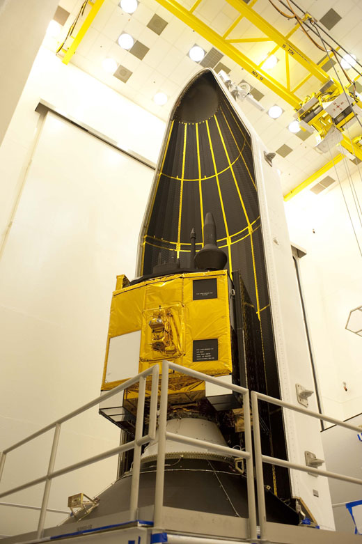
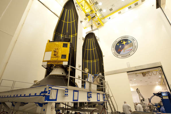
The Lockheed Martin team developing the U.S. Air Force’s next generation Global Positioning System III satellites has completed thermal vacuum testing for the Navigation Payload Element (NPE) of the GPS III Non-Flight Satellite Testbed (GNST). The milestone is one of several environmental tests verifying the navigation payload’s quality of workmanship and increased performance compared to the current generation of satellites, the company said.
The GPS III program will affordably replace aging GPS satellites, while improving capability to meet the evolving demands of military, commercial and civilian users. GPS III satellites are expected to deliver better accuracy and improved anti-jamming power while enhancing the spacecraft’s design life and adding a new civil signal designed to be interoperable with international global navigation satellite systems.
“GPS III satellites have the most advanced navigation payloads ever manufactured. This milestone is a key indicator that we have a solid design and are on track to provide unprecedented position, navigation, and timing capability for GPS users worldwide,” said Lt. Col. Todd Caldwell, the U.S. Air Force’s GPS III program manager.
During thermal vacuum testing, the navigation payload’s performance was proven in a vacuum environment at the extreme hot and cold temperatures it will experience on orbit to ensure it will operate as planned once in space. Following the test, the NPE will now be integrated with the GNST for final satellite level testing.
The GNST is a full-sized prototype of a GPS III satellite used to identify and solve development issues prior to integration and test of the first space vehicle. The approach significantly reduces risk, improves production predictability, increases mission assurance and lowers overall program costs. Following integration and test at Lockheed Martin’s GPS Processing Facility (GPF) near Denver, the GNST will be shipped to Cape Canaveral Air Force Station, Fla., for risk reduction activities at the launch site.
“The completion of thermal vacuum testing on our first navigation payload is a critical milestone for our program that demonstrates we are on a solid path to meet our commitments,” said Keoki Jackson, vice president of Lockheed Martin’s Navigation Systems mission area. “The Air Force’s early investment in our GPS III pathfinder is now paying off and will enable highly efficient and affordable satellite production going forward.”
Lockheed Martin is on contract to deliver the first four GPS III satellites for launch. The Air Force plans to purchase up to 32 GPS III satellites.
The GPS III team is led by the Global Positioning Systems Directorate at the U.S. Air Force Space and Missile Systems Center. Lockheed Martin is the GPS III prime contractor with teammates ITT Exelis, General Dynamics, Infinity Systems Engineering, Honeywell, ATK and other subcontractors. Air Force Space Command’s 2nd Space Operations Squadron (2SOPS), based at Schriever Air Force Base, Colo., manages and operates the GPS constellation for both civil and military users.
UPDATE: The SVN65/PRN24 L5 transmitter has now been switched on. L5 is the civilian safety-of-life GPS signal, designed to meet demanding requirements for safety-of-life transportation and other high-performance applications.
UPDATE: The GPS Block IIF-3 satellite, SVN65, began transmitting L1 and L2 signals as PRN24 on October 8. A number of stations of the International GNSS Service are now tracking the satellite. The satellite is included in broadcast almanacs although it is set unhealthy and will continue to be so until satellite commissioning is completed. The satellite is still drifting towards its designated orbital position of Slot 1 in Plane A.
Meanwhile, SVN27/PRN27 was decommissioned from active service on October 6 and removed from the broadcast almanacs. However, the L-band
transmitters of SVN27 remain active, presumably for end-of-life testing.
UPDATE: According to Boeing, the satellite manufacturer, SVN65 is on orbit and performing as expected. A Boeing press release stated that “Controllers confirmed initial contact with the spacecraft at 11:43 a.m. Eastern time. The satellite’s GPS signals will be turned on and tested within a few days.”
Incidentally, the launch occurred exactly 55 years to the day after the launch of the world’s first satellite, Sputnik I, on October 4, 1957. It was Doppler tracking of that satellite that gave rise to the Transit navigation system and subsequently, its successor, GPS.
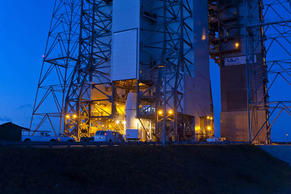
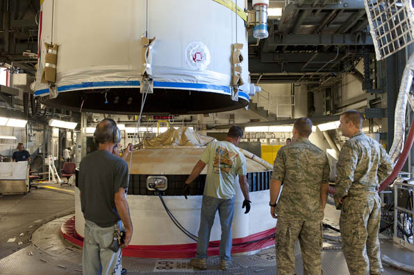
The launch of the GPS Block IIF-3 satellite took place as scheduled October 4 at 12:10 UTC (8:10 a.m. EDT), aboard a United Launch Alliance Delta IV rocket from Cape Canaveral, Florida. Spacecraft separation was reported at 16:27 UTC.
The Boeing-built spacecraft is designed to improve network coverage for both civilian and military networks, including a new L5 signal for improved commercial and civil aviation users.
The satellite, also known as SVN65, will be positioned in orbital slot 1, which is in plane A and will use the PRN24 ranging codes. Slot 1 was recently occupied by a Block IIA satellite, SVN39, operating as PRN09. SVN39 is one of the oldest operating satellites in the GPS fleet, having been launched on 26 June 1993. SVN39 underwent an initital Delta-V on September 27 to move it close to SVN38/PRN08 in slot 3 in plane A, making room for the new Block IIF satellite.
“Congratulations to the entire team on today’s successful launch of the GPS 2F-3 satellite,” Jim Sponnick, ULA vice president, Mission Operations, said in a post-launch press release.
“ULA and our mission partners have a rich heritage with the GPS program and we are proud to have served alongside the government and contractor teams over the last two decades to provide important Global Positioning System capabilities for our national defense and for millions of civilian and commercial users around the world.”
A Delta IV rocket lifts-off with an advanced GPS satellite from Cape Canaveral on Thursday. (Credit: ULA/Atkeison).
2. GPS SATELLITE SVN65 (PRN24) WAS LAUNCHED ON JDAY 278.
A USABINIT NANU WILL BE SENT WHEN THE SATELLITE IS SET ACTIVE TO
SERVICE.
3. POC: CIVILIAN – NAVCEN AT 703-313-5900, HTTP://WWW.NAVCEN.USCG.GOV
MILITARY – GPS OPERATIONS CENTER AT HTTPS://gps.afspc.af.mil/
GPSOC , DSN 560-2541,
COMM 719-567-2541, [email protected] , HTTP://gps.afspc.af.mil/GPSOC/GPS
MILITARY ALTERNATE – JOINT SPACE OPERATIONS CENTER, DSN 276-3514.
COMM 805-606-3514. [email protected]
Lift-off is set for 8:10 a.m. EDT (1210 GMT) Thursday for a GPS IIF satellite, reports Spaceflight Now. GPS IIF-3 will replace an aging 19-year-old craft in plane A, slot 1, part of the program to incrementally upgrade the GPS constellation with greater accuracy, better jam-resistance, and a new civilian aviation signal, all of which are features of the Boeing-build Block IIF series.
The United Launch Alliance Delta 4 rocket and GPS satellite payload will undergo a final technical assessment today and a readiness review Tuesday before entering into countdown operations Wednesday night.
The 19-minute launch window is timed to deliver the GPS IIF-3 satellite directly into plane A of the navigation network 11,000 miles above Earth.
The satellite is expected to be checked out and ready for handover to Air Force controllers by mid-November, according to Jan Heide, Boeing’s GPS program director.
Raytheon Company and Lockheed Martin have successfully completed the first launch readiness exercise for the U.S. Air Force’s next generation GPS III satellites. The exercise is a key milestone demonstrating the team remains on schedule to achieve launch availability in 2014, the companies said.
The Lockheed Martin-built GPS III satellites and the Raytheon-developed next generation GPS operational control system, known as OCX, are critical elements of the U.S. Air Force’s effort to affordably replace aging GPS satellites while improving capability to meet the evolving demands of military, commercial and civilian users worldwide. This is the first space and ground enterprise successfully building the ground control and space vehicles by two independent prime contractors.
The launch readiness exercise, completed over a three day period by mission operations personnel, validated the basic satellite command and control functions, tested the software and hardware interfaces and demonstrated basic on-console procedures required for space vehicle contacts during the launch and early orbit mission. The event sets the stage for the first GPS III satellite’s mission readiness timeline, which includes five short-duration exercises and six, five-day mission rehearsals leading up tolaunch.
“Completion of our first GPS III launch readiness exercise is a major milestone for the entire GPS enterprise and is a solid indictor that our space and ground segments are well synchronized,” said Col Bernie Gruber, the director of the U.S. Air Force’s Global Positioning Systems Directorate.
To achieve first launch availability in the 2014 timeframe, the U.S. Air Force awarded Lockheed Martin and Raytheon contracts in January of this year to provide a Launch and Checkout Capability (LCC) for launch and early on-orbit testing of all GPS III satellites. At the heart of the LCC is Raytheon’s Launch and Checkout System that will provide satellite command and control capability, an integral part of OCX’s support of the first GPS III launch.
“The completion of our first launch readiness exercise is an important milestone for the entire GPS enterprise,” said Keoki Jackson, vice president of Lockheed Martin’s Navigation Systems mission area. “This achievement is a testament to efficient planning and synchronization by the U.S. Air Force and demonstrates that we are on track to deliver critical GPS III capabilities to military, commercial and civilian users worldwide.”
“This milestone represents the hard work and dedication of the entire GPS III and OCX government-industry team,” stated Ray Kolibaba, a vice president of Raytheon’s Intelligence and Information Systems business and GPS OCX program manager. “This is another demonstration of the rapid progress we’re making on OCX development, while maintaining GPS space-ground enterprise alignment. I’m confident that we’ll be prepared to support the first GPS III launch with an efficient, evolvable and secure ground control system built independently.”
The GPS III team is led by the Global Positioning Systems Directorate at the U.S. Air Force Space and Missile Systems Center. Air Force Space Command, based at Schriever Air Force Base, Colo., manages and operates the GPS constellation for both civil and military users.
Spaceflight Now is reporting that the next GPS satellite, Block IIF-3 (SVN65) to be launched on October 4, 2012, will be positioned in orbital slot 1, which is in plane A. This slot is currently occupied by a Block IIA satellite, SVN39, operating as PRN09. SVN39 is one of the oldest operating satellites in the GPS fleet, having been launched on June 26, 1993.
This will be the third satellite in the Block IIF series of GPS spacecraft with improved accuracy, enhanced internal atomic clocks, better anti-jam resistance, a civil signal for commercial aviation (and others) and a longer design life. Boeing is building a dozen craft to upgrade the constellation’s foundation over the coming years.
The GPS Block IIR-M satellite, SVN49, resumed transmissions as PRN24 at about 18:35 UTC on August 9, 2012. The signals are marked unhealthy and the satellite is not included in broadcast almanacs. SVN49 was launched on March 24, 2009, but remains out of service until an L1/L2 satellite multipath issue is resolved.
By Brady O’Hanlon, Mark L. Psiaki, Paul M. Kintner Jr., and Steven P. Powell
Anomalous behavior of the L1 C/A-code carrier phase has been detected on PRN07/SVN-48. The anomalies are sudden step-like changes of phase by about 10 degrees/5 millimeters. These steps are followed by negative steps of the same magnitude that restore the original phase time history. These anomalous square pulses have been observed with durations as short as 0.1 seconds and as long as 600 seconds. They can occur about once a minute or be absent for hours.
These anomalies could be of consequence for some GNSS applications. For precise monitoring of differential total electron content (TEC), the magnitude of this anomaly is the same order as the signals of interest. Precise point positioning (PPP) systems seek to achieve CDGPS accuracy without direct double-differencing. The lack of double-differencing would allow any L1 C/A carrier phase anomaly to directly affect the PPP solution.
This behavior was detected when testing a dual-frequency software receiver that processes the GPS civilian signals on L1 and L2. The anomaly was first noted when calculating carrier-phase-based TEC:
where bTEC is a bias term that occurs in the phase-based calculation. Figure 1 shows a plot of the resulting TEC, after removal of its mean value, with six square-edged pulses that range in duration from 0.1 to 590 seconds, with the first a short one at t = 48 seconds. The last pulse starts at 710 seconds and ends at 1300 seconds. In all cases, the anomaly consists of a positive step change in TEC followed some time later by a negative step change of identical magnitude. Step magnitudes in the range 0.04 to 0.07 TEC units have been observed.
Figure 1. Square pulses on phase-based TEC due to L1 C/A carrier phase anomalies.
Tests were performed to ascertain whether the anomalies were caused by the L1 signal, the L2 signal, or a combination of the two. Additional tests ruled out receiver malfunction as the cause of the anomalies.
Observation of detrended L1 and L2 carrier-phase time histories quickly revealed that the anomalies occur on the L1 carrier phase. The detrended L1 C/A carrier phase shows square-edged pulses corresponding to times, magnitudes, and signs of the TEC anomalies, but the detrended L2C carrier-phase plots show no such pulses. Figure 2 shows a typical detrended L1 C/A beat carrier-phase anomaly.
Figure 2. A typical detrended L1 C/A beat carrier-phase anomaly.
Extensive tests checked whether the anomalies may have been caused by the receiver. They were initially discovered using a digital storage receiver of raw RF front-end samples followed by off-line software receiver processing. Such carrier-phase anomalies could result from signal glitches in the RF front-end’s mixing chain, from data recording anomalies in the RF front-end samples, or from errors in the software receiver code. The former two possibilities were ruled out by two means. One was to process signals from other satellites for the same RF samples. Mixing problems or data sample problems would cause similar anomalies on all GPS signals, but other GPS signals were found to be free of anomalies. Additional tests used simultaneous data collection by two digital storage receivers spaced 700 meters apart and using different RF front-end hardware. Both receivers showed identical anomalies at identical times.
Software receiver code errors were ruled out by employing two independent sets of receiver processing code, one developed in MATLAB, the other in C. These two pieces of software were developed independently by different individuals and run independently by their developers. Both showed identical anomalies.
A final check used a different receiver, the NovAtel GSV4004B. Figure 2 plots its detrended L1 C/A carrier phase along with that of the C-based Cornell software receiver. Both show the same anomaly. Thus, the anomalies appear to be caused by the SVN-48 transmitter.
All observations were made from roof-mounted antennas in Ithaca, New York. The anomalies were first observed on March 24, 2010 and were observed again on April 1, 5, 7, and 29, and as late as May 13th. For one period of several hours on May 11, no anomalies occurred. Other Block IIR-M satellites have been monitored briefly, but without finding any similar anomalies to date: SVNs 58, 55, 57, 49, and 50.