Raytheon Company reached several milestones recently in its development of the GPS Next -Generation Operational Control System (GPS OCX). Lockheed Martin’s GPS III Non-flight Satellite Testbed (GNST) — a full-sized, functional satellite prototype currently residing at Cape Canaveral Air Force Station — successfully established remote connectivity and communicated with OCX during pre-flight tests.
GNST proved that it could connect with and receive commands from Raytheon’s Launch and Check Out System (LCS), a part of OCX that supports the satellite and mitigates risks prior to launch. The GNST received commands from Lockheed Martin’s Launch and Checkout Capability (LCC) node in Newtown, Pennsylvania via the OCX servers at Raytheon’s facility in Aurora, Colorado; the system then returned satellite telemetry to the control station. The tests mirror launch and early orbit testing planned for all flight vehicles.
“While we have connected OCX with ground-based simulators before, these tests were the first time that OCX and a GPS III satellite have actually communicated,” said Keoki Jackson, vice president for Lockheed Martin’s Navigation Systems mission area.
Ahead of Schedule. Raytheon received Interim Authorization to Test (IATT) security certification from the U.S. Air Force for OCX LCS four months ahead of schedule. The company received a one-year certification with no liens, meaning the government does not require any changes.
“Typically, IATT certification is given for six-month increments,” said Matthew Gilligan, Raytheon’s GPS OCX program manager and a vice president in Raytheon’s Intelligence, Information, and Services business. “The LCS one-year accreditation speaks to the quality of the information assurance design and threat protection.” The IATT not only includes the LCS, but also Lockheed Martin’s GPS III satellite support systems, Exercise and Rehearsal Training Tool, and Upload Generation Tool.
OCX is being developed in two blocks. There are seven iterations in Block 1 and one in Block 2. LCS is the fifth Iteration of Block 1; it successfully completed Critical Design Review in June 2013.
Early Orbit Exercises. Lockheed Martin and Raytheon also completed the third of five planned launch and early orbit exercises to demonstrate launch readiness of GPS III and OCX.
Exercise 3 demonstrated space-ground communications; first acquisition and transfer orbit sequences; orbit-raising maneuver planning and execution; and basic anomaly detection and resolution capabilities. In addition, the industry and Air Force GPS Directorate teams jointly executed mission planning activities, such as orbit determination and the generation of upload command files.
Two additional readiness exercises and six 24/7 launch rehearsals are planned before launch of the first GPS III satellite. The first flight GPS III space vehicle (SV-01) is expected to be available for launch in 2014, and launched by the U.S. Air Force in 2015.
Exelis Encryptors. Exelis delivered the first three of a planned 14 ground-based encryptors to Raytheon Company for OCX. Designed to automatically code and decode GPS signals, encryptors facilitate the exchange of user information by securely transmitting navigation payload data between the OCX ground station and the orbiting constellation of satellites.
Delivery followed successful thermal, electromagnetic interference and security verification testing. Exelis provides critical elements of software in the navigation processing subsystem that will enable controllers to better understand the exact position of GPS satellites. This helps ensure accurate navigation information is securely broadcast to users. In addition to encryptors, Exelis is building high-precision receivers for use in GPS ground monitoring stations and satellite signal simulators for testing purposes.
Exelis is also on contract with Lockheed Martin to provide the payloads for the GPS III satellites.
During the August test, the GPS III Non-flight Satellite Testbed (GNST) proved that it could connect with and receive commands from the Launch and Check Out System.
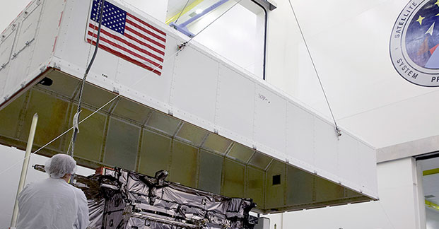
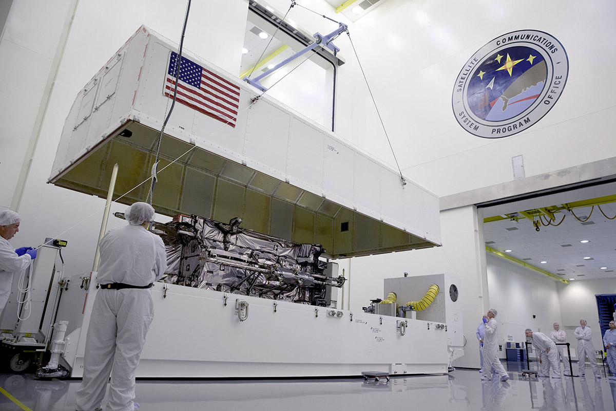
The prototype for Lockheed Martin ‘s next generation GPS III satellite reached a major milestone on August 30 when it successfully established remote connectivity and communicated with the GPS Next Generation Operational Control System (OCX), being developed by Raytheon, during a series of pre-flight tests.
During the Compatibility and Integration (C&I) Tests, Lockheed Martin’s GPS III Non-flight Satellite Testbed (GNST) — a full-sized, functional satellite prototype currently residing at Cape Canaveral Air Force Station — proved that it could connect with and receive commands from Raytheon’s Launch and Check Out System (LCS), part of the next-generation OCX that supports the satellite and mitigates risks prior to launch.
The GNST received commands from the LCC node at Lockheed Martin’s facility in Newtown, Pennsylvania, via the OCX servers at Raytheon’s facility in Aurora, CO, the system then returned satellite telemetry to the control station. The tests mirror launch and early orbit testing planned for all flight vehicles.
“The GNST is essentially a non-flying, functional GPS III satellite. While we have connected OCX with ground-based simulators before, these C&I tests were the first time that OCX and a GPS III satellite have actually communicated,” explained Keoki Jackson, vice president for Lockheed Martin’s Navigation Systems mission area.
Matthew Gilligan, a vice president with Raytheon’s Intelligence, Information and Services business and Raytheon’s GPS OCX program manager, stated, “This was an invaluable early opportunity to demonstrate command and control of the GPS III satellite with LCS, proving the end-to-end system capabilities well before putting an actual GPS III in orbit. The positive results tell us that we are right on track for the first GPS III launch.”
The LCS works hand-in-hand with Lockheed Martin’s Launch and Checkout Capability (LCC) contract, which brings online some of OCX’s GPS III-specific capabilities early to provide on-orbit checkout and control of the satellites.
The GNST has been at the Cape since July dry-running launch base space vehicle processing activities and pre-launch testing that all future flight GPS III satellites will undergo. The first flight GPS III space vehicle (SV-01) is expected to be available for launch in 2014, and launched by the U.S. Air Force in 2015.
Prior to shipment to the Cape, the GNST was developed and then completed a series of high-fidelity activities to reduce program risks, improve efficiencies and pathfind the integration, test and environmental checkout that all production GPS III satellites undergo at Lockheed Martin’s new GPS III Processing Facility in Denver, Colo.
An innovative investment by the Air Force under the original GPS III development contract, the GNST has helped to identify and resolve development issues prior to integration and test of SV-01. Following the Air Force’s rigorous “Back-to-Basics” acquisition approach, the GNST has gone through the development, test and production process for the GPS III program first, significantly reducing risk for the flight vehicles, improving production predictability, increasing mission assurance and lowering overall program costs.
The Lockheed Martin-developed GPS III satellites and Raytheon’s OCX are critical elements of the U.S. Air Force’s effort to modernize the GPS enterprise more affordably while improving capabilities to meet the evolving demands of military, commercial and civilian users worldwide.
GPS III satellites will deliver three times better accuracy; provide up to eight times more powerful anti-jamming capabilities; and include enhancements which extend spacecraft life 25 percent further than the prior GPS block. The GPS III also will carry a new civil signal designed to be interoperable with other international global navigation satellite systems, enhancing civilian user connectivity. The spacecraft bus and antenna assemblies for the first GPS III satellite have been delivered to Lockheed Martin’s GPS III Processing Facility and are in the integration and test flow leading to the planned space vehicle delivery in 2014.
Lockheed Martin is currently under contract for production of the first four GPS III satellites (SV 01-04), and has received advanced procurement funding for long-lead components for the fifth, sixth, seventh and eighth satellites (SV 05-08).
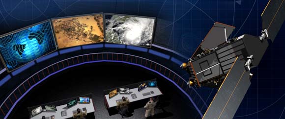
OCX will revolutionize GPS command and control and mission management capabilities, controlling all legacy and new military and civil signals, providing protection against evolving cyber threats and ensuring continuity of operations during cyber attacks, and reducing operation and sustainment costs through efficient software architecture, automation and performance-based logistics. OCX represents a quantum leap in capabilities over the current Operational Control System and provides flexibility and adaptability to meet future GPS mission needs. Raytheon is the OCX prime contractor and is on track to deliver the final Launch and Checkout System in 2014.
The GPS III team is led by the Global Positioning Systems Directorate at the U.S. Air Force Space and Missile Systems Center. Lockheed Martin is the GPS III prime contractor with teammates ITT Exelis, General Dynamics, Infinity Systems Engineering, Honeywell, ATK and other subcontractors. Raytheon is the GPS OCX prime contractor with teammates ITT Exelis, Boeing, Braxton, Infinity Systems Engineering, and NASA’s Jet Propulsion Laboratory. Air Force Space Command’s 2nd Space Operations Squadron (2SOPS), based at Schriever Air Force Base, Colo., manages and operates the GPS constellation for both civil and military users.
Designed to automatically code and decode GPS signals, encryptors facilitate the exchange of user information by securely transmitting navigation payload data between the OCX ground station and the orbiting constellation of satellites.
“Following successful thermal, electromagnetic interference and security verification testing, Exelis delivered the first three of 14 encryptors,” said Kevin Farrell, positioning, navigation and timing general manager for Exelis Geospatial Systems. “Once integrated into the OCX system, the encryptors will help ensure that the next generation of GPS satellites will be ready for launch and provide advanced capabilities and security to both military and civilian users of the signal and the overall GPS modernization effort.”
Exelis provides critical elements of software in the navigation processing subsystem that will enable controllers to better understand the exact position of GPS satellites. This helps ensure accurate navigation information is securely broadcast to users. In addition to encryptors, Exelis is building high-precision receivers for use in GPS ground monitoring stations and satellite signal simulators for testing purposes.
As part of the overall GPS modernization effort, Exelis is also on contract with Lockheed Martin to provide payloads for GPS III satellites. Exelis is a major space technology provider, supporting both the satellite and ground portions of the GPS III modernization program.
For nearly 40 years, Exelis payloads and payload components have been on board every GPS satellite and have accumulated more than 500 years of on-orbit life without a single mission-related failure due to Exelis equipment.
Raytheon Company has received Interim Authorization to Test (IATT) security certification for the Global Positioning System Next Generation Operational Control System (GPS OCX) Launch and Checkout System (LCS) four months ahead of schedule.
Raytheon received a one-year certification with no liens, meaning the government does not require any changes. The LCS IATT certification enables Raytheon to move to the next stage of testing the Launch and Checkout System in preparation for launch of the first GPS III satellite.
“Successful IATT certification ahead of our original schedule demonstrates not only that Raytheon meets the U.S. Air Force’s high standards for information assurance as we develop this critical national system, but also the efficient efforts of our government partners,” said Matthew Gilligan, Raytheon’s GPS OCX program manager and a vice president in Raytheon’s Intelligence, Information and Services business. “Typically IATT certification is given for six-month increments; the LCS one-year accreditation speaks to the quality of the information assurance design and threat protection.”
The Interim Authorization to Test not only includes the LCS, but also Lockheed Martin’s GPS III satellite support systems, including the Exercise and Rehearsal Training Tool and Upload Generation Tool.
The next-generation GPS ground-control system, known as OCX.
Raytheon’s OCX and the Lockheed Martin-built GPS III satellites are critical elements of the U.S. Air Force’s effort to modernize the GPS enterprise while improving capabilities to meet the evolving demands of military, commercial and civilian users worldwide. OCX is being developed in two “blocks” using a commercial best-practice iterative software development process. There are seven iterations in Block 1 and one in Block 2. LCS is the fifth Iteration of Block 1, and it successfully completed Critical Design Review in June 2013.
The first GPS III satellite is in production at Lockheed Martin and expected to be delivered to the U.S. Air Force “flight-ready” in mid-2014. GPS III satellites are expected to deliver three times better accuracy, provide up to eight times more powerful anti-jamming capabilities, and include enhancements that extend spacecraft life 25 percent further than the prior GPS block. The GPS III also will carry a new civil signal designed to be interoperable with other international global navigation satellite systems, enhancing civilian user connectivity.
A March 2013 report from the Government Accountability Office (GAO) seems to claim that the projected cost of the next-generation GPS ground-control system, known as OCX, increased by 43 percent, or $1 billion over the past year, to a total cost estimate of $3.7 billion. As GPS World contributing editor Don Jewell wrote shortly after the GAO release, “In fact, the report does not actually say that exactly, but you have to dig deep to determine that. Most readers won’t take the time to do that and will assume that the OCX program is grossly over budget. It is not.” A Raytheon spokesperson pointed out that the basis for the program cost estimate goes far beyond the scope of the original 2010 Raytheon prime contract of $886.4 million, and that the current value of the company’s contract is $969 million.
Design requirements for OCX call for it to support the GPS III constellation’s stringent accuracy, anti-jam, and information assurance requirements. The system is also to be backward-compatible with current GPS satellites. The original contracted carried an initial delivery date of 2016. At least some of the government-specified revisions in the contract come in the context of the need for absolute information assurance, given the Internet- and associated computer program-hacking by foreign sources, considered alongside the vast user base supplied by GPS, including the U.S. military’s reliance on its capability for many functions.
Kevin Ramundo, Vice President for Communications, Raytheon Intelligence, Information and Services, commented:
“GPS modernization through the launch of GPS III satellites and the GPS OCX ground system will provide new mission-critical capabilities to war fighters and additional capacity to meet the needs of millions of additional GPS users each year.
“Since the initial contract award, Raytheon’s GPS OCX program has made considerable progress including Milestone B approval and the successful completion of two ground station/satellite integration exercises. Nearly 50 percent of the software development is complete.
“With regard to the GAO report, it is important to note that the basis for their program cost estimate goes far beyond the scope of the Raytheon contract. In 2010, the contract award to Raytheon for GPS OCX was $886 million. The current value of our contract is $969 million, which now includes additional scope such as launch and check-out capability, tech baseline, and special studies.”
In December 2012, Col. Bernie Gruber of the U.S. Air Force GPS Directorate wrote in the pages of GPS World what was the commonly accepted perception of and public government position on OCX:
“Along with a host of additional satellite capabilities and signals, we will correspondingly modernize our ground segment. Our Next-Generation Operational Control System (OCX) is designed to command and control our modernized secondary civil signal L2C, safety-of-life signal L5, and the internationally compatible signal L1C. . . . . . As the modernized signals become operational, users will see faster signal acquisition, enhanced reliability, and a greater operating range. The information assurance, expandability, and service-oriented architecture will afford users and operators with security and information they simply don’t have today.”
The View from 2013. The 190-page GAO report, “Defense Acquisitions: Assessments of Selected Weapon Programs,” states that the scope and complexity of key OCX program elements was underestimated, and alluded to overruns that have historically beset Pentagon space programs.
specifically address OCX, which is identified as one of 19 weapons “Programs That Entered Development with Technologies Fully Mature or Nearing Maturity” and one of 14 “Programs with technologies nearing maturity at knowledge point 1 date.” OCX is given a knowledge point 1 date of November 2012.
According to the Report, “Air Force officials recently stated that, although GPS III is still maintaining an April 2014 “available for launch” date for the first satellite, the planned launch date is being moved to May 2015 in order to synchronize it with the availability of the GPS Operational Control Segment (OCX) Block 0, without which the satellites cannot be launched and checked out.”
“The program has experienced significant requirements instability and schedule delays while in technology development,” the report reads. “The contractor initially underestimated the scope and complexity of the necessary information assurance requirements which required additional personnel with the necessary expertise and increased government management.”
Changes in Specifications. In June 2012, a Raytheon executive stated that the OCX contract had been significantly modified, with the addition of a launch and checkout capability that had previously been the responsibility of Boeing, prime contractor on the GPS IIF satellites.
He also identified information assurance, a primary OCX requirement, as “a big challenge. It is very important that we protect this system against the current and evolving cyber threats because they are real and the nation can’t afford to have this system compromised.”
An Update Last Autumn. In a November 2012 conversation with GPS World defense editor Don Jewell, Raytheon VP and Program Manager for OCX Ray Kolibaba made the following remarks:
“We currently have 450 people at Raytheon working OCX, and with our subs, an additional 300 personnel. Altogether we have 750 personnel working GPS and OCX issues. This does not include the military and civilian personnel at Air Force Space Command and Space and Missile Systems Center.”
[ . . . . ]
Headshot: Ray Kolibaba
“Basically we are nearly on cost for the OCX contract. The current contract value is $925M; the original cost estimate was $886M. We are driving forward on that and the Block 1 date or Ready to Operate (RTO) date. Right now, the customer team is working on finalizing a new enterprise schedule that will show the Program Management Directive dates. So, we don’t know the exact date the government envisions. I expect an official date either late this year or early next year. I encourage you to ask Colonel Gruber [U.S. Air Force GPS Directorate] this question, and maybe then we will also get an answer. We have given them our recommendations.
“Concerning sequestration, I am not worried. I believe we have a reasonable level of support from Congress to maintain and continue OCX. That doesn’t mean something won’t change. Our Washington folks tell us that OCX appears to be on solid footing. The Air Force FY13 Research, Development, Test & Evaluation budget request for OCX, to include Raytheon, support contractors, the GPS Directorate, Federally Funded Research and Development Centers and the like, was $371.6M, and the Continuing Resolution amount was $369.4M — given the current budget environment, that is strong Congressional support.”
[ . . . . . ]
“Successful completion of OCX will make a huge difference on a number of fronts. For instance, even though the FAA and DOT don’t have a whole lot of funding to ante up, we are going to make a difference in how they operate in the future. Some actions are transparent, but not all, as we implement their requirements and as we move forward with OCX.
“The sooner we implement the true capabilities of GPS on airliners and stop adhering only to the fixed air routes, the sooner we will start saving time and money with a vastly more efficient and flexible air routing system.
“So, from the civil side, there is certainly a difference, and when we bring other signals in they will be key for us, such as L2C, L5, and L1C. We have the solutions to do that with our receivers at this point in time, and I think it is fairly low-risk. Indeed that is probably another of my unofficial milestones.
“[On] the navigation side, GPS accuracy will noticeably improve, and we will use a new Kalman Filter. We are working the new Kalman filter with ITT Exelis and JPL to enhance capabilities. Couple that with better information assurance, increased integrity and predictability, along with system safety, and you have many of the key differences in the OCS system going forward.
[ . . . . . . ]
“We are required to support 40 PRNs at a minimum, with growth potential to 63 PRNs, and we may be able to support more. I’m not sure there is a limit on the system as such.”
“Most readers [of the report] won’t take the time to [dig deep] and will assume that the OCX program is grossly over budget. It is not. In fact, to reach that extraordinary number, OCX cost overruns would need to have grown by 43 percent for each year since it was awarded, and that is ludicrous. According to Raytheon VP and OCX Program Manager Ray Kolibaba, the $3.695 billion number probably comes from including “…programmatic costs beyond OCX development costs and pessimistic projections from the government” that in my experience no acquisition agency, nor Congress for that matter, would ever include when determining true program cost adherence parameters.
Jewell makes the further point that OCX has grown in scope and schedule due in part to government change requests, mainly in the cyber and information assurance areas.
Where It Stands Now. Notwithstanding the optimism of the Raytheon OCX program manager six months ago, it is reasonable to expect that the GAO estimate of increased cost has drawn Congressional attention, and that in the current fiscal climate, the entire program may once again be imperiled.
The Japanese government has ordered three navigation satellites from Mitsubishi Electric Corp. to expand the Quasi-Zenith Satellite System (QZSS), reports Spaceflight Now. QZSS augments GPS navigation signals for users in the Asia-Pacific region.
NEC Corporation has also been awarded a contract, for the Ground Control Segment.
Japan’s Cabinet Office announced the QZSS expansion on March 29, approving a $526 million contract with Mitsubishi Electric for the construction of three satellites for launch before the end of 2017. Two of the spacecraft will be placed in inclined orbits, and one satellite will operate in geostationary orbit over the equator.
Michibiki, the website version.
NEC Corp. will operate QZSS for 15 years under a $1.2 billion contract that covers the design, verification and maintenance of the QZSS ground system.
A ground system aimed at enhancing the navigation precision of China’s homegrown BeiDou Navigation Satellite System (BDS) was approved in central China’s Hubei Province on Friday, according to NZWeek.
The BeiDou Ground Base Enhancement System (BGBES) is a network consisting of 30 ground base stations, an operating system and a precision positioning system. It was approved by the evaluation committee led by Sun Jiadong, an academician with the Chinese Academy of Sciences (CAS) and chief designer of the BDS.
The system is expected to improve the BDS’ positioning precision to 2 centimeters horizontally and 5 centimeters vertically via tri-band real-time precision positioning technology, and to 1.5 meters with the single-frequency differential navigation technology.
Ray Kolibaba, Raytheon VP and Program Manager for OCX, took part in a candid conversation with Don Jewell, our defense editor at GPS World. Kolibaba gives us an unprecedented look at the GPS ground control segment, warts and all, as it exists today. His updates about a viable program are good news because at one time the OCX program was close to being terminated. Join us now for a look at OCX today and the way ahead for the GPS ground control segment.
By Don Jewell
Ray Kolibaba, Raytheon vice president and program manager for OCX.
DJ: Ray, thanks for taking time to be with us today. Perhaps we should start off with your title, your bona fides if you will, and just what you do at Raytheon in Aurora, Colorado.
RK: Don, I am a vice president at Raytheon here in Aurora and the GPS OCX program manager.
DJ: Concentrating on the OCX program, how many people do you oversee and how many people do you have on your team including sub-contractors? In other words, just how big an effort is OCX when it comes to manpower?
RK: We currently have 450 people at Raytheon working OCX, and with our subs, an additional 300 personnel. Altogether we have 750 personnel working GPS and OCX issues. This does not include the military and civilian personnel at AFSPC and SMC. [ed. Air Force Space Command and Space and Missile Systems Center].
DJ: It sounds like a thousand people when you account for all the different players. An important part of the Raytheon team has to be your subcontractors. Let’s talk about your subs and the roles they play, just so our readers have an idea of the expertise required for OCX to succeed.
RK: Don, our subs are a critical part of our team and we could not succeed without them. First of all, our major subcontractors on board include ITT Exelis — their primary role is navigation, along with JPL [ed. Jet Propulsion Laboratory]. JPL is active in the Kalman Filter area. Key management and global monitoring station receivers are also part of Exelis’ efforts. They are based in New Jersey and have been a key part of this team from the beginning. I am happy to say they survived the recent storms and did not miss a beat. For the overall GPS enterprise, ITT Exelis also supports the navigation side with Lockheed Martin for the space vehicle.
We have a number of small company subcontractors — all experts in their chosen fields of endeavor. First, we have Infinity Systems, from Colorado Springs, Colorado, and they do primarily training, technical documentation, and opscon [ed. Operations Concepts] work. We are also teamed with Braxton Technologies, which you know well, also out of Colorado Springs. Braxton does our modeling and simulations as well as the command and control or C2 segment. We also have Soladyne Solutions, from Colorado Springs, supporting C2 and mission management and some of our infrastructure support. Geologics Corporation primarily provides staffing support and other key resources. RT Logic is on board for front-end processor work. All in all about 10% of the entire OCX program is being handled by our small business partners.
We also have several large subcontractors such as Boeing out of Aurora and Colorado Springs. Boeing is focused on the transition from AEP, the current operating C2 system, to OCX as well as operational activities, such as networking and data storage. Then we have our own Raytheon Network Centric Systems (NCS) folks out of Fullerton, California, who are our key connectivity into the FAA [ed. Federal Aviation Administration] and the civil world. NCS developed the GPS-based Wide Area Augmentation System or WAAS for the FAA and similar systems for Japan and India.
So, as you can see, this a very specific and highly qualified team put together to address OCX requirements.
DJ: Thanks, Ray. Perhaps this would be a good time to review the history of the OCX program and how we arrived where we are today.
RK: Absolutely. The history of OCX at Raytheon goes back much farther than you might think. There are actually two aspects of the history. Let’s start by looking at the OCS, or the operational control system for GPS that came on board in 2007.
When I was here at Raytheon in the 2002-2003 time frame, one of the primary objectives that we had was based on my and others experiences in space and ground development projects. The issue was this — the majority of space programs’ critical decisions were primarily based on the need to support the space segment. Most space programs contracted with a single space prime to build the ground, payload, and space segments. When push came to shove, decisions were made favoring the space and payload needs thereby often depriving the ground segment. Too many trades were made from the space segment perspective. For most of my career in the US Air Force and in the aerospace industry, decisions were made the same way. In other words, the ground segment would suck it up and do whatever it had to do to make it work with what assets remained.
DJ: It sounds like you are saying the ground segment was often an afterthought.
RK: Exactly, Don. It was truly an afterthought. When additional money was needed to pay for issues on the spacecraft or payload side, it was always an easy decision to go pull money out of the ground segment, because management was always primarily spacecraft or hardware guys. Now many of these decisions may have been the best decisions given the flexibility of the ground segment and its ability to respond to changes in space, but the ground was not always an equal partner when it came to system level trades. Now I have to admit that the hardware, the spacecraft, and the sensors are sexy because it is great to be able to go out and touch and feel something, but it just does not work without the core capability of the ground segment and software that makes the system truly operational. This mindset, as I said, goes all the way back to my ops days in the Air Force in Sunnyvale, California, in the 1970s. Some of the stuff I saw back then helps me with OCX today from an ops viewpoint, because knowing what it takes to build and deliver a system and then make it operational are often two totally different areas of expertise. So having operational experience in running a ground control system and seeing what it takes to get there is important.
Don, this brings me to an item concerning testing that I will talk more about later, but in Sunnyvale in the 1970s we often found system software deliveries with numerous problems. We were launching three vehicles a year and had 30-60 days between missions. We had issues primarily because the software developers — and this goes back to a whole “day in the life” testing, or “test it as you fly” paradigm — did not test software against real life databases or actual flight commands, like we do today. So in the ’70s we went down to the contractor’s integration facility and started running our own tests before the software ever officially came into the facility; this added step greatly improved our capability to test and run the system. They delivered the right stuff the first time and it actually worked.
These are the types of things that, when you have a ground segment and operations background, help you improve the overall system. That history is part of the motivation for the changes we are looking at with the government today; it applies to OCX as well as other space programs. There is a genuine need to separate ground and space acquisitions. So that is part of the history of what this organization, Raytheon, started to do and was pushing for in the early 2000s in Air Force Space Command. Fortunately for GPS, we were able to get the ground segment broken out as a separate acquisition. This is a concept we have been chasing and pushing since the early 2000 time frame.
For instance, in 2007 the competition for OCX was between Northrop Grumman, Raytheon, and Lockheed Martin. I think our separate ground approach really helped us put together a winning bid and a system and capability that in the end will optimize and drive the overall system performance so that we all benefit. We have a very operable system, and we support the navigation needs of the civil and the military user.
DJ: So, Ray, what you are saying is that Raytheon, since the early 2000s, came to the realization that just because a company knows how to build a rocket does not necessarily mean they know anything about the ground system, the command and control system, or even the satellite and payload. They may have some expertise in those areas but it is not a given.
RK: That is absolutely correct, Don. Those are all different specialties, and as you go forward you need people that are smart in all regimes so you can figure out how to optimize the system and work from the system perspective.
DJ: Ray, you mentioned your Air Force career several times and the perspective it gave you. Give us just a bit more background and clarify how you wound up as the OCX PM.
RK: Sure, Don, I was very fortunate. I spent from 1971-79 in the U.S. Air Force. The first couple of years I attended graduate school at AFIT in Dayton, Ohio, at Wright Patterson Air Force Base [Ed: Air Force Institute of Technology]. Then I went off to Sunnyvale, California, to the Air Force Satellite Control Facility, or the Blue Cube as it was often called at the time, for four years, where I did my satellite operations stint. I did satellite ops in the days when we generated our command messages to the satellite on an old IBM 29 keypunch card and a CDC 3800 computer. We used telephone networks to transmit the data to the remote tracking stations where it was uploaded to the satellites. It was a totally different world of Command and Control in the days before relay satellites. We had remote tracking stations. We were ready with our data every ninety minutes in a message format that was sent up to the vehicle. It taught us a lot about schedule and timeliness and the ability to respond to the needs of the system.
After Sunnyvale I went down the road to Los Angeles to work in the Special Projects Organization. I worked the mission SPO and the ground systems for some future space capabilities. I spent two and a half years in LA, and then got out of the Air Force after nine years. I really enjoyed my time in the Air Force and I learned a great deal, but I made a personal decision to get out based on family considerations. Plus I really did not enjoy moving all the time.
I kept working in the industry and I worked for a small company doing orbit determination and mission management work for a number of programs. We had an opportunity to support a couple of programs in the Denver area with the old Martin Marietta Company, and one thing led to another, and in 1981 we moved to Colorado and we have been here ever since. I worked various programs for Martin Marietta and then Lockheed Martin. Then I worked for the Hughes Raytheon Group, and Northrop Grumman, basically working ground support systems for DoD and intelligence programs.
I left Raytheon in 2006, spent five years with Northrop Grumman, and decided to retire. I quickly got bored with retirement, and Bill Jones at Raytheon allowed me to come back as his deputy. So I returned in February 2011, and since we were making changes on the OCX program, I volunteered to run the program. I really thought I could come in, make a difference and help. I came to this job last December [ed. 2011].
I know you want to talk about the management changes made back then and why they came about. I can only give you Raytheon’s viewpoint. You should talk to the government about its changes. For Raytheon, part of the reason for change is because there is a huge difference — as I found out when I was working for Lockheed Martin with some really creative people who know how to put a concept and a message together concerning what you should build and why — between the planners and marketers and how you actually get it done. The same group that sells the program is not always the best group to go off and execute and make a program successful.
DJ: So, Ray, even though some old-school types make think this is heresy, you’re saying that a good or even great capture manager does not always a good or great program manager make.
RK: Yeah. Most of my background has been on the mission execution side of the house. When management discussed making changes, I talked with Bill Jones and Lynn Dugle about OCX and managing the program to see if we could move it in the right direction. So far, we have been successful in making changes that have benefited the program. We have more challenges to tackle, but that happens on big programs — and GPS OCX is a big program. We are making progress.
The changes we made on the program would not be possible without the partnership of an exceptional government team. They have solid program management and development experience. In particular Mr. Leonard, who is running the ground system for the GPS Directorate, and Lt. Col. Blevins [ed. USAF] who is our COTR or Contracting Officer’s Technical Representative, understand what it takes to build a complete system. Still, we continue to work through the new mindset of separate ground segment development. This is the first major program where the Air Force has separate space and ground primes. It takes a strong partnership across the enterprise to make this work.
DJ: Ray, pardon my interruption, but I think you are being a bit too modest. You have been on board since last December, and I will frankly tell you that my sources, and they are considerable and closely connected to the GPS program, indicate that a year ago OCX was in dire danger, some would even say imminent danger of being cancelled. The PMs for both Raytheon and the government were both pointing fingers at each other, acrimonious arguments ensued, and I’m told the Raytheon PM at the time blamed the customer for most of the problems. It was, so my sources say, a “my way or the highway” paradigm on the part of Raytheon… Then you stepped in and changed all that. It was a sea-state change of major proportions and a complete change of attitude, a more mature attitude if you will. Of course the government also changed its program managers around the same time, and now things seem to be back on an even keel. Plus, since you successfully negotiated Milestone B, things are looking up.
In all seriousness, I am sanguine that a year ago the whole OCX program was within a hair’s breadth of being cancelled, and you have to or should take some of the credit for saving the program. It goes back to the earlier assertion that a good capture manager does not always translate or make the transition to a good program manager. It is nothing for anyone to be ashamed of, and in my opinion the positions just require different strengths. Raytheon obviously saw the need for a change, and I for one think and the evidence bears out that they made the right decision.
RK: Don, in all modesty, I do too, but once again if it had just been a change with me coming over I am not sure if we would have been successful. The government made changes as well, and it is a partnership at this point, and that is how we have been able to work with the customer and that is the only way we are going to be successful on this program. And we have been successful. As you said we successfully negotiated Milestone B and we have to keep our nose to the grindstone and make it happen if we are going to continue to be successful. We still have a lot of work to do. We also needed our technical team to buy into a new way of doing business on the program. We have an excellent team that is building a quality product and, we and the government, are focused on program execution. This was demonstrated by our achievement of program performance milestones that were used as part of the Milestone B decision.
DJ: Ray since you took over, there have been several programmatic changes. Capabilities have been modified, deleted, and moved to the right in some cases. Talk about what Raytheon originally hoped to achieve on OCX and how the contract changes and modifications have affected those original goals and if they are even achievable today.
RK: Don, part of what we originally wanted to achieve with OCX goes back to my earlier comments about expertise. We demonstrated that separating the ground from the space segment and making the ground segment agnostic from the space segment is important…that is really objective one as we get into working with different GPS vehicles. Particularly as we look at the future and installation options, one of the abilities we have, here at Raytheon, is that we continue to build that agnostic mindset, and let’s say an expandable ground system. So if we come in with different kinds of smaller vehicles, different kinds of obits with different capabilities, we are in a position to build architectures that are able to accommodate those. We are not tethered to a given hardcore set of requirement. I think that gives the government a lot of capability in the future to transform GPS operations and really make it a much more active and dynamic kind of environment that provides the necessary data for both civil and military users.
We truly need to look at how we automate and allow easier access for the end user to some of the navigation data. We are looking at this as part of our CIP team or Capability Insertion Program. We are looking at future enhancements to expedite the process rather than requiring everyone to go to a central node to get things taken care of.
A little bit more on CIP: Today all major developments, on a back-to-basics approach, have a CIP to help mature technologies for on-ramping new capabilities in the program. In fact, Don, if you remember, you actually saw the outcome of one of our CIP demos at the National Space Symposium last year.
The key is getting data to the user faster and helping them in their situational awareness and planning activities. These are the keys we have in place and now we need to perform and demonstrate that the concepts we had up front make sense for the Air Force and the civil community.
DJ: Ray, that is an excellent historical synopsis, and with that perspective, just where are we today in the OCX program? Outline some recent highlights and give us a current status.
RK: One of the highlights is successfully passing Milestone B — which, while it is not an official contractor event, it is a government event and it is certainly a strong message that we do have an executable program. We now better understand what it is going to take to get us there. The government has the FYDP [ed. Future Years Defense Program] budget dollars to make it happen. I think that message, especially given the concerns we had with the program less than a year ago, is a substantial highlight for the whole program.
DJ: Ray, did you read the tea leaves as many of us did — had Raytheon failed to successfully negotiate Milestone B, recognized official pivotal event or not, it could have spelled the end of the OCX program?
RK: Yep, we understood that and so there was pressure. And I will once again say that I really admire the work accomplished by the program office to prepare and get us there. They busted their tails in making sure they responded to all the requests from OSD [ed. Office of the Secretary of Defense].
DJ: As you said previously, both sides are now cooperating to make OCX a success. However, there are still major issues concerning cyber and information assurance. Almost every program today is struggling with these requirements. Is OCX any different?
RK: During the whole Milestone B process, there were issues regarding information assurance or IA, and whether we have the right approach. Initially, there was clearly some doubt. I will say that some early comments were not necessarily clear…they were misinterpreted or misstated, which led folks to say, “gee we don’t think you have a solution.” Consequently, we got to spend a quality day with the OSD CIO [ed. Chief Information Officer] team. Actually I think that was probably one of the most beneficial days we spent with any of the government review groups. When the CIO group came in… Well, to say they were skeptical is probably an understatement. One of the statements from the chairman was, “I don’t know why I’m here… I don’t think you have the right answer.” That is how it started.
At the end of the day, and again I give credit to Lt. Col. Blevins and the government team, the IA team had a solid understanding of exactly what we were doing for information assurance, how we were looking at things. How we ensured that all the STIG [ed. Defense Information Systems Agency’s Security Technical Implementation Guides] updates came out and how we updated and drove forward with our coding standards. We had the right approach to work the security vulnerabilities for our legacy code, which is still an issue, in that we have a lot of old C and C++ that was never designed to operate in this kind of IA world; even with test plans, and I know we will spend more time with them on test plans. I think getting the acknowledgement that we have a solid activity going forward was a big message. Then last week we learned that, according to Lt. Col. Blevins and Mr. Leonard, it now appears our IA program is the poster child for DoD and space programs.
DJ: Ray, my colleagues and I have been hearing those same IA and cyber concerns and what you just said is huge for OCX. It appears that you made believers out of what is known to be a tough bunch of critics from OSD and even 24th Air Force.
RK: Success can be good and bad, Don, because it now puts additional pressure on us and gains us additional visibility from DoD, but I think it also speaks for the quality of the Information Assurance activity. And let’s face it, IA and cyber security are critical for the enterprise given the dependence of the system by both the DoD and civil users.
DJ: You alluded to the fact that many IA concerns are due to code reuse, which if I remember correctly was a large part of your response to the initial RFP for OCX. In other words, reusing legacy code is a big part of your program and planning going forward. Correct?
RK: Indeed, some concerns were over code reuse. We showed what we had accomplished to solve problems with regards to code reuse and how we isolate and treat vulnerabilities. Some issues are simple, like typically when you use C and C++, memory leaks are a common occurrence, but with IA you can’t allow that to happen. If you go to some of the old C-code stuff, one of the big issues is that C-code typically requires a root authority or a system administrator authority for the code, and you can’t do that in an IA environment. So we need to solve those issues going forward in the legacy code. Now, let’s face it, as you said, there is a lot of legacy code in the OCX program and we need to address it. There is a lot of COTS [ed. Commercial Off The Shelf) code on this program, and the COTS and the hardware require a lot of capabilities be built in to support hardening and configuring the system. So there is a lot of effort going into these solutions. We must ensure we’ve got the secure coding standards right as we develop our modified or new code going forward and most importantly we have to test it all.
DJ: Ray, that is a testimony to all the hard work Raytheon and the government team have put into the OCX program. I can tell you that a year ago most pundits thought if OCX was going to be a poster child, it would be simply be for how not to conduct a program of this complexity and magnitude. However, it appears you have turned it around. I think we all better understand the comment by General Shelton during our conversation last month when he said, he was sanguine that, “OCX had turned the corner.”
RK: Thanks, Don, and we hope he is right. Another important event is Exercise One. Exercise One completed in August of this year, and it was our first exercise with Lockheed Martin and the GPS III Team. Actually, it was amazing because we started delivering data back in April that were crucial to the August test. Exercise One was the first of five exercises and five rehearsals that led up to the first launch of a GPS III space vehicle. Exercise One was primarily a command and telemetry exercise utilizing Lockheed simulators and our Iteration 1.4 core system. Part of the importance of the Exercise One process is the HMI [ed. Human Machine Interface]. We used the event to sit down with Lockheed Martin and make sure they understand the HMI, focusing on how to inject commands into the system, how to build command plans that go into what we call “procs” or procedures that basically are a linked number of commands that will command, in this case, the simulator, or ultimately the vehicle, to do whatever…turn on the command unit, turn on power or heat… whatever is required. We ingest command measurement lists from Lockheed, which are basically here are the commands and here is the format, back to bits in zeroes and ones to send out, and then these are the responses or telemetry coming back. Then we look for the nominal or yellow and red range where you would have the telemetry. Getting that done was Exercise One, a huge event for the enterprise. It put everybody, all segments of the program, in a great position going forward.
Next is Exercise Two, which is scheduled for January or February. Exercise Two moves into mission management aspects: planning, scheduling, orbit determination, maneuver determination, and maneuver simulation. It demonstrates some of the navigation capabilities, but the real test is to make sure we have all the capability to do the launch and checkout of the GPS III system when it is ready for launch in 2014.
Along the way we are going to do a significant amount of parallel testing and ultimately when we deploy the system there will be parallel ops with regards to OCS and OCX. We will conduct parallel ops until folks say, “OK, I am ready to start the real transition.” During that time, we will do some basic forward and backward data migration to ensure that ultimately with the switch over to OCX we have not lost access to the historical data the program requires.
DJ: I am assuming that, while you can run the systems in parallel, only one can be active. They can’t both be active and simultaneously commanding the GPS constellation, correct?
RK: That’s right, they can’t. We run parallel for testing only, and that is why the actual transition needs to take place sooner rather than later.
DJ: Ray, I was present for the whole buildup phase and ultimate transition from OCS to AEP, and while it went well, it was not without issues. I personally never cared for the metaphor of changing an engine on a car traveling down the freeway without the driver noticing. That is simply ludicrous, and the transition did not go that smoothly. Plus, if the users do not notice the difference, then why are we spending a billion dollars to make the change? I would hope your philosophy on transition is a bit more realistic and is built around dealing with the contingencies that invariably arise.
RK: I totally agree, Don. We are looking at it now, totally separate from the development of the minimized crew manning and automation study, and how we move forward. Reportedly the government will brief General Shelton [ed. Commander AFSPC] on these issues sometime just before the holidays.
DJ: Ray, since you took over as the new PM, there has been talk of capabilities and functions that have been deleted or moved to the right on the schedule to make the program more affordable and timely — fact or fiction?
RK: Frankly, I cannot address some of these issues in this venue. I will tell you that neither we nor AFSPC have moved much functionality to the right. The most important program that has moved is global M-code.
One of the areas that is straightforward and we can address here concerns ground antennas. OCX will use the ground antennas we have today. There will be a toggle switch, determining whether the ground antennas support OCX or OCS, and we will toggle that switch as necessary. We are working out the protocols for exactly how that will work and who makes the decisions on the position of the switch. It sounds like a simple thing, but frankly nothing is simple. Except for maybe the AFSCN [ed. Air Force Satellite Control Network] where OCS and OCX are totally transparent.
DJ: Ray, one of the big issues from a user standpoint is that OCX is currently not tasked to support the remaining active and residual GPS IIA satellites when transitioned. Rumor has it that IIA functionality is delegated to one of your subs, Braxton Technologies, which conducts LADO [ed. Launch, Anomaly, and Disposal Operations] today and maintains the residual satellites as well. We currently have GPS IIA satellites that have been in orbit and operating for more than 20 years. There could still be quite a few GPS IIAs in orbit if OCX sticks to the original deployment schedule. Any comment?
RK: Don, I knew you would ask about GPS IIAs, and right, that issue is still up in the air. As soon as these issues are finalized we can have a discussion about GPS IIAs and residual satellites. Sorry I can’t be of more help.
DJ: So now to a more timely topic, cost and schedule. Where is the OCX program in the budget and do you think it will be affected by sequestration, should it occur? Plus what is the RTO date? Is it the date OCX comes on line, or the date you do a DD250 handover to the government?
RK: Basically we are nearly on cost for the OCX contract. The current contract value is $925M; the original cost estimate was $886M. We are driving forward on that and the Block 1 date or Ready to Operate (RTO) date. Right now, the customer team is working on finalizing a new enterprise schedule that will show the PMD [ed. Program Management Directive] dates. So, we don’t know the exact date the government envisions. I expect an official date either late this year or early next year. I encourage you to ask Colonel Gruber [ed. Director GPS Directorate] this question and maybe then we will also get an answer. We have given them our recommendations.
Concerning sequestration, I am not worried. I believe we have a reasonable level of support from Congress to maintain and continue OCX. That doesn’t mean something won’t change. Our Washington folks tell us that OCX appears to be on solid footing. The Air Force FY13 RDT&E [ed. Research, Development, Test & Evaluation] budget request for OCX, to include Raytheon, support contractors, the GPS Directorate, FFRDCs [ed. Federally Funded Research and Development Centers] and the like, was $371.6M, and the CR or Continuing Resolution amount was $369.4 — given the current budget environment that is strong Congressional support.
DJ: Whether you know it or not you are echoing General Shelton’s comments in our last conversation when, to paraphrase, he indicated that in his view space programs were so important to the nation that he thought they would fare well in the budget debates and allocations.
Now Ray the bottom line is, so what? What will the successful deployment of OCX mean to civil and military users? Where’s the real bang for the buck?
RK: Don the successful completion of OCX will make a huge difference on a number of fronts. For instance even though the FAA and DOT don’t have a whole lot of funding to ante up, we are going to make a difference in how they operate in the future. Some actions are transparent, but not all, as we implement their requirements and as we move forward with OCX.
For example, you and I both do a lot of flying in our respective jobs; the sooner we implement the true capabilities of GPS on airliners and stop adhering only to the fixed air routes, the sooner we will start saving time and money with a vastly more efficient and flexible air routing system.
So, from the civil side, there is certainly a difference, and when we bring other signals in they will be key for us, such as L2C, L5, and L1C. We have the solutions to do that with our receivers at this point in time and I think it is fairly low risk. Indeed that is probably another of my unofficial milestones.
We accomplished a lot of work with ITT Exelis to ensure we have a good solid solution in Block 1 and Block 2 for URE or User Range Error. We are working to get the receiver elements deployed, which at one point was considered to be a high-risk item, but that is now in the works. This will allow all users to achieve greater accuracy.
I have not addressed the navigation side, but GPS accuracy will noticeably improve, and we will use a new Kalman Filter. We are working the new Kalman filter with ITT Exelis and JPL to enhance capabilities. Couple that with better information assurance, increased integrity and predictability, along with system safety, and you have many of the key differences in the OCS system going forward.
DJ: Ray, Steve Moran from Raytheon and I were in meetings last week where we discussed the requirements for and capabilities and accuracy resulting from adding a significant number of new GPS monitoring stations to the mix. Will OCX be able to handle the increase?
RK: We will accommodate them. We can always add more nodes to the system and building additional receivers is not an issue, unless you are an anti-tamper guru.
DJ: More pragmatically we have an arbitrary 31 PRN limit on the current AEP system. Can you tell me what the number of permissible PRNs will be with OCX, everything else being equal? Without any artificial constraints, what will OCX support?
RK: We are required to support 40 PRNs at a minimum, with growth potential to 63 PRNs, and we may be able to support more. I’m not sure there is a limit on the system as such.
DJ: Ray, thank you for your time today, and this wonderful conversation about one of my favorite topics. Considering there are more than 3 billion GPS users worldwide, it should be the favorite topic for lots of folks. Any closing comments?
RK: Having dealt with space programs all my career, I can say that it is not often that you see a program that generates developments in your career that make such a difference.
GPS and its utilization is such that the people in this country and around the world would not know what to do without it. How many cars or cell phones do you find today that do not have GPS? Something that started as a program to support military objectives has made such a substantial change in everyone’s lives around the world, whether they realize it or not.
Unfortunately, GPS is a lot like NASA space programs: most people don’t realize the impact these programs or other space programs have on their lives. It is truly a unique program from that aspect. Most of the stuff I dealt with earlier in my career has stayed behind closed doors and that is where it will remain. The GPS program is out there where you can see the benefit for everybody in the global community. That has probably been one of the best parts of the last 10-12 years in my career, because GPS supports so many of the programs I worked. What we do from space today, supporting this country and the rest of the world, along with the real applications that enhance activities and benefit individuals, is phenomenal and I think we have just scratched the surface.
My conversation with Congressman Pearlmutter’s Legislative Director was interesting from the aspect that he looked at what we could do concerning Tropical Storm Sandy. For instance the subways in New York pump over one million gallons of water out of the tunnels on a normal day. Using GPS, you can now determine vulnerable areas with respect to tidal and wave actions. It is amazing what you get when you connect weather and GPS data; it allows you to prevent some events that typically occur during these storms. Hopefully, the next generation will be able to use this data much more effectively.
There are people like Dr. Penny Axelrad at the University of Colorado and Professor Per Enge at Stanford, that I work with routinely on GPS matters, and I know they are working to make GPS data more useful and effective for all users. GPS adds extreme value to what we can do as a country at home and around the world. I am proud to be part of that.
So, that’s the story on GPS OCX, past, present and future.
One of the long-standing issues for support of IIA vehicles after the future GPS Operational Ground Control Segment’s (OCX’s) ready-to-operate (RTO) date, which should fall in December 2016 at the latest, is what ground command-and-control (C2) system will steer GPS IIA satellites, do navigation uploads, and so on. The issue is that AEP, the current C2 system, will no longer be available once the transition to OCX takes place, and OCX has no requirement to control IIA satellites.
The OCX program, which struggled early, is now under new Program leadership within Raytheon Space Systems, and while Ray Kolibaba, the new OCX program manager, is making great progress, OCX does not need to be burdened with additional requirements at this stage of the program.
Just how big an issue is GPS IIA C2? Initially the Aerospace projections were that there would only be one or two GPS IIAs left on orbit in 2017, and it was not worth the costs to include the C2 software for the legacy system in the new software code. However, I have long maintained that Aerospace and Space Missile Systems Command (SMC) neglected to count the residual satellites, maintained by Launch, Anomaly, and Disposal Operations (LADO), which might very well actually amount to 3–4 additional IIAs. Added to the two IIAs on orbit, this could amount to six IIA SVs that need to be maintained.
The solution announced during the National Space Symposium (NSS, April 16–19) by General William Shelton, the four-star chief of Air Force Space Command, is to fund the current LADO operator, Braxton Technologies, to build in this support for the IIAs. This is significant for several reasons: One of course is that it solves the IIA C2 issues, it does it now, and at a relatively modest cost, and it utilizes more of the capabilities of the Braxton Technologies’ LADO software. Additionally it provides a true backup capability for assets on orbit that become increasingly valuable as the number of available launch slots for GPS decreases.
Braxton Technologies initially demonstrated this capability years ago in a lifeboat drill during the transition to AEP, but the navigation upload capability was never maintained for LADO after the successful transition. This is certainly a step in the right direction and provides a simple solution to a vexing problem that has plagued the GPS program for the last several years.
Dual Launch. I asked General Shelton if he would support an approach that would allow the United States to go to dual launch of GPS III on vehicles 5–6 instead of waiting until 8–9 as planned today. He said the Air Force would certainly support that, and is looking at making it possible with vehicle 7 currently. That will come even sooner if the program advances with glitches.
I also asked him about the gap between GPS III launch and OCX RTO. The gap seems to be getting wider, not narrower, and he agreed that OCX could probably not move to the left, and GPS III has moved significantly to the left, so this is still an issue that needs to be addressed. There are plans in place, but the recent budget activity has caused some uncertainty.
Sequestration. On the subject of sequestration — a highly charged Congressional effort to force another $500 billion-plus in additional defense cuts — General Shelton said it would amount come on top of the approximately $487 billion already cut from programs, and that many space programs might be unsustainable in their current mode if that occurs.
However, the U.S. Armed Services have been informed by the White House Office of Management and Budget not to make plans for sequestration. So right now, the services and other agencies of the U.S. government have been forbidden to make programmatic decisions based on a possible sequestration. Interesting.
By the way, attendance at NSS this year surpassed 9,000.
Reports in daily news media such as the Washington Post and DenverPost that “Lockheed Martin will lose its entire fee of about $70 million to defray an 18 percent cost overrun” on GPS III satellites misconstrue the facts.
Don Jewell, contributing editor for GPS World, said after informal talks with key Lockheed executives, “This is a good story, but it has been sensationalized.”
Lockheed Martin’s fee is 5 percent of the target cost, which includes one-time engineering tasks, test equipment, and satellite assembly, according to the Air Force.
The first GPS III satellite remains on schedule to be available for launch in 2014, Lockheed Martin spokesman Michael Friedman said via email.
“While we have encountered challenges associated with higher standards for parts testing and first-time technical issues, the program is on firm footing and our cost estimate remains within the original Air Force budget,” Friedman stated, adding that the company doesn’t discuss specifics of fees.
“In their defense,” Jewell reports, “the program was initially identified as stable with no government change request allowed, to keep it on schedule and budget. The recent budget furor has introduced chaos into the requirements process and contributed significantly to the increased costs.”
Lockheed Martin is using a full-sized prototype to identify and solve many assembly issues “that would have cost more and presented more risk if they had been discovered later in production,” Lockheed’s Friedman said.
“We have identified tens of millions of dollars in cost savings for the production satellites and in some cases we are seeing 50 to 80 percent reductions in labor costs,” he added.
Ground Control to Aged Birds
By Don Jewell
One of the long-standing issues for support of IIA vehicles after the future GPS Operational Ground Control Segment’s (OCX’s) ready-to-operate (RTO) date, which should fall in December 2016 at the latest, is what ground command-and-control (C2)system will steer GPS IIA satellites, do navigation uploads, and so on. The issue is that AEP, the current C2 system, will no longer be available once the transition to OCX takes place, and OCX has no requirement to control IIA satellites.
The OCX program, which struggled early, is now under new program leadership within Raytheon Space Systems, and while Ray Kolibaba, the new OCX program manager, is making great progress, OCX does not need to be burdened with additional requirements at this stage of the program.
Just how big an issue is GPS IIA C2? Initially the Aerospace projections were that there would only be one or two GPS IIAs left on orbit in 2017, and it was not worth the costs to include the C2 software for the legacy system in the new software code. However, I have long maintained that Aerospace and Space Missile Systems Command (SMC) neglected to count the residual satellites, maintained by Launch, Anomaly, and Disposal Operations (LADO), which might very well actually amount to 3–4 additional IIAs. Added to the two IIAs on orbit, this could amount to six IIA SVs that need to be maintained.
The solution announced during the week at the National Space Symposium (NSS, April 16–19) by General William Shelton, the four-star chief of Air Force Space Command, is to fund the current LADO operator, Braxton Technologies, to build in this support for the IIAs. This is significant for several reasons: One, of course, is that it solves the IIA C2 issues, it does it now, and at a relatively modest cost, and it utilizes more of the capabilities of the Braxton Technologies’ LADO software. Additionally it provides a true backup capability for assets on orbit that become increasingly valuable as the number of available launch slots for GPS decreases.
Braxton Technologies initially demonstrated this capability years ago in a lifeboat drill during the transition to AEP, but the navigation upload capability was never maintained for LADO after the successful transition. This is certainly a step in the right direction and provides a simple solution to a vexing problem that has plagued the GPS program for the last several years.
Dual Launch. I asked General Shelton if he would support an approach that would allow the United States to go to dual launch of GPS III on vehicles 5–6 instead of waiting until 8–9 as planned today. He said the Air Force would certainly support that, and is looking at making it possible with vehicle 7 currently. That will come even sooner if the program advances with glitches.
I also asked him about the gap between GPS III launch and OCX RTO. The gap seems to be getting wider, not narrower, and he agreed that OCX could probably not move to the left, and GPS III has moved significantly to the left, so this is still an issue that needs to be addressed. There are plans in place, but the recent budget activity has caused some uncertainty.
Sequestration. On the subject of sequestration — a highly charged Congressional effort to force another $500 billion-plus in additional defense cuts — General Shelton said it would come on top of the approximately $487 billion already cut from programs, and that many space programs might be unsustainable in their current mode if that occurs.
However, the U.S. Armed Services have been informed by the White House Office of Management and Budget not to make plans for sequestration. So right now, the services and other agencies of the U.S. government have been forbidden to make programmatic decisions based on a possible sequestration. Interesting.
By the way, attendance at NSS this year surpassed 9,000.
Galileo Launches Accelerated, First Payload Shipped
Javier Benedicto, head of the Galileo Project Office for the European Space Agency (ESA), set an aggressive schedule for launching some Galileo satellites as many as four at a time in 2014 and 2015, to meet a target provision date of Galileo initial services in 2014 and full services in 2015. The announcement came at the Munich Summit, March 14.
The hurry-up to carry 22 satellites into orbit proceeds with dual-satellite launches aboard Russian Soyuz rockets, as was the case for the most recent in-orbit validation (IOV) launch in October 2011. There will be three Soyuz launches in 2013, for a total of six new satellites in orbit, and two Soyuz launches in 2014, adding four more. Then the burden will shift to European rockets from Arianespace, according to a contract signed in February of this year. One Ariane 5 rocket is slated to carry four Galileo satellites aloft in 2014, bringing the projected total of IOV and eventually operational Galileo satellites in space to 16 by the end of 2014. ESA had ealier aired plans for further Soyuz IOV launches in 2012, but the Munich statement did not mention these.
In 2015, two more Ariane 5 launches will add eight satellites, for a total on orbit of 24, estimated to be sufficient for Galileo full operational capability (FOC).
In subsequent talks with European satellite manufacturers OHB Systems and Astrium, GPS World contributing editor Don Jewell was told that the future launch schedule is “subject to change.”
ESA headquarters has made no official announcement of a detailed launch schedule; inquiries regarding the Benedicto remarks were referred to the February contract statement, cited above.
Payloads. Meanwhile, Surrey Satellite Technology Ltd. (SSTL) delivered the first of 14 FOC satellite payloads to prime contractor OHB System AG, for mechanical integration of the payload with the satellite platform and the beginning of overall vehicle assembly, integration, and testing for what will eventually become the fifth satellite in the Galileo constellation.
Compass on the Grow
Discussions in Internet forums indicate that the next BeiDou-2/Compass launch will take place on or about April 28, after this magazine goes to press. The launch purportedly will place two mid-Earth orbit satellites into space: BeiDou M3 and BeiDou M4. Sometime in June, plans call for BeiDou M2 and BeiDou M5 to be launched.
The U.S. Air Force has awarded Lockheed Martin a $21.5 million contract to provide a Launch and Checkout Capability (LCC) to command and control all GPS III satellites from launch through early on-orbit testing.
The LCC, which will be integrated into the Raytheon-developed Next Generation Operational Control System (OCX), will ensure launch availability for the first GPS III satellite in 2014. The LCC includes trained satellite operators and engineering solutions in partnership with OCX to support launch, early orbit operations and checkout of all GPS III satellites before the spacecraft are turned over to Air Force Space Command for operations.
“Achieving initial launch capability in 2014 is critical to introducing new GPS capabilities on time and will enable the GPS III program to continue its production pace, maximize efficiencies and reduce long term costs for the GPS enterprise as a whole,” said Colonel Bernard Gruber, director of the U.S. Air Force’s Global Positioning Systems Directorate. “The Launch and Checkout Capability will ensure we can launch in 2014, effectively closing the time gap between GPS III and the Next Generation Operational Control System.”
The GPS III program will replace aging GPS satellites while improving capability to meet the evolving needs of military, commercial and civilian users worldwide. The satellites will deliver better accuracy and improved anti-jamming power while enhancing the spacecraft’s design life and adding a new civil signal designed to be interoperable with international global navigation satellite systems, according to Lockheed Martin.
The GPS III team is led by the Global Positioning Systems Directorate at the U.S. Air Force Space and Missile Systems Center. Lockheed Martin is the GPS III prime contractor with teammates ITT Exelis, General Dynamics, Infinity Systems Engineering, Honeywell, ATK and other subcontractors. Air Force Space Command’s 2nd Space Operations Squadron (2SOPS), based at Schriever Air Force Base, Colo., manages and operates the GPS constellation for both civil and military users.
Don Jewell, our intrepid Defense editor, finally stopped traveling long enough to catch up with Robert “Bob” Canty, the Raytheon vice president and program manager for the GPS OCX program. They managed to find time for a very interesting and uplifting conversation concerning the history, current status, and way ahead for the next-generation GPS operational ground control segment. Uplifting because, incredibly, this critical space program is actually on schedule and on budget. Alert the media and roll the presses!
DJ (Don Jewell): Bob I really appreciate you taking the time to sit down with GPS World and talk about OCX which is the future GPS Operational Ground Control Segment located at Schriever AFB in Colorado.
BC (Bob Canty): Don, I am always happy to talk about OCX. The program is doing extremely well and it is a good space story to tell.
DJ: Great, Bob. Now, historically, exactly how long has the Raytheon OCX team effort been in place? By that I am referring to the fact that Raytheon was required to prepare some amount of operational software for the last demo phase during the OCX competition, before contract award, that would supposedly be used at a later date. Are you making use of that software, and if you count that time during the competition phase, exactly how long have you or your team been working the OCX program?
BC: Don, what’s interesting is that we (Raytheon) were involved all the way back in the SARD (System Architecture and Requirements Definition) days, the early 2000s. I have personally been involved since the SARD days as well when we were supporting the Spectrum Astro and the Boeing teams. Then, after the SARD phase, the Spectrum Astro team joined the Lockheed Martin team, so then we were supporting Lockheed Martin (LMCO) and Boeing in that phase. When the space and control segment competitions were separated we had a PRDA (Program Research and Development Announcement) team, and consequently our team has been together since 2005. So our team has been around GPS a long time…when we came into the last phase, which was Phase A, of the program our team had a very mature design and a very mature approach. The Raytheon team was integrated and had many of the process steps behind us when we came into Phase A.
Essentially, we designed in Phase A the ability to be able to reuse that software in Phase B, so 97 percent of the software we developed in Phase A is being reused now in Phase B. Now, because of our reuse heritage, we have reuse from many different programs. We were able to incorporate that experience into Phase A and deliver a significant amount of code. Just from a DSLOC (Delivered Source Lines of Code) standpoint, on the order of 40 percent of the Block 1 code is completed and integrated together. When you look at equivalent source lines of code, or how much effort it took us to put that DSLOC together, it was about 75,000 lines of code. So when I take a look at all the code that AEP/LADO (Architecture Evolution Plan [current GPS ground control system]) has as delivered source lines of code, our final program will have less than half the lines of code than are currently in operations with the AEP/LADO program.
Now to get back to your original question about Raytheon’s longevity with the OCX program. In November 2007, Raytheon won a $160 million Phase A System Design and Risk Reduction contract. In February 2010, just 12 months ago, Raytheon was awarded a 73-month, $886 million contract for Blocks 1 and 2 of the GPS Advanced Control Segment (OCX). Raytheon has been working the next-generation GPS control system for more than 10 years. Now the Raytheon team, as such, has been in place since the PDRA phase so we have worked together for over five years. By establishing our technical approach and processes prior to Phase A, we were able to move very quickly into maturing our system design. This allowed us to develop software that is reusable in Phase B.
DJ: That’s great Bob, but why the smaller overall amount of code? Are you just utilizing a more modern and efficient software development language?
BC: Right, Don, it has to do with the overall efficiency of the code and the way it is architected and designed. There are many things we are doing with this particular code. Specifically we build functionality once and use it in many places in the architecture. By understanding the complete construct of what we have to deliver, we can get a tremendous amount of efficiency by the way we architect the overall SW and reuse pieces. We build once and deploy in several different places.
DJ: That sounds like very efficient code, Bob. What exactly is the primary software development language the Raytheon team is using?
BC: It is primarily C++ and Java.
DJ: So that must make it easier to follow sequences and find errors and problems in the code.
BC: It does, and from an integration standpoint, the overall modularity approach of a Service Oriented Architecture (SOA), facilitates integration. An SOA done right, and they aren’t all designed correctly, partitions code into much smaller modules with standard interfaces that makes it easier to integrate and test. Plus, in older architectures, you had to integrate all the code together before you could find problems among modules. In today’s OCX architecture you can really isolate problems down to different layers in the architecture, which also makes it much simpler to integrate and test.
DJ: It certainly sounds like OCX software will be easier to maintain. And I think you mentioned to me before that there will be no reuse of the AEP software in the OCX code.
BC: Right. We have no AEP code in our architecture at all. We are, however, reusing some parts of the LADO (Launch and Early Orbit, Anomaly Resolution, and Disposal Operations) software. Some of the software code that Braxton has, especially for modeling and simulation — and I will talk more about that in a minute — is being validated in our modeling and simulation framework. We are bringing all that reuse of Braxton software into our overall offering.
Essentially, Don, the entire OCX architecture was designed to easily evolve to accommodate new functionally, automation and changes in the mission CONOPS (Concept of Operations). It is also a very efficient design. Our design will use less than half the lines of code as AEP/LADO with twice the capability. As I said, we purposely did not reuse any AEP software. We have taken advantage of Braxton’s validated LADO IIR, IIR-M, and IIF models. Raytheon is also taking advantage of our Eclipse Command and Control and Equinox Mission Management product suites. ITT reuses designs from its GPS IIR, GPS IIR-M, and GPS IIIA , and Raytheon’s NCS (Network Centric Systems) brings reuse from the FAA’s (Federal Aviation Administration) Wide-Area Augmentation System better known as WAAS.
DJ: I guess that makes sense, and it’s obviously more economical for cost and schedule to automate and reuse software where you can. And since you mentioned LADO, many of the 2SOPS (2nd Space Operations Squadron) operators tell me that they prefer to use the Braxton LADO system and software because so much of it is automated. It does away with human interpretation and is less prone to fat fingering errors, especially during times of high-operations tempo on the operations floor at Schriever AFB.
BC: Absolutely. In our system going forward, we are bringing more automation into play. As you start bringing in NAVWAR (Navigation Warfare) in Block II, the overall goal is to have the same or a fewer number of operators than are on the GPS operatio
ns floor today. We are essentially doubling the operational capacity with the same or a fewer number of people. We are introducing much more automation into OCX program, more even than the Braxton LADO program has today.
DJ: We’ve talked a lot about software and procedures, but is the OCX program also about hardware?
BC: You’re right, Don. Although the GPS OCX contract is primarily a software development effort, there is a significant amount of hardware. Approximately 20 percent of the effort is hardware. In addition to the computer equipment that will support operations at the primary and alternate Master Control Stations (AMCS), we will be installing new GPS receivers in 17 globally distributed monitoring stations to monitor all GPS signals, and upgrading the ground antennas at all four legacy ground antenna (GA) locations. Most of it is COTS (commercial off the shelf) hardware, the only exception being the receivers that we put in the monitoring stations. They are custom built receivers in order to get the performance we are looking for. Since we are incorporating the M-Code (military-only code) capability into the receivers, we are required to go through an intensive information assurance (IA) accreditation process. So that is really the only custom piece of hardware out there as far as OCX is concerned.
DJ: Does that mean that you are going to have to certify all new hardware to prove that it will operate with OCX?
BC: Actually, no, there are only two segments of the hardware program that are going to have to be certified, and that is the GPS monitors/receivers and the key management system.
DJ: Key management… Does that mean that you are currently working the SAASM (Selective Availability Anti-Spoofing Module) OTAR (over the air re-keying) and OTAD (over-the-air delivery) piece of the GPS control system as well within the OCX program?
BC: Correct.
DJ: And now the question that everyone wants answered; is the OCX program still on schedule? Will it be delivered on time?
BC: We are on schedule and on cost. Since contract award in February 2010, we have successfully completed our Technical Baseline Review, Integrated Baseline Review, Software Specification Review, and Hardware Preliminary Design Review. We are on track for a successful system PDR in the second quarter of calendar year 2011 (2Q11). We just completed software iteration version 1.2 integration and test. We have started software iteration version 1.3 design activities so we are right on schedule. As I mentioned before, since we had a lot of code reuse coming out of Phase A, we were able to incorporate 97% of it into our iteration version 1.2 of the software baseline. We will progress all the way to version 1.7 in our software iterations for Block 1, so essentially we are currently a little less than a third of the way through our software development activity. We completed iteration 1.2 right on the day it was scheduled in our original operational baseline schedule. Starting this week we are beginning our iterative software design for iteration version 1.3 and that is scheduled to complete in the fall of 2011. So, yes, right now on the software development side we are right on schedule.
DJ: Bob, anyone familiar with the OCX and GPS IIIA programs has heard about a supposed gap or lack of synchronization between the two programs. Is there still a gap between the OCX FOC (full operational capability) date and the proposed launch date for the first GPS IIIA satellite? If so, how large is that gap and is it getting bigger or smaller?
BC: Don, the first GPS IIIA satellite is currently scheduled to launch in May 2014, and the OCX Block 1.0 Ready To Operate (RTO) date is August 2015. Over the past six months, we have worked closely with the GPS Directorate and GPS IIIA contractor Lockheed Martin (LMCO) to align our schedules and ensure OCX is ready to support the first IIIA launch. This has required the introduction of a streamlined Launch and Checkout System (LCS) designed to:
Reduce schedule risk for OCX Block 1.0 RTO through early completion of GPS IIIA integration, test, exercises, and rehearsals.
Provide earliest GPS IIIA-1 operational availability.
Provide opportunity for discovery of potential IIIA-1 design issues.
LCS will provide Block 1.0 Initial Checkout Capability in April 2013, On-Orbit Checkout Capability (spacecraft only) in March 2014, and Full Checkout Capability (spacecraft and navigation payload) in March 2015 (in time for the scheduled IIIA-2 launch). With LCS we have essentially closed the gap between GPS IIIA launch and OCX Block 1.0 delivery.
DJ: Great. You have theoretically closed the gap as long as LCS comes to fruition. Barring that, if required, could LADO launch the first GPS IIIA satellite?
BC: The LADO system does not currently support the IIIA vehicle and, ultimately, it is not about launching GPS IIIA as much as it is about bringing it into operations. OCX is the only system that can bring GPS IIIA into operations. Raytheon feels the current LCS approach significantly reduces the operational risk to GPS IIIA.
DJ: Now, Bob, as we mentioned earlier Raytheon has put together a team. You are not doing this alone, so please remind us of who your initial teammates were and are they all still on board? Have any new teammates been added and what does each teammate specialize in as far as OCX support is concerned?
BC: Actually, we maintain the same team today with which we started the OCX contract. Raytheon‘s teammates include Boeing, ITT Corporation, Braxton Technologies, Infinity Systems Engineering, and the Jet Propulsion Laboratory. Details on each partner and its role in the GPS OCX program are as follows:
DJ: Is the Raytheon team going to design a new Kalman filter for OCX? [Editor: for those who aren’t aware, a Kalman filter is not a hardware device but rather a set of sophisticated processing algorithms.] And if so, how do you envision the transition process progressing? Is this an area of special concern? And would Raytheon build the Kalman filter or would it be one of your teammates? If so, which one and why?
BC:I think you just asked me six rapid-fire questions about the Kalman filter.Yes, we are designing new Kalman filter algorithms for OCX. Our Jet Propulsion Laboratory (JPL) teammate, with extensive experience in this area, is responsible for developing the Kalman filter algorithms and ITT Space Systems is integrating the algorithms into the OCX navigation solution. Based on past experience, we are developing a very robust and flexible transition plan in which the Kalman filter can be operated in parallel and switched in and out even after long periods of operations. We believe this will facilitate a smooth transition from the current GPS AEP OCS to OCX.
DJ: Bob, if you don’t mind, I would like to go back to the gap issue for just a moment, just to make sure there are no misunderstandings. According to LMCO, the GPS IIIA program is continuing to move to the left, so much so that the first IIIA launch might take place before the last IIF launch. Will this cause OCX any special problems?
BC: Don, as stated before, the first GPS IIIA launch is scheduled for May 2
014 and we do not anticipate any schedule problems.
DJ: That’s great. Not to beat a dead horse, but that is a question we get a lot at GPS World, and I just wanted to make sure we had it covered. Now to move on, have there been any major surprises in the program so far, good or bad?
BC: I have been very pleased with the collaboration efforts among the GP (GPS Directorate), SE&I (Systems Engineering and Integration), GPS IIIA, and OCX contractors. The cooperation, data sharing, and teaming are outstanding. Bringing in a diversity of views and solutions is really enhancing the program.
DJ: Bob, is there a particular aspect of the OCX program of which you as the PM (program manager) are particularly proud?
BC: There is. As identified earlier, we are proud to be on schedule and on cost. We have an outstanding team that is executing to meet the customer’s needs. The strong relationship we have built with our teammates, with Lockheed Martin, the GPS IIIA contractor, and our SMC customer has been vital to the success of the program to date. In addition, we believe the ability to design a solution that leverages significant software reuse has proven invaluable to reducing cost, schedule, and technical risk on the program.
DJ: Sounds like the A-Team motto, “I love it when a plan comes together.” But what about the future, the way ahead for OCX? Is the government continuing to add requirements as you go along?
As you know many PMs have seen their well-planned programs fail because of continuous government change requests.
BC: Actually, Don, the requirements have been very stable on Block 1 and 2 for OCX. As for the future of OCX, the net-centric features that will be enabled by OCX will revolutionize future GPS services. We anticipate new capabilities such as:
Net-centric GPS user equipment will enable delivery of future GPS OCX net-centric services (e.g., situational awareness, augmentation, differential GPS) directly to end-users.
Net-centric user equipment and the future ISR (intelligence, surveillance, reconnaissance) sensor “cloud” will close the loop for GPS forward monitoring for assured delivery of PNT services and for identifying, locating and reporting sources of interference.
Collaborative, effects-based decision support tools and ad hoc planning coupled with an integrated space/ground network will tighten the NAVWAR and integrity timeline.
Combined planning of space, air, and ground-based L-band augmentation assets for assured PNT (position, navigation and timing).
Secure, cross-domain collaboration and GPS mission situational awareness will provide efficient user help-desk services and automation for constellation management.
Standards-based developer’s toolkits will speed delivery of new capabilities to users and ensure future interoperability.
DJ: OK, Bob, OCX may be flashy, new, on schedule and on budget as well as being projected to be more efficient. But as the PM what do you consider to be the most impressive or critical new capabilities that OCX brings to the GPS control system and to the warfighters?
BC: GPS OCX consolidates all ground system operations into a single, flexible, service-oriented architecture (SOA) solution that meets the needs of both legacy and future satellites. GPS OCX offers the capability to optimize across all elements of the space segment and provides net-centric interfaces and services to improve civil and commercial capabilities and enhance warfighter effectiveness well into the future.
GPS OCX will act as a service bridge between space and user segments, enabling a more innovative, user-centric system including:
Improved availability of signals from space
Increased accuracy of data
Flexible modern software that is easier to maintain and modernize
Timely clock and calendar updates
Enhanced anti-jam and interference performance
Increased capacity for satellite support
Increased Situational Awareness for GPS operators
Syncs with current satellites and future satellites
Performance continuity with existing GPS devices.
GPS OCX will revolutionize command and control (C2) and mission capabilities for U.S. armed forces and our allies, transforming the focus of GPS operations from satellite C2, to user-oriented, effects-based operations. The program will increase operational efficiency by supporting network-centric capabilities, navigation warfare, and effects-based operations (EBO), while providing the war fighter secure, actionable and predictive information to enhance situational awareness, real-time decision-making, and responsiveness.
DJ: Bob, what can you tell us about the new Raytheon GPS collaboration facility that is scheduled to open sometime this month in El Segundo, California? What part will that facility and its capabilities play, if any, in the OCX process going forward?
BC: Don, bringing new GPS capability on-line is directly related to when the control segment (OCX) can transition the capability to everyday operations. We recognize that close collaboration is necessary for enterprise success. The GPS Collaboration Center will be used for OCX development and deployment in addition to demonstrating future GPS capabilities from across the Raytheon Corporation and the OCX team.
DJ: Well Bob I’m certainly impressed and I want to thank you once again for your time today. This is an impressive story. There aren’t many space programs today that are on their cost and schedule budget or anywhere near it for that matter. That in itself is an amazing achievement. Any closing comments or important questions we forgot?
BC: Don, I appreciate the opportunity to talk about the OCX program and in closing I want to say that GPS OCX, the next-generation operational gateway service, is designed to provide secure, accurate, and reliable navigation and timing information to effectively support military, commercial, and civil users. GPS OCX will act as the service integrator for ground, space, and user segments to enhance mission command and control, and situational awareness capabilities, while seamlessly supporting millions of users around the world.
Raytheon IIS brings more than four decades of high-availability, precision-based, and command and control systems experience to GPS OCX. In addition, Raytheon IIS understands the need to move from a platform-centric to a user-centric system, and is able to deliver capability upgrades in an asynchronous environment and support the government’s desire to operate as a systems integrator. As the prime contractor for the GPS OCX program, Raytheon will continue to ensure that the solution is delivered on time, and on budget.