Tag: handheld

  • Janam Introduces Rugged Mobile Computer with Multi-OS Support

    Janam Introduces Rugged Mobile Computer with Multi-OS Support

    The Janam XM5 series has both Windows and Android OS.
    The Janam XM5 series has both Windows and Android OS.

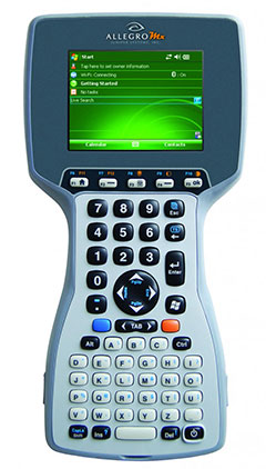
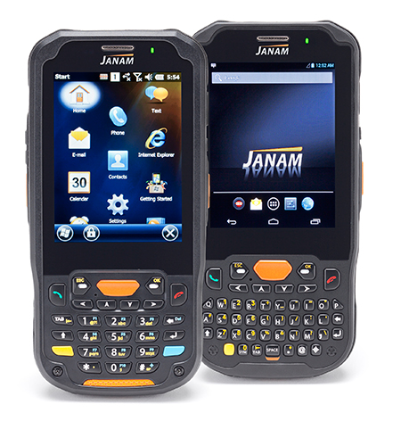
    Janam Technologies LLC, a provider of rugged mobile computers that scan barcodes and communicate wirelessly, today announced the launch of its XM5 family of rugged mobile computers. Designed to maximize the mobility investments of enterprise and government organizations, the new XM5 has high-sensitivity GPS and Assisted GPS, and supports Windows Embedded Handheld 6.5 and Android operating systems on the same hardware.

    Having both OS enables customers to choose the OS strategy and application migration schedule that best meet their mobility requirements, Janam said.

    The XM5 provides the power and flexibility required by mobile workers in field sales, field service, public safety, direct store delivery and transportation and logistics markets, Janam said. Customers can choose between integrated, best-in-class, 1D/2D imager or 1D laser scanner for instant decoding of the hardest-to-read barcodes. Embedded RFID and NFC reading capabilities ensure more efficiency and accuracy in a variety of applications including inventory management, asset tracking, personal identification and mobile point of sale.

    “Janam’s XM5 is one of the few rugged mobile computers that allows a customer to migrate from Windows to Android without purchasing new hardware,” said Harry B. Lerner, CEO of Janam. “Packed with all the features that enterprise requires, built to exacting standards of quality and available at an attractive price point, the XM5 catapults Janam to the lead position among hardware providers that not only listen to what customers need, but deliver to those requirements.”

    The XM5 comes with either a QWERTY or Numeric keypad and a specially-fortified 3.5-inch VGA display that withstands heavy-duty use. It also offers 802.11a/b/g/n dual-band WLAN and 4G-ready UMTS/HSPA+/HSDPA/HSUPA/GSM WWAN communications for access  to high-quality and reliable voice and data inside and outside the four walls.

    Built to withstand the rigors of everyday use in the enterprise, the XM5 is sealed to IP65 standards, can withstand five foot drops to concrete and is UL-certified for hazardous environments. In addition, the XM5 ships with a 4000mAh rechargeable Li-ion battery, providing extended battery life as a standard feature, not an optional one.

    XM5 Features

    • Android 4.2 and Microsoft Windows Embedded Handheld 6.5 operating systems
    • ARM Cortex-A8 processor @1GHz
    • 3.5 inch VGA fortified-glass display
    • Multiple 5’/1.5m drops to concrete
    • IP65 sealing against environmental elements
    • Embedded RFID and NFC capabilities
    • 3G/4G WWAN technology (UMTS/HSPA+/HSDPA/HSUPA/GSM)
    • 512MB/1GB with expansion capability
    • 802.11a/b/g/n Wi-Fi and Bluetooth
    • High sensitivity GPS and Assisted-GPS
    • Motion sensing accelerometer
    • 5.0MP autofocus camera
    • 3.5mm headset jack with Secure Lock
    • 4000mAh rechargeable Li-ion battery
  • Northrop Grumman Finishes Tests of Handheld Precision Targeting Device

    Northrop Grumman Finishes Tests of Handheld Precision Targeting Device

    Sgt. 1st Class Justin Rotti, a combat developer from the Training and Doctrine Command Fire Cell, Fires Center of Excellence, uses a developmental handheld precision targeting device during a test at White Sands Missile Range's 500k test site. White Sands' terrain and environmental features make it well suited for testing systems of this type. (Photo Credit: John Andrew Hamilton, ATEC)
    Sgt. 1st Class Justin Rotti, a combat developer from the Training and Doctrine Command Fire Cell, Fires Center of Excellence, uses a developmental handheld precision targeting device during a test at White Sands Missile Range’s 500k test site. White Sands’ terrain and environmental features make it well suited for testing systems of this type. (Photo Credit: John Andrew Hamilton, ATEC)

    A new handheld targeting system developed by Northrop Grumman will enable soldiers to engage targets with precision munitions while providing digital connectivity to related military units. The unit has successfully completed developmental testing at White Sands Missile Range in New Mexico, the company said.

    The Hand Held Precision Targeting Device, or HHPTD, locates, acquires, designates, marks and enables rapid target engagement with precision munitions and digital connectivity to the Joint Forces engaged in conflicts. The celestial navigation technology integrated in the system delivers improved robustness despite local magnetic variations and GPS-degraded or denied environments.

    The HHPTD weighs approximately five pounds and includes a GPS receiver and internal magnetic and celestial navigation technologies, as well as an internal high-definition color day and thermal night vision sensor and an eye-safe laser rangefinder. The system is compatible with external precision azimuth and vertical angle modules and provides precision target location information with digital video output, and digital communication for target location data, plus a capability for a near infrared laser pointer.

    Master Sgt. Rod Larreau, with U.S. Army Special Forces Command (Airborne), uses a targeting device at White Sands Missile Range's (N.M) 500k Site to identify targets during a test. White Sands provided a wide range of test targets, both in the form of official target boards as well as other facilities, that could be seen from the Soldier's observation point. (Photo Credit: John Andrew Hamilton, ATEC)
    Master Sgt. Rod Larreau, with U.S. Army Special Forces Command (Airborne), uses a targeting device at White Sands Missile Range’s (N.M) 500k Site to identify targets during a test. White Sands provided a wide range of test targets, both in the form of official target boards as well as other facilities, that could be seen from the Soldier’s observation point. (Photo Credit: John Andrew Hamilton, ATEC)

    The evaluation of the HHPTD was conducted by the U.S. Army’s Rapid Equipping Force, in partnership with the Army Program Executive Office’s Project Manager, Soldier Sensors and Lasers, and demonstrated the targeting device’s effectiveness in varying terrain and temperatures, ideal conditions for enabling the accurate gauging of the technology’s capabilities.

    Northrop Grumman’s Laser Systems business unit is delivering the HHPTDs to support in-theater operations of Department of Defense personnel. “This system is a lightweight, precision targeting device that addresses the targeting accuracy needed by our warfighters to help deliver today’s precision GPS munitions in all operational environments,” said Gordon Stewart, vice president and general manager, Laser Systems business unit, Northrop Grumman. “We have been uniquely successful in producing precision targeting enhancements to our systems through the use of celestial navigation technology.”

    The goal is to reduce friendly fire and collateral damage by improving the ability of the soldiers to differentiate between enemy combatants and non-combatants operating in very close proximity to one another. 

    To best evaluate the soldier capabilities of a targeting system, soldiers at White Sands tested a variety of technologies in varying terrain and temperatures, while recording observations and data in order to help set specific, detailed development goals and objectives for the program. Meeting specified requirements is important, but including soldiers early in the evaluation process ensures acquisition professionals meet Soldiers’ needs to develop suitable equipment. 

    These “soldier touchpoints” are critical to developing equipment that soldiers trust and will use in combat. “Testing at WSMR [White Sands Missile Range] gives us a better idea of how a system will work when deployed to theater,” said one soldier involved with the test. “I was able to really get a feel for how the technologies would be employed downrange.” 

    Northrop Grumman Laser Systems has developed the HHPTD and a family of handheld laser target location systems tailored to meet mission requirements in collaboration with FLIR Systems in Goleta, California, General Dynamics GIT in Nashua, New Hampshire, and Wilcox Industries in Portsmouth, New Hampshire.

  • u-blox SARA-U260 Module Receives AT&T Approval

    u-blox SARA-U260 Module Receives AT&T Approval

    The u-blox SARA-U260 module.
    The u-blox SARA-U260 module. Photo: Swiss u-box

    Swiss u‑blox says that its SARA-U260 dual-band 3G/2G module has achieved AT&T network compatible status.

    The certification allows customers to design SARA-U260 modems into M2M devices operating over AT&T’s extensive 3G network in the USA. Typical applications include small tracking boxes, usage-based insurance devices, smart metering, wearable electronics, and connected fitness watches.

    SARA-U260 is a complete 3G/2G voice/data module for applications that still require roaming ability with 2G using AT&T’s extensive 3G network coverage. The SARA-U260 provides full voice and data capability as well as a full suite of IP protocol stacks. The module features have been selected to give customers specific features they need for telematics units, handheld devices, communications modules, point-of-sale terminals, vehicle “black boxes,” and utility meters.

    SARA-U260 provides efficient and cost-effective mobile connectivity in a miniature 16 x 26 mm2 LGA form factor. The module is pin-compatible with SARA-G3 GSM/GPRS modules, as well as layout-compatible with LISA-U2 (HSPA) and TOBY-L2LTE modules to support future-proof 4G LTE designs.

    All SARA modules share the same form-factor and footprint and are designed based on u-blox’ “nested design” philosophy. This allows engineers to develop one hardware/software platform to support GSM/GPRS, HSPA, or LTE, depending on their end customer requirements.

    SARA-U260 hosts multiple embedded IP protocols, such as TCP/IP, UDP/IP, HTTP, and FTP. In-band modem support for automotive emergency calls like eCall and ERA/GLONASS are also integrated. With extremely low-power consumption, the SARA-U260 is designed for battery-powered and handheld devices.

    With direct A-GPS support for accelerated positioning and u-blox’ CellLocate hybrid positioning technology, SARA-U260 is designed to match u-blox advanced GNSS positioning capabilities, including indoor positioning.

    “u-blox is proud that AT&T certified our SARA-U260 module for its network,” said Nikolaos Papadopoulos, president of u-blox America. “Our robust voice and data modules deliver powerful 3G connectivity with 2G fallback in the smallest package on the market, at a price that customers recently paid for a 2G module.”

    For Europe and Asia, u-blox also offers the pin- and software compatible certified version SARA-U270.

    RIL software for Android and Embedded Windows is available free of charge from u-blox.

  • Fishy Business: Handhelds Help Remove Invasive Species from Utah River

    Fishy Business: Handhelds Help Remove Invasive Species from Utah River

    A Utah DWR field crew rides along in an electrofishing boat.
    A Utah DWR field crew rides along in an electrofishing boat.

    The Utah Division of Wildlife Resources (DWR)  is using rugged Juniper Systems handhelds in an innovative way: to remove an invasive fish species from the Green River so that native fish can flourish.

    A DWR field crew first used the Allegro MX handheld, loaded with custom fisheries software, to monitor native fish species and remove invasive fish in a 2013 project along the Green River, located near Dinosaur National Monument in Utah’s northeast corner.

    The field crew’s work involved boat electrofishing, in which the researchers ride along in a boat with electrodes protruding into the water. The electrodes send out an electrical current, temporarily stunning the fish.The fish float to the surface, where they are netted and inspected. 

    Invasive fish are collected and removed from the river. Invasive species can degrade fisheries habitats and harm the ecosystem. Right, the Allegro MX handheld.
    Invasive fish are collected and removed from the river. Invasive species can degrade fisheries habitats and harm the ecosystem. Right, the Allegro MX handheld.

    Every five miles, the crew stopped the boat and collected data on the fish. In a single day on a 12-mile stretch of the Green River, the crew caught 2,800 fish. 

    When a native species was caught, the fish was given a passive integrated transponder tag. Data was collected about the fish, and then it was released. When an invasive species was netted, however, it was kept for later data collection, and then removed from the river. Invasive species — fish transplanted from another location — can outcompete native fish, degrade fisheries habitats, and harm the ecosystem.

    With high-value native fish, the team took a GPS point and collected data on the species, length, weight, sex, ripeness, and more, explained Juniper Systems’ natural resources market manager Trevor Brown, who accompanied a crew.

    Brown explained that understanding the location of native fish helps fisheries biologists determine the effectiveness of previous removal efforts: Are native fish prospering in areas where invasive species were previously removed? Location also helps biologists associate where native fish are caught with habitat characteristics, which helps guide more targeted invasive removal efforts.

    Allegro MX handheld.
    Allegro MX handheld.

    Because the Green River is a a major tributary of the Colorado River, the boat crews submit their data to a central database that supports a larger effort to understand the status and health of fisheries systems of the entire Colorado River watershed. The information is used to guide management and policy decisions, fish regulations, and fisheries research.

    “Location-specific data can help biologists understand population and dispersal of both native and non-native fish at a macro level,” Brown said.

    The Utah DWR made the switch to the Allegro MX after seeing its benefits, including its full alpha-numeric keyboard, which allowed for rapid, accurate data entry, as well as its extreme ruggedness, sunlight-readable display, integrated GPS, and RFID compatibility. 

    The team even found the Allegro MX, rated IP67, could float — an additional bonus when working along a river in a shallow craft.

    Brown customized the fisheries software for the Utah DWR field crews. The crews previously collected data using pen and paper, and then manually entering it into Microsoft Excel, a time-consuming and error-prone process. The custom fisheries software, available through Juniper Systems, reflects the data that needs to be collected, with required data fields and streamlined data entry. Because many of the Utah DWR crews are made up of seasonal workers, Brown designed the fisheries app to be easy to learn and use.

    Biologists use the Allegro MX to collect data on the fish, including this endangered razorback sucker.
    Biologists use the Allegro MX to collect data on the fish, including this endangered razorback sucker.

    Northern Pike. Besides boat electrofishing, the fisheries software can be used for other applications, including an invasive fish removal application called fyke netting. Shaped like a bag with several hoops forming its structure, a fyke net acts as a funnel to trap swimming fish. The Utah DWR uses fyke nets primarily in the spring to trap invasive northern pike while they are spawning. After setting the fyke nets, crews return to check them and collect data on the trapped pike.

    The fisheries software is also used for tributary electrofishing data collection, in which wader-clad crews walk along tributaries with electrofishing backpacks, shocking the water. As in boat electrofishing, the crews collect the invasive fish for later data collection, and they tag and collect data on native fish before releasing them.

    The team experienced significant improvement with the new data collection process. “[The fisheries software] greatly reduced the data-entry time to the point where it has already paid for itself,” said Joe Skorupski, Native Aquatics Biologist at the Utah DWR. “Last year with three people, we took over 200 hours to enter, verify, and manipulate data. This year, it took one person 20 hours and errors were nonexistent due to the software and new data-collection process. I could go on and on about all the great improvements due to the handheld and the software.”

    Since 2013, the Utah DWR has expanded its use of the Allegro MX and software for parallel projects, such as native fish sampling on fast-moving sections (Flaming Gorge) of the Green River, where fewer invasive fish are present.

    Electrofishing probes temporarily stun the fish.
    Electrofishing probes temporarily stun the fish.
  • Septentrio, Imec Co-Design Antenna for High-Precision GNSS

    Septentrio, Imec Co-Design Antenna for High-Precision GNSS

    antenne copy-W
    photo: Imec and Septentrio

    Imec and Septentrio have collaborated to design multi-frequency GNSS antenna that simultaneously receives all GPS, GLONASS, BeiDou, and Galileo bands. Developed under the European Community’s Seventh Framework Programme project Handheld, the compact antenna can be integrated in multi-frequency handheld GNSS devices for high-precision location applications up to 1 centimeter.

    The announcement came at the Mobile World Congress being held this week in Barcelona, Spain.

    The compact antenna integrates Imec’s GNSS antenna and Septentrio’s GNSS RF front-end. Imec’s antenna design satisfies the requirements for the high-accuracy GNSS market while remaining small enough to fit in a handheld surveyor device, the companies said. The antenna has desired uniform gain and phase coverage over the complete upper hemisphere, with strong suppression of unwanted reflected signals below or in the vicinity of the GNSS receiver.

    The GNSS RF front-end, based on established front-end technology developed by Septentrio, is characterized by a superb out-of-band interference rejection to avoid notably device self-interference with other radiation sources such as Bluetooth and WLAN radios, as well as other ambient intentional and non-intentional interference. The compact multi-frequency antenna is a perfect companion of Septentrio’s compact and low-power AsteRx-m receiver, a credit card-sized dual frequency GNSS receiver that provides centimeter accuracy at less than 500-mW power consumption, by far the lowest power consumption in the professional GNSS market.

    The research leading to these results has received funding from the European Union Framework Programme (FP7/2007-2013) under grant agreement n°287183.

  • Juniper Systems’ Archer Field PC Records Elevation of Remote Himalayan Peak

    Juniper Systems’ Archer Field PC Records Elevation of Remote Himalayan Peak

    Juniper_Archer_on_Mountain
    Photo credit: Mark Fisher at www.fishercreative.com, Instagram: @fishercreative; via Juniper.

    Juniper Systems’ Archer Field PC has beenused to record the elevation of a never-before-climbed peak in the remote Myanmar Himalaya. The peak, Mount Gamlang Razi, has historically been known as the second highest peak in Southeast Asia, but a joint American-Myanmar-led expedition set out on a mission last September to hopefully prove that it is in fact the tallest. Read the whole story on Juniper Systems’ blog.

    Standing at a reported 5,881 meters tall, Mount Hkakabo Razi has long been known as Southeast Asia’s highest peak. In recent years, however, the legitimacy of the elevation of Hkakabo Razi has come into question. Current digital analysis suggests that initial surveys of Mount Hkakabo Razi were overstated and its actual elevation is as much as 100 meters lower than originally believed. At the same time, digital analysis suggests that virgin-peak Gamlang Razi may in fact be the taller peak. This controversy prompted Idaho resident and experienced climber Andy Tyson to lead an American-Myanmar expedition team on a three-week approach through 150 miles of cobra-riddled, mosquito-infested jungle, and from there up to the peak of Gamlang Razi to measure its elevation in person.

    Tyson needed a device that could accurately record the elevation at the summit, while being able to withstand the extreme conditions of the hot, wet jungle and the frozen mountaintop. With this in mind, Tyson requested from Juniper Systems a top-of-the-line rugged handheld. In response, Juniper Systems provided the team with an Archer Field PC with Hemisphere GPS XF101 receiver, along with training to record the GPS data they needed.

    Setting up the Archer Field PC to collect GPS data. Photo credit: Mark Fisher at http://www.fishercreative.com. Instagram: @fishercreative
    Setting up the Archer Field PC to collect GPS data. Photo credit: Mark Fisher at http://www.fishercreative.com/Instagram: @fishercreative/via Juniper.

    After a 35-day journey, Tyson and the team successfully summited Gamlang Razi, with the Archer Field PC in hand. After collecting GPS data at the top, the data was sent via satellite phone to Juniper Systems for analysis. After post-processing the data against terrestrial base stations in Lhasa, Tibet, and confirming the results with Effigis in Montreal, Canada, Juniper Systems concluded that the elevation of Gamlang Razi was 5,870 meters, ±2 meters. This suggests that Gamlang Razi is taller than nearby Hkakabo Razi by approximately 112 meters and should be considered Southeast Asia’s new highest peak.

    However, there are many — particularly natives to Myanmar — who are not ready to accept changes to Hkakabo Razi’s original elevation measurement. This was made apparent in a letter Myanmar’s president, Thein Sein, wrote to Tyson and the team after their successful summit, congratulating them for summiting Southeast Asia’s second-tallest peak.

    Tyson remains firm in his assertion that Gamlang Razi is the country’s highest peak, but some have suggested that the debate may not be over until someone actually climbs Hkakabo Razi and measures it in person. Juniper Systems said they have a handheld for the job, should that time come.

    The expedition team. Photo credit: Mark Fisher at http://www.fishercreative.com. Instagram: @fishercreative
    The expedition team. Photo credit: Mark Fisher at http://www.fishercreative.com. Instagram: @fishercreative/via Juniper.
  • Garmin Golf Introduces Two Touchscreen Handhelds

    Garmin Golf Introduces Two Touchscreen Handhelds

    Garmin Approach G8,
    Garmin Approach G8,

    Garmin International has introduced two new handhelds geared for the golf aficionado, including a new top-of-the-line model, the Approach G8.

    The Approach G7 and G8 golf handhelds have color touchscreens, more than 30,000 preloaded international courses, a rechargeable battery capable of multiple rounds, and new measurement features such as PlaysLike Distance, which shows adjusted range for uphill and downhill shots.

    For golfers who prefer to leave their smartphones in their bags, the new Approach handhelds offer Smart Notification technology, which lets the user pair a compatible iPhone 4S or later to receive emails, texts, and call alerts on the device (Android compatibility is expected in the second quarter of this year). The devices are also compatible with Garmin Connect, so users can upload their scores and track their progress over time.

    Both the Approach G7 and G8 incorporate the new measurement feature PlaysLike Distance, which adjusts distances for uphill and downhill shots, so players get the most accurate yardage measurements. Both devices also offer Club Advice, which remembers how far users hit each club and makes recommendations based on shot distances.

    Another new feature in the G7 and G8 golf handhelds is the Big Numbers mode, so users can easily see the vital information they need without squinting or reading glasses.

    The Approach G7 and G8 handhelds come preloaded with more than 30,000 international courses, with no extra subscriptions or fees. Both devices give precise distance to the front, back and center of the green, as well as layup and dogleg distances. Both devices have a rechargeable battery that plays an entire weekend of golf (15 hours) on a single charge.

    The Approach G7 and G8 double as digital scorecards with scoring options for Stroke Play, Stableford, Skins and Match Play with adjustable handicaps. Users can save, review, share and print scores for up to four players. With the vibrant screen, the G7 and G8 offer colorful layup arcs at 100, 150, 200 and even 250 yards, so users know exactly how far to hit when laying up.

    The Touch Targeting feature lets users touch any point on the display, and will give the precise distance to that exact spot, no matter if it is on the fairway, a hazard, a landing area, or even the front, middle or back of the green.

    Like other Approach devices, the G7 and G8 have Green View, which allows users to zero in on a map of the green and manually position the pin in order to get the most accurate yardages. There is also an advanced Stat Tracking feature in the G7 and G8, which keeps track of fairways hit, greens in regulation and putts per round. These stats can be viewed during the round, or can be downloaded afterwards.

    The premium Approach G8 also provides blind shot assistance with the new PinPointer feature, which shows the user the exact center of the green even if it’s not visible, and points them in the right direction for more accurate blind shots. Additionally, it adds Wi-Fi, so the G8 will automatically update courses when connected to Wi-Fi at no additional cost. The G8 rounds out the Approach family as the top-of-the-line golf handheld from Garmin.

    New to the Garmin golf lineup, the Approach G7 and G8 will now be compatible with Garmin Connect. With the recent revamp of the online community, owners with Approach G7 and G8 will be able to upload, analyze and share their scorecards, as well as other data like fairways hit, greens in regulation, shot distance and number of putts. Users can keep track of whom they’ve played against, and who won each round. They can analyze course data, and see hole-by-hole details to understand their own trends and tendencies to improve their game. This is great to track users’ progress and improvements over time for every course they play.

    Rugged, and with a water rating of IPX7, the Approach G7 and G8 are durable enough to withstand a rainstorm, or users’ golf bags without fear of damage. The Approach G7 and G8 will be available in Q1 2014. The Approach G7 will retail for $299.99 and the Approach G8 will retail for $399.99, and will be available at specialty golf retailers, golf course pro-shops and on garmin.com.

  • Garmin Introduces GPSMAP 64 Series Outdoor Handheld

    Garmin Introduces GPSMAP 64 Series Outdoor Handheld

    Garmin's GPSMAP 64 device.
    Garmin’s GPSMAP 64 device.

    Garmin International Inc., a unit of Garmin Ltd., today announced the GPSMAP 64 series of rugged outdoor handhelds. The GPSMAP 64 series brings a dual GPS and GLONASS receiver, preloaded geocaches and smartphone connectivity for LiveTrack and Smart Notification to its product line for hikers, hunters, and geocachers.

    “Building on the popularity of the GPSMAP series, the new GPSMAP 64 series improves functionality to make a top-notch device even better,” said Dan Bartel, Garmin vice president of worldwide sales. “The GPSMAP 64 is ideal for anyone, no matter if it’s their first handheld, or if they’ve used Garmin for years. It combines trusted Garmin technology with the comfort of a device people know and love.”

    The GPSMAP 64 series has a 2.6-inch sunlight-readable transflective color display and a high-sensitivity GPS and GLONASS receiver with a quad helix antenna for superior reception. With the addition of GLONASS satellites, the time it takes for the receiver to lock on to a position is (on average) approximately 20 percent faster than using GPS alone. This allows users to get their position quickly and precisely even in heavy cover and deep canyon.

    The GPSMAP 64 series features three distinct water-resistant (IPX7) models to suit various activities and interests. The basic GPSMAP 64 includes a built-in worldwide basemap with shaded relief, and supports BirdsEye Satellite imagery and TOPO U.S. 24K maps. The GPSMAP 64s adds a 3-axis electronic compass and barometric altimeter. Additionally, the 64s adds wireless connectivity for data transfer between other compatible Garmin handhelds and mobile apps, and for Smart Notification technology. With this, users can receive emails, texts and alerts on the device (when paired with an iPhone 4S and later). This allows users’ smartphones to be safely protected from the elements. The 64s also comes with a one-year subscription of BirdsEye Satellite Imagery. The GPSMAP 64st includes preloaded U.S. 100K topographic maps. With this, users will be able to search for points of interest by name or proximity to their location and view descriptive details for terrain contours, topo elevations, summits and geographical points.

    For outdoor adventurers, the rugged GPSMAP 64 devices are compatible with BaseCamp, a free software download that allows users to view and organize maps, waypoints, routes and tracks. The 64s and 64st models are compatible with the BaseCamp mobile app for data transfer, and the Garmin Connect mobile app, for features such as LiveTrack. With LiveTrack, users can pair their device with the app, and invite friends and family to follow their activity in real time. This provides peace of mind, especially if users are alone. Through ANT+, the 64s and 64st models are also compatible with external sensors such as an external temperature sensor and heart rate monitor. With ANT+, the 64s and 64st models can act as a remote for the new VIRB and VIRB Elite action cameras.

    Each device comes preloaded with the locations of 250,000 geocaches from Geocaching.com. Devices store and display key information to find the hidden containers including the geocache coordinates, terrain rating, its difficulty, hints and descriptions, so users no longer have to manually enter coordinates or print out geocache info. By going paperless, users are helping the environment, and improving their efficiency. If users would like to continue geocaching beyond the preloaded geocaches, when they register their device they can sign up for the free premium membership trial through Geocaching.com, and download more geocaches. The GPSMAP 64 devices can store millions more, so users will no longer have to pick and choose which geocaches they want to load on their device.

    All of the devices in the GPSMAP 64 series have a dual-battery system, where both standard AA batteries and a rechargeable NiMH battery pack (sold separately) can be used. The devices have internal memory (4GB for 64/64s and 8GB for 64st), and a microSD card slot to store additional data and maps.

    The new GPSMAP 64 series will be available this month. The GPSMAP 64 will retail for $299.99, the GPSMAP 64s will retail for $399.99, and the GPSMAP 64st will retail for $499.99.

  • Carlson Launches Two Handhelds at Intergeo

    Carlson Launches Two Handhelds at Intergeo

    Carlson Software has introduced a new and improved version of its affordable Qmini data collector. The rugged, but lightweight Qmini2 provides fast processing, yet fits comfortably in one hand.

    Carlson also launched the Carlson MINI2 data collector, which is more rugged, fast, and reliable than its predecessor. It comes with a numerical keyboard for easy coding of points.

    Both products were introduced at Intergeo, being held October 8-10 in Essen, Germany.

    Photo: Carlson Software
    Photo: Carlson Software

    The Qmini2. Weighing 11 ounces (315 grams), the Qmini2 includes a 5 megapixel camera and has a 3.7-inch (480 x 640) sunlight-readable display and comes with a stylus for ease of use. Other specifications include:

    • Works on Windows Mobile 6.5 OS with a PXA310 processor 806Mhz, 256 RAM
    • Provides 8GB non-volatile data storage plus a micro SD card slot
    • Comes with Bluetooth (200-250 meter range to CRx with BT handle), WiFi, Internal GPRS module (data and voice) capabilities
    • Has an internal 32-channel GNSS receiver (GPS + GLONASS) with SBAS (WAAS, EGNOS, MSAS) support
    • Rated IP65 waterproof and dustproof

    The Qmini2 comes with two batteries, a U.S. wall charger, and a soft carrying case. It may be purchased with Carlson’s SurvCE data collection software on board, or with Carlson GIS360, which uses both GIS and surveying technology in the field to collect data. For crash or crime reconstruction, The Qmini2 may also be used with Carlson’s CSI Mobile software.

    For more information or to see the Qmini2 in action, stop by the Carlson Stand #3.097, Hall C, or outdoors at #100 at Intergeo, Oct. 8-10 in Essen, Germany.

    The Carlson MINI2.
    The Carlson MINI2.

    The MINI2. Manufactured to Carlson’s exacting specifications by Juniper Systems, the MINI2 has an extra-large 800 × 480 TFT display for easy viewing of survey data and comes with a fast 1.0-GHz processor. It comes with an integrated 3G modem, 5-megapixel camera, and GPS/GNSS module.

    Its scratch-resistant, touchscreen display is highly readable in both low light and glaring sunshine, providing a sharper image together with notable durability in tough conditions. With a dustproof and waterproof rating of IP68, the Carlson MINI2 also meets the MIL-STD-810G military standard.

    The Qmini2 will be available for purchase from your local dealer on November 1.

    Both products can be viewed at Intergeo Stand #3.097, Hall C, or outdoors at #100. at Intergeo.

  • Handheld Ships New Version of Algiz 7 Tablet

    Handheld Group has announced the launch of the new version of its popular Algiz 7 rugged tablet computer. The updated Algiz 7 is considerably faster than its predecessor, with better storage capacity, improved security and quicker communication capabilities.

    According to the announcement, the ultra-rugged Algiz 7 tablet PC is small, light and fast, with multiple connectivity options and a wide range of functions, ideal for field workers demanding a super-durable product that is tough and powerful, yet light and easy to work with. The Algiz 7 meets stringent MIL-STD-810G military standards for withstanding humidity, vibrations, drops and extreme temperatures, and with its IP65 rating it keeps dust and water out as well.

    Algiz-7-handheld-tablet-facing-left-newThe new Algiz 7, which started shipping this week, features the following improvements from earlier versions:

    • A fast and powerful N2600 1.6 GHz Dual-Core Intel ATOM processor.
    • More memory, with 4 GB of DDR3 RAM.
    • Better storage, with a 128GB SSD SATA II with recovery partition.
    • Two full mPCIe slots for improved flexibility.
    • Ethernet 10/100/1000 (Gigabit).
    • Added data security with TPM chipset board (chip 1.2).
    • An updated version of the wireless Gobi 3000 technology for higher communications speed.
    • A 5-megapixel camera.
    • Antenna diversity (two antennas) for improved coverage.

    “We’ve made significant improvements to the new Algiz 7,” said Jerker Hellström, CEO of Handheld Group. “Better storage, a much faster processor, improved security, a better camera and better communications are some enhancements – and we’ve kept the price point the same as for the previous version of the Algiz 7. This product should remain the tablet of choice for anyone looking for portable, professional field performance.”

    The Algiz 7 weighs 1.1 kilograms and has a 7-inch widescreen touch display that features the new and unique MaxView technology, providing brightness in outdoor conditions — even direct sunlight. It runs the state-of-the-art Microsoft Windows 7 Ultimate operating system. GPS navigation functionality is fully built in.

    The Algiz 7 is specifically developed for use in tough environments in industries such as mining, geomatics, logistics, forestry, public transportation, construction, utilities, maintenance, military and security.

  • CHC Offers LT400HS GNSS Handheld

    CHC Offers LT400HS GNSS Handheld

    CHC
    The LT400HS GNSS by CHC.

    CHC today announced the availability of the LT400HS, a rugged 120-channel GPS+GLONASS handheld receiver designed to achieve sub-meter SBAS positioning to centimeter accuracy in RTK networks. The LT400HS is designed to be a cost-effective yet powerful GNSS device for survey, construction and GIS professionals.

    The LT400HS is designed for companies that have not yet invested in GNSS technology due to cost or occasional equipment use, such as earth-moving and landscape contractors, real estate developers, construction SMEs, agriculture irrigation companies, and utilities mapping companies.

    “The LT400HS GNSS handheld series is a compact, rugged, accurate and easy-to-use GNSS receiver to perform surveying and precision mapping tasks wherever RTK Network corrections are available,” said George Zhao, CEO of CHC. “The LT400HS offers unrivaled performance, an attractive price point filling the price performance gap that exists in the industry between GIS level collectors and professional RTK rovers such as our recently introduced X+ GNSS Series. ”

    The LT400HS Series features:

    • Professional 120-channel GNSS Engine – L1/L2 GPS + GLONASS supporting RTCM network RTK corrections and industry standard NMEA output.
    • 3.7” daylight readable transflective VGA touch screen.
    • Built-in GSM/GPRS phone with data transmission, Bluetooth and Wi-Fi connectivity.
    • Built-in 5 megapixel autofocus camera to capture assets information.

    It comes bundled with Carlson’s SurvCE software for survey and construction professionals, or DigiTerra Explorer Mobile GIS software  for accurate GIS field data collection and maintenance.

  • Handheld Launches the Algiz 10X, a 10-inch Rugged Tablet for Outdoors

    Handheld Group, a manufacturer of rugged mobile computers and smartphones, today announced the launch of its new rugged mobile device for field professionals, the Algiz 10X  rugged tablet PC. The Algiz 10X can withstand tough weather elements and harsh handling. It has a large, 10.1-inch touchscreen.

    “The new Algiz 10X is perfectly suited for field professionals who need a rugged tablet computer that is lightweight and built to withstand the harsh conditions that come with all kinds of industry fieldwork, and that can display detailed maps and other visuals even in bright sunlight,” said Jerker Hellström, CEO of Handheld.

    The Algiz 10X is IP65-rated and meets stringent MIL-STD-810G military standards for protecting against dust, water, vibrations, drops, extreme temperatures and varying altitudes. It is lightweight at 1.3 kg (2.9 lbs), and  32 mm (1.2″) thick.

    The Algiz 10X’s brilliant display features the latest generation of MaxView technology. The tablet also comes with a u-blox GPS receiver and WAAS/EGNOS/MSAS capability, plus Bluetooth 4.0, WLAN 802.11 b/g/n and it is WWAN Gobi 3000-ready with fully integrated modem and antennas for wireless connectivity. It has a built-in 5-megapixel camera with LED flash, and several connectivity opportunities, including waterproof USB 2.0, VGA and RS232 ports. The Algiz 10X operates on a powerful Intel Atom N2800 dual-core processor with 4 GB of DDR3 RAM, offering top-of-the-line computing capability, and the SSD disk is expandable via microSD for massive storage capacity. The Algiz 10X runs Windows 7 Ultimate, and is ready for Windows 8.

    “With the Algiz 10X, we are expanding the popular product family that includes our Algiz 7, which is the preferred choice today for field professionals worldwide. The Algiz 10X comes with increased processing power and storage plus a larger display — something that the market has been asking for,” said Hellström.

    Like all of Handheld’s lineup of rugged PDAs, smartphones and mobile computers, the Algiz 10X is specifically developed for field workers in industries such as geomatics, logistics, forestry, public transportation, utilities, construction, maintenance, mining, military and security.

    The Algiz 10X rugged tablet PC is being showcased at INTERGEO in Hanover, Germany, on October 9-11, and will be shown Mobility for Business in Paris, France, on October 10-11, plus several shows throughout the fall.

    The Algiz 10X will be available in January 2013. Orders can be placed immediately.