Lochbridge, a provider of automotive connectivity services and solutions, is presenting and exhibiting at TU-Automotive Detroit 2016, held June 8-9 in Novi, Michigan.
Through the company’s keynote presentation, newly released maturity model and suite of connected solutions, Lochbridge will demonstrate how OEMs need connectivity to create a competitive edge.
Lochbridge’s keynote presentation, “Are Your Connected Cars Ahead of the Curve?,” will unveil a new model that maps connected-car investments to the core outcomes of connectivity — loyalty, differentiation, monetization and quality. Delivered by Raj Paul, vice president of IoT & Connected Services, the presentation will show how connected solutions — including predictive analytics, OTA updates and digital integration — can be leveraged to achieve these outcomes. Using this model, Paul will present an industry scorecard to highlight how well OEMs today are applying connected solutions to gain a competitive edge. Lochbridge’s keynote presentation is scheduled at 2 p.m. ET on June 9.
At TU-Automotive Detroit 2016, the Lochbridge team will also be showcasing a suite of new connected vehicle solutions at booth 204:
Risk Analytics: Demonstrating how usage-based insurance (UBI) progresses in parallel with the future world of urban mobility where drivers will carry a “lifetime-driving-score.” In collaboration with Harris Corporation integrating the Helios environmental intelligence platform, traditional driving behavior data, such as hard braking and accelerating, is combined with real-time contextual data, such as road conditions and environmental conditions.
App Certification Ecosystem (ACE 2.0): Providing a cloud based “virtual bench” that allows developers to bring new ideas to life faster while offering OEMs control of the application development, certification and support process.
IoT Device Management Platform: Enabling car manufacturers to extend new vehicle enhancements and manage recalls through a single solution. The solution provides OEMs a robust device management and Over-The-Air capability (OTA) supporting upgrades en masse or at an individual level.
Fleet Management: Integrating Oracle’s IoT Cloud Service platform, the new fleet concept demonstrates how device tracking, management and analytics can be deployed with rigor rapidly.
Hands-on demonstrations of all four connected solutions will be available at Lochbridge’s exhibit at booth 204.
“It’s no longer about developing new and cool features. Connected car solutions need to provide automakers a competitive edge in the market and help create a great customer experience,” said Romil Bahl, Chief Executive Officer, Lochbridge. “We are excited to debut our new model and a suite of solutions that will allow our automotive clients to unlock new opportunities, drive growth and create value.”
The first GPS III satellite in accoustic testing. (Photo: Lockheed Martin)
Harris Corporation will offer an all-digital navigation payload for GPS III Space Vehicles (SV) 11 and beyond.
According to Harris, the fully digital navigation payload will provide enhanced performance and enable on-orbit reprogramming. The all-digital payload expands on the advanced features of the current 70-percent digital payload that Harris provides for Lockheed Martin’s GPS III SV 1-8 satellites.
The features provide greater flexibility, affordability and accuracy compared to existing satellites and include an advanced modular design, atomic clock timing systems, radiation-hardened computers and powerful transmitters.
The new payload combines innovative digital capabilities developed by Harris and Exelis, now a part of Harris. In 2013, Exelis successfully demonstrated digital navigation signal capability in a formal preliminary design review conducted by the Air Force.
The payload also leverages the mature Technology Readiness Level 9 legacy Harris reconfigurable payload that is flying on the International Space Station and is incorporated on hosted payloads for the Iridium NEXT satellite.
Harris has more than 500 digital processors on-orbit and another 150 awaiting launch. Harris navigation payloads have been on all of the 80-plus U.S. GPS satellites launched since the 1970s, with more than 750 years of on-orbit life without a payload-related failure. Harris has delivered more than 100 digital payloads, which have performed flawlessly on-orbit, the company said.
Harris will provide a fully digital payload for GPS III satellites beginning with SV11. Shown is SV1 in testing. (Photo: Lockheed Martin)
The first and best step to combat the growing worldwide problem of GPS jamming is to pursue technologies that can detect and locate the jammers. Signal Sentry 1000 uses arrayed sensors to do just that: look out for jamming and track down its source once sensed.
An array of sensors can be deployed for sensitive and high value entities such as infrastructure installations, including airports, railroads, chemical plants, electric power plants and grids, cargo ports, wireless communication systems and financial transfer centers. The sensors will connect to servers that assimilate the sensor data and provide operator interfaces.
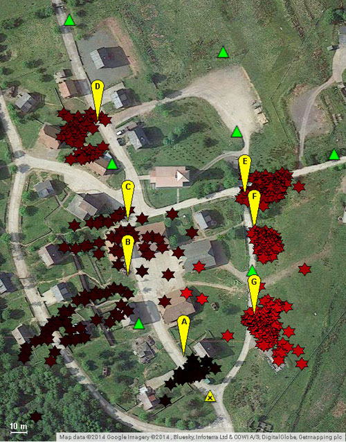
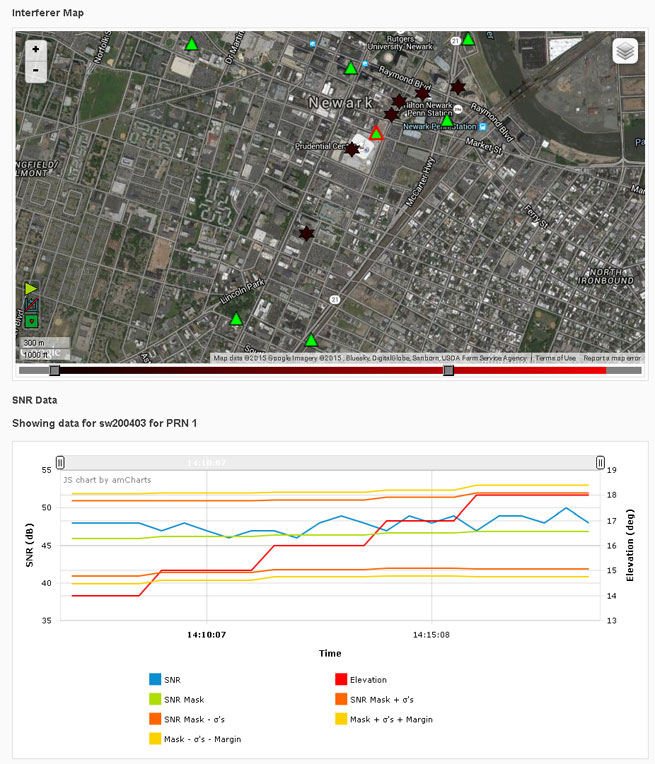
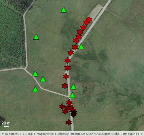
Signal Sentry 1000 is based on a server/client model. The user accesses Signal Sentry using a URL and secure log-in specific to the user’s system. The user’s particular home screen displays a map with each installed sensor displayed with an icon reflecting status. Interferers are displayed as red stars or as error ellipses.
The Signal Sentry web page lists all the interferers stored in the database with their start and end times. The user can manipulate the list by changing the minimum duration of the event to be displayed as well as if the interferer had been geolocated or not, or both. If an interference event was less than a minute long, it may not have a geolocation entry.
Geolocation Methodology. Geolocation of jammers is accomplished through proprietary algorithms running at the network server that utilize digitized, timestamped I and Q samples of received interference waveforms, GPS observables, and other parameters captured by each sensor. This data is processed in a Kalman-filter based location algorithm to determine an initial jammer position and track the position of the jammer throughout the jamming event. This improves performance with moving jammers (that is, vehicle-based) and enables continued jammer location with a limited sensor set (potentially due to signal blockage, erroneous data due to multipath, or out-of-range conditions). Upon detection of an interference event by any sensor, the server polls the entire sensor network for data and determines if the information is sufficient to perform geolocation.
The user receives near-real-time status of event detections and geo-location of the interferer (if possible). Sensor data polling, geolocation processing and GUI updates continue until the interference stops or the emitter goes out of sensor range. Sensor data from each event is stored for later replay and processing using Signal Sentry event analysis tools.
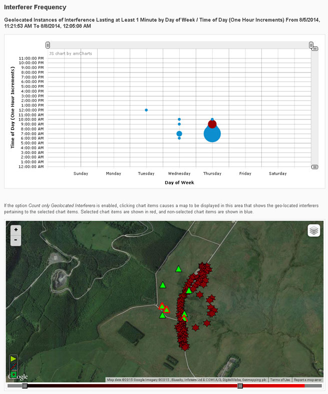
An interference event frequency chart (Figure 1) provides a tool for forensically evaluating the occurrence of interferers. It displays interference events as circles; the size of the circle represents the number of events that occurred at that day of the week and time. When dots are selected on the chart, a map below the chart shows the location of the interference events. More than one dot can be selected at a time. This allows a user to find correlations in time and space, to determine if events occur at specific locations at certain times of the day and/or days of the week.
FIGURE 1. Interference event frequency chart.
Selecting the interferer on the map and then the details button on the popup brings up the interferer details page (Figure 2). Users can sign up for interferer alerts to be sent to their email or phone by text.
FIGURE 2. Interferer details.
Testing
Signal Sentry 1000 was deployed and tested in GPS jamming trials at Sennybridge, United Kingdom, in August 2014. Testing included stationary jammers and mobile jammers moving at up to 50 mph, in open fields and built-up areas.
Sentry Arrayed. The sensors used in these trials were custom units designed and built to Harris specifications by Chronos Technology Ltd. Each consisted of an embedded GPS receiver, an interference signal receiver and a local processor with a network communications interface.
An array of eight sensors was geographically distributed around the test facility. Each sensor and a centralized Signal Sentry processing server were equipped with a mesh data networking capable radio for wireless data communications of commands, status and event data. In other Signal Sentry deployments, the server software is typically hosted on a cloud server, and sensors communicate with the server either via hard-wired internet connections or wirelessly through cellphone network-compatible data adapters.
Jammer Profile. Two jammers performed during the trials, a 150mW and a .5W jammer, used to disrupt the GPS L1 C/A code at 1575.42 MHz.
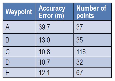
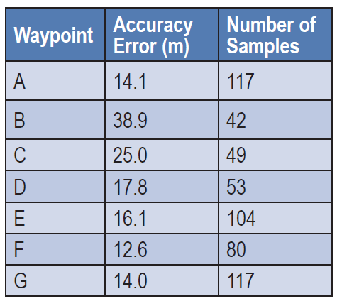
Open Field. Atest in an area with no obstructions included static jammers and dynamic jammers. Five waypoints along the road, in an area measuring 320 by 444 meters, were surveyed prior to the test using a handheld GPS receiver, to evaluate location accuracy.
Table 1 shows static test results. The accuracy error is the average delta between the Signal Sentry-reported jammer positions versus the actual surveyed jammer positions. The number of points column contains the number of measurements reported by Signal Sentry during the test scenario for each waypoint. The overall average accuracy error for the static jammer test was 17.25 meters.
TABLE 1. Open field static accuracy.
Open Field, Mobile Jammer. In these tests, the jammer was driven in a car on the road through the sensor field. The car was driven at 25 mph north to south, then 50 mph south to north (Figure 3). Cars in the north parking lot caused multipath errors when the jammer came in contact with that area.The overall average accuracy error for the dynamic tracking was 10 meters.
FIGURE 3. Jammer locations detected by Signal Sentry, when jammer was driven at 50 miles per hour, north to south. Green triangles denote sensor locations.
Obstructed Area Test. This test evaluated performance in an urban environment called a FIBUA (Fighting in Built-up Areas), using stationary and dynamic jammers. Seven waypoints in an area 176m x 253m were surveyed for the purpose of evaluating location accuracy. Table 2 shows the results with the 150mW jammer held stationary at the waypoints. Figure 4 provides a graphical view of the jammer position in relation to the waypoints. The overall average accuracy error is 21.40 meters.
TABLE 2. Urban static accuracy.
Obstructed Area, Mobile Jammer. In these tests, the jammer was driven in a car at approximately 20 mph on the road through the sensor field, using a .5W jammer. The overall average accuracy error for this dynamic tracking was 50 meters.
FIGURE 4. Urban area test; jammer locations in yellow, locations delivered by Signal Sentry in red, sensor locations in green.
All figures provided by Jeffrey Coffed and Joseph Rolli.
exactEarth Ltd. and Harris Corporation have formed an alliance to provide a new level of Satellite Automatic Identification System (AIS) data service that will deliver real-time global coverage for maritime vessel tracking. The new service will leverage the persistent global coverage and real-time connectivity of the Iridium NEXT constellation through the implementation of 58 hosted payloads covering the Maritime VHF frequency band.
Harris is a space, geospatial and remote sensing company, and exactEarth is a provider of AIS data services.
Compatibility testing of the hosted payload with the Iridium satellites has been completed. The first launch is scheduled for early 2016, with the completed constellation expected in 2017. The new service will provide customers with the fastest, most accurate vessel information available. With revisit times and latency under one minute, the service expansion represents a leap forward in the ability for both Harris and exactEarth to offer global ship tracking and maritime information solutions, the companies said in a statement.
The alliance leverages exactEarth’s proven and patented signal de-collision detection technology and Harris’ expertise in satellite hosted payloads, advanced radio frequency technology and antenna solutions. Harris becomes the exclusive provider to the US government of AIS products and services produced under the alliance, including exactEarth’s exactAIS product portfolio, while exactEarth continues to serve all other global markets.
“This alliance will expand our IntelliEarth family of innovative solutions, which leverage Harris’ world-class remote sensing capabilities to help customers around the globe make smarter operational and business decisions,” said Bill Gattle, vice president and general manager, National Programs, Harris Government Communications Systems. “Harris is committed to exploring new technologies and partnering with world-leading organizations to provide our customers with the greatest value.”
“As the recognized Satellite AIS industry leader, this announcement further strengthens our commitment to provide best-in-class maritime intelligence solutions to our customers worldwide,” said Peter Mabson, Ppresident of exactEarth. “We are thrilled to be able to offer the shortest revisit times and lowest latency for developing true maritime domain awareness. This partnership with Harris will allow us to significantly expand the range of advanced value-added services and information solutions that we can bring to the global maritime market.”
Harris Corporation and Exelis Inc. today announced a definitive agreement under which Harris will acquire Exelis in a cash and stock transaction valued at $23.75 per share, or an approximately $4.75 billion enterprise value. The agreement has been unanimously approved by the boards of directors of both companies.
The transaction is expected to close in June 2015 and is subject to customary closing conditions, including regulatory and Exelis shareholder approval.
Exelis is a global aerospace, defense, information and services company with a 50-year legacy. It was previously under the ITT Corporation umbrella, but spun off in 2011. Headquartered in McLean, Va., Exelis employs about 10,000 people.
Exelis employs about 10,000 people. the combined Harris/Exelis company will have about 23,000 employees. including 9,000 engineers and scientists.
One of Exelis’ biggest product offerings in the past year has been its Signal Sentry 1000, which detects and locates sources of intentional and unintentional interference to GPS signals and provides users with actionable intelligence. Exelis navigation payloads and components have been on board every U.S. GPS satellite ever launched and have more than 700 years of accumulated on-orbit success.
Harris is an international communications and information technology company serving government and commercial markets in more than 125 countries. Headquartered in Melbourne, Fla., the company has about $5 billion of annual revenue and 13,000 employees. Harris is engaged in a five-year contract with Aireon LLC that will create the first global satellite-based aircraft tracking system. The company’s Automatic Dependent Surveillance-Broadcast (ADS-B) 1090 Extended Squitter receiver payload has been successfully tested and qualified for simulated operation in the harsh environment of space for more than 12 years.
Under the terms of the transaction, Exelis shareholders will receive $16.625 in cash and 0.1025 of a share of Harris common stock, based on Harris’ closing price as of Feb. 5, for each share of Exelis common stock. Upon closing, Harris shareholders will own approximately 85 percent of the combined company, and Exelis shareholders will own approximately 15 percent. On a pro forma basis for the latest 12 months ended Dec. 31, 2014, the combined company would have had more than $8 billion in revenue and about 23,000 employees globally, including 9,000 engineers and scientists.
“Acquiring Exelis is transformational for Harris,” said William M. Brown, chairman, president and chief executive officer of Harris. “The combination of the two companies’ highly complementary core franchises creates a competitively stronger company with significantly greater scale. We are expanding in a market, where we have decades of success and a workforce dedicated to providing our customers with innovative and cost-effective solutions for some of their most complex challenges.”
“This agreement to become part of Harris Corporation represents an exciting new chapter for Exelis,” said David F. Melcher, chief executive officer and president of Exelis. “Combining the companies not only creates shareholder value, but the commitment to excellence and innovation that both companies share will significantly benefit customers and provide new opportunities for employees.”
Melcher also noted, “Our 2014 was another strong year, and we expect to report revenue of approximately $3.25 billion and adjusted operating margin between 12.4 and 12.5 percent, which is in line with our previous guidance.” Exelis indicated that approximately $25 million of its anticipated free cash flow for 2014 shifted into 2015 due to some delayed collections, but that its estimate for 2015 free cash flow is being increased to approximately $275 million. Exelis also expects depreciation and amortization of approximately $106 million in 2014, net debt of $139 million and a net unfunded pension liability of approximately $1.9 billion at the end of 2014. Exelis ended the year with an estimated $2.8 billion in funded backlog.
Integration plan. Harris said it has developed a detailed execution plan to ensure seamless integration and achieve identified cost synergies. The dedicated integration team will have executive leadership and be comprised of senior members of both organizations. Harris is confident in its ability to effectively combine these two companies and provide the organizational alignment to achieve full strategic value, the company stated in a news release.
At the 2014 ION GNSS+ Conference Sept. 9-12 in Tampa, Fla., Lori Thompson of Exelis provided GPS World readers with updates about the company’s activities.
Harris Corporation has achieved a key milestone under a five-year contract with Aireon LLC that will create the first global satellite-based aircraft tracking system. The announcement was made during the SATELLITE 2014 Conference and Exhibition, held March 10-13 at the Washington Convention Center in Washington, D.C.
The company’s Automatic Dependent Surveillance-Broadcast (ADS-B) 1090 Extended Squitter receiver payload has been successfully tested and qualified for simulated operation in the harsh environment of space for more than 12 years. Simulated performance testing also validated the agility of the payload to adapt to evolving aircraft traffic patterns over the same span of time.
Harris is providing Aireon with 81 of the ADS-B receiver payloads. They will be hosted on board the Iridium NEXT satellite constellation to enable precise aircraft tracking that will optimize air traffic management around the world. Ground-based ADS-B networks, which process GPS signals and other data from aircraft, are limited by an infrastructure that cannot monitor flights over oceans or remote regions, a limitation now highlighted by the disappearance of a Malaysia Airlines jetliner on March 8.
The Harris payloads are based on the company’s AppStar reconfigurable payload platform. They will be mounted on 66 low Earth-orbiting satellites, six on-orbit spares and nine ground spares that comprise the Iridium NEXT constellation. The air traffic surveillance function will be performed separately from the main mission of the spacecraft. The constellation’s main mission is providing voice and data coverage to satellite phones, pagers and integrated transceivers over Earth’s entire surface. The launch of the first Iridium NEXT satellite is planned for 2015.
“Completion of this testing verifies that our payload design works for its intended environment and moves us into the production phase,” said Bill Gattle, vice president and general manager, National Programs, Harris Government Communications Systems. “This program exemplifies the benefits of a public-private partnership model, using commercially hosted payloads to get both government and commercial mission capabilities into space without the time and cost required to build and launch separate satellites.”
“Harris has met or exceeded all of the major milestones in the development and test of the receiver payload for this groundbreaking program,” said Don Thoma, president and CEO, Aireon. “The combined, powerful offering our collective organizations will provide to the global air traffic community will transform air travel.”