HERE Technologies has expanded its partnership with Precisely, a data integrity company, to provide accurate and reliable location intelligence for business use cases across industry sectors.
The partnership builds upon location intelligence capabilities within the Precisely Data Integrity Suite, giving companies deeper analysis, validation, and governance of their location data.
Through the partnership, HERE and Precisely use machine learning (ML) and artificial intelligence (AI) to collect and analyze location data, creating real-time updates that guide important business decisions like property management and analysis, among other business operations. The companies are working together to provide complete and accurate datasets to drive AI-powered intelligence for businesses.
The Precisely Data Integrity Suite delivers the trusted location intelligence that organizations need to power critical business decisions. The suite verifies, standardizes, and geocodes address data with high levels of accuracy and enriches it with robust contextual datasets. This combination of accuracy, consistency, and context helps businesses understand where things happen and why, enabling smarter risk assessment, optimized service delivery, and more targeted customer engagement. With governance and transparency built in, the Data Integrity Suite ensures location data is AI-ready and reliable for even the most regulated industries.
HERE’s Privacy Charter reinforces the company’s commitment to promote responsible privacy and security practices, including data minimization and anonymization. The company has a robust portfolio of certifications in security, privacy and cloud governance, including ISO 27001, SOC 2, TISAX, HITRUST r2, CSA STAR and ISO/IEC 42001, the first international standard specifically designed to guide organizations in managing AI systems responsibly.
HERE Technologies and Amazon Web Services (AWS) have entered a cloud infrastructure agreement aimed at advancing the development of software-defined vehicles (SDVs). This partnership combines HERE’s mapping solutions with AWS technologies to accelerate the creation of advanced driver assistance systems (ADAS), automated driving (AD) and new digital car experiences.
The collaboration leverages HERE’s expertise in location technology and AWS’s cloud capabilities to address the growing importance of live mapping in modern vehicles. These data-intensive operations can now be supported and scaled more efficiently using AWS, potentially reducing development times and accelerating innovation in the automotive industry.
HERE has been utilizing AWS for its core cloud infrastructure, data platform and AI/ML model deployment for nearly a decade. This expanded collaboration allows HERE to offer automakers a comprehensive set of cloud-native tools and technologies, enhancing various aspects of vehicle functionality, from improved active safety features to optimized infotainment systems.
Key developments
A key development from this partnership is SceneXtract, a solution that streamlines the process of creating simulation-ready scenes for testing ADAS and AD systems. By combining HERE HD Live Map data with AWS’s natural language processing and generative AI services, automotive developers can more efficiently prepare simulations, potentially accelerating the development and deployment of advanced driving technologies.
Beyond the automotive sector, HERE and AWS are collaborating on transportation and logistics solutions. These new offerings, built on AWS infrastructure, aim to help enterprise customers optimize fulfillment, improve supply chain visibility, and support sustainability goals.
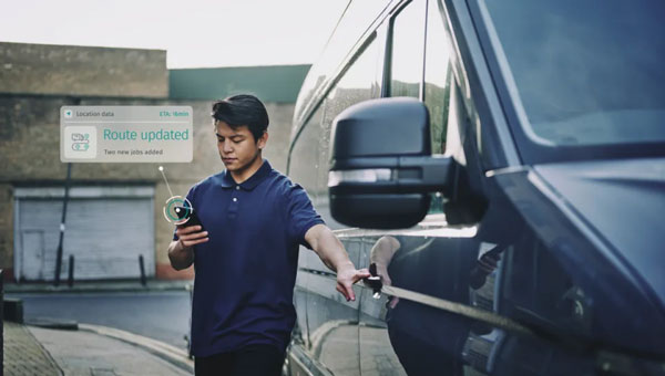
HERE Technologies has launched its Fleet Optimization software package, designed to enhance the efficiency and scalability of fleet management operations.
The Fleet Optimization package aims to meet the needs of the transportation and logistics industry. It offers location-based features using HERE’s artificial intelligence (AI) to tackle the complexities of routing operations for commercial fleets.
The package is a robust set of location-based application programming interfaces (APIs). The key components and features of the HERE Fleet Optimization package include:
HERE Tour Planning uses map content and complex routing scenarios that consider real-time and historical traffic, alongside vehicle and road restrictions, to provide optimal deployments of multi-vehicle commercial fleets.
HERE Routing creates optimized, safe and accurate navigation solutions customized to truck, light commercial vehicle and two-wheeler routing profiles.
HERE Geocoding and Search validates and enhances the accuracy of addresses and optimizes route planning through precise geocoordinates, ensuring fleet movements are based on the most accurate and current data available.
HERE Map Rendering offers up-to-date, detailed map data, in raster and vector formats, with rich attributes used specifically by commercial vehicles — including road restrictions, bridge heights, road topology and topography. This feature offers drivers visualization and cues for reliable commercial vehicle navigation.
A key benefit of the package is the incorporation of variables such as vehicle profiles, driver availability and delivery schedules, to provide instantly optimized tours and more precise estimated time of arrival (ETA).
The package is available for in-house software developers and integrated software vendors. The location-based APIs within the package are accessible directly in a user’s environment, with HERE offering the toolsets, workspaces and APIs for custom development.
The HERE Fleet Optimization package is built to run natively on Amazon Web Services (AWS), HERE Tour Planning and HERE Location Services, including Geocoding, Search, Maps, Navigation, Routing, Fleet Telematics and more.
HERE Technologies is collaborating with Amazon Web Services (AWS) to offer developers access to an array of location services through the recently launched AWS Serverless Application Repository.
Through the collaboration, HERE and AWS are increasing the speed and ease in which developers can access and integrate core location services into their applications.
Because HERE location services are available in the AWS Serverless Application Repository, developers can rapidly deploy AWS Lambda into their own AWS account that serve as proxies to HERE location services, and thus allows for a microservices approach to calling the HERE locations services. This approach also provides developers with benefits from Amazon API Gateway and AWS Lambda capabilities such as cache, throttling and authentication.
Developers on the AWS Serverless Application Repository have access to a suite of HERE location services, including:
map images and tiles
geocoding
positioning
routing
road toll costs
road traffic conditions
public transit information
weather conditions.
With credentials from developer.here.com, developers can access the location services on the AWS Serverless Application Repository, now available in Preview.
Hyper Precise Location (HPL), a real-time kinematics (RTK) service, is now available via Verizon ThingSpace to customers and application developers in more than 100 U.S. markets. When paired with Verizon’s 5G Edge capabilities, HPL provides precise positioning data for emerging cellular-vehicle-to-everything (C-V2X) technology, which is necessary for certain safety applications.
Verizon recently teamed with automakers to demonstrate vehicle-pedestrian safety scenarios made possible through HPL, 5G Edge and C-V2X.
HPL is software as a service (SaaS) that provides a stream of real-time GNSS correction data to device receivers, enabling location accuracy within 1-2 centimeters, for users on 5G and 4G networks. This can enable high-scale, low-cost, centimeter-level location capabilities for industries such as automotive, HD mapping, robotics, construction, and smart agriculture (AgriTech). Designed and deployed in a privacy-protective manner, HPL does not store or share user location data.
HPL embraces open delivery standards including RTCM for its data streams, with others to be added on a rolling basis. IoT devices using HPL can be accessed and managed through a user API and the ThingSpace IoT management platform. Support resources on ThingSpace will detail API integration, coverage availability, and more.
“Hyper Precise Location stands to boost or enable next-gen technologies across industries, from intelligent-driving to drone delivery to highly automated operations within construction, agriculture, and much more,” said TJ Fox, SVP of Industrial IoT and automotive for Verizon Business. “HPL’s fast expanding coverage area, API friendliness, privacy protection, and use of open-delivery standards make it ideal for developers and customers demanding precision and flexibility.”
In August, Verizon announced it is also developing HPL next-gen road safety and highly advanced driving solutions through partnerships with location and mapping expert HERE Technologies (HERE) and Renovo, the automotive software company. HPL can also support other emerging technologies that depend on high-level location accuracy, such as delivery drones, and advanced IoT applications, such as infrastructure monitoring, critical asset tracking, and high value shipping.
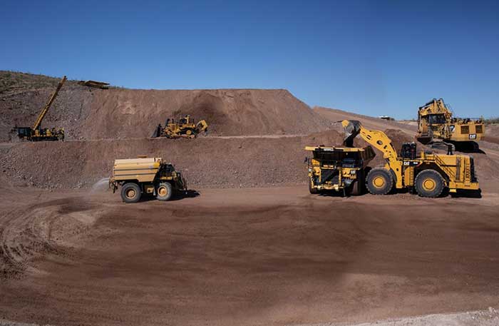
After years of testing and hype, not a lot of companies can say there are real applications for autonomous technology. However, at this year’s virtual CES 2021 trade show, both Caterpillar and John Deere, two companies known for their tractors and heavy equipment, showcased autonomous machines that are being used worldwide in farming and mining projects.
Photo: Caterpillar
Deerfield, Ill.-based Caterpillar, a first-time exhibitor at CES this year, said it has been involved in autonomy and use of GPS for more than two decades. “We were an early adopter of GPS when there were few satellites in the sky,” said Denise Johnson, company group president, resource industries. “We have 350 autonomous trucks operating 24-7 on three continents.”
The company’s autonomous vehicles, in addition to other technology, are being used around the clock in the Kearl Oil Sands project in Alberta, Canada.
“We are using autonomy primarily in mining operations in harsh environments. These [vehicles] are operating 24-7, with no loss time incidents,” said Bill Dears, Caterpillar worldwide sales and marketing manager. “We also track people underground with cameras and radar.”
In addition to production enhancement, safety is a factor in mining operations because of operator fatigue — something that is precluded by autonomous mining equipment, Dears said.
Agriculture uses variety of sensors, including GNSS
To Moline, Ill.-based John Deere, exhibiting at the trade show for the third time, agriculture is a high-tech industry that uses GPS, self-driving tractors, artificial intelligence and a multitude of sensors. The company rolled out its first self-driving tractors nearly 20 years ago, said Jahmy Hindman, John Deere CTO.
Photo: John Deere
The company won the CES Innovation Award for one of its tractor and combine product lines. “Both our planter and tractor have GPS and antennas to know where to drive and where exactly fertilizer [is to be placed],” Hindman said. “These tractors are self-propelled, with accuracy augmented with [real-time kinematic] sub-inch accuracy for the planters in a field.”
Among other requirements, Hindman said that tractors have to drive in a straight line, plant the required amount seeds and position them at the right depth. “When a tractor drives in a very straight line, the burden is off of the farmer. The yields increase—this is the way we see the progression of automation,” he said. “We are excited about 5G and its lower latency and high bandwidth. It opens up a lot of opportunity.”
Organizers roll out Indy Autonomous Challenge race car
At the virtual CES, representatives from the Indy Autonomous Challenge unveiled the Dallara IL-15 race car that will be used in a head-to-head race around the famous Indianapolis Motor Speedway on Oct. 23.
The Indy Autonomous Challenge, organized by Energy Systems Network and Indianapolis Motor Speedway, pits 500 university students, developing autonomous vehicle technology, against each other for a $1.5 million prize.
Logo: Indy Autonomous Challenge
Organizers say the speeds are estimated to be as much as 200 mph around the 2.5-mile track, for 20 laps, which enables researchers to evaluate how autonomous vehicle technology works in extreme conditions. They say that the goal of the race is to advance the implementation of autonomous vehicles and advanced driver-assistance systems (ADAS), much like the 2005 Defense Advanced Research Projects Agency (DARPA) Grand Challenge.
The race track has been the scene of much innovation throughout the years, said Doug Boles, Indianapolis Motor Speedway president. “Firestone tests tire technology there and that data transfers to our cars. One of the first conversations we had with Roger Penske [after Penske Entertainment bought the speedway] was about the autonomous challenge,” he said.
IAC sponsors include ADLINK, Ansys, Aptiv, AutonomouStuff, Bridgestone, CU-ICAR, Dallara, Indiana Economic Development Corp., Microsoft, New Eagle, PWR, RTI, Schaeffler and Valvoline.
Mobileye plans to test autonomous fleets in four cities
Intel subsidiary Mobileye plans to launch autonomous vehicle fleet testing in Detroit, Paris, Shanghai and Toyko. The announcement, made at CES by CEO Amnon Shashua, said that the company also plans to test in New York City, pending regulatory approval.
The company also plans to use in-house-built lidar sensors, while continuing to champion its camera-based testing. “We are using crowd-sourced data through the Cloud to build high-definition maps at scale,” Shashua said. “Thousands of product vehicles are sending us data.”
Shashua addressed a moderator’s question that cameras alone cannot be the technology of choice for autonomous vehicles. “The camera first is crucial from a technology and business point of view. We have to find out what is acceptable failure for Level 4 autonomy. Camera-only is ideal, but pushing the envelope for driver-assistance systems,” he said. “Consumer AV will take place in the 2025 timeframe. [Eventually], we can build lidar and radar to the same performance levels as camera systems. Lidar and radar can be added later for redundancy, but only for Level 4.”
Shashua said getting to Level 4 could take a decade, but that would be unsustainable unless there are government-funded projects to keep companies afloat. “By 2025, a subsystem will be good enough for consumers. Regulation is critical and sometimes it’s difficult to leap to a consumer level,” he said.
Not everyone believes what Mobileye is testing constitutes “driverless” status. To Alain Kornhauser Princeton University professor and transportation program director, who was head of the university’s team during the 2005 DARPA Challenge, not many companies are capable of full driverless capability.
“Unfortunately, I still see all of this as simply ‘eye candy’ to sell something that actually has no intention of delivering what it is implying. I still claim that the business case is zero, doesn’t exist, for personally-owned autonomous vehicles,” Kornhauser said in his Smart Driving Cars weekly newsletter. “Mobileye is nowhere close to being able to operate safely on most roads, let alone all roads. Thus, the consumer market has zero opportunity to scale.”
Kornhauser said that driverless testing is being conducted only in one place, Phoenix, by Waymo. “Neither Tesla nor Mobileye are driverless anywhere. They both require on-board human driver supervision,” he said. “That’s why they are only self-driving [tests].”
In other CES news:
GM CEO Mary Barra unveiled a single-seat electric vertical takeoff and landing (eVTOL) concept aircraft. The aircraft will be developed for future use as an air taxi. Barra briefly mentioned that the company’s Super Cruise self-driving technology will be integrated into 22 car models in a few years. The company also rolled out an electric vehicle for deliveries that can travel 250 miles on a charge and a motorized pallet for deliveries that can be tracked.
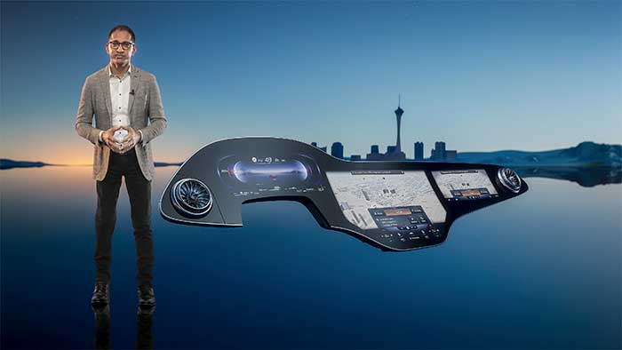
Photo: Mercedes-Benz
The Mercedes-Benz’ MBUX Hyperscreen, rolled out at CES, evaluates map data, surroundings and provides information about landmarks along a route, said Sajjad Khan, company CTO and member of the board of management. The new map feature, called Mercedes Travel Knowledge, allows a passenger or driver to ask a question as they drive by a landmark (“hey, Mercedes, what can you tell me about this building?”). The MBUX Hyperscreen is available in the new S-Class cars.
HERE Technologies introduced a mapping-as-a-service platform at CES. The platform is targeted to businesses wanting to create custom map datasets for advanced analytics and services, the company said. Some use cases include industrial yard mapping, leveraging probe data from private vehicle fleets in order to create or update a map.• A virtual CES is hard to get used to. After more than 20 years of covering the massive trade show in person, covering press conferences and conducting interviews online was sometimes a challenge. Sometimes the press conferences did not have question-and-answer sessions, or canned answers given to executives by public relations people. This doesn’t happen much during an in-person interview. In addition, trying to chat with “booth” personnel online was cumbersome and often those requests for information were ignored.
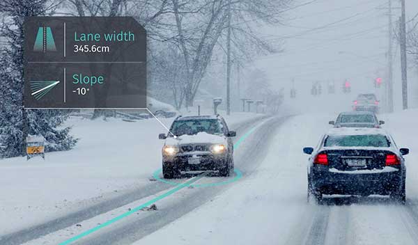
Drivers will now be able to enter what3words addresses directly into their in-car systems, allowing them to navigate to any destination
Image: HERE
HERE and what3words have partnered up to offer the next generation of precision in-car navigation. OEMs using HERE Technologies can now include what3words as an in-car navigation feature, with drivers of enabled vehicles able to navigate to any precise 3-meter square using a what3words address.
HERE is the world’s leading navigation platform with its map data services found in 150 million vehicles worldwide. The platform offers products designed to use the latest location content, such as road networks, buildings and traffic systems. The addition of what3words address entry means that drivers can experience the smartest mapping systems, alongside the break-through address system.
what3words is an innovative addressing system which has divided the world into a grid of 3-meter squares and given each square a unique combination of three words: a what3words address. For example, HERE’s Chicago office can be found at ///memory.traps.lease. what3words enables people to easily convey locations as specific as building entrances or parking spots and it provides easy location references in places with no street addresses, such as beaches, parks and remote hiking trails.
Drivers can input a what3words address directly into their car head unit or connected car app, just as they would a street address or point of interest. Millions of what3words addresses are being used over the world, with drivers finding them in booking confirmations, guidebooks, website contact pages or in messages sent by friends.
Drivers can also discover what3words addresses on the free what3words app or the online map. what3words’ technology has been adopted by global car companies, logistics providers and mobility apps, including Mercedes-Benz, Tata Motors, DB Schenker, Hermes and Cabify.
“HERE is the richest, most accurate and freshest mapping system on the market and it now comes with the easiest way to communicate a location,” Chris Sheldrick, CEO and co-founder of what3words said. “Using a traditional address in a vehicle can be a bad experience. They are clunky and lengthy to type, and even a voice assistant will often mishear you. Once the address is accepted, it won’t take you to a precise location, such as the specific entrance you need, it’ll route you to where the pin drops — which is often the centre of the building.
By using what3words, drivers need simply to enter three words and know they will arrive at that precise 3-metre square. We are seeing increasing demand from automakers and mobility services. Now that we are embedded in HERE, we can enable our address system simply and easily in both new and legacy vehicles.”
“Our partnership with what3words is a solid example of how HERE continues to innovate in the area of navigation,” said Jørgen Behrens, senior vice president and chief product officer at HERE Technologies. “Automotive OEMs and Tier 1 suppliers can now provide the what3words service to their customers with the help of HERE Professional Services instead of having to integrate it themselves. This will allow drivers to navigate easily in dense, urban environments with non-standard addressing schemes or seamlessly get to any location, be it a local pub or a trailhead.”
Incorporating this new feature is easily done for both new and existing clients, with what3words available as an add-on to HERE’s core navigation products.
Using RTK’s pinpoint-level location data in the Verizon network is a building block to bring to scale emerging technologies such as driverless city zones, expansion of precision agriculture and drone delivery.
Verizon has launched what it calls hyper-precise location using real-time kinematics (RTK) to provide accuracy within one to two centimeters on the Verizon network.
Verizon has built and deployed RTK reference stations nationwide so that compatible internet of things (IoT) devices can receive the higher accuracy. Verizon is working to make RTK accessible with myriad device makers.
RTK will also support emerging technologies that depend on high-level location accuracy, such as delivery drones and customer-approved location data for first responders in emergencies.
RTK technology reduces the cost and risk associated with inaccurate location data, Verizon said in a press release. “Billions of IoT devices across a multitude of industries will benefit from improved location accuracy, with hyper-precise location information enabling a host of new services.
“For instance, robotics at distribution centers will be able to perform more efficient, accurate and safe logistics operations. More accurate positioning can help speed deployment of high-value assets in emergency situations to the precise location, and more precise tracking of emergency equipment can provide faster redeployment in disaster response scenarios.”
The rollout of its hyper-precise location services along with Verizon’s 5G Ultra Wideband network and 5G Edge will pave the way for more autonomous technologies, the company said.
“We are scaling RTK to enable mobile location accuracy to within a few centimeters, transforming what is currently possible when it comes to location-enabled services and new IoT solutions coming onto the market,” said Nicola Palmer, chief product development officer for Verizon. “Continued growth in the IoT environment means billions of devices in fields where precision location services are becoming more critical, such as vehicle automation, unmanned aerial vehicles, precision agriculture technology, infrastructure monitoring, asset tracking and high-value shipping.”
Image: 4X-image iStock / Getty Images Plus / Getty Images
Reimagining road safety
In partnership with HERE Technologies, Verizon is building next-generation technologies for vehicle and pedestrian safety using hyper-precise high-definition mapping and RTK.
This work paves the way for connected services that are designed to drive road safety improvements. By creating a vehicle-to-network (V2N) communication system equipped with hyper-local location accuracy, collision avoidance applications can precisely identify vehicles, pedestrians and bicycles, and relay the information through Verizon’s 5G Edge and HERE’s AI to predict likely travel paths and warn vehicles of impending potential collisions. This partnership is one of multiple recent initiatives Verizon has taken to increase road safety.
“Moving beyond the static fidelity of satellite-based location data enables an exciting new generation of connected, autonomous experiences,” said Jørgen Behrens, SVP, chief product officer at HERE Technologies. “By pairing HERE’s live, hyper-precise HD Map and HD Positioning technologies with intelligent RTK algorithms, and making that scalable, Verizon is putting a transformative level of location insights into the hands of developers and consumers alike.”
Powering the autonomous future
Hyper-precise location accuracy will be critical to advancing autonomous driving and together, Verizon and Renovo are ushering in a new era of transformative solutions critical for the future of autonomy on the road. These solutions leverage machine learning and RTK technology, powered by a combination of next-generation solutions such as 5G.
“RTK is a critical technology for advanced driving assistance systems (ADAS). Accurate positioning helps ADAS vehicles navigate better, drive smoother, and react faster to the surrounding environment,” said Christopher Heiser, CEO and Co-Founder of Renovo. “Nationwide, reliable RTK networks make for a viable way to deliver these enhanced capabilities to mass-market cars and trucks. For companies that manage the huge datasets that power next-generation vehicle platforms like Renovo, this is very exciting.”
IoT devices currently using RTK can be accessed and managed through Verizon’s ThingSpace management platform and APIs.
San Francisco, captured by HERE’s 3D mapping technology. (Image: HERE)
In 1854, English physician John Snow mapped the London cholera epidemic to determine the exact location of a contaminated water pump on Broad Street, pioneering the use of location mapping and data to manage public health crises.
Today, governments and public health officials are utilizing location data to help fight the COVID-19 global pandemic. Location data and maps are at the frontlines to aid emergency responders and healthcare providers, while GIS professionals, data scientists and many others rely on maps and location data to allocate supplies, manpower and assets where they are needed most.
Data as a source of truth
Location data has been one of the most valuable tools to guide crisis response. By referencing professionally managed, comprehensive geospatial databases, public health officials are able to precisely locate key medical and emergency resources, including hospitals, medical centers, medical and emergency services, pharmacies, and food and water distribution centers.
For example, the HERE location platform continually validates the freshness and features of its map through thousands of data sources. This includes field-collected data, third-party data from government sources, and crowdsourced data from expert communities. Taken together, the process rapidly delivers clear, timely location information to end-users such as key medical stakeholders.
It is critical that all levels of government — local, state and federal — have access to these types of valuable datasets during times of emergency. In response to the pandemic, we have seen incredible agility from facilities that have been converted to provide critical medical services.
For example, the Javits Center in New York City has been used as a field hospital, a sports facility has been converted into a drive-through testing center, and schools are being used to distribute food. By tracking these updates, authorities have real-time awareness of these facilities and their availability to provide services.
Use Case #1
Social distancing efficacy
At this stage of the pandemic, the Federal Emergency Management Agency has tapped into location data to track the efficacy of social distancing policies and the spread of the virus. It’s valuable to map the virus’s spread for many reasons, but a few key reasons include:
Predicting the movement of COVID-19. By mapping the spread, we can proactively align the medical supply chain behind these predictions.
Understanding the effectiveness of social distancing. Social distancing is one of the most powerful ways to stop the spread of the virus. By tracking the efficacy of these measures and regulations and ensuring that citizens are complying with shelter in place, we’re able to predict how we are able to slow or flatten the spread.
Predicting the economic impact. As we consider reopening America for business, it’s important to understand where the virus is most prevalent, and the timeline for recovery.
Use Case #2
The strained medical supply chain
The coronavirus has caused strain across most industry supply chains, but most notably, the medical supply chain. Medical resources, including hospital beds, masks and life-saving ventilators have become scarce and unevenly distributed.
In times of crisis, with thousands of lives at stake and the potential for further economic fallout, it’s critical that public health officials are equipped with authoritative, comprehensive datasets to guide decision-making. When organizations are equipped with this valuable data, they can harness the power of location data for good and follow in the footsteps of the location data pioneer John Snow.
A roundup of recent products in the GNSS and inertial positioning industry from the March 2020 issue of GPS World magazine.
OEM
NavIC modules
Support both L1 and L5 bands
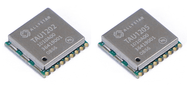
Photo: Allystar
The dual-band multi-GNSS modules TAU1202 and TAU1205 support both the L1 and L5 bands to enhance sub-meter positioning accuracy. Constellations received include GPS, Galileo, GLONASS, BeiDou, QZSS and NavIC. Besides the L1 band, TAU1202 and TAU1205 also support L5/B2a/E5a, which are expected to have lower noise and significantly reduced multipath mitigation because of the higher chipping rate of L5 signals relative to L1 C/A code. TAU1205 supports NavIC (IRNSS), improving navigation in India and the Middle East. Powered by the Cynosure III GNSS chipset and with built-in low-noise amplifier and surface acoustic wave (SAW) filter, TAU1202 and TAU1205 provide higher sensitivity, ensuring exceptional acquisition and tracking performance even in weak signal areas.
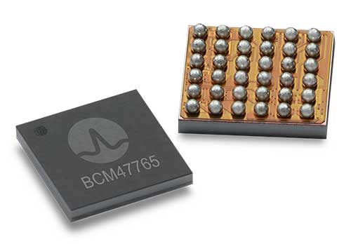
The BCM47765 dual-frequency GNSS module is capable of using the BeiDou-3 constellation’s B2a signals (the Chinese indicator for L5). It can track 30 new L5 signals (60% more) with a significant impact on accuracy. End users will experience much higher reliability of the submeter accuracy inherent to dual-frequency L1/L5. The enhanced L5 signal improves the accuracy of GNSS in an urban scenario by mitigating reflections from nearby buildings (multipath). It also improves GNSS in an open-sky scenario, allowing for submeter accuracy. Second generation dual-frequency GNSS will enable lane-level driving navigation, allowing applications to know in which highway lane a vehicle travels.
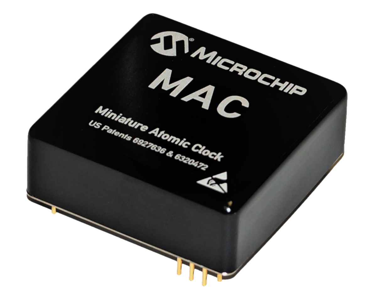
The MAC-SA5X miniaturized rubidium atomic clock is a high-performance atomic clock that delivers a wide thermal range, critical performance improvements and other enhancements over previous clocks. The MAC-SA5X produces a stable time and frequency reference that maintains a high degree of synchronization to a reference clock, such as a GNSS-derived signal. Its low monthly drift rate, short-term stability and stability during temperature changes allows the device to maintain precise frequency and timing during extended periods of holdover during GNSS outages or for applications where large rack-mounted clocks are not possible. Operating over a temperature range of –40 to +75 Celsius, the MAC-SA5X is designed to quickly achieve atomic stability performance with a fast lock.
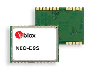
The NEO-D9S GNSS correction data receiver module provides an affordable approach to bringing centimeter-level accuracy to GNSS receivers. The NEO-D9S receives corrections from correction service providers broadcast on the L-band (1525–1559 MHz). A host processor can then decrypt this correction data and provide it to a high-precision GNSS receiver, combining corrections directly with readings from the satellite constellations to enable much more accurate position readings than those offered by GNSS signals alone. Use of the NEO-D9S will also increase the availability of high-precision GNSS positioning data in areas with limited connectivity and reduce the amount of cellular data consumed by positioning receivers. Expected customers are Tier 1 and OEM carmakers, industrial system integrators, and any other applications that rely on very accurate positioning at low cost. The NEO-D9S module is a correction-only receiver. Based on the latest u-blox ninth-generation (D9) platform, it will integrate easily with the u-blox F9 RTK GNSS receivers from u-blox, or can be used as part of a modular product roadmap.
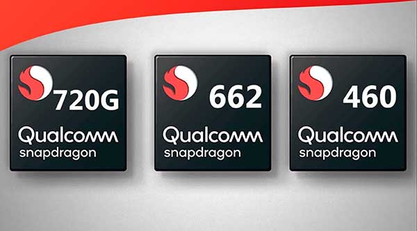
The Qualcomm Snapdragon 720G, 662 and 460 enable enhanced user experiences across connectivity, gaming and entertainment. The new mobile platforms support dual-frequency (L1 and L5) GNSS to improve location positioning accuracy and robustness. The system-on-chip solutions also support NavIC. For the first time on mobile, the Qualcomm Location Suite supports up to seven satellite constellations concurrently, including NavIC.
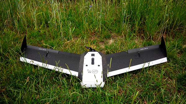
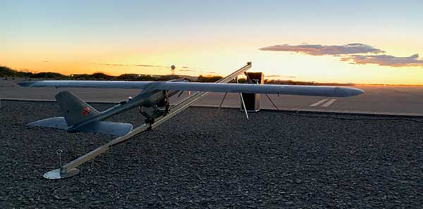
Dedicated to surveying and agriculture, the UAV Birdie is tailor-made, combining intuitive use and high-quality data through precise sensors and GPS RTK L1/L2 onboard. Features include a 24-megapixel camera or optional full-frame 42-megapixel camera; flight time up to 60 minutes; and coverage up to 8 square kilometers in one flight. A vertical-takeoff-and-landing (VTOL) upgrade is available.
Skyfront’s Perimeter 8 drone is equipped with Silvus Technologies’ SteamCaster Radio system, a powerful user-customizable radio system for the military, police and broadcast. The new long-range drone will allow operators to inspect pipelines and other assets as well as conduct long-range surveillance missions. The octocopter can fly for five hours and travel up to 100 kilometers without losing connection from the ground station. Currently, five models are available to suit uses including mapping, lidar and medium, long, or extra-long surveillance. SteamCaster radio system uses the latest beam-forming technology, spatial multiplexing, and space-time coding to ensure the drone can be controlled in environments in which other radio systems are likely to fail. The combination of the technologies allows the range to be increased from 40% to 100%. SteamCaster comes with SteamScape, a network management interface to allow for key metrics and statistics to be viewed and collected in real time. The system also allows the drone to be overlayed onto a map showing the current location and path of the drone.
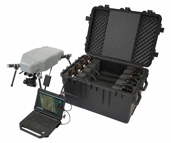
Delivers critical tools on the ground or in the air
Photo: Robotic Research
The Pegasus Mini is a smaller version of the Pegasus, a hybrid unmanned aircraft system/unmanned ground vehicle. The Pegasus hybrid UAS/UGV configuration delivers advanced GPS-denied mapping with fully autonomous high-speed flying and driving capabilities. Pegasus Mini is designed to provide the extra reach that a UAV or UGV alone cannot provide. Uses include inspection, rescue, rapid response, and applications that strongly benefit organizations in oil and gas, public transportation, law enforcement, public safety, and more.
The Silent Falcon E1 UAV has completed 500 hours of successful flight testing and operations. It’s maker, Silent Falcon UAS Technologies (SFUAS), is based in Albuquerque, New Mexico. The E1 solar-electric, fixed-wing UAV is noise free, emission free, and provides long-range, low-cost intelligence, surveillance and reconnaissance (ISR) capability. It has a payload capacity of 20 pounds and a ceiling of 20,000 feet above ground level. SFUAS has an application pending before the FAA for type certification of the E1. The 500-hour milestone confirms for federal regulators that it is safe and durable. Silent Falcon aircraft have operated in eight foreign countries and are not ITAR restricted.
The High Definition (HD) GNSS cloud-based solution enables mass-market devices to achieve sub-meter accuracy across the globe. HD GNSS enables lane-level navigation, augmented reality and virtual reality. It combines precise point positioning (PPP) and real-time kinematic (RTK) positioning methods, allowing for fast convergence time, high availability and global coverage. It also supports off-the-shelf mobile devices and internet of things (IoT) trackers equipped with dual-frequency chipsets.
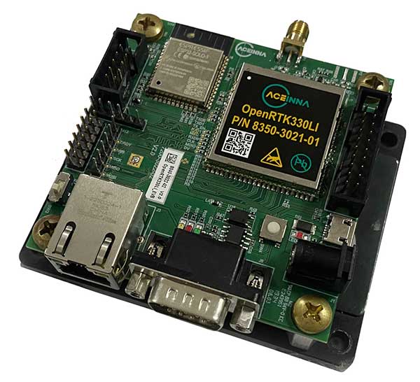
The OpenRTK330L GNSS/INS module is designed for developers creating guidance and navigation systems for autonomous vehicles, robots, drones, industrial, construction and agricultural machinery. OpenRTK330L is a low-cost, high-performance triple-band RTK/GNSS receiver coupled with redundant inertial sensor arrays to provide cm-level accuracy, enhanced reliability, and superior performance during GNSS outages. The module is aimed at automotive, robot, drone, construction and agriculture systems. The multi-band GNSS receiver can monitor all global constellations (GPS, GLONASS, BeiDou, Galileo, QZSS, NavIC, SBAS) and simultaneously track up to 80 channels. The module has RF and baseband support for the L1, L2 and L5 GPS bands and their international constellation signal equivalents.
HERE Technologies and Altair Semiconductor are partnering to integrate HERE tracking and positioning software into Altair’s ALT1250 dual-mode LTE Cat-M1/NB-IoT chipset. This will enable HERE customers, system integrators and tracking device manufacturers to significantly reduce device time to market and provide hardware-based security.
The two companies plan to reduce overall power consumption of an end-to-end tracker application by optimizing the way the device communicates with the cloud.
The ALT1250 includes a GNSS receiver, an RF front-end supporting all commercial LTE bands within a single hardware design, a hardware-based security framework and an internal application MCU subsystem.
The integration of HERE tracking and positioning software means the chipset will be able to locate itself using the strength of cellular signals, even when it is not possible to obtain a GNSS fix.
The chipset can take advantage of the ability of HERE to provide online and offline positioning based on its database of cellular towers.