Tag: Iceland

  • Baltic and North Sea states warn of safety risks from GNSS interference

    Baltic and North Sea states warn of safety risks from GNSS interference

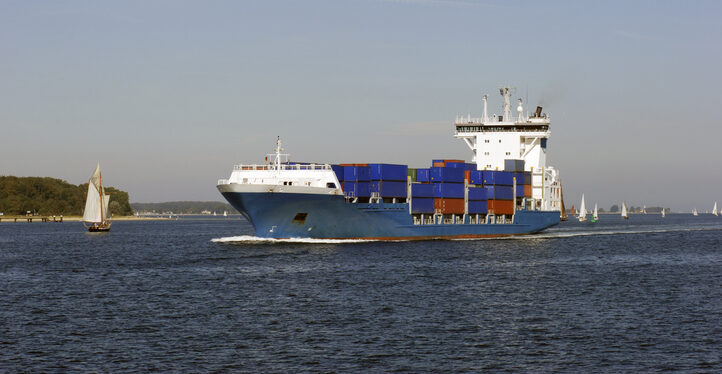
    The Coastal States of the Baltic Sea and the North Sea have published an open letter to the international maritime community insisting on the protection of GNSS-based navigtion. The countries point the finger squarely at the Russian Federation for causing disruption in both critical navigation and timing services for sea vessels.

    “Modern maritime transport is fundamentally built on the reliability of satellite-based navigation,” reads the letter. “For over three decades, global shipping has advanced by developing vessel operations to increasingly depend on the position, timing and navigation data provided by satellite systems. This shift has brought great efficiency but has also created a new dependency.

    The letter highlights the importance of GNSS as a critical safety requirement, not only ship navigation but also precise time synchronization vital for systems such as the Global Maritime Distress and Safety System (GMDSS).

    Risks to the Automatic Identification System

    Another GNSS service, the Automatic Identification System (AIS), plays a key role in traffic coordination, situational awareness and emergency response. “Spoofing or falsifying AIS data undermines maritime safety and security, increases the risk of accidents, and severely hampers rescue operations,” the letter states.

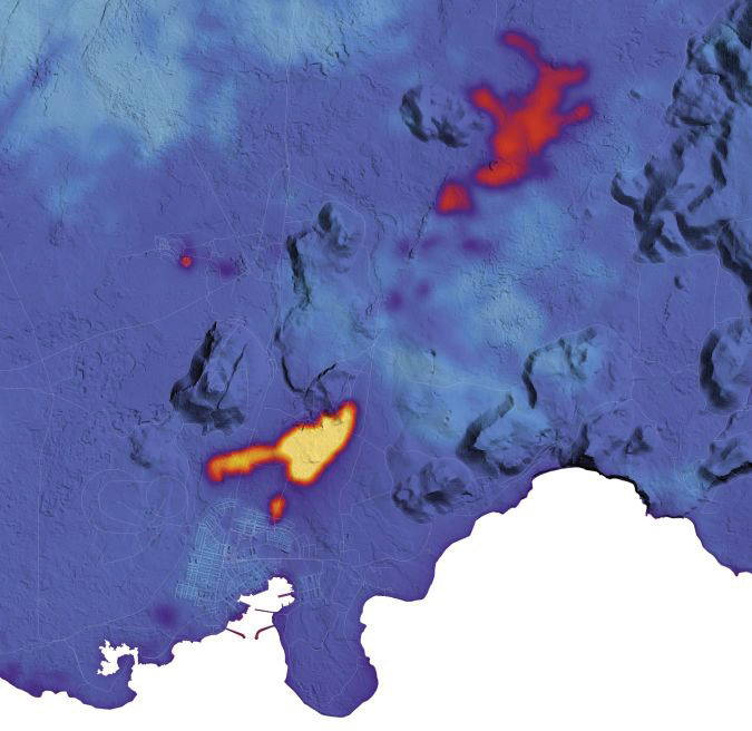
    “We are now facing new emerging safety situations due to growing GNSS interference in European waters, particularly in the Baltic Sea region. These disturbances, originating from the Russian Federation, degrade the safety of international shipping. All vessels are at risk.”

    The countries ask for cooperation developing alternative terrestrial radionavigation systems as a GNSS backup. They also want vessels crews properly trained to operate safely during navigation system outages.

    “Maintaining trust in maritime navigation requires more than technology – it demands responsibility, transparency, and decisive action,” the letter states. “We must ensure that our seas remain safe, including when systems fail or face disturbances.”

    The signatories include:

    • Belgium
    • Denmark
    • Estonia
    • Finland
    • France
    • Germany
    • Iceland
    • Latvia
    • Lithuania
    • The Netherlands
    • Norway
    • Poland
    • Sweden
    • The United Kingdom
  • Mapping the aftermath of Iceland’s volcanic eruptions

    Mapping the aftermath of Iceland’s volcanic eruptions

    The Icelandic Road and Coastal Administration (IRCA) has commissioned the Dutch UAV manufacturer Acecore to map the extent and aftermath of the Eldvörp-Svartsengi volcanic system eruption using its high-end UAV solutions. Grindavík, a fishing village on the Reykjanes Peninsula in southwestern Iceland, has only recently welcomed residents home following a series of earthquakes. However, the area is still not completely at ease, with the latest reports saying that a nearby magma chamber could again erupt near the village.

    Acecore’s new hybrid drone model. (Photo: Acecore)
    Acecore’s new hybrid drone model. (Photo: Acecore)

    “Acecore drones are particularly suitable for use under tough circumstances,” said Jorrit Linders, founder and CEO of Acecore, on the Dutch public-service radio station NPO Radio 1. “The drones can operate in severe weather conditions, such as wind force 7 or 8, temperatures well below zero and hail and snow showers. This is due to their robust frame, their strong design and the right components. The robust construction is produced entirely in the Netherlands. This, combined with a continuous flight time of 2.5 hours, is essential for projects such as the volcanic eruption in Iceland.”

    Acecore has been mapping in the region near Grindavík for four weeks as of March 2024. The surveys were done not without challenges and risks, as they involved operating in areas that had not yet been declared safe. The high workload and poor weather conditions forced the on-site team to rotate every five to six days. Linders was able to train both Acecore employees and pilots working for The Icelandic authorities on how to properly conduct aerial surveys to collect the relevant data effectively.

    Lava flowing down the main road toward Grindavík. (Photo: Acecore)
    Lava flowing down the main road toward Grindavík. (Photo: Acecore)

    Acecore developed and deployed a hybrid version of its Noa UAV, which already was used by the Icelandic authorities. The gas-electric platform was able to achieve flight times of 132 minutes with the Radarteam Cobra ground penetrating radar (GPR) of 5.2kg. The Noa Hybrid UAV has liquid heat management for its gasoline boxer engine, making it highly capable of dealing with Icelandic temperatures of up to -12°C. It uses a dual antenna and dual-band GNSS high-precision receiver to accurately measure yaw using GPS, so as not to be affected by electromagnetic interference from power lines and metal structures while mapping the village.

    This map indicates the location and extent of recent activity using data acquired on January 16, 2024, by the TIRS-2 (Thermal Infrared Sensor 2) on the Landsat 9 satellite. The data is overlaid on a digital elevation model of the area. (Photo: NASA Earth Observatory/Lauren Dauphin, contains Landsat data from the USGS)
    This map indicates the location and extent of recent activity using data acquired on January 16, 2024, by the TIRS-2 (Thermal Infrared Sensor 2) on the Landsat 9 satellite. The data is overlaid on a digital elevation model of the area. (Photo: NASA Earth Observatory/Lauren Dauphin, contains Landsat data from the USGS)

    The UAV flights take off from fixed locations to perform their automated missions: scanning the affected area to collect all data needed by the Icelandic authorities. This involves data generated by a GPR sensor mounted under the UAV.

    “We take a kind of X-ray of the ground as the basis for accurately mapping the subsidence and cracks,” explained Linders. “This then allows the Icelandic scientists to do a careful analysis of the area.” The GPR technology allows cracks to be scanned and underground fissures and shifts to be identified so scientists can predict where more eruptions are likely to occur and assess the safety of the location.”

    The GPR technology allows cracks to be scanned and underground fissures and shifts to be identified so scientists can predict where more eruptions are likely to occur and assess the safety of the location.

    The ongoing efforts in Iceland are a testament to Acecore Technologies’ dedication to pushing the boundaries of what is possible with UAVs. As they continue to map the area around Grindavik, their expertise and technology are not just tools for assessment but also a sign of hope for a community looking toward recovery. There is more work to be done, said Acecore’s Youri van Helden, “We haven’t put our snow boots in storage yet.”

  • Winners announced from myEUspace competition

    Winners announced from myEUspace competition

    Image: EUSPA website
    Image: EUSPA website

    The European Union Agency for the Space Programme (EUSPA) has announced the winners of the first myEUspace track “Submission of an Idea.” This track consists of promising theoretical ideas that leverage EU space data and have high market potential. Winners received a cash prize of €10,000 each.

    The myEUspace competition is open to teams from all EU Member States plus Switzerland, Norway and Iceland. The competition offers a total prize of nearly €1 million and provides support to entrepreneurs throughout the entire innovation cycle, from early-stage start-ups to scale-ups.

    While the evaluation of the prototypes track is ongoing, the competition remains open for the last track, “Submission of Products.” Applications for the final track are due April 25.

    Depending on the maturity of the solution at the time of submission, entrepreneurs can compete and win in three different innovation areas: “Space My Life,” “Our Green Planet” and “Dive in Deep Tech.”

    See the full list of winners by area of innovation:

    “Our Green Planet”
    • Spillalert: Intuitive web interface for oil spills and blackwater tank detection
    • BugBit: Risk analysis platform for predicting and alerting of bark beetle outbreaks
    • Push4CleanAir: SaaS pollution monitoring platform
    • Detritus: Online platform and mobile app for waste-crime detection
    • Orioos: Autonomous robotic solution for monitoring woody perennial crops
    • Vantu: Van-lifers companion app to discover “off the beaten track” sites to camp for the night

    “Dive in Deep Tech”
    • DeGenS: Decentralized space-to-ground data availability for artificial intelligence (AI) using blockchain
    • Climate AI for Web3: Real-world portable climate API for virtual worlds powered by AI and satellite data
    • Latitudo Supersar: AI analysis, classification and interpretation of multi-sensor and multi-mission images
    • WhisperCash: Person to person payments via satellite for isolated regions
    • Kyck: Geospatial metaverse platform for exploring and sharing AR experiences in the physical world

    “Space My Life”
    • Foremca: Cryptographic methodology providing forensic digital proof
    • MicroPURA: Microbial Purity to detect levels of microbial contamination in the air
    • Space4CC: Monitoring actions to safeguard cultural heritage in conflict areas
    • Oasis City Lab: AI tool to track urban threats