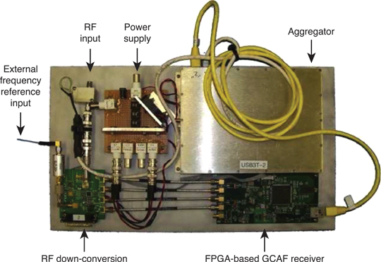
Gladiator Technologies’ low-noise inertial sensor and systems technology coupled with Velox high-speed processing are now integrated with a 72-channel GNSS receiver to provide compact GNSS/inertial navigation systems (INS) for accurate position, velocity and attitude.
The feature set was carefully selected to suit several positioning, navigation and timing (PNT) applications including flight control, navigation and stabilization for imaging, platforms and antennas.
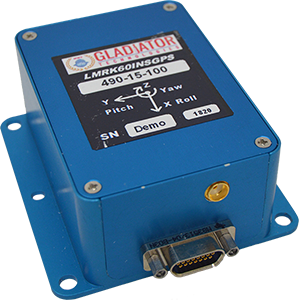
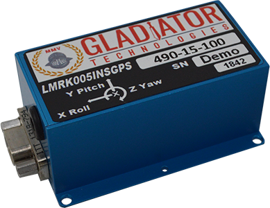
The high-performance LandMark 60 INS/GPS and compact LandMark 005 INS/GPS both feature advanced sensor-fusion technology, combining GNSS position data with Gladiator Technologies’ low-noise, high output inertial sensors as well as barometric pressure and magnetometers.
Both products feature Gladiator Technologies’ proprietary Velox processing technology and extended Kalman filter (EKF), enabling precision position information during short-term GPS outages.
Velox Technology combined with the new EKF enable the LandMark INS/GPS products to have accuracy of less than 2 nautical miles per hour during short-term GPS outages.
The LandMark 60 INS/GPS is the top performing unit with +/- 0.3° heading accuracy and pitch/roll angle measurements of 0.1°. It is also available with an option for a real-time kinematic (RTK) GPS receiver.
The small and robust LandMark 005 INS/GPS is less than 35 square centimeters and is suitable for space-constrained applications that require a high standard of INS/GPS performance.
“Our low-noise sensor inputs to the EKF are enhanced by an adaptive estimation algorithm,” said Lee Dunbar, chief software architect. “This, along with extended precision for the nonlinear solution integrator, maximizes the accuracy of position, velocity and attitude. Customer configurable EKF parameters are present to allow optimization for their applications.”
“Leveraging our inertial capability into a complete INS/GPS package was a natural progression for our product line,” said Eric Yates, Gladiator Technologies’ new business development manager. “With the LandMark 005 INS/GPS and LandMark 60 INS/GPS we’re offering an exceptional MEMS-based INS/GPS that fits in the palm of your hand.”
For an industry that makes its living identifying people and objects at a particular point in space, the geolocation industry — made up of applications providers, mapping companies and device manufacturers — has been very slow to make the move from two dimensions (2D) to three dimensions (3D). There is no excuse for this, as the ability to locate in 3D is fully tested and operable. What explains the holdup and what is being done to meet the growing need for 3D solutions?
Industry participants recognize the inevitable move towards 3D but give four main reasons for the delay:
There is a lack of awareness about some of the robust, scalable solutions that are available for deployment today
Businesses continue to make money from 2D applications
The investment required for 3D applications is too high
The eco-system for 3D applications is not fully developed
It seems that applications using location data simply rely on whatever information is made available through devices, mostly driven by GPS. There are more specific location technologies that offer fully tested, citywide vertical location solutions.
Despite years of deployments and generating effective use cases in two dimensions, the industry must do a better job of keeping up with technology advancements, especially those most likely to benefit from 3D location, and articles like this help!
But why is there a lag in the industry to move to a 3D world?
2D complacency
The explanation for the lag in moving to 3D is that the geolocation industry is still making money from 2D applications and, as the old saying goes, “If it’s not broken don’t fix it.”
While it’s true that many non-mission critical applications are getting along fine using 2D and will for the foreseeable future, the need for 3D is now. At a basic level, traffic directions don’t really require a 3D layout of the topography of your daily commute, although I could argue the traffic use case would benefit from knowing whether traffic on a map is on an overpass or ground level roadway. Certainly rideshare companies could benefit from communicating to their customers what level in a parking garage or airport they are on.
Other use cases are demanding more sophisticated 3D technology. One of the initial drivers for high-accuracy 3D (and indoor) location has been the needs of the public safety community. When lives are at stake, first responders require the most specific possible location accuracy in order to quickly find emergency callers and others needing help.
Beginning in April 2021, Emergency Communications Centers (911 call centers) will receive vertical location of emergency callers from wireless carriers. Computer-aided dispatch (CAD) systems are exploring how best to incorporate this information and direct first responders to the 911 caller’s 3D or floor-level location.
The benefit is obvious, as emergency callers cannot always provide their exact location to the 911 operator, so technology fills the gap. Other industries ranging from mining to healthcare to enterprise security similarly are also demonstrating demand for 3D applications, and we are seeing moves to meet this demand, but there is a long way to go.
High stakes
Another reason for the relatively slow development of 3D applications is the investment required. Even with a demonstrable demand across several industries, many players in the geospatial industry aren’t willing to invest funds to pioneer new solutions.
For every big player like Samsung or Apple, who have committed to developing state-of-the-art 3D sensors in their devices, there are many small players who must instead follow the market and adopt white-label solutions that don’t require as much upfront investment.
While it’s true that some 3D technologies can require significant investment and a committed strategy on the part of geospatial industry players, locating devices in 3D is possible today and there is a huge potential to serve new markets and improve business and consumer applications.
The 3D eco-system
As the market for commercial applications reaches a tipping point where 3D is not just a curiosity but is becoming a must-have for many consumers and businesses, the industry ecosystem must step up and deliver all parts of the solution. The mapping industry presents an interesting use case in this regard.
Digital maps have been in use for years, since the advent of the first fleet tracking devices in the 1980s, which led to the widespread use of consumer car tracking systems, and then onto Waze and other Smartphone-based mapping applications. Even these maps, which are huge advancements over their predecessors, do not fully reflect the 3D world we live in, and generally do not include accurate maps of the indoor environments in which we spend most of our time.
The next step in mapping is the digitization of entire buildings and other structures to create accurate 3D representations. However, even pioneers in this space aren’t fully utilizing 3D technology throughout their product roadmap, and, until there is a fully developed 3D ecosystem, it’s difficult for a company to go ahead alone.
As one leading company explained to us, without a consistent protocol for the use of 3D data and its conversion into 3D maps, they can’t justify converting their entire production from 2D, so they instead create 3D maps as one-offs where needed. They haven’t yet seen the critical mass in the industry required to go full 3D, and they are still working with, and making money from, 2D partners.
They are preparing for the time when the industry is fully 3D, which they believe will come soon.
A 3D world
Stepping back and taking a broader view of where we are, I think we are witnessing an industry in transition. With the deployment of city-wide, scalable location solutions that incorporate location data from a variety of sources, the initial building blocks are in place for the move to a fully 3D world.
Pioneering companies are going after growing demand (and in some cases creating that demand), even with limited resources, and seeding an ecosystem for others to build upon. I would in fact challenge the industry to produce a use case that would not benefit from improved location and 3D awareness — from the daily commute through complex freeway systems to shoppers navigating a multi-story mall to find a specific retailer, to protecting workers running large hotels, and more, the applications are endless and promise to multiply as users realize the benefits of 3D technology.
It is only a matter of time until the location industry will fully embrace the fact that the world indeed is not flat.
About Matt Rothschild
Matt Rothschild
Matt Rothschild is the Mountain View-based Head of 3D Location Customer Engagement for Polaris Wireless. He is a wireless and telecommunications industry leader with more than 20 years’ experience leading sales, marketing, product and operations organizations internationally. Rothschild successfully led sales and marketing teams for Nokia in Asia (Singapore), the Middle East & Africa (Dubai) and the Americas (Miami/Silicon Valley). Most recently, Rothschild led the Nokia/Microsoft acquisition and integration for North America, building partnerships with key mobile operators and channel partners, as well as building important ecosystem and developer relationships for the Windows platform.
Streaming 3D geospatial technology company Cesium will support the Smithsonian Institution by streaming 3D models of massive objects in its collection, such as the Space Shuttle Discovery. The models will be streamed over the internet in high resolution for the first time.
The collaboration is part of the Smithsonian’s Open Access Initiative. Through the initiative, the Smithsonian will release about 2.8 million 2D and 3D images, public collections metadata, and institutional research data sets as Creative Commons (CCo) for any purpose, such as education, research, commercial endeavors, creative reuse, computational analysis, and innovative explorations.
“The Smithsonian Open Access Initiative aligns perfectly with Cesium’s vision to make the world’s collection of data more useful and accessible,” said Cesium CEO Patrick Cozzi. “We are proud that our technology will give researchers, educators, and the public the ability to study 3D models in the Smithsonian’s collection in the highest resolution detail from anywhere in the world.”
Cesium Stories enable 3D storytelling
Cesium Stories enable creation and sharing of 3D geospatial presentations on the web, without requiring any writing of code. An intuitive interface enables story creation using Cesium’s 3D world terrain basemap, the user’s own 3D data, or a combination of multiple datasets, fused into interactive scenes. Learn more here.
Making massive high-resolution 3D models shareable begins at the intersection of Cesium’s core competencies of computer graphics, 3D data and open standards. With Cesium, glTF models are converted to 3D Tiles, an open specification developed by the company and adopted by the Open Geospatial Consortium (“OGC”) to make sharing massive amounts of 3D data as simple as sending a link.
Cesium develops, supports, and promotes open standards with organizations like the OGC and The Khronos Group to advance technology, encourage collaboration and fuel cross-disciplinary innovation.
The Space Shuttle Discovery — on display at the James S. McDonnell Space Hangar at the National Air and Space Museum’s Steven F. Udvar-Hazy Center in Chantilly, Virginia — is one of the largest objects in the Smithsonian’s collection. It is more than 122 feet long and weighs more than 4.5 million pounds.
Now, a shareable, high-resolution 3D rendering will enable anyone to rotate, zoom in, and study its details from anywhere in the world.
The first two Airbus-built Pléiades Neo imaging satellites have started comprehensive environmental testing to ensure they are ready for in-orbit operation, according to Airbus.
During the tests, the satellites are subjected to extreme temperatures and vacuum, vibration and acoustic noise, as well as electromagnetic interference. This will ensure they can withstand the harsh conditions they will experience during launch and their mission in orbit.
These first two new generation very high-resolution satellites are on schedule for launch in mid-2020. They will join the Airbus constellation of optical and radar satellites, improving both the revisit and resolution capacities.
Entirely funded, manufactured, owned and operated by Airbus, Pléiades Neo will provide institutional and commercial customers with high-level insights for the next 12 years. Each satellite will be adding half a million km² per day at 30-cm resolution to Airbus’ offering.
The images will be streamed into the OneAtlas online platform, thanks to an innovative cloud-based ground segment architecture, allowing customers to have immediate access to freshly acquired and archived data as well as analytics.
Highly accurate, UK city-wide 3D models are now available to view and download from Bluesky’s online Mapshop.
The geographically accurate, photo-realistic MetroVista mesh models are available in a variety of formats ready for use in 3D GIS, CAD and other modelling software as well as visualisation, gaming and Virtual Reality workflows.
Captured using Leica’s large-format imagery and lidar hybrid airborne sensor and generated in Skyline’s PhotoMesh software, the Bluesky MetroVista datasets of major UK cities are available online offering a compelling alternative to traditional photogrammetrically produced models.
Now in America. In December, Bluesky launched its 3D data capture programme in the United States. The MetroVista product suite allows high-resolution imagery, both vertical and oblique, to be captured simultaneously with high-accuracy, wide-scale 3D data using an advanced Leica camera, the CityMapper. Specifically designed for 3D city modeling and urban mapping, the system includes a traditional vertical camera as well as survey-grade oblique cameras.
The CityMapper also includes high-performance lidar technology to accurately collect elevation data — even in shadows that are common in urban environments and can make photo-based collection difficult.
“Since launching in the UK the MetroVista product range has received enormous offline interest from sectors such as infrastructure and building development, risk assessment, telecommunications and environmental mapping,” said Rachel Tidmarsh, managing director of Bluesky. “By making the data easy to access and consume via our online Mapshop, we hope to increase the take up from traditional users of 3D models and encourage applications such as smart city management, autonomous vehicle testing, virtual reality experiences and gaming.”
Two seasons in the UK
Bluesky has been capturing MetroVista data in the UK for two flying seasons. Visitors to Bluesky’s Mapshop will initially be able to select an area and download MetroVista mesh models of London, Birmingham and Cambridge with other UK and U.S. cities coming online in the future.
Data can be supplied in a variety of proprietary and open source formats including OBJ, FBX, I3s and 3DML for use in Skyline’s TerraExplorer product suite.
The Bluesky Mapshop also offers complete nationwide coverage of aerial photography from multiple epochs, 3D models, lidar data, thermal mapping and Bluesky’s National Tree Map. Blueskymapshop.com is easy to use and purchasing of data is simple, straightforward and secure. Account options are also available and data can be purchased with a range of easy to understand licence options, including the option of a Sub Contractor Licence.
The development of augmented reality as a tool to manage and visualize hidden infrastructure assets has taken a major step forward following the announcement of a partnership between two technology companies.
MGISS, a U.K. geospatial specialist, has partnered with Canada-based vGIS to transform traditional GIS, BIM and CAD data into stunning augmented-reality visualizations.
Augmented reality provides an interactive experience of an environment where objects that reside in the real world, such as underground pipes, are displayed and enhanced with additional intelligence such as attribute information and maintenance records.
A specialist in the use of geospatial technology in the utility, infrastructure and environment sectors, MGISS said it understands the demands for improved spatial data quality and the requirement to communicate complex, asset dense, 3D environments in an easy-to-consume way.
Photo: MGISS
By combining authoritative survey-grade positions and associated data with consumer-grade hardware MGISS enables users of vGIS to access augmented reality visualizations from any suitable smart device.
vGIS is the leading augmented and mixed reality visualization technology for GIS data. Using the vGIS system, field personnel can see an augmented view that includes holographic infrastructure objects, improving environmental assessments and increasing situational awareness.
“Initiatives such as digital twinning and the expectation of ‘business as usual’ operations require the capture and representation of increasing complex real-world environments. Asset owners and operators face a number of challenges and opportunities including the need to improve safety, reduce risk and ensure what lies beneath our feet meets future infrastructure needs,” said Mike Darracott, managing director and founder of MGISS.
“vGIS truly understand the needs and the challenges facing these sectors. In fact, vGIS goes further than any other Augmented Reality solution by providing a full range of 3D spatial data capabilities; all within a platform that works with existing enterprise systems and data structures,” added Darracott.
“Value is often hidden deep within the structure of data. By helping people ‘see’ data in more intuitive ways, they gain new insights and can subsequently do more with that information. That’s been the core operating philosophy of vGIS,” said Alec Pestov, founder and CEO of Canada based vGIS. “To achieve this we are building an ecosystem bringing together top experts to work jointly towards a common goal. MGISS possesses deep expertise in the spatial services and solutions sector and we are looking forward to joining forces to deliver augmented and mixed reality visualizations in the UK.”
Verified photomontages for UNESCO World Heritage sites achieves accuracy with Spectra Geospatial SP80
Verified photomontage is an important planning tool to envision how proposed surrounding development plans would affect UNESCO World Heritage sites. Verified photomontage demands the best accuracy for the best visualization to determine what a development may look like to a person standing at the photographic viewpoint.
For MS Environmental (MSE), selected to provide verified photomontage for multiple UNESCO World Heritage sites, including in the UK Royal Botanical Gardens at Kew and the City of Bath, the Spectra Geospatial SP80 GNSS receiver enabled the highest quality visualization.
“The one-centimeter accuracy delivered by the SP80 is essential,” said Mike Spence, a verified photomontage specialist and founder of MSE. “The highest level of accuracy in the relationship between the actual camera location and the 3D model camera gives confidence in the visualization. In addition, The SP80 offers both simplicity and a robust design though it’s taken a few knocks over the years, it gives us the confidence we can use the equipment anywhere in the world and get the best results.”
At Kew Gardens, MSE was commissioned to produce accurate visualizations of views from within the UNESCO World Heritage Site. There was concern about development proposals for tall tower blocks in west London and how these might affect historic views from Kew Gardens.
The work culminated in a public inquiry, where evidence was presented that showed how views would change as a result of the proposed development. “Without the level of accuracy provided by the SP80 together with a transparent technical methodology it would have been unclear precisely how these historic views would change,” Mike Spence said.
At the UNESCO World Heritage City of Bath, the Bath and North East Somerset Council commissioned MSE to produce technical photography from strategic views around the World Heritage City to show how development proposals would affect strategic views across the city.
Hexagon AB has introduced HxDR, a new cloud-based, digital reality visualization platform, at CES 2020.
HxDR creates accurate digital representations of the real world through the seamless combination of reality capture data from airborne, ground and mobile sensors. Users can then leverage the complete, accurate and precise replicas to visualise and share their 3D design projects and models within a real-world context.
CES 2020, the massive annual consumer electronics show, is taking place Jan. 7-10 in Las Vegas. HxDR will be demonstrated at CES 2020, in Hexagon’s pavilion CP-15.
Airborne imagery and laser scans, indoor and outdoor terrestrial scan data and mobile mapping data can be seamlessly combined using HxDR. Users can drag and drop their reality capture files into HxDR and the automated meshing function does the rest. Or, they can license real-world replicas from Hexagon’s 3.6-petabyte collection of towns, cities and landscapes.
HxDR is specifically designed to help a myriad of professionals make more informed decisions. For instance, architects can share 3D building designs with project stakeholders within accurate digital replicas of real-world locations.
Media and entertainment professionals can remotely scout production locations as well as leverage HxDR to streamline production workflows. City officials can leverage HxDR in their smart city platforms for urban planning and development.
“HxDR enables customers to create their own Smart Digital Realities, addressing the growing need for simple-to-create yet highly sophisticated and accurate visualizations of reality capture data that boost project efficiencies and cost savings,” said Hexagon President and CEO Ola Rollén.
“We’re uniquely positioned to deliver this innovative platform due to the vast library of data captured from our world-leading sensor and visualisation services portfolio — a portfolio we continually enhance through R&D and strategic acquisitions such as Technodigit, Luciad, MyVR, and the newly-acquired Melown Technologies,” Rollén siad. “Moving forward, we anticipate HxDR will play a critical role in the formation of smart city and smart nation platforms that will increasingly reflect the needs of citizens today and in the future.”
How AI and machine learning algorithms redefine the way utility companies manage their infrastructure
By Jaro Uljanovs, Lead AI Developer and Data Scientist, Sharper Shape
Artificial intelligence (AI) boasts a wide range of potential applications, across nearly every industry imaginable — healthcare, automotive, retail, even fast food. But it’s the utility industry where AI and machine learning (ML) are beginning to demonstrate some of their most impactful effects on many aspects of the business. Power companies are increasingly leaning on AI to improve their electricity delivery and prevent potential wildfires, and AI is actually enhancing, rather than eliminating, human jobs.
From data collection and analysis to their presentation of actionable insights, AI and ML algorithms are quickly redefining how utility companies manage their electric infrastructure.
Consolidating and classifying data
Utility companies oversee massive infrastructure networks, comprising poles, conductors, substations and transmission and distribution lines that span thousands of miles. The vegetation surrounding this key infrastructure must also be monitored, as it presents a danger of fire or outage.
Taking a comprehensive snapshot of these assets means utilizing a variety of different sensors for network inspections. These sensors include lidar, color (RGB), hyperspectral and thermal imagery.
This allows the system to capture everything — from vegetation proximity, to infrastructure assets, to individual components (such as insulators on poles) and their operational integrity, to hot spots indicating potential fire risks.
That’s a lot of data to capture, catalog and process. And there are a lot of individual elements within that data — even in just one image — to pinpoint and classify, let alone do so accurately. Classifying billions of data points across all of those images is an impossibly time-consuming task to do manually.
Photo: shaunl/E+/Getty Images
AI and ML tools can accomplish that same work — scanning thousands of images collected across thousands of miles of utility infrastructure — in seconds. Lidar point cloud segmentation can detect conductors (quite a difficult component-type to segment) with an accuracy of over 90%, while hyperspectral image segmentation can identify vegetation species with an accuracy of up to 99%.
More than that, when paired with drone sensors, these algorithms can also improve the upfront collection of images and data. AI and ML tools help to adjust sensor positioning in real time, in the event a signal is lost or the drone veers slightly away from its inspection flight path.
By helping to readjust the sensors’ bearings while in flight, AI not only ensures more accurate data collection, but also that the flight doesn’t need to be done again or prematurely ended because of faulty data collection, saving time and money. AI pinpoints any faults in the sensors or the drone’s flight path while in the air, recalibrating as needed and identifying individual elements within the data as it comes through the sensor’s video feed.
Breaking down silos to create a holistic data approach
Key to all of this is eliminating the silos that tend to naturally build up between different data segments. In the utility inspection space, asset management, vegetation management, different sensors and so on all produce their own disparate, walled-off sets of data.
When data is kept siloed like this, it becomes unnecessarily difficult if not impossible for teams to derive companywide insights or conclusions from the information being collected. And what good is all that data if it can’t be used to check against itself and enhance other sets of data?
Good data management can’t exist in a piecemeal approach. It needs to be holistic, and AI provides the impetus to make that happen. AI provides a central resource for pooling all these data sources together, making it easier to cross-analyze for potential problems — like wildfire-prone vegetation or damaged components. When these issues are collected in one system, it becomes much easier to identify faults and resolve them — and do so far faster than it would be to manually sift through countless images of poles or vegetation maps.
And for all the stereotypical concerns about AI eliminating work for human beings, at utility companies AI actually enhances the role that people have to play in the network inspection process. Because the AI is what analyzes the data, it’s not something that is dependent on the potentially biased expertise of a professional human inspector, nor is it prone to fatigue and the anomalous results that can come from that. But at the same time, AI can’t do everything itself. It’s a tool for presenting clearer, more accurate and more actionable information for the people to then act on with their own judgment.
There’s a lot of easy-to-make assumptions, both good and bad, about AI. But at the end of the day, what AI really means for the utility industry is a more efficient and effective tool for providing the right information about a power company’s infrastructure — its transmission and distributions lines, its poles, and its nearby vegetation — into the hands of its key decision makers.
Satellite imagery company Soar is now allowing public access to its satellites that provide near-real time imagery all across Earth at 10-meter resolution per pixel.
Both the public and the media will now be able to see high-definition aerial views of anywhere on Earth to observe events as they happen. This includes but is not limited to environmental disasters such as wildfires, tsunamis, hurricanes and drought.
Governments will also be able to monitor activities such as the protests in Hong Kong, or illegal mining or deforestation.
Developed by geospatial experts, the map sources satellite images from the European Space Agency’s Sentinel, NASA’s Landsat feeds and the SuperView and Gaofen satellites.
As well as satellite content, the super-map will integrate imagery sourced from drone owners (drone pilots) around the world, who can earn passive income as the value of their imagery becomes realized. They can thus become a one-stop-shop for the collection, distribution, and monetization of mapping imagery from different sensors.
“The problem Soar is solving is that almost 80 percent of all mapping imagery is currently accessed through just one channel, which is, for the most part, reserved mostly for niche commercial use,” said Soar founder and CEO Amir Farhand. “In many cases, the general public only has access to resources that are not updated as frequently. Soar addresses these limitations by generating dynamic, ever-changing data on our platform.”
“Imagery taken by a drone user can be uploaded to social media, and may attract a few likes, or will sit idle on a hard drive,” Farhand said. “The same image uploaded to Soar contributes content to the seeding of the super-map, providing value to a global community, as well as generating income for the drone pilot.”
Soar’s Head of Growth, Tim Glover added, “Imagine if we could re-use that imagery in a way that was totally authentic, collaborative and most importantly, accessible to all. Soar allows anyone to view the Earth from above, meaning it’s easy to observe things like environmental changes, including drought, melting ice caps, industrial growth, natural disasters like volcano eruptions, just to name a few uses. The aim of Soar is to enable anyone to explore and discover our ever-changing world.”
With almost 10 petabytes of data already acquired, Soar is planning additional imagery as part of their growth strategy. Soar has already received several partnership requests from multinational organizations with excess satellite, aerial and drone content from across the globe.
In the near future, the platform will also feature additional data streams from higher resolution satellites, aerial imagery providers and both commercial and recreational drone operators globally.
The use of Soar is suitable for a wide range of industries and applications including agriculture, environmental, logistics, mining and insurance. However, since its beta launch in late 2018, the largest area of growth has been news and social media as users share imagery of landscape events from around the world.
Soar was founded in 2017 by Amir Farhand, an entrepreneur with more than 15 years of geospatial expertise. The Soar leadership team is headed by Chairman Guy Perkins, former co-founder of aerial imaging companies NearMap and Spookfish. Other key managers come from a wide range of industry sectors with varying backgrounds, including the Australian Special Forces, United States Air Force, Lockheed Martin, Rio Tinto, NBCUniversal and Amblin Entertainment.
EOS has partnered with four high-resolution imagery providers — Airbus Defense and Space, SI Imaging Services, SpaceWill and 21AT — so users can purchase the latest images directly from LandViewer, the official high-resolution data reseller, or view the images of an area of interest in high resolution on the map.
LandViewer collects the latest up-to-date satellite imagery from commercial satellite providers and incorporates it into an easy-to-use platform. The collection is constantly being improved with new sensors.
LandViewer offers two data sources of commercial imagery:
High-resolution imagery (for analytics), to find and purchase high-resolution images for further in-depth analysis. In this case, the price is based on the size of the area of intersection between the selected image and your area of interest (AOI).
Image from Landviewer for analytics. (Image: EOS)
High-resolution imagery (view only) to view high-resolution images for your area of interest (AOI). In this case, the price is based on the number of tiles within your AOI. The view only option is designed as a stand-alone data source for the everyday business user.
Image from Landviewer (view only). (Image: EOS)
The EOS platform uses commercial imagery from LandViewer with a resolution between 0.3 meter and 1.5 meters, enabling a close look at assets of interest, anywhere in the world.
Hyperspectral imagery of U.S. East Coast. (Image: NOAA)
Raytheon will build the Geostationary Littoral Imaging and Monitoring Radiometer (GLIMR) sensor under a contract from the University of New Hampshire. GLIMR, NASA’s selected Earth Venture Instrument-5 investigation, will be NASA’s first hyperspectral imager in geostationary (GEO) orbit.
Hyperspectral imaging collects and processes information from across the electromagnetic spectrum including visible light, infrared and ultraviolet frequencies to create a highly detailed view of physical and biological conditions in coastal waters.
The instrument will provide high-sensitivity, high-spatial and high-temporal resolution measurements of coastal and ocean ecosystems in the Gulf of Mexico, parts of the southeastern U.S. coastline and the Amazon River plume.
Decision-makers will use the GLIMR data to respond rapidly to natural and manmade coastal water disasters, such as harmful algae blooms and oil spills. It will also help improve the coastal ecosystem’s sustainability and resource management.
“GLIMR will collect the sharpest and most colorful view of physical and biological conditions in coastal waters ever seen from GEO,” said Jeff Puschell, GLIMR instrument scientist and principal engineering fellow at Raytheon Space Systems. “A hyperspectral imager is essential technology to capture new insight about our changing coastal ecosystems.”
The University of New Hampshire is NASA’s lead organization for the GLIMR contract. The instrument will launch aboard its host spacecraft in the 2026-2027 timeframe. Its data will be available to scientists, researchers and educators around the world.