GPSTrackIt.com has introduced a new Driver Safety Alert that tracks hard turns. Driver Safety Alerts already track and report driving behaviors like rapid acceleration, hard braking, and seatbelt usage. GPSTrackIt engineers have now added the ability to identify “hard turns” to the alert list.
Driver Safety Alerts are used by businesses across the country to help dispatchers and managers understand how drivers are doing in the field. Businesses ranging from small-to-medium sized service companies to large transportation companies with fleets of hundreds of vehicles are able to help drivers understand the importance of safe driving behaviors.
“Drivers represent their employers to the public,” said Eddie Bermudez, GPSTrackit.com’s product development manager. “A vehicle that is driven badly or, more to the point, dangerously, does not reflect well on that employer. These alerts notify managers and dispatchers via email or SMS text messages when their drivers are driving in a potentially aggressive manner.”
Rapid acceleration and hard braking are indicators of bad driving behaviors that also impact a vehicle’s mileage. Seat belt alerts indicate that the vehicle is moving while the driver’s seat belt is unfastened. Statistics show that wearing a seatbelt dramatically reduces deaths and injuries from collisions.
“Hard turns are another driving behavior that puts the driver and vehicle at additional risk,” continued Bermudez. “It also puts additional wear on a vehicle. We were able to utilize the accelerometer and gyroscope technologies built into the GPS tracking devices in a similar manner to the hard braking alert.”
According to the National Transportation Highway Safety Administration’s 2008 report to Congress, “National Motor Vehicle Causation Crash Survey,” about 36 percent of vehicles involved in collisions were turning or crossing at intersections just prior to the crashes.
“When we’re making a turn, we become more vulnerable,” added Bermudez. “Clearly in a left turn situation you’re putting your vehicle in the path of oncoming traffic. But right turns can be hazardous as well to both pedestrians and drivers. Turn too soon and you clip the curb, which doesn’t do much for your wheel alignment. Turn too late and you could end up making a wide turn. If the device on the vehicle transmits a hard turn event, Fleet Manager checks if an alert is configured for that vehicle. If so, it sends the time, date, and location information to the email and/or text recipients.”
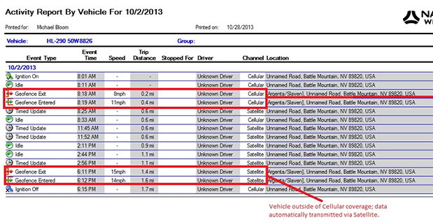
Navman Wireless USA today announced a new satellite communications option for its OnlineAVL2 fleet tracking platform, enabling continuous visibility of both heavy equipment and on-road vehicles even when assets are out of cellular coverage. Designed for construction, surface mining, mining and oil and gas exploration, and other environments with remote location work, the new solution includes the ability to minimize data charges by transmitting only the most critical event information via satellite.
Satellite connectivity is provided via a small modem that plugs into the serial port on Navman Wireless’ Qube on-highway or ruggedized Qtanium off-highway GPS tracking devices. The system automatically switches between cellular and satellite transmission with intelligent least-cost routing, using the global Iridium satellite network when fleet assets move out of cellular range. Benefits include:
Uninterrupted real-time fleet tracking without losing visibility of equipment location and other status information when assets are beyond the reach of cell towers.
Increased employee safety because equipment and vehicles are never out of sight of the fleet tracking system, even if they are working in cellular dead zones.
No missed engine alerts, potentially preventing costly machine repairs and downtime by ensuring that job supervisors are promptly informed when engine, coolant, transmission or air filter sensors connected to GPS tracking devices exceed pre-defined thresholds.
Cost-saving configurability, with the option to limit satellite transmissions to priority events (panic messages, rollover alerts, engine overheating, speed or geofence violations, etc.) and delay the transfer of low-priority event data until cellular coverage is restored.
“If a machine or vehicle in your fleet is operating outside of cell coverage and you have critical communications that need to take place for safety or operations reasons, it can be a problem to wait until the asset gets back into cell range,” said Davis Gammage, VP Product Management, Navman Wireless. “Temporarily switching to satellite communication solves the problem and ensures 100% visibility of your equipment as well as your field staff.”
The new satellite communications option marks the latest expansion of Navman Wireless’ fleet tracking portfolio for the construction, mining, and oil and gas industries. The company’s OnlineAVL2 fleet tracking platform provides location, operations and performance data for both on-highway vehicles and construction heavy equipment from a single interface. The back-end OnlineAVL2 application — delivered under the software-as-a-service model — includes industry-specific reporting such as jobsite utilization reports that break down equipment use by project, facilitate proper cost accounting, reduce writeoffs for unallocated asset hours, and aid in the development of future job bids for construction customers.
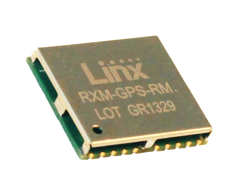
Linx Technologies announces its launch of the high-performance, low-cost RM GPS receiver modules. Using the built-in MediaTek MT3337 chipset, the RM module can simultaneously acquire on 66 channels and track on up to 22 channels, providing standard NMEA data messages through a UART interface. A simple serial command set can be used to configure optional features.
According to the company, the RM receiver module is a cost-effective GPS solution that offers no-frills, basic operation in a compact 15 x 13 millimeter package. The MediaTek MT3337-based RM Series is self-contained and only requires an antenna. It powers up and outputs position data without any software set-up or configuration, making the RM Series easy to integrate, the company said.
The receiver operates down to 3.0 volts and has a low tracking current of 12mA. The module has built-in receiver duty cycling that can be configured to periodically turn off the module for added power savings. This low-power consumption helps maximize runtimes in battery powered applications, such as consumer recreational positioning, marine, location and tracking, cargo tracking, and other asset monitoring systems.
In addition, the available GPS Master Development System connects a RM Series Evaluation Module to a prototyping board with a color display that shows coordinates, a speedometer and compass for mobile evaluation. A USB interface allows simple viewing of satellite data and Internet mapping, as well as custom software application development.
ABI Research forecasts that the global market for Driver Monitoring Systems (DMS) will reach 64.8 million units by the end of 2020 with the majority of shipments being accounted for in vehicles sold in the Asia-Pacific region. These findings are part of ABI Research’s Intelligent Transportation Systems Research Service and includes detailed installed base and forecasts of ADAS systems [advanced driver assistance systems] by regions.
Driver Monitoring Systems were first introduced as far back as 2006 when Toyota launched its innovative Driver Attention Monitor system. Toyota’s system functions by directly monitoring the driver’s face using a discrete in-dash camera and was initially offered as an option in the company’s luxury Lexus models. Other OEMs soon followed suit and announced their own DMS systems which were typically based on monitoring the vehicle rather than the driver’s face.
“DMS systems such as Mercedes-Benz’s ’Attention Assist’ and Volvo and Volkswagen’s ’Driver Alert’ systems were the first ADAS systems to be offered as standard equipment by OEMs, albeit only in a small selection of models,” comments Gareth Owen, principal analyst at ABI Research.
Today, an increasing number of ADAS systems are gradually becoming standard equipment in new cars, particularly in some European and Japanese brands such as Volvo, Mercedes-Benz, Nissan Infiniti, Lexus, and Mazda, and more are being offered as options. Although some of the big U.S. brands offer ADAS features in their European models, they typically do not offer the same features in their U.S. models, although this is beginning to change. Ford is a good example of this with its Ford Focus model.
“Another very observable trend in 2013 is that ADAS features are migrating from the luxury brands into B, C, and even A segment cars. Typically, the focus here is on offering ADAS systems, mostly as options, designed specifically for low-speed urban driving,” adds Owen.
Prices are decreasing, too. For example, the European Ford Focus offers an emergency braking system plus lane departure warning and lane-keep assist, driver alert, and blind spot monitoring as an optional package for £550 ($880) in the UK. Meanwhile, Volkswagen offers its City Emergency Braking System for £225-£405 ($360-$648), depending on model, on its budget A segment Up! car. This uses a laser sensor to detect the risk of an imminent collision and is active at speeds under 30 km/hr (18 mph).
By Miguel Torroja, Steve Malkos, and Christophe Verne
Users of smartphones, tablets, and other devices expect position with the highest level of accuracy, always available, with the least amount of power consumed. One recent improvement fulfilling this demand involves operating-system services for location on smartphones, and the evolution towards lower power solutions.
“Please connect to a charger — The battery is getting low: less than 15 percent remaining.”
Handsets are battery-supplied devices, and a user’s tolerance for features is driven by battery consumption. There are many examples of technologies where users do not run certain hardware or features because it will consume the battery and make the phone useless within a short period of time.
The application processor (AP) of a handset device is very powerful, and is the part that consumes most of the battery life. Today’s smartphone multicore application processor is faster than many desktop computers that are just a few years old. Whatever the application, when it uses the AP, it can draw up to hundreds of milliamperes (mAs).
For the last few years, the trend for GNSS has been host-based positioning. Host-based designs have less logic on the GNSS integrated circuit (IC) and employ the host AP for a portion of the positioning computation. This strategy has three advantages:
Shares memory and code resources with the application processor.
Reduces the cost of the dedicated GNSS hardware.
Sharing the processor makes sense since it is already running.
Traditionally, when the GNSS solution was running, a navigation application that utilized the AP was also running.
However, when we only want to compute GNSS positions in the background, and we do not need a third-party application running on the AP, a host-based IC architecture is not the optimal solution with regard to system power consumption. This article explains some of the technologies used to compute a GNSS position using an ultra-low power (ULP) hybrid solution that combines the classic host-based GNSS architecture with a host-offload architecture that minimizes the use of the AP.
We discuss here two applications that benefit from a host-offload architecture: geofencing and position batching.
We will review the requirements for a platform to support a new hybrid GNSS positioning solution. Different host-offload technologies for geofence, such as GNSS, Wi-Fi, and Cell-ID, will be compared. Broadcom’s ultralow-power host-offload GNSS solution supports any operating system. We focus here on Android’s operating system because it is the most open OS.
Always-on Applications
Geofencing is an application that sends reports or triggers alarms when a predefined area is crossed. For example, users can be alerted to discounts with e-coupons when walking through a mall, or to “don’t forget the milk” — users can set their own reminder notifications based off of location; also, social networking. One example of location-based reminders is through Google Keep, which uses Android’s Geofence APIs on platforms that support hardware geofencing; this application will automatically take advantage of the hardware geofence solution.
Geofencing applications run in the background for long periods of time, and their main task is to compute positions (fixes) without the need of assistance from other applications. An ultra-low-power GNSS position solution, or always-on positioning solution, is desirable for these scenarios. Typical applications require notifications when entering or exiting a geofence area, or require periodic reporting of user positions relative to the fence.
Geofencing is not something new. API support has been provided in mobile OS for many years, but only now can it be used without draining the battery, thanks to this new host-offload architecture.
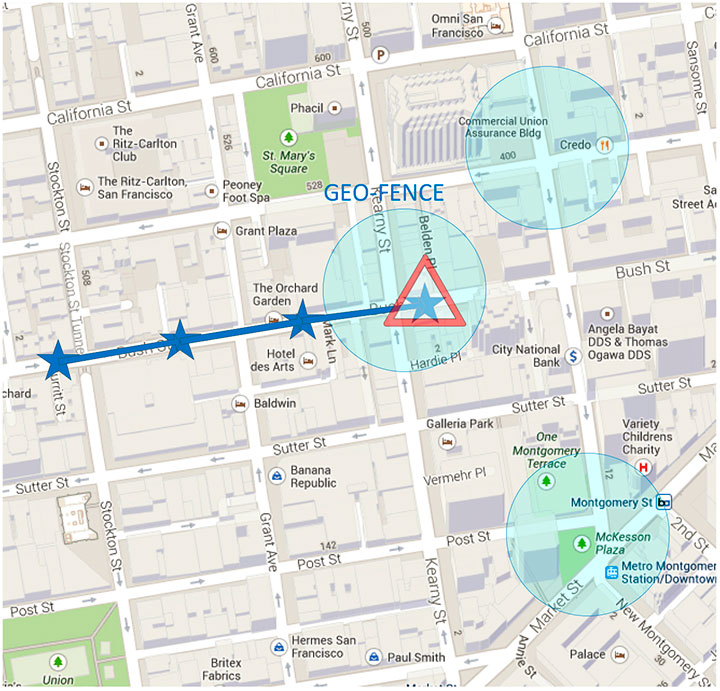
Figure 1 shows a circular geofence boundary and an alarm. In that example, the alarm was triggered when entering the fence.
Figure 1. Alarm when the vehicle enters a geofence area.
Breadcrumbing or position batching pertains to storing of positions, referred to as crumbs, which are accumulated for a certain amount of time and then pushed all at once to the application. Examples would be fleet or asset tracking applications, or people that wants to track their position while they are running.
Currently, Android does not support breadcrumbing as a native feature. There is some ongoing work, and APIs are being defined.
GNSS Positioning Models
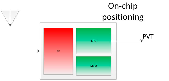
Before smartphones, the dominant GNSS hardware architecture employed a system-on-chip solution. The position/velocity/time (PVT) comes directly from the hardware, and all the computations are done in the GNSS IC.
On-Chip Positioning requires two things: a powerful-enough central processing unit (CPU) and lots of memory. The increase in CPU and memory performance are not free; they translate directly into more power and higher manufacturing costs.
The RF block in Figure 2 is intentionally drawn with a similar size to the CPU and memory, to emphasize the need for higher resources for a complete on-chip solution.
Figure 2. On-chip solution.
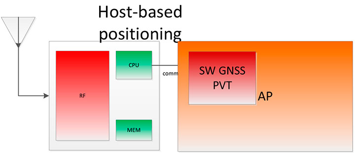
Host-Based Solution. GNSS positioning requires dedicated hardware, complex software, and protocols. This complexity led GNSS providers to move parts of the software out of the IC to the AP.
Using a mobile phone’s AP for position computation is one method of reducing the CPU and memory power footprint from the GNSS IC. At the same time, it also increases the power consumed by the platform needed to compute GNSS position, since part of the computation is not performed on the host-based IC. APs may consume approximately 100 mA just to be operational.
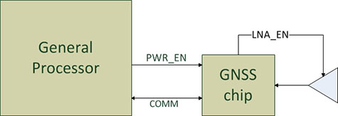
Figure 3 shows a typical configuration with dedicated GNSS hardware and a generic AP. In host-based mode, both the AP and the GNSS IC run in parallel when computing positions. The AP controls the GNSS hardware.
Figure 3. I/O connections in on-host positioning.
With this type of shared architecture, shown in Figure 4, the CPU and the memory on the GNSS IC are reduced, shrinking the size of the chip and reducing power consumed by the chip. In Figure 4 we see that the AP is communicating with the dedicated hardware, and the final PVT is computed by the AP. This solution fits well in many applications, such as navigation, where the AP has to run a mapping application at the same time.
Figure 4. Host-based solution.
Hybrid Positioning. For geofencing, we need a hybrid model, one which keeps GNSS IC complexity similar to the host-based architecture, but also offloads some of the host-based positioning so that the host can go to sleep.
In Broadcom’s hybrid mode, the AP does not need to run when GNSS positions are computed. Broadcom’s hybrid IC does not invoke the host AP often, and thus achieves an even lower power footprint. The CPU on the GNSS IC used for computing position is a dedicated one. It needs to be carefully chosen because it has to be powerful enough to compute positions and be as power efficient as possible. All this is done while keeping the GNSS IC area size in mind, to control cost.
Detailed analysis and steps were considered to ascertain the minimum requirements for the CPU and other resources to best accomplish the on-chip positioning task.
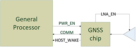
Other considerations: the GNSS IC must be powered even when the AP is suspended, and the GNSS IC must be capable of waking up the AP. Figure 5 shows a possible implementation using a dedicated I/O signal controlled by the IC to wake up the host AP.
Figure 5. I/O connections in hybrid positioning.
With this architecture, the host AP will still be needed to provide some assistance data to the GNSS IC. The assistance provided allows the GNSS IC to not invoke the host AP often and thus achieve an even lower power footprint.
Geofencing Methods
Certain OS application APIs have been supporting geofencing for many years. Currently, we can find geofencing APIs in most of the mobile OSs in the market.
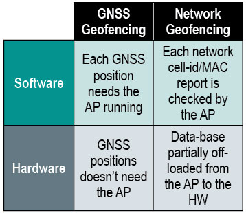
There are four main types of geofencing: GNSS software geofencing, GNSS hardware geofencing, network software geofencing, and network hardware geofencing (Table 1).
Table 1. Geofencing methods.
GNSS Hardware Geofencing. In this method, the one described in detail in this article, the OS initiates a request and offloads the areas of interest to the hardware. After that, the AP can go to sleep and the hardware is responsible for computing positions and checking the areas of interest. This method basically relies on GNSS hardware to compute positions and check the programmed fences.
GNSS Software Geofencing. Here, the OS initiates regular fixes to a host-based GNSS IC design. Then it invokes both the AP and the GNSS IC at the same time to check against the defined fence areas.
Network Geofencing. In this method, the OS requests network IDs from the hardware (that is, baseband modem Cell-ID and Wi-Fi access points). The OS uses different positioning technologies to compute position. This usually requires a connection to a server to retrieve location information about the different IDs. The position is used to check the geofences.
In network hardware geofencing, a set of network IDs is offloaded from the OS to the network hardware ICs. The hardware can poll for these IDs, and wake up the host when found.
Network versus GNSS Geofencing
A good geofencing solution combines both network and GNSS methods because each solution benefits from each other.
GNSS positioning solutions compute positions in open-sky environments with accuracy to a few meters and have worldwide coverage. However, they cannot work in deep indoor spaces.
Network geofencing using cell IDs is quite inaccurate, but works very well indoors. Network geofencing using a Wi-Fi access point provides reasonable accuracy, but location of the access points is not always known and it does not have full coverage.
Geofencing in Android 4.3. The API for applications supports geofencing. Starting from the first version of Android, the application just initiates a proximity alarm and will get an event when its boundaries are crossed. The OS is responsible for notifying the application when such an event occurs, and can use any technologies it sees fit.
The API that applications use is very simple. The monitoring is handled by the OS and is hidden to the application (for example, technologies, periodicity of checks, and accuracies).
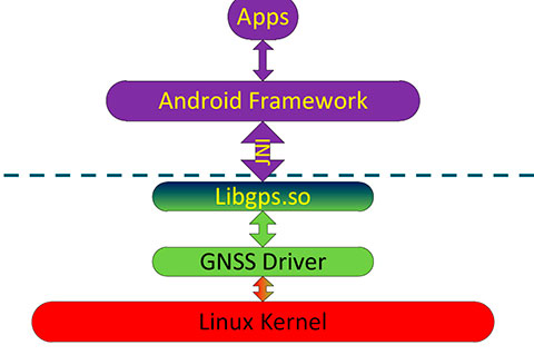
Software Geofence in Android. Software geofencing has been the default method until recently, as there was no native hardware support. In this mode, the host-based GNSS positioning engine is started like any other position request. The Android framework is the one dealing with the monitoring of the geofences, and therefore, the AP must run continuously to handle periodic position checks. That means the software-geofencing logic is mainly in the framework layer of Android (see basic layers diagram shown in Figure 6).
Figure 6. Android framework.
More recent versions of Android dropped the support for software-based geofencing in favor of a host-based GNSS system, likely because of the big impact on the battery. Broadcom developed a low-power GNSS hardware solution for geofencing.
Hardware Geofence in Android. Starting from Android 4.3, a new interface is available to use hardware geofencing. This interface is not visible to the application, and it is only used as a low-level interface. To support the new hardware-geofence interface, the native driver only has to register to a new GNSS interface defined in the native hardware abstraction layer (HAL) of Android.
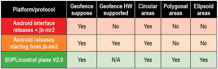
There are other protocols known to support geofencing. Table 2 provides a short list.
Table 2. Geofencing support on different platforms.
Broadcom Hybrid Positioning
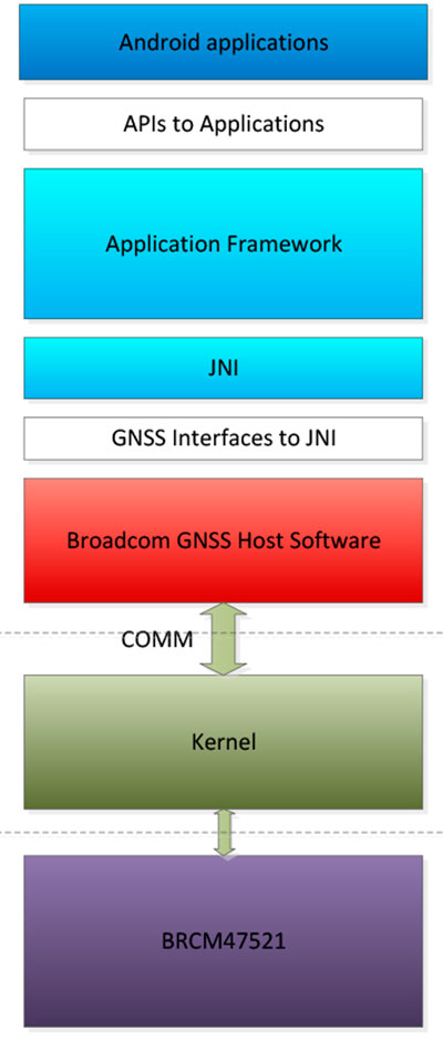
Android defines interfaces to the hardware, referred to as the HAL.
GNSS Host Software. GNSS providers need to comply to the HAL interface, which is at the Java native interface (JNI) level. Below the JNI lies the GNSS host software (Figure 7).
For the host-based solution, the GNSS host software handles most of the heavy computing.
For the hybrid solution, the GNSS host software does some of the heavy computing, but positions are computed inside the GNSS IC.
To support this new hybrid solution, two main changes are required compared to the usual host-based solution, as described below.
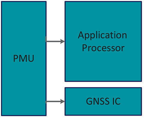
First, the hybrid GNSS IC must be autonomous while the host AP is sleeping. This implies that some power domains are maintained when the GNSS is in use. This typically means at least one of the outputs of the power management unit (PMU) should be dedicated to the GNSS only (Figure 8).
Figure 8. Power domains.
Second, the GNSS IC must be able to wake up the host AP so as to send geofence notifications, or to request assistance data. This is usually done through a dedicated pin.
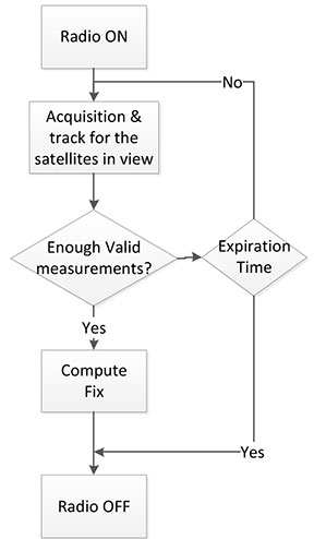
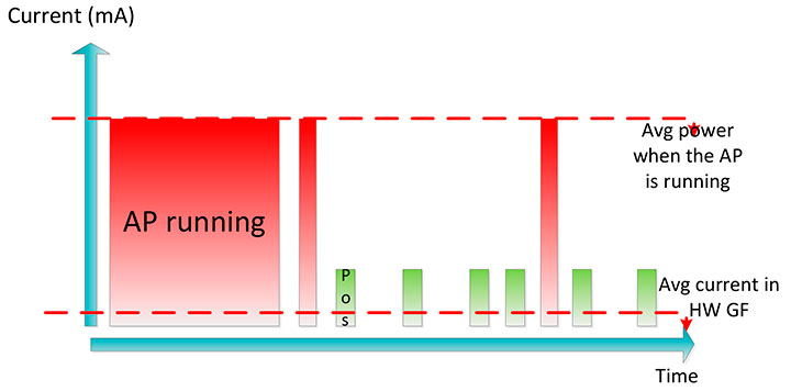
Acquisition and Sleep Period. Most of the power in the GNSS IC is used by the radio and analog part. To reduce power, this part is switched on only during acquisition. As soon as enough measurements are observed, the radio part is switched off while the digital part computes a fix.
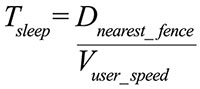
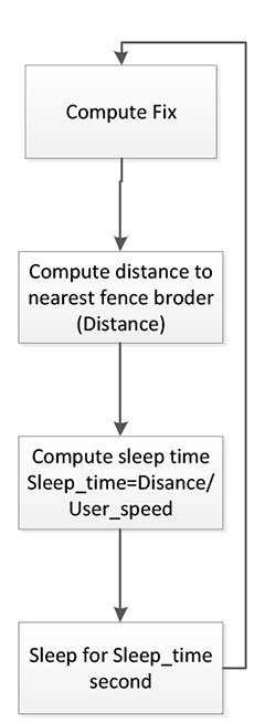
After each computed position, the GNSS IC can go into a deep power-saving mode until the next acquisition. The distance to the closest fence in conjunction with the user speed is used to determine when to compute the next position (Figure 9):
Figure 9. Start fix decision logic.
Once the GNSS IC starts computing positions, the AP can go into sleep mode (Figure 10). Total power per position computed is reduced, and the time between fixes is no longer constant, as shown in Figure 11.
Figure 10. Sleep time between fixes.Figure 11. Duty cycling.
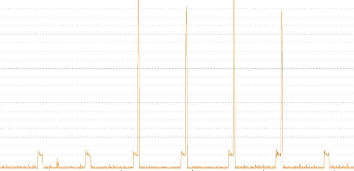
In Figure 12, the lower square-shaped pattern corresponds to a position computation from the hardware GNSS IC. Once we have an alarm, the host has to be woken up and we can see the impact in power in the big peaks after a position is computed.
Figure 12. Power graph.
Alarm Triggering
When a geofence area is crossed, the GNSS IC needs to wake up the AP. This is achieved using a dedicated interrupt pin. After asserting it, an alarm and geofence status is sent to the AP.
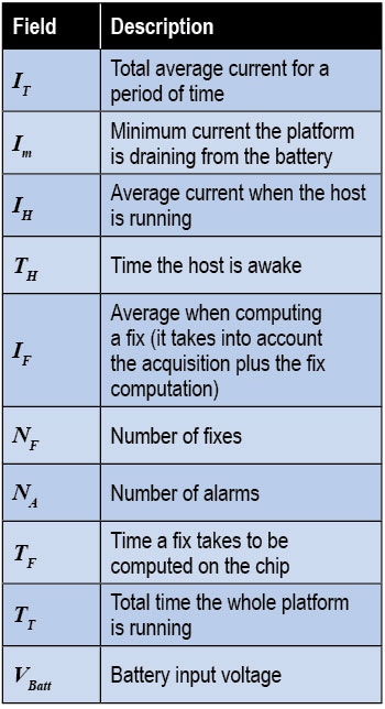
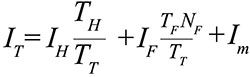
Power Consumption. We calculate the total average current by splitting it into three components, as shown in the following formula:
Some of these parameters are set by the host: for example, how often the fix should be computed. The extra current drained by the GNSS IC is the one defined by
∆I is the change in current drain when computing positions.
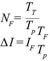
We can also express this formula based on the average number of position attempts:
where Tp is the average time between fixes (the time the GNSS IC stays in sleep).
Table 3 illustrates some theoretical ∆I current savings with respect to Tp.
Conclusion
As APs become faster and faster, their power consumption goes up. A novel hybrid GNSS receiver has been presented, which offloads some of the host-based processing into the GNSS hardware, offering ultra-low system power consumption versus the traditional methods. The new hybrid positioning solution is a good approach for always-on applications that need to have location information always available, without requiring the host to be running, as is the case with geofencing and breadcrumbing.
References
We would like to thank Jason Goldberg, Frank van Diggelen, and Manuel del Castillo, all of Broadcom, who reviewed this article and spent many hours with us discussing the topics point by point.
Miguel Torroja is a principal software developer at Broadcom. He has an M.Sc. in electrical engineering from Ramon Llull University, Barcelona. Since 2011, he has been working on the design and development of algorithms for optimizing power consumption in GNSS host-offload solutions.
Steve Malkos is a senior program manager at Broadcom. He has a B.S. in computer science from Purdue University. He has been active in the development of A-GNSS technologies such as hybrid location services, long-term predicted orbits (LTO), Broadcom’s worldwide reference network (WWRN), and secure user-plane location (SUPL). He has five patents issued and 16 pending.
Christophe Verne is a manager of software engineering at Broadcom. He has an M.S. in electrical engineering from Ecole Centrale, Paris. He has been involved in the development of GNSS and A-GNSS technologies at EADS, Sagem, Global Locate, and Broadcom, where he has been working on low-power host-offload positioning.
ORBCOMM Inc., and Savi Technology have announced a strategic relationship to provide advanced location-based monitoring solutions to government and commercial markets.
ORBCOMM is a global provider of machine-to-machine (M2M) solutions, and Savi Technology is a provider of sensor-based analytics and radio-frequency identification (RFID) solutions.
ORBCOMM and Savi have submitted a proposal in response to the U.S. Army RFID IV project, which will provide both ISO18000-7 RFID tags and a suite of satellite solutions for military logistics support. ORBCOMM’s GlobalTrak division has been a leading player in providing military Enhanced-In-Transit-Visibility (EITV) solutions to the government market since 2008, and Savi has been a market leader in military RFID solutions, enabling it to offer vast market experience with the right blend of technology platforms for this proposal.
“The combination of ORBCOMM’s satellite expertise and broad network service portfolio with Savi’s state-of-the-art RFID technology offers a full spectrum of innovative monitoring solutions to our collective market base with focus on our government and international customers,” said Marc Eisenberg, Chief Executive Officer of ORBCOMM. “Although RFID and satellite tracking have traditionally been divergent technologies, the synergy of these solutions within a common operating environment creates a seamless transition from infrastructure to wireless-based location services for tracking and monitoring high-value assets.”
“By bringing two market leaders with highly complementary technologies together, we have created a best-of-breed solution for our customers in both government and commercial markets,” said Bill Clark, chief executive officer of Savi Technology. “This relationship will support Savi’s operational analytics capabilities by providing additional ways to collect critical data and deliver timely and reliable operational intelligence to our customers. We look forward to partnering with ORBCOMM on RFID IV and other global opportunities in the near future.”
Ford is studying communications between space robots and Earth to enhance future applications of the connected-car communications protocol. The research furthers the company’s commitment to the development of connected vehicle communications to help reduce traffic congestion and aid in the advancement of emergency vehicle communication methods, Ford said.
Ford has launched a three-year research partnership with the telematics department of St. Petersburg Polytechnic University in Russia in its association with that country’s space industry. The goal is to analyze space-based robotic communications systems for vehicle mesh networks to aid in mobility solutions.
The development of connected vehicle communications has the potential to reduce traffic accidents and ease congestion by enabling vehicles to communicate with each other, and to communicate with buildings, traffic lights, the cloud and other systems to deliver a message or detect and respond to imminent collision warnings.
All major international car-makers are installing telematics units, sending a signal that wireless information and connectivity is here to stay in the vehicle, and location will be a big part of the growth. To learn more about the rapid changes in the connected vehicle field, tune in to our September 19 webinar, hosted by Wireless LBS editor Janice Partyka. Registration is free.
“Ford has been committed to the research and development of connected vehicle communications for more than a decade,” said Paul Mascarenas, chief technical officer and vice president, Ford research and innovation. “Our participation in this research can aid in the development of next-generation Ford driver-assist technologies. These technologies will globally benefit Ford customers, other road users and the environment.”
Emergency Situations. One promising development from Ford’s research project with St. Petersburg Polytechnic University is the advancement in emergency vehicle communication methods. Ford is analyzing how emergency messages should be sent to ensure delivery if network failures were to occur, identifying the systems and methods that provide redundancy in case of primary delivery failure.
For example, if an accident were to cause vehicle-to-cloud communications (V2C) to be broken, a vehicle may still have access to a vehicle-to-vehicle (V2V) communications network. An emergency signal message could potentially be sent through V2V to a vehicle nearby, and then between vehicles and infrastructures until it reached EMS.
“The research of fallback options and robust message networks is important,” said Oleg Gusikhin, technical leader in systems analytics for Ford. “If one network is down, alternatives need to be identified and strengthened to reliably propagate messages between networks.”
Space Telematics. Telematics — the long-distance transmission of digital information — developed for use on space stations provide excellent potential for improving the reliability of future vehicle-to-cloud, vehicle-to-infrastructure, vehicle-to-vehicle and other forms of communication (V2X). The communications blend multiple networking technologies including dedicated short-range communication (DSRC), cellular LTE wireless broadband and mesh networking to ensure robust and reliable connectivity for optimum signal strength for critical messages.
Using the knowledge accrued from analyzing the space robots, Ford engineers could then develop an algorithm that is integrated into the V2X system resulting in a message that would route through the appropriate network depending on the level of its importance. An emergency message, for example, may be communicated through the faster mesh network, whereas an entertainment-related message would route through a vehicle-to-infrastructure application, an embedded device or a brought-in device network.
“We are analyzing the data to research which networks are the most robust and reliable for certain types of messages, as well as fallback options if networks were to fail in a particular scenario,” said Oleg Gusikhin, technical leader in systems analytics for Ford. “In a crash, for example, a vehicle could have the option to communicate an emergency though a DSRC, LTE or a mesh network based on the type of signal, speed and robustness required to reach emergency responders as quickly as possible.”
Here is a video showing how Ford is studying space robot communications.
Findings from this work could potentially enhance Ford’s wireless communication technologies and Blueprint for Mobility. Ford’s Blueprint for Mobility details the company’s vision on how to tackle the issues of mobility in an increasingly crowded and urbanized planet between now and 2025.
HERE, a Nokia business, has announced a complete Connected Driving offer, which will help car makers and in-vehicle technology suppliers connect the car and the driver to the cloud. The offering includes HERE Auto, HERE Auto Cloud, and HERE Auto Companion. In addition, HERE has radically improved its Traffic product, HERE Traffic, by building a new system to process data even faster and more accurately than before, Nokia said. The HERE Connected Driving offering will be demonstrated at the International Motor Show in Frankfurt, Germany, starting on September 10.
All major international car-makers are installing telematics units, sending a signal that wireless information and connectivity is here to stay in the vehicle, and location will be a big part of the growth. To learn more about the rapid changes in the connected vehicle field, tune in to our September 19 webinar, hosted by Wireless LBS editor Janice Partyka. Registration is free.
Technology is rapidly transforming driving, with connectivity bringing the outside world to the car and the sensor revolution creating new possibilities for the automobile industry, Nokia sai,d. People today demand that cars become integrated into their ecosystem of connected devices with the same level of innovation they see in their personal devices.
HERE Connected Driving offers a full range of automotive products and services that builds on our high-quality and fresh map to go beyond navigation. The customizable offering is a fully flexible framework that allows automakers to differentiate the driving experience. It will help them solve the problems that drivers face every day such as synching routes and other personal information across their car and devices and finding the right parking spot or closest gas station.
HERE Auto is the first embedded in-car navigation experience that delivers the right map at the right moment with and without a data connection. Drivers can get turn by turn voice guided navigation in 95 countries and 2D, 3D and satellite map views including street level imagery. In the future, car makers will be able to easily extend the HERE Auto experience using a software development kit (SDK) to create entertainment and other applications, such as in the areas of music and social networking. HERE Auto is already integrated in Continental’s next-generation Open Infotainment Platform. HERE is also working with partners such as Magneti Marelli and others to bring HERE Auto to the market in the coming months.
HERE Auto Cloud provides drivers with always-on access to several dynamic services such as real-time traffic updates, helping drivers avoid congested areas, road closures or blockages that occur en route. Drivers can also get recommendations on places to eat, parking spots, information on where to charge an electric vehicle or where to find the most inexpensive fuel.
HERE Auto Companion, a customizable mobile and web application, keeps drivers connected outside of the car allowing them to synchronize their favorite places and routes across their devices so that they won’t need to re-enter their route when they get in the driver’s seat. Car makers can tap assets from the existing HERE suite such as walking navigation, public transit routes and even indoor venue maps to build custom mobile applications. Drivers could use the app to remotely find their car with their device using LiveSight augmented reality technology and check the car’s vital stats such as fuel levels and tire pressure.
HERE Traffic has been radically improved by “Halo,” our new engine that processes data quickly and accurately. Every month we’re collecting ever greater numbers of high-quality data, such as probe points and sensor information to deliver real-time information such as weather, traffic congestion, road construction and other factors that affect a drive. With our new Traffic product drivers get improved travel time estimates, so they can better plan their routes and quickly re-route on the go.
“By 2016, the majority of consumers in mature markets will consider in-vehicle web-based data access a key criterion in their automotive purchase,” said Thilo Koslowski, VP of Automotive at Gartner. “Successful connected vehicle solutions will add value to the connected driver’s digital lifestyle and enable integrated cross-device experiences relevant for people everyday.”
GPSTrackit’s Fleet Manager Software now features an Analytics Dashboard that enables fleet managers to monitor and review fleet performance by reviewing historical data in a series of charts and graphs. Fleet Manager is a robust application providing fleet owners and managers with a comprehensive suite of integrated tools, GPSTrackIt said. The system delivers real-time GPS vehicle tracking, vehicle maintenance scheduling, and a wide range of alerts. The Analytics Dashboard brings to the system a new array of powerful and flexible capabilities.
“It puts the information fleet managers and owners need at their fingertips,” said Eddie Bermudez, GPSTrackIt’s product manager. “We already provide all the historical data via the reports system. This new feature brings that data to life with dynamic graphics.”
The dashboard displays up to six charts, which can be configured as bar charts or pie charts. Each chart can focus on particular issues important to fleet owners, managers and dispatchers: Idle Time, Drive Time, Stop Time, Speeding and Mileage.
“The charts can be configured to show data for all units or a single group,” explained Bermudez. “Or a chart can compare groups by displaying their data side-by-side using different colors.”
In addition, three composite charts are available; Engine Time, which monitors idle time and driving time; Driving Overview, which monitors idle time and driving time and stop time; Idle Stop, which monitors idle time and stop time. The time metric determines which historical data is used. Options available are week, month, quarter, and year.
“Charts can be rearranged on the dashboard by dragging and dropping,” added Bermudez. “And there are several additional options that can be configured. Chart labels of up to 25 characters can be added. The start of day can be set to any of the 24 hours. For bar charts, the average value can be shown superimposed on the graph.”
Bermudez continues, “The Analytics Dashboard can also display the highest or lowest values for a given graph. This can be configured to show values from one to 20. Selecting Highest and a numerical value of five on an Idle Time chart, for example, displays the five vehicles with the highest values for idle time.”
“This is important for fleet managers to know because of added fuel consumption, as well as vehicle wear,” according to Bermudez. ”Selecting Lowest and a numerical value of ten on a Speeding chart shows the ten vehicles with the lowest incidence of speeding.”
Qualcomm Incorporated has signed a definitive agreement to sell its fleet management and tracking business Omnitracs to Vista Equity Partners for $800 million in cash.
The acquisition will include all of Omnitracs operations in the U.S., Canada and Latin America, including Sylectus and FleetRisk Advisors, which were acquired by Omnitracs in 2011. The transaction is expected to be completed during the first quarter of Qualcomm’s fiscal 2014.
Omintracs, formerly known as Qualcomm Enterprise Services, provides integrated fleet management applications, services and platforms to transportation and logistics companies. The company provides solutions for safety and compliance, driver retention, GPS fleet tracking, and fleet maintenance software.
“In the late 1980s, Qualcomm pioneered the use of commercial vehicle telematics with the introduction of the first mobile information system for transportation and logistics,” said Qualcomm executive vice president Derek Aberle. “As one of Qualcomm’s earliest businesses, Omintracs has maintained a leadership position within the industry for 25 years. Today, the opportunity for fleet management and telematics is evolving rapidly, and we believe Omnitracs is well positioned to continue its leadership position as a stand-alone entity.”
“We are long-term investors in enterprise software, data and technology-enabled businesses that are committed to being leaders in their fields,” said Robert Smith, chief executive officer and founder of Vista Equity Partners. “We are impressed with the compelling value proposition Omnitracs’ products and services offer their customers. We look forward to working with them and helping them to reach their full potential.”
The closing of the transaction is conditioned upon, among other things, clearance under the Hart-Scott-Rodino Antitrust Improvements Act of 1976 and other customary closing conditions.
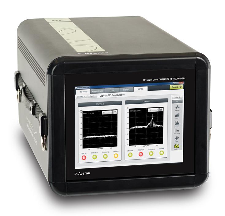
Averna’s Record & Playback platform. Photo: Averna
Averna, a developer of test solutions and services for communications and electronics device makers, announced today that Clarion has selected Averna’s Record & Playback solution to validate upcoming in-vehicle entertainment systems and certify that the devices perform well in real-world conditions. Clarion is a global manufacturer and seller of car navigation systems and in-vehicle equipment with a focus on car audio systems.
The R&D Division, Experiment and Evaluation Team at Clarion will use Averna’s R&P platform to record radio signals such as AM, FM, HD Radio, and DAB from key locations around the world and replay them in the Tokyo-based lab where the design team is located.
The R&P platform selected by Clarion features:
RP-5100, a compact 2-channel RF recorder designed to record live RF signals in the field
URT-5000, a software-defined RF Player and Signal Generator
RF Studio, high-performance RF record-and-playback software for RF product designers and researchers to facilitate recording, analysis and storage of RF signals
DriveView plug-in for synchronized recording/viewing of video, audio, and GPS positioning data
The Averna RP-5100 RF Recorder is specifically designed to capture real-world RF signals, with impairments, for navigation as well as broadcast radio and video receiver validation, testing and support. The system has two 20-MHz wide channels that can be tuned on any frequencies from 250 kHz to 2.65 GHz. To address the challenges of validating the RF response with the physical environment, Averna has developed DriveView, a plug-in for the proprietary RF Studio software, offering visual verification by video-recording drive tests.
“Clarion needed a platform to record live RF environments and reproduce them in a repeatable manner in their lab. Our R&P solution allows them to go through all the different use cases without having to go back in the field at each testing phase,” said Etienne Frenette, VP of Sales, Asia for Averna. “As receivers become more complex, it is imperative that real-world signals and conditions be recreated for thorough validation and testing in order to help enhance the user experience.”
“We recognize and appreciate Averna’s unique expertise and advanced solutions in device performance testing,” commented the R&D Division, Experiment and Evaluation Team at Clarion. “Clarion is dedicated to delivering better products reaching the market faster and Averna is helping us achieve this goal.”
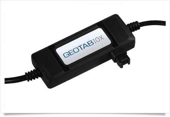
Geotab has launched a telematics Near Field Communications (NFC) Driver ID solution using an Input-Output-Expander (IOX) that allows for simultaneous connections and communications to occur with multiple devices, such as Garmin, Iridium, and HOS.
As an addition to its comprehensive fleet management platform, the technology will now help managers keep better track of each driver’s productivity and on-road safety — no matter which vehicle they are in, Geotab said.
With one touch of the NFC fob, vehicle operators can quickly, easily, and securely transfer their driver identification information to the cloud. Since Geotab’s GO6 device allows for multiple plug-and-play connections, the NFC Driver ID solution can be setup in minutes, the company said. Associating drivers with the vehicles they are in also allows for the software to generate driver-based score reports.
“The newly launched NFC Driver ID is a telematics industry game-changer that provides a reliable and accurate solution for businesses which pool their vehicles,” said Colin Sutherland, Geotab VP.
“NFC is seeing rapid application expansion across smartphones, tablets, and laptops. We fully expect to leverage this technology for future applications,” added Neil Cawse, Geotab CEO.
Although Geotab is launching a new Driver ID solution based on NFC, Geotab’s web-based software, MyGeotab, has been reporting both driver and vehicle summary value reports for over 10 years. The NFC Driver ID solution is now available for purchase through Geotab’s extensive Authorized Reseller network.