Extensis and LizardTech are uniting as one global company to help organizations increase their return on investment and the value of their digital assets, fonts and large imagery.
In 2017, Extensis and LizardTech collaborated on the development of new portfolio asset geo-referencing capabilities for applications in the geospatial, infrastructure, architecture/engineering/construction and building information modeling segments.
With Extensis’ market leadership in digital asset and font management combined with LizardTech’s expertise in image management and image compression technology, the united company is situated to provide a suite of solutions and support for digital asset challenges.
“Organizations today are investing in imagery of all kinds, including photography, aerial, and spatial, to name a few,” said Osamu Ikeda, CEO of Extensis. “Fully leveraging these digital files means having an easy and efficient way to organize, store, access and distribute them.”
Ikeda continued, “Uniting Extensis and LizardTech strengthens our ability to support our customers’ success and give them effective and time-tested solutions for maximizing the value of digital assets of all kinds.”
The combined company will operate under the Extensis brand, headquartered in Portland, Oregon, with an office presence in Seattle.
Starting now, LizardTech products (GeoExpress, Express Server, GeoViewer) will become part of the Extensis suite of solutions, which spans digital asset management, font asset management, brand asset management, image management and image compression.
The Connected Citizens Program, a two-way sharing of publicly available traffic and road condition information, offers governments a stream of data, constantly updated in real-time, whenever they need it. This enables personnel to make data-driven infrastructure decisions and improves the efficiency of incident response.
Waze, a free crowdsourced traffic and navigation app, is now fully supported by ArcGIS Online, where its live feed of mapped traffic alerts and other information, such as accidents, congestion and street damage, can be used in applications in minutes.
“Municipalities can now leverage near up-to-the-minute reports without having to write code or purchase additional software,” said Andrew Stauffer, manager of civic technology at Esri. “Mapped Waze data is available immediately in all ArcGIS apps, where traffic engineers and even city planners can use it to maintain and build safer, more efficient transportation systems.”
Municipal personnel like traffic engineers can start using this data to analyze where the biggest problems exist on the roads so they can create targeted solutions. For instance, by seeing exactly where the most crashes are occurring, engineers can know where they need to place more officers, replace street signs, or adjust the timing of traffic lights.
“The Waze Connected Citizens Program is all about removing any barriers to innovation,” said Adam Fried, Waze Global Partnerships manager. “We want to help our partners leverage existing infrastructure and be able to make better data-driven decisions. Now, with just a couple of clicks, a city can easily access and analyze Waze data within Esri ArcGIS and use those insights to improve roadway management and build safer roads for its citizens.”
Much of the information government organizations rely on to make decisions is becoming obsolete as communities are starting to use technology like sensors and drones to monitor the quality of roads, bridges, and utilities. The Waze Connected Citizens Program gives municipalities the power to harness crowdsourced driver data to not only improve safety and congestion but also make better-informed decisions by giving planners an edge to start building infrastructure that meets the demands of a twenty-first-century city.
Governments can sign up for the free Waze Connected Citizens Program and start working with the alert data in ArcGIS to create operational dashboards that departments can use right away.
Bentley Systems, a global provider of comprehensive software solutions for advancing infrastructure, has acquired Plaxis, provider of geotechnical software, based in Delft, Netherlands.
Bentley has also agreed to acquire soil engineering software provider SoilVision, based in Saskatchewan, Canada.
The acquisitions, with Bentley’s market-leading borehole reporting and data management software gINT, serve to make Bentley a complete digital source for geotechnical professionals.
With the acquisitions, building information modeling (BIM) advancements can be extended to the essential subsurface engineering of every infrastructure project.
Projects necessarily begin with geotechnical surveys and sampling, captured with gINT for versatile documentation and reporting.
Next, professionals perform engineering related to soil properties, soil behavior, and groundwater flow using SoilVision’s SVOFFICE applications, supplemented by Plaxis’ offerings.
Then, soil-structure interaction is analyzed through Plaxis’ design, simulation, and engineering software (for example, PLAXIS 2D, PLAXIS 3D).
The new opportunity, by way of digital workflows enabled through Bentley’s comprehensive modeling environment, is for geotechnical applications to be integrated with Bentley’s structural applications (such as STAAD, RAM and SACS) for unprecedented geo-structural engineering performance.
As changes may occur in owner requirements, structural strategies or site conditions (continuously surveyed through UAVs and Bentley’s ContextCapture for reality modeling), geotechnical analysis could be continuously applied for improved outcomes, as managed through ProjectWise collaboration services.
For today’s infrastructure demands, geotechnical considerations are coming to the fore.
Urbanization, for instance, drives growth both vertically and underground, with emphasis on the capacity of foundations and tunnels. And new infrastructure projects of every type depend upon constructed dams, embankments, dikes, levees and reservoirs to improve their resilience.
Moreover, new asset types such as offshore wind turbine structures require new geotechnical analysis capabilities, in this case to be accomplished with Plaxis’ forthcoming MoDeTo software.
Because infrastructure assets are crucially linked to subsurface environs, they are vulnerable to geo-environmental risks including seismic activity, subsidence and weather impacts. Leveraging new digital workflows which incorporate real-time monitoring and analytics during infrastructure operations, geotechnical professionals can play the increasingly valuable role they deserve in achieving geo-environmental resilience.
“My colleagues and I welcome our new teams from Plaxis and SoilVision, which have in common a zeal for applying science for better engineering practice,” said Greg Bentley, Bentley Systems CEO. “Dr. Ronald Brinkgreve from Plaxis and Dr. Murray Fredlund, founder of SoilVision, exemplify this. I believe that every geotechnical engineer has benefitted from Plaxis’ continuous advancement, in scope and quality, of tools for their discipline to add value. With a professional and dedicated management team led by Jan-Willem Koutstaal, Plaxis has become one of the most successful software businesses I have ever seen.”
Bentley added, “While most infrastructure engineering disciplines converged around intuitive 3D models, geotechnical applications seem to have followed a less graphically intensive development path, and so have remained isolated from cross-discipline workflows. This ‘disconnected’ mindset prevailed even while Plaxis, SoilVision, and gINT mainstreamed 3D innovations. Our BIM platform’s comprehensive modeling environment will finally embrace the geotechnical profession in digital workflows for every infrastructure project and asset.”
Tony O’Brien, global practice leader for geotechnics for Mott MacDonald, said, “PLAXIS is one of our core analysis tools being used across our global geotechnics practice. When used by experienced specialists, PLAXIS can analyze many of our most complex ground-structure interaction problems. In Bentley’s hands, we have high expectations that we can accomplish more through digital workflows made possible through integration of PLAXIS technology with Bentley’s comprehensive modeling environment—workflows that are compatible with Mott MacDonald’s commitment to connected thinking and solving complex infrastructure challenges.”
While not as glamorous as mild-mannered Clark Kent holding down a day job while Superman comes to the rescue in time of crisis, there are professional surveyors who work day jobs to perform our duties as practitioners to make a living and participate in association activities in their off-hours to help promote and protect their profession as well as the public they serve.
Many of the hours spent to protect the profession are in the political arena, where the battle for budget dollars and service rights are fought on nearly a daily basis. Because of the reliance of the surveyor on technological advances, the profession has been thrust into the political arena at all legislative levels. The surveyor has been tasked with leading the discussion and help the public understand why significant dollars are needed for funding many different programs to continue with our high-tech trends and lifestyles.
Three of the four presidents on Mount Rushmore started as surveyors — George Washington, Thomas Jefferson and Abraham Lincoln. (Photo: National Park Service)
The role of the surveyor has not been considered political even though several significant U.S. presidents were surveyors in their early careers. Surveyors aren’t particularly known for their public personas, much less their political prowess. Other than states that still have county surveyors, rarely do practitioners stray beyond local municipal government. One is more likely to see a professional engineer or architect as an elected official than a surveyor, but that doesn’t mean the issues we face are any less important.
My current position is a professional land surveyor with a full-time job overseeing a department in a multi-discipline office in a major metropolitan area. Besides being a contributing editor to GPS World through these articles, I also voluntarily wear many hats within our state association and the national surveying society. Several of these hats are government affairs positions at both state and federal levels, as it has become a full-time operation to keep a watchful eye at all governmental levels. From changes in regulations, budgetary revisions and threats to our professionl by outside entities, government affairs take a small army of people to keep abreast of all situations.
This month’s submission is just a snapshot of the current National Society of Professional Surveyors (NSPS) Joint Government Affairs Committee action item list being addressed and monitored through its committee members and a governmental lobbyist. The importance of this list is to give the reader a sampling of the seemingly endless battles being waged on Capitol Hill by NSPS and its members nationwide.
All these issues have GNSS at their heart and will have dire consequences if any of these subjects fall short of their intended marks.
This is not just about the GNSS and how we collect data; it’s also about the necessity of large scale data collection to provide better and safer services to the citizens of the United States and its territories.
Our current datasets and standards for data collection, like our infrastructure, is aging and lacking in detail. Serious upgrades are overdue, so several actions have been put forth to try to rectify the shortcomings.
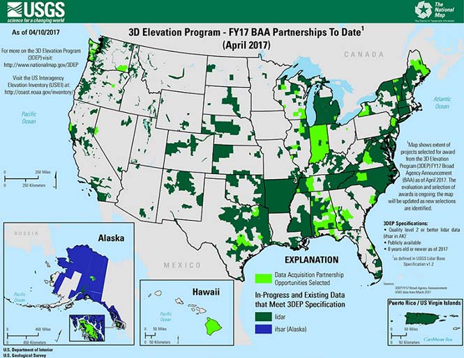
3DEP
Formally known as the 3D Elevation Program, this language was introduced as part of S. 1460 (“Energy and Natural Resources Act of 2017”) by Senator Lisa Murkowski of Alaska. This program is being created so that consistent elevation data, cultivated through many surveying and mapping sources including lidar, will be available for efficient design use throughout the American infrastructure.
While it currently does not have a single line item in any budget, the USGS Budget Summary lists its necessity in the Core Science Systems Program as part of the National Geospatial Program. This program is intended to provide high-quality topographic, geologic and hydrographic data nationwide to assist with further development of energy, transportation, drainage, emergency response and hazard mitigation.
As part of the 2019 President’s Budget, the USGS Green Book also lists having the entire nation covered by an ongoing lidar program by 2033, along with completing a significant amount of data collection by various means in Alaska by 2022, including high-resolution interferometric synthetic aperture radar (IfSAR) necessary for data collection in more difficult terrain.
The Green Book also lists high-resolution hydrographic data to support flood risk management studies, as the frequency of large scale flooding seems to be increasing substantially in more places than ever before. It also includes additional mapping data, programming and functionality for emergency personnel charged with oversight of public safety in times of crisis.
FAA reauthorization
The current FAA authorization bill expires on March 31. The biggest hang up holding up getting the bill reauthorized is privatization of the air traffic controllers, but there are rumors of tightening of UAV rules due to the rapidly growing use of the vehicles for business and personal use.
Surveyors are working with federal and state officials to help implement reasonable rules for use and coverage of the UAV as the field of surveying has been drastically affected by use of aerial vehicles. Many tasks that used to take days now take hours with increase accuracy, so the effects of the UAV will be seen for many years to come.
Digital Coast Act
One of the legislative acts that NSPS was a big part of in 2017 was Senate Bill 110, “The Digital Coast Act” which led to the introduction of the companion bill in the House as H.R. 4062. This Act will allow NOAA to perform the necessary actions to actively and effectively monitor all coasts (including the Great Lakes) by various means, including bathymetric and conventional survey methods. This will require services to be performed by public and private surveyors primarily with GNSS capability to provide NOAA with standardized information based upon established datum.
FLAIR Act
The Federal Land Asset Inventory Reform (FLAIR) Act of 2017 was introduced as House Resolution 2199 to help with creating a database of government property nationwide. The Government Accountability Office (GAO) has stated that the management of federal real property has become a “high-risk” item on its list of duties. Management of the number and value of properties has increased to a point that an overall dollar amount of federal buildings and land cannot be accurately determined.
How does the surveyor fit in with this issue? Simple. The U.S. government will need to upgrade its database of existing facilities through having them surveyed for asset management. Part of the requirements for providing these surveys will be completing the work in datums that will be following the geographical databases being designed to contain the parcel and building information. All this data will have geospatial information regarding parcel, address, utilities and functionality of the inventory, so providing the data with the sufficient attributes will become a key role for the surveyor. GNSS data collection will be at the heart of this monumental task.
Geospatial Data Act
As introduced in May 2017, the Geospatial Data Act (GDA) of 2017 is intended to jumpstart the nationwide initiative to develop and coordinate efforts to collect and maintain new datasets of elevation and infrastructure information. It is intended to improve and enhance federal geospatial activities to encourage state and local agencies to participate at the local level.
It is interesting to note, however, that the revised Geospatial Data Act was introduced by the same sponsors that did not include procurement procedures that follow the typical Brooks Act of quality-based selection, and instead relied on bid-based selection commonly found with suppliers. Both bills are being vetted by their sponsors and potential geospatial providers for clarity with ongoing debate going forward.
Hydrographic Services Improvement Act
H.R. 211 bring us the Hydrographic Services Improvement Act to provide NOAA with incentive and funding to standardize surveys desperately needed in waterway areas. Ongoing discussion continues this spring to determine sources of funding and priority of projects.
Infrastructure bill
February brought us the introduction of a significant infrastructure program aimed at improving roads, airports and bridges, with other major improvements across the country. This program is noteworthy in recognizing the need of current geospatial data and inventory of major infrastructure needs. The program sets forth the need for surveying, mapping and geospatial data for planning, design, construction, operations and maintenance for a multitude of projects nationwide. Much more will be discussed regarding the funding and priority of projects as the political year moves on.
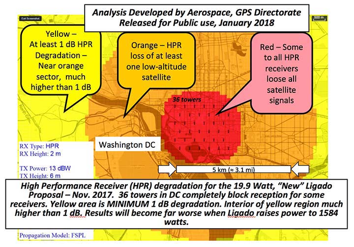
LightSquared/Ligado
Readers may remember when the original confrontation with LightSquared began in 2011, and the subsequent battle over the frequency ranges adjacent to the GPS bandwidth. The FCC gave LightSquared initial but conditional approval to move forward with terrestrial-based transmission for 4G cellular transmission for up to 40,000 land-based stations. Testing by private and governmental agencies through 2011 and 2012 proved that LightSquared would greatly harm GPS activity for both public and private use. Once exposed, the conditional FCC approval was rescinded and LightSquared retreated into the shadows…until now.
Reformed as Ligado, it has fresh investors and is making a charge into 5G technology with a revised game plan. While it is also looking to use other spectrums for communication, it once again is dangerously close to other current uses. Couple the proximity of adjacent bandwidth with the intense land-based signal versus a very weak satellite signal, there will be significant overriding by the new user. All of this is still being worked out through the FCC and the Department of Defense, so final resolution is yet to be seen.
IMAGES Act
The National Flood Insurance Program (NFIP), as part of FEMA, is looking to move forward with legislation introduced as Improvement of Mapping, Addresses, Geography, Elevations and Structures (IMAGES) Act (H.R 4905). This act intends to reform the NFIP program by utilizing new elevation data collected through the 3DEP program, which will be combined with other parcel attributes including addresses and structure types. This data will then be combined with refined floodway information to identify parcels that are more susceptible to damage caused by storms and flooding.
New legislation can be a good thing, but only if funding can be provided. This bill could provide a major upgrade to the flood mapping and insurance program, but it will hit a big snag with lack of monetary support. The proposed funding for FY2019 is $100 million, yet the project costs for the FY2018 budget is $178 million. This significant difference will make a large impact on the effectiveness of the program and proposed revamp.
Railroad reauthorization
NSPS has spent several years working with various legislators trying to find the right bill to insert language to require railroads to monument their routes before removing tracks. But with the recent accidents of various rail lines, the spotlight has been put on various factors that cause the incidents and how to eliminate their occurrence.
Positive train control (PTC) systems incorporate geospatial data collected through GNSS, lidar and conventional surveying means to work with operational systems to assess dangerous situations. Surveyors will need to be at the forefront of the necessary data collection so our efforts to continue lobbying for railroad funding will continue.
Net Neutrality Act
A political hot topic the surveyor doesn’t typically think about is net neutrality. Most people think they will be affected by lack of neutrality slowing down their home internet or streaming service, but for surveyors it will be a much bigger deal.
A remarkable number of surveyors and mappers use cellular data streaming to provide a connection to a positional correction service. The throttling of this data will effectively slow down the performance and quality of the positional data, leading to less reliability and productivity. It will also slow down the data interaction of office and field staff exchanging data and image files critical to project productivity and success.
So, when the call goes out to contact your federal representative to protect net neutrality, remember how it will affect your surveying business model and make that call.
How professional land surveying associations get it done
Many thanks to the countless hours put in by the NSPS Joint Government Affairs team, consisting of Committee Chair Pat Smith, NSPS Government Consultant John Palatiello, NSPS Federal Lobbyist John “JB” Byrd and NSPS Executive Director Curt Sumner. This group is constantly monitoring legislative action across the country as well as in D.C. and is quick to respond when action is needed on legislative issues. They do a tremendous job, yet not many see them in action. Hopefully all surveyors will continue to see and feel the benefits of their results.
As simple as the process is, the political world has gotten much more complicated as time marches on. From local municipal offices to Washington, D.C., getting things done through legislation has become a long process that takes patience and plenty of money to get your voice heard. Surveyors are no different than any other profession in that we must stay out in front of issues that affect our physical and business world. The important part is to stay informed and have a voice.
Let’s also remember those three fine individuals, memorialized on Mount Rushmore, who accomplished great things after their stints as surveyors, so anything is possible if we keep our voice in government.
Surveying has evolved into a highly technical professional with GNSS as a backbone method of data collection. With the U.S. government at the center of that technology, we need to make sure we, as the surveying practitioner, stays engaged.
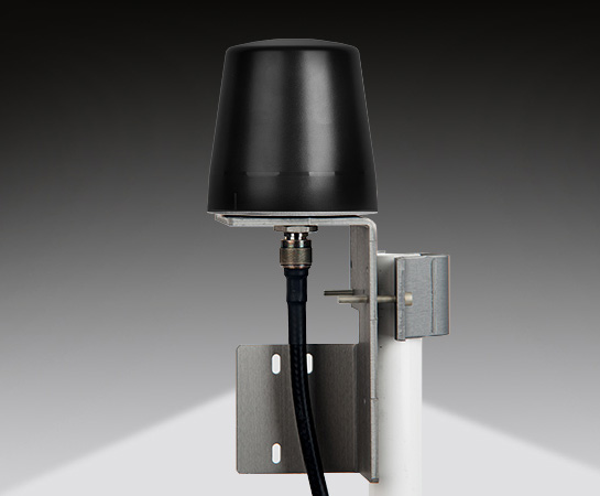
Designed primarily for applications such as homeland security, Spectracom’s 8230AJ antenna provides protection in high-interference environments where additional resilience is needed, such as communications networks, financial systems and power grids, the company said.
Orolia, through its Spectracom brand, said the antenna, Model 8230AJ, is a drop-in replacement for the company’s Model 8230. Its conical antenna pattern rejects interference from the horizon and is simple to mount using the same pipe supports, without new cabling. All that is required is a new bracket.
“Model 8230AJ is a high gain (40 dB) GNSS outdoor antenna covering GPS L1, GLONASS L1, BeiDou B1, Galileo E1, and QZSS L1,” said David Sohn, product manager at Spectracom. “It uses a three-stage low noise amplifier, a mid-section SAW, and a tight pre-filter to protect against saturation by high level sub-harmonics and L-band signals. It is designed especially for harsh environments, is IP67 rated, and improves resilience and protects against jamming and spoofing.”
According to the company, the AJ antenna rejects signals for the lower elevation angles – where most interference comes from – and only receives signals from the higher elevation angles where the satellites are. While this reduces the number of satellites the receiver will see, for timing applications only a few satellites are needed. Moreover, with multi-constellation receivers, an increasing number of satellites are available.
With the increasing prevalence of jamming and spoofing, industries with critical infrastructure must take measures against interference. GPS and GNSS in general have well-known vulnerabilities and limitations that require protection and mitigation: the signals are easily disrupted by unintentional interference from radio transmitters, they are extremely weak, cannot penetrate buildings and can easily be jammed, and civilian signals are not encrypted and can easily be spoofed.
The new anti-jam outdoor antenna is appropriate for anyone who uses a time server, including Spectracom customers who own a SecureSync, VersaSync or Netclock, according to the company.
Located in low, gently rolling hills just north of Indianapolis, Carmel, Indiana is one of the fastest-growing communities in the country. It has nearly tripled in population since 2000 and now numbers 91,000 inhabitants.
Considering the growth expected for 2017 and 2018, the City of Carmel needed a visual tool better able to manage the city’s expansion projects across several government departments.
After years of using low-resolution aerial imagery provided by the county, the City of Carmel realized it needed something better for analyzing and displaying accurate information.
The Carmel Storm Water Department turned to Nearmap to provide high-quality aerial images that are frequently updated to integrate with its existing applications, including ArcMap and ArcGIS.
Nearmap now supplies the city with high-resolution imagery that aids data accuracy, verifies customer claims, educates developers, enforces compliance, and prepares presentations for internal government meetings. As an unexpected bonus, since implementing Nearmap, the department has collected $60,000 more in revenue in 2017.
Shane Burnham, a GIS technician, and John Thomas, storm water administrator, both with the City of Carmel Engineering Department, will give a presentation on the city’s use of aerial imagery in a webinar on Thursday, January 18. The webinar is free, but attendees must pre-register.
Burnham provides GIS services for City of Carmel’s Engineering and Planning departments. He serves as departmental Cityworks Administrator and asset management specialist and has published custom GIS web applications during his career. Thomas focuses on impervious surface analysis using aerial imagery and GIS data in support of storm water administration and billing.
“Truth on the Ground is Best Seen from the Air: How aerial imagery is propelling government and commercial organizations to higher levels of operational efficiency” will also feature speakers from Black & Veatch, an engineering, consulting and construction company with more than 100 offices worldwide, specializing in infrastructure development in power, oil and gas, water, telecommunications, government, mining, data centers, smart cities and banking and finance markets; and from Nearmap, an international provider of high resolution aerial imagery.
Carmel Courthouse. (Photo: City of Carmel, Indiana.)
Carmel was named Number 1 among Niche’s “Best Places to Live in 2017”. Niche is a website that analyzes public data sets and reviews to produce rankings, report cards, and profiles for every K-12 school, college, and neighborhood in the U.S.
Advances in aerial imagery including high-resolution maps and a streamlined process to capture, manage and deliver imagery in the cloud is transforming the way governments and businesses operate. In this webinar, you will:
Learn about the latest advances in aerial imagery including how imagery is supporting a variety of government and business applications today.
See real-world use cases of imagery in telecommunication, engineering and city government to improve operational efficiency.
Understand how imagery can be used standalone and within GIS and CAD products.
See the latest demos of Nearmap imagery including vertical, panorama and oblique views.
Microsemi Corporation, a provider of semiconductor solutions, today announced its new approach to protecting critical infrastructure against GPS spoofing and jamming threats.
The BlueSky GPS Firewall is designed to provide security protection for GPS-delivered position, navigation and timing (PNT) data. It can be deployed in-line between any standard GPS antenna and stationary GPS receiver to provide protection against GPS signal incidents, both intentional or accidental, before they enter a GPS receiver system.
Microsemi is making BlueSky GPS Firewall Evaluation kits available in advance of its full production release, both in response to the growing number of GPS incidents and their potential threat to critical infrastructure, and to assist customers in rapid adoption.
BlueSky GPS Firewall filters the GPS signal in real time, removing anomalies before the signal is consumed by the downstream GPS receiver. This creates an intelligent and secure barrier against jamming and spoofing, and prevents the GPS receiver from being impacted by such incidents.
Deployment of the BlueSky GPS Firewall does not require any new cabling or alteration of the pre-existing antenna installation and is interoperable with standard GPS receivers. Additionally, the BlueSky GPS Firewall incorporates an Ethernet interface for remote management and monitoring and includes a secure web interface that any browser can use for configuration and set-up of the device.
The BlueSky GPS Firewall includes a broad range of data validation rules based on real, live-sky GPS threats, both intentional and unintentional. Similar to network security threats, new GPS vulnerabilities are on the rise and Microsemi is continuously tracking GPS signal manipulation including spoofing threats, jamming attacks, multipath signal interference, atmospheric activity and many other issues that can create GPS signal anomalies, disruptions and outages.
These advancements are incorporated into the software platform of the BlueSky GPS Firewall, which can be updated remotely using Microsemi’s TimePictra management system.
GPS Dependency
The dependency on PNT is increasingly important to critical infrastructure sectors such as telecommunications, energy, transportation, emergency services, financial services and enterprise infrastructure, and is mainly provided through GPS.
“Worldwide critical infrastructure dependency on unprotected GPS receivers is a serious security risk. These receivers are susceptible to jamming and spoofing incidents and the industry recognizes this as an increasing threat,” said Randy Brudzinski, vice president and business unit manager of Microsemi’s Frequency and Time division. “The vast number of GPS systems already in operation means a significant investment would be required if every system was to be replaced. Microsemi’s BlueSky GPS Firewall is a cost-effective and easy-to-deploy solution to protect GPS without requiring replacement of deployed GPS systems.”
Published best-practice documents by the Department of Homeland Security (DHS) Science and Technology Directorate (S&T) describe steps that can be taken to mitigate outages and disruptions with GPS reception. In alignment with these documents, Microsemi’s new BlueSky GPS Firewall provides critical infrastructure sectors with a first line of defense against GPS threats to help build out a secure, robust and resilient PNT platform for their infrastructures.
According to the 2017 GNSS Market Report, Issue 5, by the European GNSS Agency, professional market segments such as maritime, rail, telecom/utility/enterprise, surveying, aviation, agriculture and drones which use GNSS devices to operate their infrastructures, enable billions of people globally to benefit from them on a day-to-day basis—whether by enjoying the produce of sustainable and cost-effective agriculture, by using efficiently coordinated transport networks, or by leveraging on GNSS-synchronized telecommunications networks. The total installed base of GNSS devices in these professional segments was estimated at 14.4 million units in 2015 and is expected to grow to 97.8 million units by 2025.
Higher-Accuracy Positioning to Improve GNSS Network Performance and Reliability
Trimble has introduced version 3.10 of its Pivot Platform software, a modular solution for real-time GNSS infrastructure management, ranging from a single-base GNSS continuously operating reference station (CORS) to a full real-time network (RTN), serving thousands of end-users worldwide.
Version 3.10 provides improvements to network performance and office and field productivity. The new features and capabilities include:
Galileo support provides access to five GNSS constellations — GPS, GLONASS, BeiDou, QZSS and now Galileo — allowing end-users to expect improved positioning accuracy and fix performance from the 50 percent increase of accessible satellites;
GPS L5 support utilizes all available L5 third-frequency GPS observations to enable end users to further improve field productivity;
Code Bias Calibration client and server improvements provide a higher availability of network-modeled RTK corrections to allow field users to reduce dependency on station biases;
Sparse Network supports Galileo and BeiDou. Sparse Network, a Trimble technology, enables RTN operators to achieve the benefits of a full network-processed GNSS constellation even if the network is not fully covered with multi-constellation CORS.
Dynamic Station Coordinates (DSC) module improvements minimize the impact of erroneous reference station coordinates to improve system performance.
“Trimble continues to transform the way our customers manage their real-time GNSS infrastructure by making networks more robust and easier to manage,” said Mark Richter, director of marketing for Trimble’s Advanced Positioning Division. “Accessibility to the Galileo constellation and the addition of the L5 third-frequency observations in particular, makes Trimble’s Pivot Platform significantly more versatile to improve functionality and performance for end users in the field.”
Trimble Pivot Platform version 3.10 is available now from Trimble’s Distribution Network and Trimble Sales Representatives. Customers with a valid software maintenance agreement receive the new version at no additional cost.
Geographic data specialist Bluesky has secured funding from the United Kingdom’s innovation agency, Innovate UK, to investigate the potential of mobile phones for capturing accurate 3D spatial information.
Designed to reduce the costs of monitoring and managing essential infrastructure, such as overhead electricity cables, and mitigate the effects of potentially damaging vegetation, the Bluesky-led study will assess the feasibility of extracting 3D measurements from standard smartphone video footage.
Using specialist software and specially developed photogrammetric algorithms, it is possible to compute depth values for individual pixels within overlapping images taken from video to create dense 3D point clouds of an object or scene, Bluesky said.
Working in partnership with ADAS, an environmental consultancy, Bluesky will provide experience gained through previous data capture and management projects with electricity distribution network operator (DNO) companies in the UK and overseas.
The initial application of this innovative use of mainstream technology would be the accurate measurement of vegetation encroachment in the field for maintenance purposes. The company will also explore other applications of the solution in sectors such as forensics, insurance and emergency response.
World Market
DNO companies spend millions monitoring and maintaining clearance between trees and power lines, with the market potential in Europe alone estimated at £10 million per annum.
By using readily available mobile phone technology, Bluesky hopes to reduce this cost of overhead networks, both power and telecommunications, across the world, and provide managers with an easy-to-use and easy-to-update efficient audit trail.
The Pentagon’s Defense Advanced Research Projects Agency, better known as DARPA, has awarded Raytheon multiple contracts to research and develop technologies that will detect and respond to cyber attacks on the U.S. power grid infrastructure.
The contracts, which total $9 million, were awarded under DARPA’s Rapid Attack Detection, Isolation and Characterization Systems program.
“During the last two decades, industrial control systems have evolved so that most are now connected to the Internet, making them vulnerable to cyber attack,” said Jason Redi, vice president for the Raytheon BBN Technologies Networking and Communications unit. “A significant power disruption would have profound economic and human costs in the U.S, so our goals are to prevent attacks and to reduce the time required to restore power after an attack.”
Raytheon BBN will create technologies to enhance situational awareness by providing early warning of an impending attack and detecting adversary spoofing of power grid data collection and communication. These technologies will also maintain situational awareness in the immediate aftermath of an attack.
The company will also examine methods to maintain secure emergency communication networks in the aftermath of an attack. Raytheon BBN’s approach seeks to isolate affected organizations from the internet and establish a secure emergency network to coordinate power restoration without depending on external networks.
Raytheon BBN Technologies is a wholly owned subsidiary of Raytheon Company.
Broadcast Date: Thursday, October 29, 2015 On-Demand Available Until: Saturday, October 29, 2016 Moderator: Alan Cameron, Editor-In-Chief and Publisher, GPS World Speakers: Edward Powers,GNSS and Network Time Transfer Operations Division Chief U.S. Naval Observatory; Ron Holm, Marketing Manager
EndRun Technologies; Grace Xingxin Gao, Ph.D., Professor University of Illinois at Urbana-Champaign; Richard Foster, Ph.D., Sr. Business Development Manager, Microsemi Government Systems Microsemi Corporation Summary: Learn more about the current efforts behind – and changing demands to – keeping the nation’s timekeeping and synchronization infrastructure up to speed. We examined why that has become more critical than ever for the Internet of (Every)thing(s) and the nation’s economy. The panel also shed light on cutting-edge time transfer research, and dove into new applications and techniques for use in metrology, defense, communications and aerospace.
Trimble has introduced its latest smart antenna with an integrated multi-GNSS receiver for high accuracy and precise timing applications. The Acutime 360 smart antenna provides a pulse-per-second (PPS) output synchronized to UTC within 15 nanoseconds (one sigma).
The Acutime 360 is the latest in the Acutime line of products, which have been deployed in the field for more than 20 years. With a user friendly interface for communication, the GNSS smart antenna is light weight and easy to integrate with a host system. It is suitable for critical infrastructure including wireless networks and utilities.
The Acutime 360 GNSS smart antenna is built using the Trimble 360 technology platform for multi-GNSS systems, which includes support for GPS, GLONASS, BeiDou and is Galileo-ready. The Acutime 360 has tracking sensitivity of -160 dBm and an acquisition sensitivity of -148 dBm. The increased sensitivity translates into greater reliability and accuracy.
The Acutime 360 smart antenna uses a standard 12-pin connector and is footprint-compatible with previous generations of Acutime antennas. The Acutime 360 antenna is an ideal solution for precise timing and frequency synchronization for a wide range of applications including:
sync reference for wireless and small cell networks
utilities – smart grid
Supervisory Control and Data Acquisition (SCADA) systems
critical infrastructure
Designed for long-term reliability, the IP67 compliant Acutime 360 is corrosion-resistant and waterproof and has a rounded top that facilitates run-off from the elements. It weighs less than 6 ounces and offers an extremely cost-effective solution for adding GNSS reference to any application where ease of installation and long-term reliability is critical.
Once powered, the Acutime 360 automatically tracks satellites and surveys its position to within meters. It then switches to over-determined time mode and generates a PPS, outputting a time tag for each pulse. The smart antenna’s Time-Receiver Autonomous Integrity Monitor (T-RAIM) algorithm maintains PPS integrity.
The GNSS smart antenna can operate in extreme temperatures (-40°C to +85°C) and hostile RF environments typically encountered at wireless network transmitter sites. It requires less than 1 watt of power to operate and outputs the Trimble Standard Interface Protocol (TSIP) or industry-standard NMEA messages.
The Acutime 360 smart timing antenna is expected to be available in the second quarter of 2016 through Trimble’s Time and Frequency sales network.