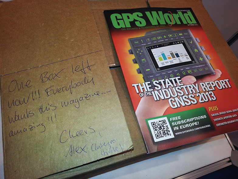
20 Years of INTERGEO
The world’s leading conference trade fair for geodesy, geoinformation and land management celebrates its 20th anniversary in the German capital, October 7-9.
The world’s leading conference trade fair for geodesy, geoinformation and land management celebrates its 20th anniversary in the German capital, October 7-9.
The annual Intergeo conference and trade fair, this year held October 8–10 in Essen, Germany, elicited three principal observations from the three GPS World staff who attended:
Like ION-GNSS+, Intergeo spans an industrial exhibit and a technical conference, but the emphasis in Germany is decidedly on the former.
The technical conference covers key topics from a geoinformational perspective: environment, climate, energy, disaster management, cartography, spatial data, land policy, geographic information systems (GIS), and satellite processes and geodesy. About 140 presentations in 40 subject areas drew 1,300 participants — slightly larger than ION-GNSS+.
But the real story here is the gigantic trade fair for geodesy, geoinformation, and land management, displaying GIS software and services, surveying equipment and accessories, data capture and processing, remote sensing photogrammetry, cartography, and much more — including a dizzying and frequently buzzing array of micro-UAVs.
These face less regulation Europe than in the United States, which has still to come to grips with the technology. Federal Aviation Administration rules are expected in 2015.
The 28,000 square-meter Intergeo exhibition space featured 505 exhibitors from 30 nations and drew an estimated 16,000 attendees from 80 countries — making it between eight and 125 times the size of the ION GNSS+ industry exhibit. Clearly, the German show has a different mission and a different mix of both exhibitors and attendees, spanning different bands of the GNSS application spectrum; and, its orientation is much more commercial.
Exhibitors at the two shows form sort of an old-fashioned Venn diagram: some exclusive to either show and some overlapping, appearing at both. Among the latter group were: JAVAD GNSS, Trimble, Hemisphere GNSS, Leica Geosystems, NovAtel, Septentrio, ComNav Technology, Topcon Positioning Systems, and Fraunhofer Institute.
Among GNSS companies showing in Essen but not in Nashville were Altus Positioning, AllSat GmbH, Carlson Software, CHC Navigation, Forsberg, Fugro Geospatial, and Hi-Target.
A final question proffers itself after three days amid this hubbub: Why is there not a North American show of this nature? The Esri User Conference comes closest, but it is vendor-specific. There would appear to be a niche for a 5,000–10,000 attendee tradeshow in this sector.
The Business section of the November 2013 issue of GPS World (Download the PDF).
Includes: Orolia to Supply Atomic Clocks for Galileo Satellites; Symmetricom Expands SyncWorld Program to Power Utilities; Product Showcase. Plus: NextNav and Broadcom Partner for Indoor Accuracy; Events.
Also: Show reports from ION GNSS and Intergeo.
When looking at geospatial technology, I like to use the analogy that GIS software is the engine and GIS data is the fuel. We have many choices of powerful GIS software engines (Esri, Intergraph, QGIS, GlobalMapper, MapInfo, etc.). That technology remains relatively unchanged. Before the software vendors harp on me, yes, I get that new bells and whistles are added to software every year to enhance software functionality. Yes, maybe there’s a new database technology that indexes massive databases significantly faster. Yes, maybe there’s a new software tool that makes generating 3D visualizations or augmented reality much easier and faster. But just like your automobile, motorcycle, train, airplane, etc., they all need fuel to run. Data is the fuel.
The analogy doesn’t fit perfectly. After fossil fuels are used once, they are not reusable. Obviously, that’s not the same for GIS data. Some GIS data, like street data, is used daily over and over again by millions of people around the world in their Garmin, TomTom, and Magellan auto navigation units. However, in the fossil-fuel world, engines and fuel are matched reasonably well. In the geospatial world, the engines and fuel aren’t matched. The GIS fuel (data) is far behind the engine (software). In other words, GIS software is starving for data. There are so many applications for GIS yet to be realized, and vast majority of the unrealized apps are due to the lack of data.
For example, imagine carrying your iPad (or other tablet) in the street and pointing it down at pavement. Imagine, on the screen of your iPad, being able to “see” all of the infrastructure underneath the pavement such as water lines, sewer lines, and communications lines. What’s keeping those types of apps from being deployed today? The answer: the lack of accurate geospatial data.
The lack of geospatial data is no more apparent than at the 2013 Esri International User Conference in July and the Intergeo conference in Germany earlier this month.
In the exhibition areas, three trends were clearly apparent:
1. Mobile devices
2. UAVs
3. High-precision GNSS receivers
Clearly, all three of these are related to collecting GIS data.
Following are some comments and photos of each trend.
A few short years ago, mobile devices suitable for GIS data collection were a specialty item, and we had a few limited choices. Ever since the smartphone explosion and Apple introducing the iPad, it’s been mobile devices galore. A tremendous number of consumer mobile devices have been introduced. Most have failed, but the trend has generated a tremendous amount of R&D effort that manufacturers have leveraged to make industrial mobile devices for the geospatial community, such as the following:


Most, if not all, of these devices are designed and manufactured in China.

UAVs
There’s no denying that UAVs are going to play a large role in geospatial applications. In some geographic regions of the world, they are already being deployed for mining, agriculture, accident reconstruction and other mapping applications. The low-cost and and quick, convenient deployment make it a very attractive technology for time-sensitive and cost-sensitive applications that require imagery.
In the U.S., it is illegal to use UAVs for commercial applications unless you have a Certificate of Authorization from the Federal Aviation Administration (FAA), which are only granted to some universities and some government agencies. President Obama ordered the FAA to generating guidelines for integrating the use of commercial UAVs into the U.S. airspace by 2015. For the latest FAA progress on matters regarding UAVs, you can visit this FAA web page.
The current FAA rules are a bit odd. In the U.S., you are allowed to fly “hobby” UAVs up to 400 feet above the ground if you’re at least 1/4 mile away from an airport. If you take that same UAV and abide by the same restrictions as hobbyists, but use it for commercial purposes, it’s illegal. Take a look at this article by NBC News.


I’ve been writing about this for awhile, but it’s worth mentioning that RTK GNSS receivers are getting cheaper and cheaper. Whereas in the past, there have only been a handful of RTK GNSS receiver vendors, there are now at least twice as many as before, and increasing every year. This is good for the user community because it increases competition. The result is better products at lower prices. This trend will continue.


Last week, I was a guest along with David Doyle (retired NGS Geodesist) on the NSPS Radio Hour discussing a variety of GNSS-related items such as the U.S. federal government shutdown and LightSquared. A recording of the radio show is available in MP3 format. You can listen or download it here.
Thanks, and see you next time.
Get the latest news by following me on Twitter at https://twitter.com/GPSGIS_Eric.
Photos: Eric Gakstatter


Juniper Systems has announced the availability of a new rugged handheld, the Archer 2. With radical improvements over the first generation Archer, the Archer 2 promises better overall performance with an astonishingly bright display, an extra-long battery life, enhanced GPS capabilities, and rugged IP68 construction.
Juniper Systems will be showcasing the Archer 2 at the Intergeo 2013 conference from October 8-10 in Essen, Germany.
According to the announcement, the latest generation handheld incorporates several new technological advancements. Sporting a custom 4.3-inch Illumiview high-visibility display, the Archer 2’s screen brightness has been well received by reviewers. Its battery features a unique technology inspired by the technology used in hybrid car batteries to prevent excessive battery drainage in low temperatures. Referred to as Overtime Technology, this Archer 2 super battery will last 20 hours and up on one charge.
The new device is the first Juniper Systems handheld to feature a capacitive touchscreen for improved response and ruggedness. The Archer 2 also includes a glove-friendly numeric keypad for rapid data entry, a feature which many Juniper Systems customers highly value. Like other Juniper Systems handhelds, the Archer 2 is built to very strict standards at its ISO 9001:2008-certified facility, having been tested to MIL-STD-810G and given a top IP68 rating for dust and water.

“We have been looking forward to the release of the Archer 2 for some time,” said Rob Campbell, CEO at Juniper Systems. “We have taken special care in addressing the needs of customers in the design of the Archer 2. It is a product of utmost quality, and the excellent reviews we have received on our Archer 2 beta units have made us very optimistic that the Archer 2 is going to meet our customers’ needs exceptionally well.”

Trimble announced today several enhancements to the Trimble R10 GNSS Surveying System designed to drive field productivity to a new high. With sophisticated tilt-compensation technology, CenterPoint RTX correction service support, and updated field and office software, the R10 platform demonstrates Trimble’s commitment to driving improved surveying productivity.
The announcement was made at Intergeo 2013, being held October 8-10 in Essen, Germany.
“Innovations in techniques such as our tilt compensation technology can have a pervasive impact on the everyday surveying experience,” said Elmar Lenz, business area director of GNSS Solutions for Trimble’s Geospatial Division. “With our innovative approach to total surveying workflow, Trimble is redefining the way surveying work is done.”
The Trimble R10 is now augmented to further speed GNSS field work. With its new internal tilt-compensation, Trimble SurePoint technology takes field efficiency to the next level. The system will automatically adjust for pole-tilt up to 15 degrees from plumb, saving time and reducing fatigue. With tilt compensation, surveyors can now utilize GNSS in more situations and with 100 percent measurement traceability.
In addition, Trimble introduced its high-accuracy correction service, CenterPoint RTX, into the geospatial market with support in the Trimble R10. Powered by Trimble RTX technology, CenterPoint RTX is a subscription service that delivers real-time 4 centimeter (1.5 inch) or better corrections via satellite directly to the receiver without requiring the use of a base station, VRS network, or investment in additional hardware.
Both Trimble Access field software and Trimble Business Center office software have been updated to streamline data flow and automate data processing. Faster in the field and more flexible in the office, Trimble’s premium GNSS surveying system enhances the entire surveying workflow.
The updates to Trimble R10 GNSS System, CenterPoint RTX service support, Trimble Access version 2013.40 and Trimble Business Center version 3.10 are expected to be available in the fourth quarter of 2013 through Trimble’s Geospatial Division distribution network. For current R10 users, the tilt-compensation feature and CenterPoint RTX support will be available through a free firmware update.

Carlson Software has introduced a new and improved version of its affordable Qmini data collector. The rugged, but lightweight Qmini2 provides fast processing, yet fits comfortably in one hand.
Carlson also launched the Carlson MINI2 data collector, which is more rugged, fast, and reliable than its predecessor. It comes with a numerical keyboard for easy coding of points.
Both products were introduced at Intergeo, being held October 8-10 in Essen, Germany.

The Qmini2. Weighing 11 ounces (315 grams), the Qmini2 includes a 5 megapixel camera and has a 3.7-inch (480 x 640) sunlight-readable display and comes with a stylus for ease of use. Other specifications include:
The Qmini2 comes with two batteries, a U.S. wall charger, and a soft carrying case. It may be purchased with Carlson’s SurvCE data collection software on board, or with Carlson GIS360, which uses both GIS and surveying technology in the field to collect data. For crash or crime reconstruction, The Qmini2 may also be used with Carlson’s CSI Mobile software.
For more information or to see the Qmini2 in action, stop by the Carlson Stand #3.097, Hall C, or outdoors at #100 at Intergeo, Oct. 8-10 in Essen, Germany.
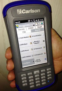
The MINI2. Manufactured to Carlson’s exacting specifications by Juniper Systems, the MINI2 has an extra-large 800 × 480 TFT display for easy viewing of survey data and comes with a fast 1.0-GHz processor. It comes with an integrated 3G modem, 5-megapixel camera, and GPS/GNSS module.
Its scratch-resistant, touchscreen display is highly readable in both low light and glaring sunshine, providing a sharper image together with notable durability in tough conditions. With a dustproof and waterproof rating of IP68, the Carlson MINI2 also meets the MIL-STD-810G military standard.
The Qmini2 will be available for purchase from your local dealer on November 1.
Both products can be viewed at Intergeo Stand #3.097, Hall C, or outdoors at #100. at Intergeo.

Arithmetica will be demonstrating Pointfuse at Intergeo, which is being held this week in Essen, Germany.
Pointfuse is a powerful modeling engine that has been created to give professionals a fast, precise and flexible way of turning vast point cloud data sets (whether derived from LIDAR or photogrammetry) into high-fidelity vector models, the company said.
Replacing painstaking and costly manual modeling, Pointfuse uses advanced techniques at the interface of mathematical optimization and computational statistics to automatically and rapidly convert point clouds into accurate vector models that can then be manipulated using any industry-standard CAD system.
Pointfuse is fully mobile compatible, and can process data from mobile scanners as easily and quickly as from terrestrial or airborne systems. Results can be output and used on standard handheld mobile devices, making it useful for creating and viewing highly detailed models in the field.

The software will also fully automate extraction of features from point cloud data, allowing the intelligent recognition, measurement and cataloguing of objects and built environments, and other forms of extracted knowledge.
George Skrobanski, chief technical officer of Arithmetica, explains the significance of this development. “Achieving the automatic extraction of features from point cloud data has been the Holy Grail for the industry. Pointfuse uses its proprietary technology to provide true automation and we believe this changes the game.”
At Intergeo, learn more at Arithmetica’s booth (Hall: 3 – Booth: D3.046).

Orbit GeoSpatial Technologies will be presenting the Clearance Checker for Mobile Mapping at this year’s Intergeo, being held this week in Essen, Germany.
“The Clearance Checker is an automatic detection tool that uses any mobile mapping lidar data to check clearances in height and width over any designated trajectory,” said Peter Bonne, vice president of business development and senior product manager at Orbit GT. “With the Clearance Checker, a vehicle contour of any designed size, is virtually driven through the point cloud over a chosen trajectory. Any collision or near-collision is automatically detected and listed for reporting, interpretation and subsequent actions. This tool is a must have for all rail- or tramway exploitation, oversize transport planning, and indeed every road and railroad maintenance or improvement project. This tool is an add-on to the Mobile Mapping Asset Inventory solution and is the first in a range of automated and semi-automated detection tools to be made available in shortly.”
Disy Informationssysteme GmbH will present GIS 2go at Intergeo 2013, being held this week in Essen, Germany. GIS 2go transfers maps from ArcGIS Desktop to an iPad or Android tablet. With the associated app, users can access their own maps without a network connection while they are on the road.
Intergeo is the world’s largest conference and trade fair for geodesy, geoinformation and land management. From October 8-10, visitors to stand D1.045 in hall 1 can experience GIS 2go live and meet with experts and developers in person.
GIS 2go allows maps to be taken along with the user, from Esri’s ArcGIS Desktop to a tablet (iPad or Android). With the GIS 2go Add-in, the data selection, the map export and the re-import are controlled via the cloud in ArcGIS Desktop. On the tablet, the “Cadenza Mobile GIS 2go App” allows access to the maps with all feature data — be it with or without a network connection. Even graphic notes and media created on the go are taken over into ArcGIS Desktop.
On the tablet, users can move interactively on the map; display feature attributes; add points, lines and areas with the graphic notebook; or track via GPS; augment the map with photos and audio/video clips or simply use text to comment on it. The information recorded remotely will be imported later into ArcGIS Desktop and taken over into the data storage.
In step with the path of the latest technologies in three dimensional laser scanning and photogrammetry, Gexcel Srl has released the new version of JRC 3D Reconstructor 2.9.1 with a special focus on UAV and drone platforms.
Gexcel Srl is attending Intergeo, taking place this week in Essen, Germany. Gexcel is using the event to introduce new 3D software tools and solutions focusing on the most recent release of the JRC 3D Reconstructor software for Unmanned Aerial Vehicle (UAV) and drone platforms.
UAVs and drones can quickly and cheaply capture georeferenced high-resolution images, Gexcel said. Third-party software typically produces GeoTIFF global images and 3D point clouds of the investigated area. These ingredients can be easily managed in JRC 3D Reconstructor to merge the GeoTIFF global image color over the point cloud and produce a 3D HR texturized point cloud and 3D HR texturized mesh models, Gexcel said.
Using JRC 3D Reconstructor, all the volume calculations, cross sections, cut and fill, crests and toes, and isolines can be created with a greater accuracy, because of real color state processing. This new feature emphasizes the importance that JRC 3D Reconstructor gives to the color information. It is considered as a most powerful tool for detailed geotechnical and geological investigations.
For a video, go to https://vimeo.com/75386387.
Gexcel Srl also announced the launch of its new Point Cloud Streaming Service based on a web application. The service allows to upload point clouds generated using Gexcel R3 or the new Gexcel R3 streaming software to a remote server. Gexcel R3 can import data directly from the most common point cloud data formats, E57 included. Massive point clouds loaded in the service servers can be visualized and navigated in Chrome or Firefox using a standard 64-bit PC.
The service is designed to improve the ability of users to visualize the results of 3D laser scanning surveys with collaborators, clients and web community. The 3D point clouds can be also customized to include proprietary company logos and project banners.
