On Jan. 6, HERE Technologies, a location data platform, announced its collaboration with Amazon Web Services (AWS), a leading cloud platform. This collaboration will deliver improved performance for indoor and outdoor positioning capabilities, enabling AWS third-party developers to track and manage internet-of-things (IoT) devices.
HERE Positioning enables developers to switch between different localizing technologies, and it does rely exclusively rely on GNSS for the location of a device or application. This is being integrated with the AWS IoT Core Device Location feature, which makes it possible for developers to track and manage IoT devices without relying on GNSS/GPS hardware.
The integration of the two platforms makes devices and applications location-aware globally with a high-level of positioning accuracy and data security.
HERE Positioning maintains a global database of more than 200 million Cell-ID and 5.6 billion Wi-Fi access point locations, which is updated and populated through machine learning algorithms. It supports a variety of device types, regardless of operating system, using Wi-Fi and cellular networks.
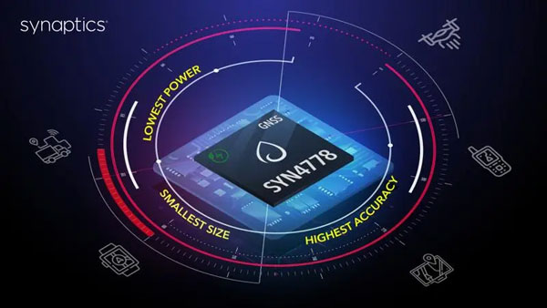
On Jan. 3, Synaptics released the SYN4778, a small, low power, accurate GNSS integrated circuit for Internet of Things (IoT) devices. SYN4778 is designed to extend battery life, reduce product size, and enhance performance of advanced location-based services for IoT devices, including wearables, mobile accessories, asset tagging and tracking systems, UAVS and transportation navigation.
SYN4778 includes advanced multi-path interference mitigation using L5 band signals from GPS, Galileo, BeiDou, NAVIC, SBAS, and Quasi Zenith Satellite System (QZSS). The chip also uses L1 satellite bands to reduce the time to first fix, as well as the power consumed, improving end-user experience, and enabling product developers to add additional functionality and features to their IoT devices.
This GNSS chip includes LTE jamming and signal filtering, and continuous — highly parallel — search and track of all GNSS channels for greater positioning accuracy for LBS applications, specifically in urban environments. Additionally, it offers support for multiple operating systems and third-party software to enable a broader range of application-optimized IoT devices.
SYN4778 is currently only available to select customers.
NextNav Inc., a GPS and 3D geolocation company, has acquired Nestwave SAS, a privately held company specializing in low-power geolocation.
The acquisition was completed Oct. 31 for $18 million.
NextNav is based in McLean, Virginia, and Nestwave is located in based in Neuilly-sur-Seine, France. Nestwave provides advanced geolocation solutions to internet of things (I0T) modem and digital signal processor vendors and end IoT users.
Nestwave will adopt NextNav’s name and be integrated into existing TerraPoiNT engineering and technology efforts, with all Nestwave employees remaining with the company. Nestwave CEO Ambroise Popper will become NextNav’s vice president and general manager in France and is joining NextNav’s executive leadership team, while Nestwave CTO and Founder Rabih Chrabieh will serve as vice president of engineering.
The combination of NextNav’s technology with Nestwave’s LTE/5G capabilities will allow NextNav to intelligently combine signals from existing terrestrial LTE/5G networks with its own highly synchronized TerraPoiNT system to deliver near nationwide resilient 3D position, navigation and timing (PNT) capabilities that contribute to dramatically lower deployment costs.
The company serves markets including timing for critical infrastructure, aviation, automotive, IoT and other mass market applications sooner.
“The acquisition of Nestwave presents a unique opportunity for NextNav to optimize further the use of its existing spectrum bandwidth, while contributing to a drastic decrease of our TerraPoiNT system’s future capital and operating expenditures,” said Ganesh Pattabiraman, NextNav co-founder and CEO.
“By leveraging Nestwave’s unique technology and ambient LTE/5G waveform, NextNav can gain significant spectral efficiency, accelerate the availability of resilient PNT and release the underlying spectrum’s capacity for additional data-oriented services. An LTE/5G waveform also enables broader penetration of NextNav’s applications and technology across the handset and device ecosystem for all of its products and target markets,” Pattabiraman said.
Pattabiraman continued, “Nestwave brings not only a physical presence in Europe, but also a team of professionals who have established strong relationships with European Union representatives that will be beneficial as we continue active conversations with government officials in the United States, Europe and globally over GPS/GNSS resilience.
“The transaction is not expected to materially increase the company’s operational cash burn, and the lowered capital requirements will enable us to quickly scale our GPS resiliency capabilities in both the United States and global markets sooner than previously anticipated.”
Vodafone and Topcon Positioning Group are developing a European precise positioning system, Vodafone GNSS Corrections, that will locate Internet of Things (IoT) devices, machinery and vehicles with a greater degree of accuracy than using individual GNSS.
Vehicles, scooters and robotic lawn mowers can be securely monitored in real time to within a few centimeters when connected to Vodafone’s global IoT network.
Vodafone GNSS Corrections will use technology from Topcon, which corrects inaccuracies from navigation satellite signals. Location accuracy is improved from a few meters to centimeters using Topcon’s dense European network of thousands of GNSS reference stations, especially when vehicles and devices are fitted with suitable antennas and receiver equipment.
Vodafone will offer a singular module configuration that can extend across national borders.
Vodafone is inviting select customers to join pilot customer trials in Germany, Spain and the UK, which will begin this month. The companies aim to test the service using a wide variety of devices connected to Vodafone’s global IoT network — one of the largest with more than 150 million connections — and its pan-European network covering 12 countries.
Pinpoint accuracy is critical to the mass adoption of vehicle-to-anything (V2X) technology used for driverless vehicles, autonomous machinery and robots. For example, e-bike riders could use Vodafone GNSS Corrections to provide details of their exact location and then alert other road users of their presence.
Vodafone GNSS Corrections also supports Vodafone’s efforts to improve V2X location accuracy, especially when sharing trusted data to help prevent unnecessary accidents and fatalities on Europe’s roads. As such, Vodafone is offering precise positioning as a complement to Vodafone’s new Safer Transport for Europe Platform (STEP) which allows entities to communicate with each other where no line of sight exists. Unveiled in March 2022, STEP has been successfully tested in Germany and the UK and will be made available via Vodafone Automotive and third-party apps later this year.
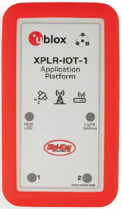
Featuring the full gamut of u-blox technologies and services, the XPLR-IOT-1 enables end-to-end proofs of concepts for IoT products and applications
The u-blox XPLR-IOT-1 IoT explorer kit. (Image: u-blox)
U-blox has announced the u-blox XPLR-IOT-1 IoT explorer kit, an all-in-one package to test, evaluate and validate applications for the internet of things (IoT).
The board hosts an ultra-low-power MAX-M10S positioning module capable of concurrently tracking four GNSS constellations, delivering highly reliable location data wherever GNSS coverage is available.
Integrating all relevant u-blox technologies and services into a capable prototyping platform with a vast selection of sensors and interfaces as well as cloud connectivity, XPLR-IOT-1 makes it easier to explore the potential of IoT applications.
The increasing complexity of IoT devices, which often require satellite-based positioning, Bluetooth low energy, Wi-Fi, and cellular connectivity via, for example, LTE-M is raising the importance of prototyping and validating ideas before bringing them to production. This trend is driving demand for multifunctional application boards like the u-blox XPLR-IOT-1 over evaluation kits (EVKs), intended to comprehensively test a product’s entire feature set.
Prototyping platform
The XPLR-IOT-1 gives users everything they need to prototype low-power IoT use cases such as logistics container trackers, industrial automation, sensor-to-cloud applications, and fleet management solutions. Besides the MAX-M10S positioning module, the board has a u-blox NORA-B106 Bluetooth LE 5.2 radio module that doubles as its main MCU, hosting the application software and controlling the other modules.
Other modules include a u-blox SARA-R510S for LTE-M and NB-IoT cellular connectivity with built-in cloud security, as well as a u-blox NINA-W156 for 2.4 GHz Wi-Fi.
The hardware is complemented by a broad selection of sensors commonly used in IoT applications, including accelerometers and gyroscopes, a magnetometer, and temperature, humidity, pressure and ambient light sensors. A power-on switch, LEDs and user buttons make it easy for users to interact with the device.
The NORA-B106’s powerful Arm Cortex M33 MCU is solely dedicated to running the application software. Clocked at 128 MHz, with 1 MB of embedded flash and 512 kB of RAM, and 8 MB of external flash memory, it offers a solid foundation for development of highly capable solutions.
Integrated antennas for featured technologies, a USB interface and USB charging, a Sparkfun Qwiic I2C connector, and a debug interface contribute to a smooth product development experience, u-blox said.
Native support for u-blox services
The XPLR-IOT-1 offers engineers an easy way to start working with u-blox’s services offering. Included with the kit is a trial of MQTT Anywhere, which delivers ultra-low power by communicating data between the device and the enterprise using the MQTT-SN (MQTT for sensor networks) protocol.
Tracking applications with the most stringent power requirements such as freight container trackers can realize four times longer battery life with u-blox’s positioning in cloud service, CloudLocate, while the CellLocate mobile-network-based location service extends tracking beyond the reach of GNSS signals.
A starting point for commercial end-products
Developers working with XPLR-IOT-1 can use code from u-blox’s ubxlib GitHub repository, a library of software examples for key use cases, to speed up the prototyping of solutions, which can range from wireless sensor networks to indoor and outdoor tracking solutions to industrial or smart building gateways.
Because all hardware design files, software, smartphone app, and online dashboard source code are shared, the XPLR-IOT-1 can also serve as a starting point for commercial end-product design.
“The XPLR-IOT-1 is fully geared towards rapid development, testing, and validation of IoT solutions,” said Pelle Svensson, senior principal, Product Strategy Short Range Radio, u-blox. “Offering a single platform to develop a variety of IoT use cases, the versatile explorer kit reduces the expertise required for hardware, software, and service integration and code development.”
Once launched in June 2022, the XPLR-IOT-1 will initially be sold via Digi-Key.
The commercially available L5-only GNSS solution includes machine-learning algorithms to leverage increased L5 signal-ranging precision in challenging signal conditions.
OneNav has announced performance results from field testing its latest pureL5 customer evaluation system (CES) software in both open-sky and challenging signal environments.
The patent-pending oneNav GNSS system, including a custom array processor and a library of machine-learning algorithms, demonstrated consistent sub-meter accuracy and rapid time-to-first-fix (<2 sec) in open-sky testing.
In very challenging urban and deep urban canyon environments, the pureL5 CES field-test equipment outperformed the commercial precision L1 GNSS unit against which it was compared, demonstrating tracking of satellite signals as weak as –160 dBm.
The oneNav system was able to acquire directly and track L5 signals in all environments with no L1 receiver present, greatly simplifying the RF front end and antenna subsystem and making the pureL5 solution suitable for space- and power-constrained mobile and internet of things (IoT) devices requiring reliable high performance.
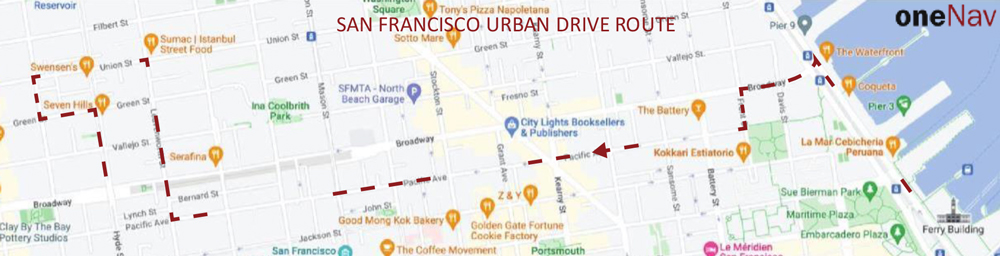
Results of a representative urban drive test route are shown below (the map describes the route driven). During this test, the CES and the commercial precision L1 receiver were both connected to a common antenna, fixes were taken once/second, and the results were compared to a common ground truth position. On average, the oneNav system demonstrated a 55% improvement in accuracy over the precision.
Image: oneNav
OneNav’s family of algorithms improves pureL5 system performance by predicting whether the received signal is line of sight (LOS) and correcting non-line-of-sight (NLOS) signals to increase the number of measurements available for accurate positioning.
The pureL5 algorithms characterize signal and multipath environments. Accordingly, algorithms developed in one deep urban area can be used to mitigate multipath in areas geographically different, but that present similar multipath signatures. This obviates the need for field-test teams to collect data in thousands of urban areas around the globe.
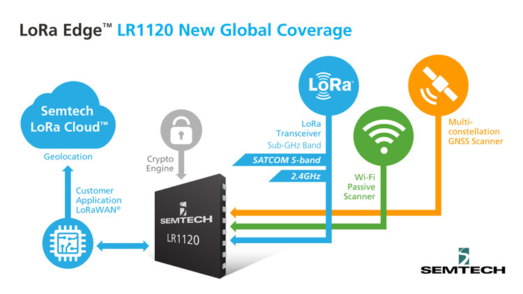
The new LoRa Edge LR1120 enables satellite-based networks and simplifies terrestrial network interoperability
Image: Semtech
Semtech Corp. has added multi-band capabilities to its LoRa Edge device-to-cloud geolocation platform.
The LoRa Edge LR1120 allows for direct satellite-connected internet of things (IoT) applications in supply-chain management and logistics with seamless low-power geolocation on a global scale, the company said.
“Semtech’s LoRa is targeting track and trace challenges faced by the logistics industry today with a geolocation IoT platform adapted to global transportation and mass-scale asset management,” said Marc Pégulu, vice president of IoT product marketing for Semtech’s Wireless and Sensing Products Group. “With the launch of multi-band LoRa support, coupled with LoRa Cloud services, it has never been easier to expand ubiquitous IoT connectivity and geolocation globally.”
With LoRa Edge LR1120, intercontinental logistics companies can leverage highly integrated, ultra-low-power trackers with enhanced interoperability, more versatile connectivity for a simpler operation, and global mobility across multiple regulatory regions, Semtech said. Additionally, the possibility to offer a low-power and low-cost sensor with satellite connectivity unlocks a multitude of use cases in infrastructure monitoring, agriculture and environmental monitoring that require deployment in remote areas, which tend to be capital intensive.
“Combining LoRa with small, relatively low-cost LEO satellites will change the game for LoRa and IoT,” said Christopher Taylor, director, RF & Wireless with Strategy Analytics. “Adding satellite communication capabilities in the S-band to LoRa can help replace aging SCADA monitoring and opens up new applications and markets, especially in remote regions. So far, LoRa has attracted the interest of several satellite companies including EchoStar and Lacuna.”
Key Features of LoRa Edge LR1120:
multi-band LoRa capability (sub-GHz, 2.4 GHz and licensed S-band for satellite) and multi-technology geolocation using GNSS for outdoor and Wi-Fi for indoor, as well as areas where satellite coverage is poor
LoRa Cloud geolocation solver, which transfers the location processing workload from the device to the cloud, making “deploy once” battery life possible
MetaGeo has launched a geographic information system (GIS) platform to enable organizations of all sizes to host, analyze, find and share 3D map datasets among any internet-capable devices.
The platform processes location-based map or sensor data from the real world, combines it into a single 3D virtual environment, and streams it to any device or mapping platform.
The affordable and easy-to-use platform can load data from multiple sources: satellites, drones, mobile devices, public and crowdsourced repositories, internet of things (IoT) sensor data, 3D models and topographic maps.
The data is then processed by the MetaGeo platform into a 3D world and streamed to any internet-connected device, enabling live collaboration between the office and field via mobile or AR device. A plug-in software development kit (SDK) allows for third-party tools to scale and fit user needs.
Applications include academia, architecture, engineering, construction, energy, natural resource management, environmental monitoring, utilities and public safety. Uses include planning and managing construction sites, organizing layouts of events, creating maps for public safety, and visualizing inspection imagery from drones and mobile devices.
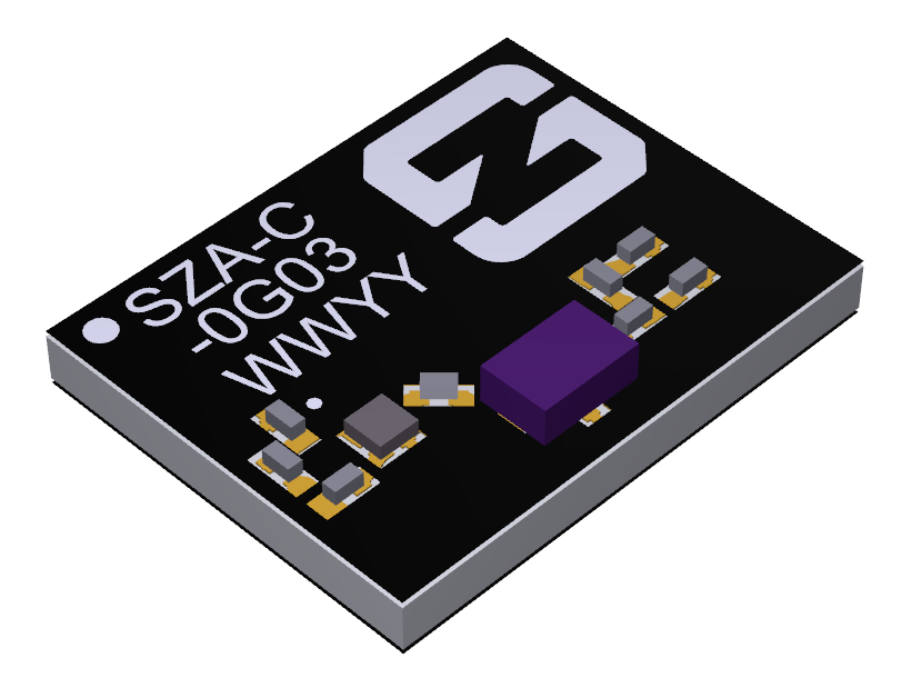
Antenna company Synzen Precision Technology has teamed up with Next Big Thing AG (NBT) to produce the sensor-based LTE-M/NB-IoT development platform Prometheus, which promises fast cellular internet of things (IoT) prototyping.
The PROXIMA GNSS antenna will be part of the Prometheus platform. (Photo: Synzen Precision Technology)
Prometheus is an IoT sensor-based development platform designed to simplify prototyping and speed time to market for developers of IoT and cloud-based solutions. The latest platform showcases Synzen’s expertise in GNSS and LTE 4G antenna solutions when combined with the Nordic nRF9160 module.
The building blocks enabling the mobility and IoT revolution are “always-on” connected 4G cellular and accurate and reliable GNSS solutions, regardless of the operating environment, Synzen said. Prometheus provides 4G connectivity combined with high-performance GNSS positioning solutions.
For the Prometheus platform, NBT chose the low-power FR4 active GNSS solution. “The selection of our latest PROXIMA low-power active solution in an FR4 package helped enable a fully certified solution optimized for low power consumption over the full industrial temperature range of –40 to +85 degrees centigrade,” said Chris Tomlin, Synzen technical director.
The PROXIMA GNSS SMD active antenna includes an amplifying front end to boost the signal as well as provide out-of-band filtering to prevent receiver saturation.
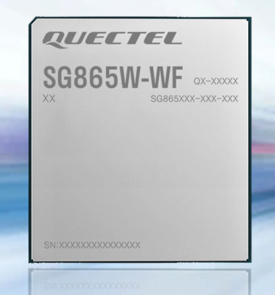
Quectel Wireless Solutions has launched the SG865W-WF, a new generation of flagship Android smart module. The module is equipped with Qualcomm’s QCS8250 system-on-chip (SoC), which offers powerful performance and rich multimedia functions to meet industrial and consumer artificial intelligence IoT (AIoT) scenarios.
Quectel made the announcement at the Consumer Electronics Show (CES) taking place this week in Las Vegas.
With various peripheral interfaces such as dual USB, multiple PCIe and UART, the product can seamlessly integrate with cellular and GNSS modules such as Quectel’s EC20 LTE module, and the RG500Q 5G module, allowing customer terminals to be connected flexibly to 4G/5G networks and achieve faster and more accurate positioning.
The SG865W-WF module will accelerate the efficient deployment of high-end AIoT applications such as video conferencing, cloud gaming, digital signage, unmanned aerial vehicles (UAVs), robots and smart retail.
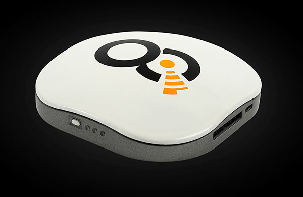
OQ’s dual-mode satellite-cellular IoT terminal can collect data from more than 1,000 sensors, has built-in GPS, and supports 5G NB-IoT, GSM, LTE-M and bi-directional satellite links. (Photo: OQ Technology)
5G satellite operator OQ Technology has successfully completed the in-orbit commissioning (IOC) of its Tiger-2 nanosatellite, and is ready to begin customer demonstrations. The company will start commercial services for “latency-tolerant” low-power devices in 2022.
OQ Technology started the IOC phase on Aug. 15, conducting operations to verify the performance of the satellite’s payload, which worked flawlessly on both uplink and downlink.
OQ also tested and calibrated its terminals in different fixed and mobile environments in the desert and for indoor usage. During tests, OQ was able to send the terminal’s location, as determined by its internal GPS receiver, to the satellite from inside a fast-moving car without having a direct line of sight to the sky.
When buried in desert sand, the terminal still sent signals to the satellite, making it suitable for many agricultural applications.
Over the next few years, OQ Technology is planning to launch a constellation of 72 satellites, providing 5G internet of things (IoT) and machine-to-machine communication. Its “cell-tower inside the satellite” technology is designed to provide real-time global connectivity with reliable low latency communication.
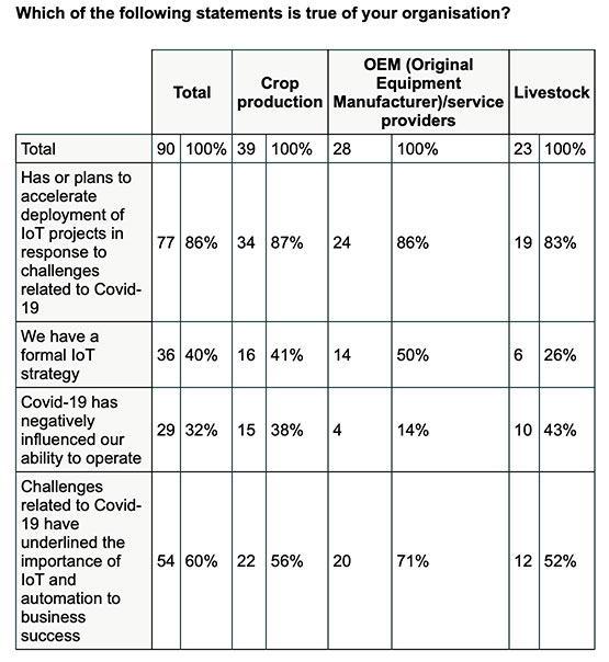
New Inmarsat research reveals a rapid increase in levels of industrial IoT maturity in 2021, with agricultural businesses accelerating IoT adoption in response to COVID-19
Research by Inmarsat, a global mobile satellite communications company, reveals a rapid increase in the maturity level of the industrial internet of things (IoT) across the agricultural sector since the start of the COVID-19 pandemic, with 86% of ag business accelerating or intending to accelerate deployment.
Respondents in the report, “Industrial IoT in the Time of COVID-19,” include crop producers, OEMs, service providers and livestock businesses, who report that COVID-19 demonstrated the importance of IoT to their businesses.
According to the research, adoption has seen huge progress from 2020 to 2021, with automation and cost savings the greatest drivers. Four-fifths (80%) of agricultural respondents have now fully deployed at least one IoT project, with 53% having achieved this in the 12-month period from the second quarter of 2020. Of the remaining 20% of agricultural respondents that have not yet adopted IoT in any form, all of them are either currently trialing it, or plan to deploy or trial at least one IoT project in the next two years.
Chart: Inmarsat
A further 86% of agricultural respondents indicated they have or they intend to accelerate the adoption of IoT in response to challenges related to COVID-19. This figure includes 46% who have already accelerated IoT adoption to respond to COVID-19, versus 29% who will accelerate over the next 12 months and 11% who will accelerate beyond the next 12 months.
The 46% that have already accelerated IoT adoption are less likely to state that COVID-19 has negatively impacted their ability to operate, demonstrating a link between IoT and business continuity during the pandemic. Additionally, more than half (60%) of respondents in the sector indicated that business and operational challenges related to COVID-19 have underlined the importance of IoT.
“We have seen agricultural producers take on more and more solutions that allow them to operate remotely, from autonomous irrigation control to the latest precision farming technologies, demonstrating increased faith in the technology,” said Steven Tompkins, Director of Market Development at Inmarsat.
As part of the research, Inmarsat is offering businesses the opportunity to measure their IoT readiness compared to the respondents in the survey, using their free IoT maturity tool.