Tag: IoT

  • Galileo signal updated for internet-of-things use

    Galileo signal updated for internet-of-things use

    News from the European Space Agency

    In April, Galileo marked a step forward with the deployment of a new signal component, known as E5a Quasi Pilot, on 12 satellites of Europe’s satellite navigation constellation. This upgrade makes Galileo signals easier to access, particularly on emerging mass-market, low-power devices used for Internet of Things and smart city applications.

    With the world’s most precise satellite navigation system, a constellation of more than 30 satellites and five billion of users worldwide, Europe’s Galileo continues to strengthen its position at the forefront of global navigation satellite systems (GNSS).

    Galileo signals, like other GNSS signals, traditionally consists of two components: pilot signals and data signals. The first ones are data-less and help enable the receiver to acquire and track the signal, while the second carry all the navigation information needed to pinpoint the target’s location.

    But what if this traditional concept could be rethought to respond to emerging market needs, particularly for users seeking faster and simpler acquisition?

    Galileo satellite in orbit
    Galileo satellite in orbit

    The European Space Agency and its industrial partners have developed a solution targeted at mass-market applications that require low power: E5a-QP, a Quasi-Pilot (QP) signal component transmitted in Galileo’s E5 band.

    The signal component is broadcast free of charge and now available for implementation in both new and upgraded chipsets, enabling all users of the Galileo Open Service to benefit from its capabilities.

    A small addition for a big computational deduction

    Reconfigured E5 spectrum
    Reconfigured E5 spectrum

    Quasi-Pilot means a pilot signal that retains its intended role but also carries a small amount of data, including the time information necessary for a first fix. This time information is fully predictable at user level. A Quasi-Pilot signal component is also characterised by a tailored signal structure that simplifies the acquisition process, which reduces the power consumption on the receiver’s end.

    This proves particularly useful for low-power, basic receivers such as those found in smartphones, smart-city infrastructure, internet-of-things devices and those that only need to receive a GNSS signal for a very small time to determine their position (also known as ‘snapshot’ devices).

    The deployment of E5a-QP also represents a key enabler for low-power receivers designed to process signals exclusively in the E5 band, rather than relying on signals in the E1 band. In this way, the resilience of the receiver against spoofing and jamming attacks is increased, as the fundamental acquisition process is no longer only dependent solely on E1 signals.

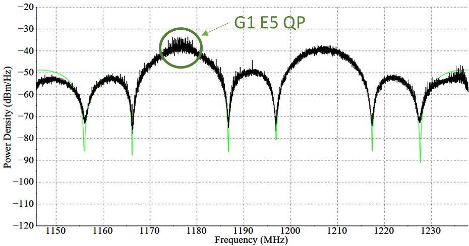
    Test campaigns have demonstrated that E5a-QP can reduce signal acquisition time by a factor of three, while substantially lowering the number of operations required for acquisition by a factor of eight.

    Testing, validation and in‑orbit deployment

    ESA and Industry Engineers in the ESTEC Navigation Payload Laboratory
    ESA and Industry Engineers in the ESTEC Navigation Payload Laboratory

    The introduction of this new Galileo signal component follows an extensive series of design, testing and validation that demonstrated the value of the signal and the feasibility of implementing new signal components on current Galileo satellites.

    Starting 2020, a design phase explored how to reconfigure the Galileo satellites’ payload to integrate the new signal component. Following on, a series of tests were run on engineering models at ESA’s Navigation Payload Laboratory to demonstrate the feasibility and performance benefits that can be achieved with the new signal component.

    A space antenna farm amid the Ardennes forest
    A space antenna farm amid the Ardennes forest

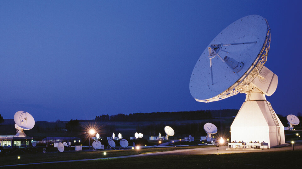
    In 2023, the solution was then validated using an in-orbit test bench: a duo of Galileo satellites operating in an elliptical orbit reconfigured to transmit the new signal component. The signal was measured at Galileo In-Orbit Test facility at ESEC in Belgium and DLR’s Signal Monitoring Facility in Germany, and successfully acquired and tracked by a set of receivers at ESTEC in the Netherlands. 

    First generation updated, second generation in mind

    Between November 2025 and April 2026, twelve Galileo satellites were updated to accommodate this new signal component, marking the completion of this deployment.

    This critical mass of satellites ensures that at least one of the satellites used to compute a position fix transmit the Quasi-Pilot signal at medium to high elevation angles, making sure that users around the world can benefit from the performance gains.

    This is just the beginning of Quasi-Pilot use within Galileo. All Galileo Second Generation satellites will broadcast additional and improved Quasi-Pilot signals on several frequencies, further enhancing their features and availability.

  • Telit Cinterion bundles Swift’s Skylark into integrated IoT positioning

    Telit Cinterion bundles Swift’s Skylark into integrated IoT positioning

    Telit Cinterion and Swift Navigation have announced an expanded partnership. Telit Cinterion will offer Swift Navigation’s Skylark Precise Positioning Service as part of an integrated IoT positioning solution.

    This service is available with Telit Cinterion’s dual-frequency GNSS modules and NExT cellular connectivity. IoT customers gain one source for the hardware, connectivity and Skylark Dx correction data needed for sub-meter positioning.

    What began in 2024 as a technical partnership has grown into a comprehensive joint offering, uniting hardware, connectivity, and corrections into a seamless solution for IoT customers.

    Telit Cinterion customers can now buy modules, connectivity and corrections under one contract. For many IoT projects, this cuts vendor coordination and avoids the cost and operational complexity of building or subscribing to an RTK base-station network.

    Skylark is available in three variants — Skylark Dx, Cx, and Nx RTK — to meet a broad range of requirements for accuracy, coverage, bandwidth, and power consumption.

    All Telit Cinterion dual-frequency L1 + L5 GNSS modules offer native support for Skylark Dx, which streams differential GNSS (DGNSS) corrections directly to the receiver over the cellular network. Skylark Dx runs over standard RTCM via Internet Protocol (NTRIP), using minimal bandwidth and power, and provides country-wide coverage. This makes it practical for IoT devices with limited bandwidth or tight power budgets.

    Typical applications include:

    • e-mobility
    • fleet and asset tracking
    • robotics
    • drones

    These are cases that don’t require centimeter-level RTK accuracy but do need reliable sub-meter positioning. Customers requiring higher accuracy can upgrade to Skylark Nx RTK on compatible module variants without redesigning their devices or changing suppliers.

    “Customers tell us they want precise positioning without complexity,” said Neset Yalcinkaya, president of IoT hardware at Telit Cinterion. “We’re bundling Skylark Dx with the GNSS modules and cellular connectivity we already ship. This gives customers one supplier and a single integration approach, plus a clear path to RTK down the road.”

    “At Swift Navigation, our mission is to make precise positioning a standard capability,” said Holger Ippach, chief operating officer at Swift Navigation. “This partnership advances that vision by embedding Skylark into Telit Cinterion’s GNSS modules and connectivity, giving customers direct access to reliable, sub-meter positioning without the integration overhead traditionally required.”    

    Service Availability

    Skylark Dx is available now with Telit Cinterion solutions in Europe, North America, Japan, South Korea and Taiwan. Coverage will expand as Swift Navigation adds regions.

    For more information, visit these links:

  • Hybrid RTK: A scalable path to high‑precision positioning for the IoT era

    Hybrid RTK: A scalable path to high‑precision positioning for the IoT era

    The world is rapidly filling with connected devices. IoT Analytics reports that 18.5 billion IoT devices were online in 2024, with growth accelerating toward an expected 21.1 billion by the end of 2025 and 39 billion by 2030. As artificial intelligence drives demand for richer, more precise device data, the need for reliable, high‑accuracy positioning becomes foundational.

    Yet today’s GNSS infrastructure — including cellular-based real‑time kinematic (RTK) networks — was never designed for this scale. Billions of devices — from vehicles to drones to industrial sensors — depend on location data, but the traditional GPS model struggles under three converging pressures: (1) massive device growth, (2) rising accuracy requirements, and (3) increasing vulnerability to interference.

    These pressures are reshaping expectations for positioning, navigation and timing (PNT) and creating demand for a new, more resilient delivery model.

    Why Accuracy and Resilience Matter More Than Ever

    Autonomous systems are the clearest example of the accuracy challenge. Xona Space Systems CTO Dr. Tyler Reid notes that safe autonomous driving requires 10 cm accuracy 95% of the time and 30 cm accuracy at “eleven nines” reliability. Standard GPS, accurate only to several meters, cannot meet these thresholds — even with traditional enhancement techniques.

    At the same time, GNSS signals face growing threats. Spoofing and jamming events are now daily occurrences in parts of Europe, and U.S. federal agencies increasingly require contract bidders to incorporate resilient PNT technologies alongside legacy GNSS.

    Finally, the explosion of IoT devices introduces a network‑scale challenge. Many of these devices could benefit from high‑precision positioning, but continuous unicast RTK streams are not an efficient use of cellular networks, especially as billions of devices come online.

    Together, these factors point to a simple conclusion:

    A new delivery model for high‑precision GNSS corrections is needed — one that is accurate, resilient, and scalable.

    Why a Hybrid Approach Is Required

    RTK positioning is the gold standard for centimeter‑level accuracy. It works by combining GNSS signals with correction data from a known base station. However, traditional RTK has two major limitations:

    1. Coverage constraints — corrections must be delivered within a limited range of the base station due to the fact that accuracy diminishes the further the GNSS base is from the rover.
    2. Network constraints — corrections are typically delivered over cellular networks, which become inefficient at scale.

    Precise Point Positioning (PPP‑RTK) can extend range and reduce dependency on local base stations, but today’s PPP‑RTK implementations are proprietary and lack a common standard.

    To support billions of devices — many mobile, many mission‑critical — the industry needs a correction‑delivery model that is:

    • Nationwide
    • Efficient at scale
    • Resilient to interference
    • Cost‑effective for high‑volume IoT deployments

    This is where hybrid RTK becomes essential.

    Introducing Hybrid RTK: A Dual‑Path Delivery Model

    Hybrid RTK refers to the dual‑path delivery of GNSS correction data, consisting of:

    • Primary path: ATSC 3.0 broadcast
    • Fallback path: Cellular (LTE/5G)
    • Upstream messaging: Cellular for acknowledgments or device telemetry

    Compared to a satellite-based RTK solution or even a cellular-only RTK solution, hybrid RTK will deliver corrections over a far more reliable and scalable network, because it’s both broadcast and terrestrial-based.

    Why broadcast first?

    ATSC 3.0 provides:

    • One‑to‑many multicast efficiency
    • Predictable capacity and uniform latency
    • Wide coverage footprints
    • Strong penetration in dense urban environments
    • Lower cost per delivered bit

    This makes it ideal for distributing high‑precision correction data to large numbers of devices simultaneously — something cellular networks are not optimized for.

    Why cellular second?

    Cellular fills in:

    • Coverage gaps where ATSC 3.0 is not yet deployed
    • Uplink needs (e.g., device status, position feedback)
    • Mobility scenarios requiring two‑way communication

    The result is a resilient, nationwide correction layer that scales with IoT growth.

    EdgeBeam Wireless: A New Entrant with a Broadcast‑First Architecture

    EdgeBeam Wireless is deploying a hybrid RTK network that leverages the existing infrastructure of U.S. television broadcasters — including secure facilities, hardened towers, and nationwide engineering resources — for both over-the-air RTK delivery and collocating GNSS base stations.

    This approach provides several advantages:

    • Accelerated deployment of GNSS base stations designed to complement existing base networks.
    • Lower infrastructure costs than cellular‑only RTK networks.
    • High reliability through broadcast delivery.
    • Scalable distribution for dense IoT environments.
    • Nationwide reach as ATSC 3.0 coverage expands.

    EdgeBeam’s broadcast‑first model — branded by the company as  “Enhanced GPS” or  “eGPS” — is best understood simply as hybrid RTK with broadcast as the primary downlink. While this hybrid approach does require some additional hardware to receive the broadcast, pricing is already very competitive to cellular because these chips will be found in every television set in the country. Moreover, EdgeBeam already has products available for end users that want to leverage a hybrid network without having to do any development work.

    Broadcast RTK: A New Network Layer at the Edge

    Broadcast RTK uses ATSC 3.0 to distribute GNSS correction data over the last mile. This creates a new edge network layer that can support both GNSS and other data applications, including:

    • High‑precision GNSS corrections
    • Multicast distribution of positioning data
    • Offloading of appropriate high‑volume traffic (e.g., video) from cellular networks
    • Enterprise‑grade reliability for industrial and transportation systems

    By shifting the heavy downlink load to broadcast, cellular networks are freed to handle uplink messaging and mobility support — a more efficient division of labor.

    This hybrid architecture is not just about improving individual device accuracy. It enables something more powerful.

    A New Generation of Shared Situational Truth

    When many devices operate on the same centimeter‑accurate reference frame at the same time, a new capability emerges: Shared Situational Truth (also known as shared situational awareness).

    This refers to a consistent, real‑time understanding of location and timing across a fleet, system, or environment. Hybrid RTK enables this by delivering synchronized, high‑precision PNT to large numbers of devices simultaneously. By offloading RTK delivery to a broadcast network, cellular and other communication networks can then be used to share a device’s position and other data with other local devices.

    What is being shared?

    • Precise location
    • Precise timing

    Who is sharing it?

    • Vehicles
    • Fleets
    • Drones
    • Industrial robots
    • Infrastructure sensors
    • Emergency services
    • Insurance and logistics platforms

    What does it enable?

    Examples include:

    • Safer ADAS/ADS through lane‑level awareness
    • Collision avoidance for drones and autonomous systems
    • Fleet optimization using precise, time‑aligned movement history
    • Improved insurance models through reliable behavior measurement
    • Faster accident resolution with time-synchronized location records
    • Infrastructure‑to‑vehicle coordination for road hazards or construction zones

    In transportation alone, EdgeBeam’s hybrid RTK solution could make entire traffic systems safer and more predictable — not just individual vehicles.  And importantly, this can be done far more efficiently than via just a cellular-based solution.

    Conclusion: A Foundational Shift in PNT Delivery

    The convergence of IoT growth, accuracy demands, and GNSS vulnerabilities is forcing a rethinking of how high‑precision positioning is delivered. Hybrid RTK — with broadcast as the primary downlink and cellular as a complementary path — offers a scalable, resilient, and cost‑effective solution.

    For industries ranging from automotive to logistics to public safety, the shift from “nice‑to‑have” to “must‑have” high‑precision PNT is already underway. As hybrid RTK networks expand, the ability to deliver centimeter‑level accuracy at scale will unlock new applications, new efficiencies, and new expectations for how devices understand and interact with the world.

    EdgeBeam Wireless is building this new correction layer — one designed for the billions of devices that will depend on precise, reliable positioning in the years ahead.

  • New u-blox F11 platform provides ultra-low power GNSS for all environments

    New u-blox F11 platform provides ultra-low power GNSS for all environments

    The new u-blox F11 platform provides L1/L5 dual-band standard-precision GNSS designed to significantly improve positioning accuracy while dramatically reducing power consumption to as low as 7 mW in typical configurations using low-energy accurate positioning (LEAP) mode for tracking and wearable applications.

    The F11 platform marks a major step forward in meter-level GNSS positioning, the company said. It combines ultra-low power operation with intelligent signal management to meet the evolving demands of tracking, wearables, telematics and mobility applications — including micromobility solutions and drones. The platform enables device manufacturers to achieve longer battery life, faster and more reliable position fixes, and greater design flexibility, u-blox said.

    Intelligent dual-band operation

    Expanding power saving capabilities, the F11 platform is a new situationally aware GNSS architecture (with integrated geofencing and indoor detections) that dynamically balances accuracy and power consumption. By selectively using dual-band L1/L5 operation only when it helps maintain the positioning performance, the F11 platform reduces energy use while providing resilience and maintaining confidence in location data.

    Compared to previous generations, the platform delivers up to 40% lower power consumption during signal acquisition and up to 30% lower power consumption in continuous tracking modes, while improving position accuracy by up to 30% in challenging environments such as dense urban areas. For long-life tracking applications (assets, livestock, pets and people), optimized first-fix performance further reduces GNSS on-time, enabling multi-year battery operation.

    For scalable, high-volume applications

    The u-blox F11 platform addresses the growing demand for GNSS solutions that are robust, power-efficient, and easy to integrate across a wide range of industries. The platform supports both single-band and dual-band operation within a single footprint, allowing device manufacturers to simplify designs and scale products across multiple market segments.

    Key application areas include:

    • asset and fleet tracking
    • consumer and fitness wearables
    • aftermarket telematics
    • livestock tracking
    • people/pet tracking
    • industrial sensing and IoT
    • micromobility and mobility services
    • consumer drones and action cameras

    By focusing on real-world performance rather than raw specifications, the F11 platform enables faster development cycles, improved user experience, and lower total system cost for OEMs — with form-factor compatibility and firmware upgradeability as a way to future proof designs.  

    Availability

    The platform is being showcased at Embedded World 2026. First products will be available by the end of June 2026. 

  • Iridium launches next-generation IoT platform

    Iridium launches next-generation IoT platform

    Iridium Communications, a provider of global voice, data, and positioning, navigation and timing (PNT) satellite services, has unveiled the Iridium 9604, a compact, three-in-one IoT module that integrates Iridium short burst data (SBD) satellite service, LTE-M cellular connectivity, and GNSS positioning into a single platform.

    By combining these features in one device, the Iridium 9604 reduces solution complexity, lowers costs, and accelerates time to market, making dual-mode IoT connectivity viable for price-sensitive, high-volume deployments.

    The Iridium 9604 beta program — launched earlier this year and oversubscribed by a select group of companies — has generated positive industry feedback highlighting:

    • Lower costs, simplified design, and enabling of location-aware network selection
    • Savings of 60 percent or more in board space with the 3-in-1 module, Iridium’s smallest ever form factor
    • Easy-to-use developer resources.

    “As an early Iridium 9604 developer, utilizing the three-in-one module has already fundamentally changed our product economics,” said Alastair MacLeod, CEO, Ground Control. “We eliminated two components from our bill of materials, reduced our board size, and simplified our power architecture.”

    MacLeod continued, “Additionally, having dual mode connectivity options enables a smarter, location-aware network selection in our application. The Iridium 9604 turned what would have been a complex multi-component design into a single-module solution. This is a major breakthrough for our IoT solutions.”

    “Our customers require essential data and real-time intelligence to operate with confidence anywhere in the world,” said Dean Welten, CEO, Everlink. “By integrating the Iridium 9604 with our secure cloud platform, we can now enable global connectivity, greater operational efficiency, and measurable impact at scale.”

    Representing the next phase of Iridium’s IoT strategy, the Iridium 9604 is moving the company beyond traditional satellite-only modules to a unified, multi-mode connectivity architecture. The Iridium network now offers customers three IoT service paths to follow:

    • Iridium SBD packaged with cellular and GNSS in the Iridium 9604 or SBD/Iridium Burst dedicated modules
    • Iridium NTN Direct for standards-based direct-to-device using third-party chips
    • Iridium Messaging Transport-based (IMT) for industrial-scale, larger payload capabilities with the Iridium Certus 9704

    The Iridium 9604, built on the u-blox SARA-R5 platform, delivers a compact 16 mm x 26 mm x 2.4 mm form factor, best for dual-mode IoT deployments previously cost-prohibitive across industrial, infrastructure, and mobility applications.

    Commercial availability begins in June 2026 with the Iridium 9604 Development Kit made available for testing satellite and cellular services. Reserve priority access at www.iridium.com/9604.

  • Quectel unveils smart single board computers to accelerate device development

    Quectel unveils smart single board computers to accelerate device development

    Quectel Wireless Solutions, a global IoT solutions provider, launched three smart single board computers Tuesday designed to speed product development and reduce costs.

    The QSM368Z, QSM560DR and QSM668SR offer developers connectivity, operating system and memory options for various applications, the company said.

    “These boards are fully finished hardware that can be easily integrated inside customers’ larger systems across a wide range of IoT use cases,” said Raymond Wang, head of Smart SoC at Quectel Wireless Solutions. “Provided in a ready-to-use, single, low-cost platform, these boards are helping to simplify and accelerate the development process for IoT devices of all types, significantly reducing development time with rapid prototyping and cutting development costs.”

    The QSM368Z features the Rockchip RK3568 IoT processor with a quad-core ARM Cortex-A55 CPU, ARM Mali G52 GPU, 8M ISP HDR and 1 TOPS NPU. The board supports Linux and Android operating systems.

    The device includes triple-screen concurrent display support, 1,000 Mbps Ethernet and 4K video encoding. Built-in Wi-Fi 5 and Bluetooth 4.2 come standard, with optional support for Quectel LTE Cat 1, LTE Cat 4, Wi-Fi 6 and GNSS modules.

    The QSM368Z measures 120mm x 100mm x 22.25mm, weighs about 90 g and operates in temperatures from -10 C to +75 C. Applications include IoT gateways, smart displays, industrial terminals, safety monitoring systems, NAS, NVR/DVR and automotive NVR solutions.

    The QSM560DR features 12 TOPS NPU and supports Ubuntu, Android and Windows. The platform’s multi-mode 5G capability supports both NSA and SA networks, with 3G and 4G fallback. Wi-Fi 6E with DBS and 2×2 MU-MIMO technologies enable faster data transmission.

    The device supports downlink speeds up to 2.5 Gbps on 5G NSA. It measures 120.5mm x 106mm x 22.5mm, weighs approximately 120 g and operates from -35 C to +75 C. Target markets include smart manufacturing, retail analytics, robotics and connected infrastructure.

    The QSM668SR supports Android, Linux and Ubuntu and features 1.1 TOPS NPU. The board supports LTE Cat 4, Wi-Fi, Bluetooth and GNSS. Under LTE Cat 4, the board achieves uplink speeds up to 150 Mbps and downlink speeds up to 50 Mbps. Bluetooth 5.0 is included.

    Optional GNSS functionality provides positioning through GPS, GLONASS, BDS, Galileo, QZSS and SBAS satellite constellations.

    The device includes HDMI, camera inputs, Ethernet, UART, USB, I²C, RS232, RS485, CAN, SD and SIM interfaces. It measures 102mm x 100mm x 23mm, weighs approximately 97.7 grams and operates from -20 C to +75 C. Applications include IoT gateways, smart home systems, industrial control terminals, retail solutions, safety monitoring, vehicle equipment and logistics devices.

    Quectel also provides antennas for cellular, Wi-Fi, Bluetooth and GNSS networks, plus custom antenna design and optimization services.

  • FreeGNSSNetwork: Sateliot launches project with ESA to break GNSS dependency

    FreeGNSSNetwork: Sateliot launches project with ESA to break GNSS dependency

    Sateliot, a leading satellite telecommunications operator in 5G IoT connectivity, will test a pioneering system that allows its satellites to connect with IoT devices without relying on GNSS. The breakthrough opens new opportunities in sectors such as defense and security, where Europe’s technological autonomy and operation in GNSS-denied environments are strategic priorities.

    Low-Earth orbit (LEO) satellite constellations, such as the one developed by Sateliot, provide coverage in areas beyond the reach of terrestrial networks — over half of the planet’s surface. However, until now, they depended on GNSS, increasing both the energy consumption of devices and terminal costs.

    The FreeGNSSNetwork project, signed with the European Space Agency (ESA) and led jointly with GMV, eliminates this dependency using advanced algorithms that enable devices to calculate their position directly from the satellites’ signals. This maintains a stable and accurate connection even under complex conditions such as wartime scenarios.

    According to the company, this project represents a paradigm shift and lays the groundwork for developing 6G technology, in which Sateliot actively contributes within the 3GPP framework.

    The FreeGNSSNetwork enables device positioning with an accuracy of approximately 10 meters and provides extremely precise time synchronization services of 50 nanoseconds, the equivalent of 0.00000005 seconds.

    The system is being tested in laboratories that replicate real satellite communication conditions and will be demonstrated in orbit with prototype satellites and terminals, sending positioning, navigation, and timing (PNT) data directly to IoT devices.

  • Rx Networks launches GNSS correction service with centimeter-level accuracy

    Rx Networks launches GNSS correction service with centimeter-level accuracy

    Rx Networks has introduced TruePoint | FOCUS, a high-precision, cloud-based GNSS correction service that offers instantaneous centimeter-level accuracy for a variety of applications. This service is designed to address the needs of industries requiring real-time precision, such as micro-mobility, smart agriculture, robotics, UAVs, IoT and machine control.

    TruePoint | FOCUS supports both Real-Time Kinematic (RTK) and PPP-RTK modes to offer flexibility and high performance. The RTK mode is hardware-agnostic, ensuring compatibility with any RTK-enabled GNSS receiver. It uses standard correction protocols like RTCM v3 and supports access via NTRIP for seamless integration and rapid deployment. The PPP-RTK mode leverages State Space Representation (SSR) to deliver high-accuracy positioning with optimized bandwidth usage. This mode combines the benefits of global coverage from PPP with the fast convergence times of RTK, making it suitable for applications requiring seamless operation over large areas.

    The service is notable for its ability to process more GNSS signals than many competing solutions, enhancing its resilience and performance in challenging environments. It supports signals from GPS, Galileo and BeiDou constellations, offering comprehensive correction capabilities. According to the company, TruePoint | FOCUS guarantees consistent centimeter-level accuracy with a 99.9% service level agreement, ensuring reliability for users operating in regions such as North America, Europe and China.

    TruePoint | FOCUS is available for trial in both RTK and PPP-RTK modes across covered regions, with plans to expand its geographic reach. Interested users can request a complimentary 30-day trial license to evaluate the service.

  • SECO launches Qualcomm-based SOM-SMARC modules

    SECO launches Qualcomm-based SOM-SMARC modules

    SECO, a global provider of end-to-end technological solutions for the digitalization of industrial products and processes, has released its first Smart Mobility Architecture (SMARC) System on Modules (SoMs) based on Qualcomm QCS6490 and Qualcomm QCS5430 application processors. These new SMARC modules are the first results of SECO’s strategic collaboration with Qualcomm Technologies, announced in September 2023. Both companies aim to help accelerate the development of innovative edge computing products for the industrial internet-of-things (IoT) world.

    The SOM-SMARC-QCS6490 is designed to simplify the use of the Qualcomm QCS6490 processor. The chipset offers support for artificial intelligence (AI) and computing, robust performance at low power and expanded interfaces and peripherals catering to diverse industrial use cases.

    The Qualcomm Adreno 643 GPU offers enhanced graphics performance and energy efficiency. It supports FHD+ at 120 fps resolution on primary and secondary displays up to 4k Ultra HD at 60Hz. The SOM-SMARC-QCS6490 supports Microsoft Windows 11 IoT Enterprise, Yocto Linux, and Android, with both commercial (0°C to +60°C) and industrial (-30°C to +85°C) temperature variants available.

    The SOM-SMARC-QCS5430, powered by the Qualcomm QCS5430, is a mid-tier solution that slightly moderates CPU and GPU performance. This system-on-chip (SoC) combines enhanced connectivity, performance and edge AI-powered camera capabilities. It also provides scope for field software-based upgrades of the CPU and GPU by using the processor’s capabilities.

  • KP Performance Antennas releases line of IoT antennas

    KP Performance Antennas releases line of IoT antennas

    Photo:
    Image: KP Performance Antennas

    KP Performance Antennas, an Infinite Electronics brand and a manufacturer of wireless network antennas, has released internet of things (IoT) multiband combination antennas. The antennas are designed to enhance connectivity for vehicle fleets and base stations.

    The IoT multiband combination antennas have dedicated ports for cellular, Wi-Fi and GPS bands. They are also indoor and outdoor IP69K rated and can withstand harsh environmental conditions, such as extreme temperatures, water and dust.

    The antennas are suitable for transportation emergency response and agriculture applications.

    KP Performance Antennas’ IoT multiband combination antennas are in-stock and available now.

  • Taoglas invisible antennas available for IoT apps

    Taoglas invisible antennas available for IoT apps

    Taoglas has released three near-invisible antennas supporting cellular, Wi-Fi and GNSS technologies, the TFX62.A, TFX257.A and TFX125.A . With “peel and stick” mounting to any nonmetal surface, the TFX series antennas offer an alternative to standard opaque antennas.

    The TFX62.A, TFX257.A and TFX125.A come with an adhesive and have an enclosed carrier terminated with a FAKRA connector for easy installation. The series leverages a sub-millimeter thick hybrid transparent conductive film that offers designers an invisible antenna solution.

    The TFX series antennas are suitable for mobility, public infrastructure, medical devices, transportation and emerging IoT applications. Use cases for the antennas include electric vehicle chargers and parking meters, smart buildings and transportation vehicles.

    The TFX series antennas are available now.

    TFX125.A (Image: Taoglas)
    TFX125.A (Image: Taoglas)

    TFX257.A. (Image: Taoglas)
    TFX257.A. (Image: Taoglas)

    TFX62.A. (Image: Taoglas)
    TFX62.A. (Image: Taoglas)

  • STMicroelectronics releases ST87M01 for IoT devices

    STMicroelectronics releases ST87M01 for IoT devices

    Image: STMicroelectronics
    Image: STMicroelectronics 

    STMicroelectronics has released an ultra-compact, low-power, narrow-band internet of things (NB-IoT) industrial module with GNSS geo-location capabilities, the ST87M01. The fully programmable, certified LTE Cat NB2 NB-IoT industrial module covers worldwide cellular frequency bands and integrates advanced security features. 

    The ST87M01 is an integrated native GNSS receiver with multi-constellation access, which ensures enhanced and accurate localization. The module has a diminutive 10.6 mm x 12.8 mm land grid array footprint, making it suitable for applications where a small form factor is key.  

    The STM8701 offers flexibility for product developers, presenting a fully programmable IoT platform enabling users to embed their own code into the module for simple applications. A variety of protocol stacks are available to handle popular IoT use cases. 

    The ST87M01 targets wide-ranging IoT applications that require ultra-reliable low-power wide-area network connectivity and has ultra-low power consumption with less than 2 µA in low-power mode and transmit output power up to +23 dBm.  

    Suitable applications for the module include smart metering, smart grid, smart building, smart city and smart infrastructure applications, as well as industrial condition monitoring and factory automation, smart agriculture and environmental monitoring. The module can also be combined with a separate host microcontroller, permitting many more use cases.