Tag: ISRO

  • India’s NavIC constellation in jeopardy as majority of satellites become defunct

    India’s NavIC constellation in jeopardy as majority of satellites become defunct

    Disclaimer: A previous version of this article contained an error that has since been removed. We strive for accuracy and transparency, and the current version reflects updates correcting this mistake. Please refer to the information below for more current and accurate details on India’s NavIC satellite constellation.


    India’s regional satellite navigation system, NavIC (Navigation with Indian Constellation), is facing a severe operational crisis, with only four of its 11 satellites currently operational, according to government data and news reports.

    Developed and maintained by the Indian Space Research Organisation (ISRO), NavIC is intended to provide precise positioning, navigation and timing (PNT) services across India and up to 1,500 km beyond its borders. However, this constellation is now on the brink of becoming near-defunct, according to the Indian Defence Research Wing.

    Of the four satellites still fully operational, IRNSS-1B has already exceeded its planned 10-year mission life and is at risk of imminent failure. At the same time, IRNSS-1F is also nearing the end of its lifespan with partial equipment failures. IRNSS-1I, launched in 2018, is expected to remain functional until around 2028 but its longevity remains uncertain given the premature failures in the constellation.

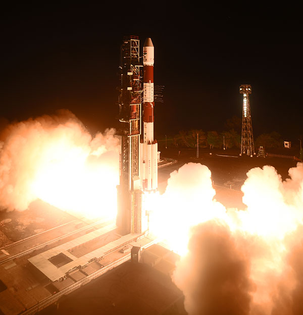
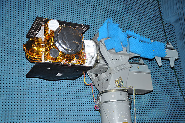
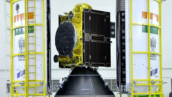
    The new generation satellite, NVS-01, launched in May 2023, is operational. Still, its immediate successor, NVS-02, launched in January 2025, failed to reach its intended geostationary orbit due to a propulsion system malfunction and remains stranded in a transfer orbit, rendering it unable to provide navigation services.

    The failure of NVS-02 to reach orbit halted progress and highlighted technical challenges that ISRO must address to avoid repeat failures. The Indian government has committed to launching the remaining NVS satellites (NVS-03, NVS-04 and NVS-05) by the end of 2026.

    This year, ISRO has had two mission failures within seven months: the NVS-02 satellite failed to reach orbit and the PSLV-C61 launch vehicle failure destroyed the EOS-09 Earth observation satellite.

    Timely replacement and system upgrades are crucial for maintaining India’s strategic autonomy and meeting the growing demands for accurate, independent navigation services in both civilian and defense applications.

  • Indian navigation satellite stranded in transfer orbit after valve malfunction

    Indian navigation satellite stranded in transfer orbit after valve malfunction

    The Indian Space Research Organisation (ISRO) has encountered a significant setback with its recently launched NVS-02 navigation satellite. Launched on Jan. 28, 2025, the satellite is currently stranded in a transfer orbit due to a critical failure in its onboard propulsion system, ISRO stated in a report. The issue occurred when the valves admitting the oxidizer to fire the thrusters for orbit raising failed to open, which prevented the satellite from reaching its intended orbital position.

    The NVS-02 satellite, part of India’s Navigation with Indian Constellation (NavIC) program, was launched using a Geosynchronous Satellite Launch Vehicle (GSLV) Mark II rocket from the Satish Dhawan Space Centre. The launch placed the satellite into a geostationary transfer orbit with a perigee of approximately 165 km and an apogee of approximately 37,582 km.

    ISRO noted in its statement that other systems on the spacecraft were working well, including a successful deployment of its solar panels.

    “The satellite systems are healthy and the satellite is currently in elliptical orbit. Alternate mission strategies for utilizing the satellite for navigation in an elliptical orbit are being worked out,” ISRO stated.

    The space agency is now exploring alternative mission strategies to utilize the satellite for navigation in its current elliptical orbit. However, the low perigee of NVS-02 poses a significant risk, as it exposes the spacecraft to high atmospheric drag, potentially leading to an early reentry if the orbit cannot be raised.

    NVS-02 is based on ISRO’s I-2K satellite bus, which has been used for other Indian communications and navigation satellites operating in geostationary orbit. The spacecraft had a launch mass of 2,250 kg.

    The spacecraft was intended to operate at 111.75 degrees east in GEO, replacing the IRNSS-1E spacecraft there. It is the second of five satellites planned for India’s Navigation with Indian Constellation, or NavIC, program to provide positioning, navigation and timing services in India and the surrounding region. The first, NVS-01, launched in 2023 and operates in GEO.

  • ISRO offers free online course on GNSS

    ISRO offers free online course on GNSS

    Logo: Indian Space Research OrganisationA free 12-day online course on GNSS will be offered by the Indian Institute of Remote Sensing (IIRS), part of the Indian Space Research Organization (ISRO).

    “Overview of Global Navigation Satellite System” (Course-ID: 107) will be held Sept. 19-30. The course is designed to help with the urgent demand for trained manpower in remote sensing, geographic information systems (GIS), GNSS and associated geospatial technologies. The course will introduce GPS and GNSS, receivers, processing methods, errors and accuracy.

    The course will cover the following topics:

    • GPS receivers, processing methods, errors and accuracy
    • satellite-based augmentation systems and GPS-aided and GEO-augmented navigation (GAGAN)
    • GPS signal characteristics and data formats (broadcast and precise ephemeris)
    • Indian Regional Navigation Satellite System (IRNSS)
    • DGPS demonstration
    • advanced GNSS processing
    • development of satellite navigation technology, TRANSIT, TSKLON, GNSS (GPS, GLONASS, Galileo and BeiDou), principles of GNSS, segments and applications
    • satellite navigation.

    The course is open to undergraduate and postgraduate students; technical or scientific staff of central or state government; and faculty or researchers at university or institutions.

    Course study materials — lecture slides, recorded video lectures, open-source software and handouts of demonstrations — will be made available through the IIRS learning management system E-CLASS.

    Visit the IRSS website for details.

  • ISRO partners with OPPO on NavIC messaging app

    ISRO partners with OPPO on NavIC messaging app

    logoThe Indian Space Research Organization (ISRO) and India’s Department of Space have signed a memorandum of understanding (MOU) with OPPO India to strengthen the research and development of the NavIC messaging service to provide a convenient and user-friendly platform.

    The MoU will pave the way for future collaborations between ISRO and OPPO India to develop indigenous solutions by incorporating the NavIC short-messaging feature into smartphones released by OPPO India.

    The MoU will enable ISRO and OPPO India to exchange technical information on the NavIC messaging services. This will enable the building of rapid, ready-to-use, end-to-end application-specific solutions that integrate the NavIC messaging service with OPPO’s mobile handset platform, with Indian end-users in mind.

    The MOU also aims to help fulfill “Atmanirbhar Bharat,” which translates to “self-reliant India.” Atmanirbhar Bharat is a phrase used and popularized by Indian Prime Minister Narendra Modi and the Government of India in relation to the country’s economic development and vision.

  • ISRO offers free online GNSS course for students, pros

    ISRO offers free online GNSS course for students, pros

    Logo: Indian Space Research OrganisationThe Indian Space Research Organisation (ISRO) is conducting a free online course on GNSS for students and professionals Sept. 13-24.

    The course is the 87th outreach program conducted by the Indian Institute of Remote Sensing (IIRS), an ISRO division.

    The GNSS course provides an introduction to GPS and GNSS, receivers, processing methods, errors and accuracy.

    Courses are also available on geographic information systems and remote sensing.

    Learn more at the website.


  • India seeks global adoption of its NavIC system

    India seeks global adoption of its NavIC system

    Logo: Indian Space Research OrganisationA new draft policy in India seeks to foster global use of its Indian NavIC satellite navigation system. The draft Indian Satellite Navigation Policy 2021 (SATNAV Policy 2021) is part of reforms of the Indian Space Research Organisation (ISRO)/Department of Space (DoS).

    “ISRO/DOS shall work towards expanding the coverage from regional to global to ensure availability of [the] NavIC standalone signal in any part of the world without relying on other GNSS and aid in wide utilization of [the] Indian navigation system across the globe,” states the policy document.

    DoS will push NavIC for global use to meet demand for positioning, navigation and timing in commercial, strategic and societal applications. It aims to ensure the continuous availability of free-to-air navigation signals for civilian uses, while providing secured navigation signals for strategic uses.

    The draft document plans for continuity of NavIC and GAGAN services, while also ensuring Indian satellite navigation and augmentation signals are compatible and interoperable with other GNSS/SBAS signals. The International Telecommunication Union (ITU) regulated frequency allocation to prevent interference among signals from different systems. This interoperability allows users to seamlessly switch from one constellation system to another and results in improved navigation signal, especially in a situation where an area is obscured from one satellite system.

    DoS will continue to work with ITU for frequency allocation. It will also take part in the United Nations Committee on Peaceful Uses of Outer Space (UNCOPUOS), International Civil Aviation Organisation (ICAO) and International Maritime Organisation (IMO).

    In addition, ISRO will provide technical support for academic institutions in GNSS research and applications.

  • 3GPP approves NaVIC for global commercial use

    3GPP approves NaVIC for global commercial use

    Disy Informationssysteme GmbH, www.gis2go.com
    Photo: Gis2Go

    Global mobile wireless standards body 3GPP has given its approval to the regional navigation system created by the Indian Space Research Organization (ISRO), known as NaVIC, reports The Times of India.

    The approval was given for the system’s use in Rel-16 LTE and Rel-17 5G NR specifications, paving the way for wider commercial adoption of NaVIC and allowing it to be integrated with 4G, 5G and internet of things technology (IoT).

    Once these specifications are adopted by Telecommunications Standards Development Society, India (TSDSI), IoT devices in India can make a switch from GPS to NaVIC.

    Electronics companies can start designing and building integrated circuits and mass manufacture other products created to be compatible with NaVIC.

  • Seen & Heard: Robot pizza delivery, NavIC rising

    Seen & Heard: Robot pizza delivery, NavIC rising

    “Seen & Heard” is a monthly feature of GPS World magazine, traveling the world to capture interesting and unusual news stories involving the GNSS/PNT industry.

    Photo: Nuro
    Photo: Nuro

    Hey, R2, Where’s my pizza?

    Domino’s pizza will start using Nuro’s R2 unmanned vehicles for delivery in Houston, Texas, later this year. Once customers have opted in, they can track the R2 vehicle via the Domino’s app and will be provided with a unique PIN code to unlock a compartment to get their pizza. Nuro is already at work in Houston delivering goods from dinner to dry cleaning.

    Screenshot: BBC
    Screenshot: BBC

    Drone Attack

    A BBC documentary has sent the drone industry into a tizzy. “Britain’s Next Air Disaster? Drones” begins with the December 2018 Gatwick Airport incident when two drones entering airport airspace led to a disruption of operations for three days. Dronemakers dislike the documentary’s thrust that drones are a threat to public safety and a tool for terrorists, while barely mentioning their positive contributions in fields such as search and rescue, plant inspections and agriculture.

    Photo: Rawpixel.com/Shutterstock.com
    Photo: Rawpixel.com/Shutterstock.com

    NavIC Rising

    The Indian Space Research Organisation is in talks with chipmakers Qualcomm and Broadcom to substitute GPS in Indian mobile phones with its own satellite system (NavIC). The Times of India noted that cellphones hold the biggest commercial potential for NavIC, with more than 650 million mobile users in India. ISRO and the Indian Air Force are also working to equip fighter jets with the navigation system, and commercial vehicles registered after April 1 are mandated to have NavIC trackers.

    Photo: Monitum Pty Ltd.
    Photo: Monitum Pty Ltd.

    Infrastructure sensors are Mthing

    Internet of things (IoT) project Mthing is researching GNSS monitoring sensors to record near-real-time measurements of infrastructure construction. The 18-month project in Brisbane, Australia, aims to develop GNSS IoT sensors that will provide cost-efficient, constant and high-precision monitoring that will connect to cloud services and provide instant alerts. Mthing aims to produce low-cost sensors with broad market potential. The research team includes Queensland University of Technology, survey company Monitum, and the Innovative Manufacturing Cooperative Research Centre.

  • India to host GLONASS ground station for Russia

    India to host GLONASS ground station for Russia

    ISRO Logo

    The Indian Space Research Organisation is getting ready to host a ground station for Russia’s GLONASS. The ground station will help the Russian navigation system become more efficient, reports the Times of India.

    The ground station will be built in Bengaluru, a city that is already home to the ISRO Telemetry, Tracking and Command Network (Istrac). Istrac will host the Russian ground station as well.

    A memorandum of understanding was signed between the two nations in October 2016. In return, Roscosmos will host ground-measurement gathering stations in Russia for India’s NavIC, which will boost the operations of the IRNSS satellites.

  • India successfully launches IRNSS-1I navigation satellite

    India successfully launches IRNSS-1I navigation satellite

    A replacement satellite for NavIC, India’s navigation constellation, was successfully launched April 11 from Satish Dhawan Space Centre SHAR, Sriharikota.

    In its 43rd flight, the India Space Research Organization’s (ISRO’s) Polar Satellite Launch Vehicle PSLV-C41 propelled the 1,425-kilogram IRNSS-1I Navigation Satellite into orbit.

    All three rubidium atomic clocks on IRNSS-1A have failed. A replacement satellite, IRNSS-1H, was launched on Aug. 31, 2017, but was not successfully deployed. This satellite, IRNSS-1I, is also a replacement satellite for IRNSS-1A.

    PSLV-C41 lifted off at 0404 hrs (4:04 a.m.) IST, as planned, from the spaceport’s First Launch Pad. After a flight lasting about 19 minutes, the vehicle achieved a sub-geosynchronous transfer orbit with a perigee (nearest point to Earth) of 281.5 km and an apogee of 20,730 km inclined at an angle of 19.2 degrees to the equator, following which IRNSS-1I separated from PSLV.

    After separation, the solar panels of IRNSS-1I were deployed automatically. ISRO’s Master Control Facility (MCF) at Hassan, Karnataka, took over the control of the satellite. In the coming days, orbit maneuvers will be performed from MCF to position the satellite at 55 degrees East longitude in the planned geosynchronous orbit with an inclination of 29 degrees to the equator.

    IRNSS-1I is the latest member of the Navigation with Indian Constellation (NavIC) system. NavIC, also known as Indian Regional Navigation Satellite System (IRNSS), is an independent regional navigation satellite system designed to provide position information in the Indian region and 1500 kilometers around the Indian mainland.

    A number of ground facilities responsible for IRNSS satellite ranging and monitoring, generation and transmission of navigation parameters, satellite control and network timing have been established in many locations across the country as part of NavIC.

  • India preps for navigation satellite launch

    India preps for navigation satellite launch

    Another navigation satellite is scheduled to join India’s NavIC constellation this week. IRNSS-1I is on the launchpad, with launch set for Thursday, April 12, at 04:04 (IST), according to the India Space Research Organization (ISRO).

    The 32-hour countdown activity began at 20:04 IST on Tuesday. Follow the launch here.

    All three rubidium atomic clocks on IRNSS-1A have failed. A replacement satellite, IRNSS-1H, was launched on Aug. 31, 2017, but was not successfully deployed. This satellite, IRNSS-1I, is also a replacement satellite for IRNSS-1A.

    Satellite IRNSS-1I will be the eighth satellite to join the NavIC constellation (formerly IRNSS). The satellite will be launched from First Launch Pad (FLP) of SDSC SHAR, Sriharikota, using India’s Polar Satellite Launch Vehicle (PSLV), in its 43rd flight (PSLV-C41) in XL configuration. The XL configuration is being used for the 20th time.

    IRNSS-1I undergoes testing at the Compact Antenna Test Facility. (Photo: ISRO)

    IRNSS-1I’s predecessors — IRNSS-1A, 1B, 1C, 1D, 1E, 1F and 1G — were launched by PSLV-C22, PSLV-C24, PSLV-C26, PSLV-C27, PSLV-C31, PSLV-C32 and PSLV-C33 in July 2013, April 2014, October 2014, March 2015, January 2016, March 2016 and April 2016 respectively. See the GPS World Almanac for details on the constellation.

    Like all other IRNSS satellites, IRNSS-1I also has a lift-off mass of 1425 kilograms. The configuration of IRNSS-1I is similar to IRNSS-1A, 1B, 1C, 1D, 1E, 1F and 1G.

    Like its IRNSS predecessors, IRNSS-1I also carries two types of payloads — navigation and ranging. The navigation payload of IRNSS-1I transmits signals for the determination of position, velocity and time. This payload is operating in L5-band and S-band. Rubidium atomic clocks are part of the navigation payload of the satellite.

    The ranging payload of IRNSS-1I consists of a C-band transponder, which facilitates accurate determination of the range of the satellite. It also carries Corner Cube Retro Reflectors for LASER Ranging.

  • IRNSS-1H navigation satellite launch unsuccessful

    The Aug. 31 launch of a new Indian Regional Navigation Satellite System (IRNSS) satellite failed when the protective fairing did not separate.

    Indian Space Research Organisation (ISRO) chairman AS Kiran Kumar confirmed that the mission to launch India’s eighth navigation satellite, IRNSS-1H, from the second launch pad at the spaceport of Satish Dhawan Space Centre, Sriharikota, was unsuccessful.

    The 1425-kg satellite was expected to expand the existing seven satellites of the NavIC constellation. The launch vehicle PSLV-C39 lifted the satellite on Aug. 31 using the XL variant, of PSLV equipped with six strap-ons, each carrying 12 tons of propellant.

    The three phases of the launch went smoothly, but unfortunately, the heat shield which was supposed to be separated in the fourth stage could not be detached.

    IRNSS-1H was planned as a replacement satellite for IRNSS-1A.