Tag: ISRO

  • System of Systems: Second QZSS Signal on Air

    System of Systems: Second QZSS Signal on Air

    QZS-2 L-band spectra, July 18, 2017, Weilheim, Germany. (Courtesy DLR)

    Second QZSS Signal on Air

    The successful launch of the Michibiki No. 2 satellite of the Quasi-Zenith Satellite System (QZSS) on June 1 has been followed by broadcast initiation. Researchers at the German Aerospace Center, Deutsches Zentrum für Luft- und Raumfahrt (DLR), have been observing the satellite from their ground station in Weilheim. They will provide a written analysis in the September issue.

    The Japan Aerospace Exploration Agency launched first Michibiki satellite of the anticipated four-satellite constellation in September 2010.

    Air Force to Recompete GPS III Follow-on

    The U.S. Air Force will launch multibillion-dollar competition between current GPS III contractor Lockheed Martin Corp. and former GPS Block I and Block II contractor Boeing Co. for as many as 22 new GPS III satellites. At press time, an industry day in was scheduled for July 20 in El Segundo, California, to solicit company input, according to a new draft Request For Proposals.

    In 2015 the Air Force undertook the first phase of a now two-year process to determine whether to put the next block of satellites up for competition. An initial review “has determined that viable, low-risk, high-confidence sources exist to conduct a full and open competition” for a second phase starting in fiscal 2018, according to the draft.

    Lockheed Martin is assembling the first 10 satellites of the Block III program. Formal delivery of the first satellite was scheduled earlier this year, delayed by of a series of now-resolved problems with the navigation payload, cracked capacitors and a subcontractor gaffe last year that resulted in the wrong part being tested.

    The satellite, which passed all of its qualification testing and verification, has been placed in storage pending the results of an unrelated review of the propulsion systems used to boost military satellites into orbit. The plan remains to launch the first GPS III satellite by spring of 2018.

    “Lockheed Martin is working closely with the Air Force on resolving any concerns about the mission readiness of SV01’s Propulsion Subsystem,” Eschenfelder said in February. “We are confident that this review will not delay the Air Force’s planned spring 2018 Initial Launch Capability (ILC).”

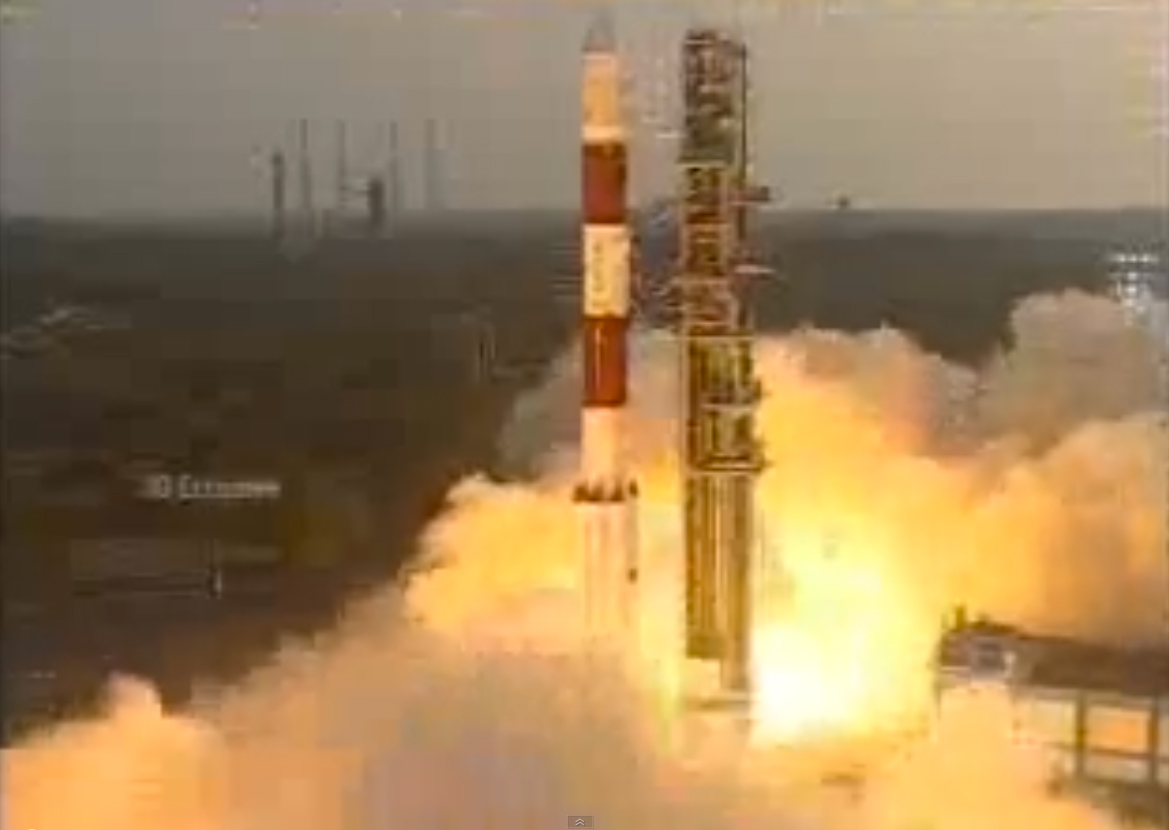
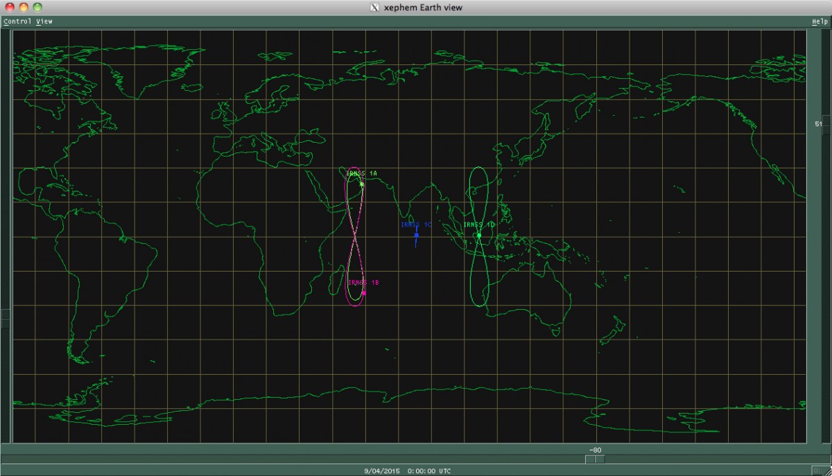
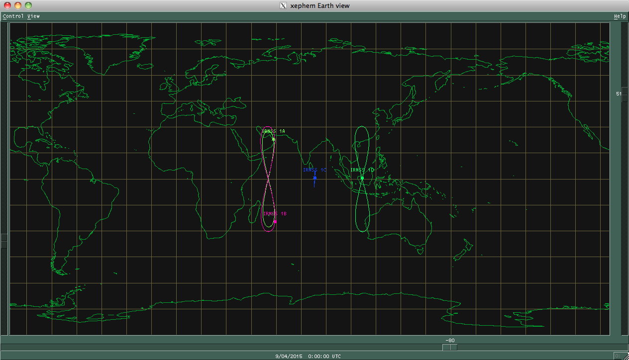
    NAVIC Clock Failures Resemble Galileo’s

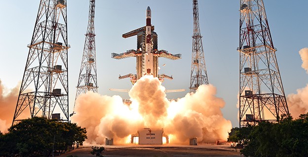
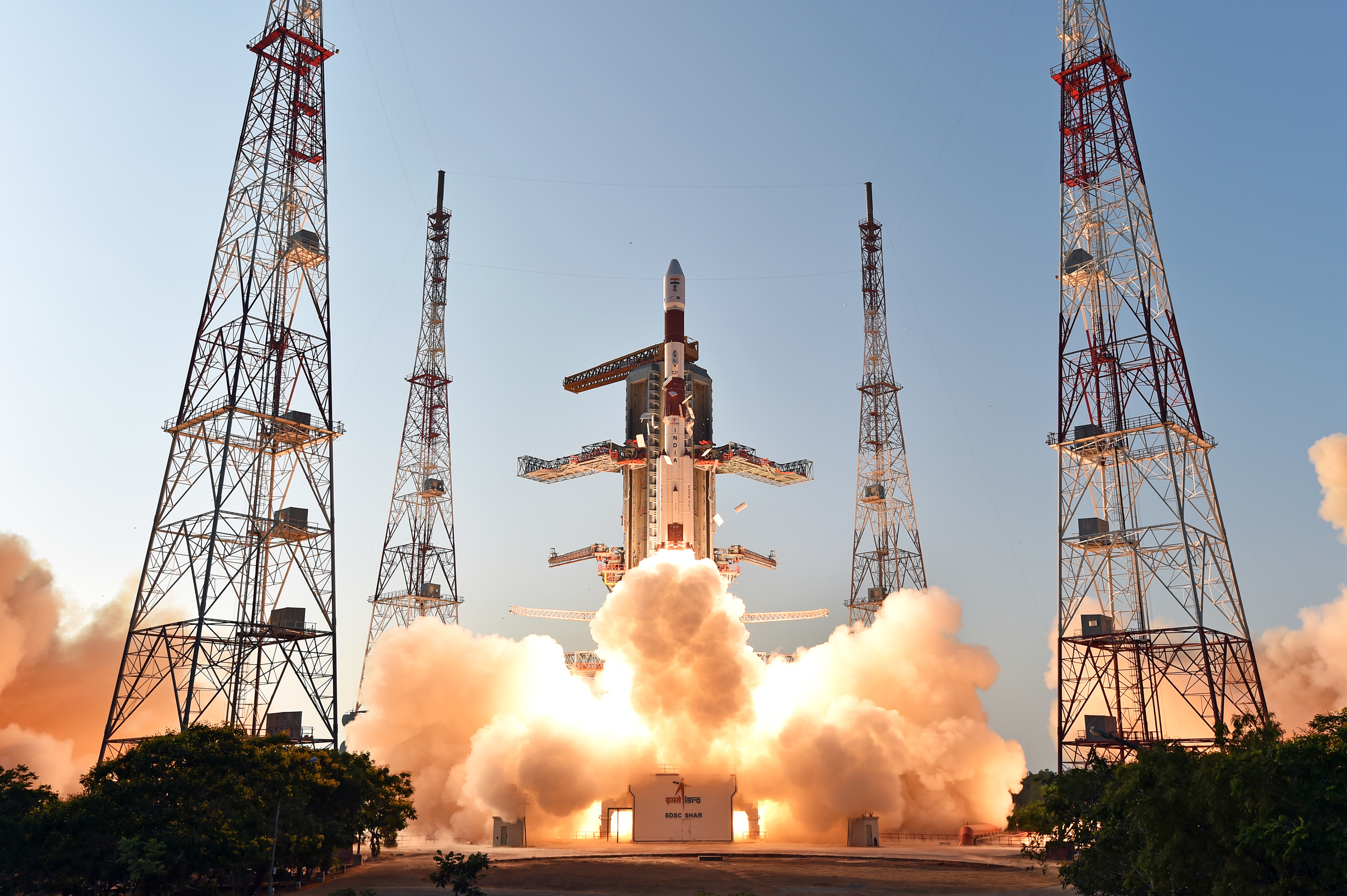
    The seven orbiting satellites of the Navigation Indian Constellation (NAVIC, formerly India’s Regional Navigation Satellite System, or IRNSS) have been hit by problems with some of their rubidium atomic clocks, similar to difficulties encountered earlier by Europe’s Galileo program.

    NAVIC G-1 launch April 2017.

    The Indian Space Research Organization (ISRO) had announced in July 2016 that all three atomic clocks on IRNSS-1A, launched in 2013, had malfunctioned, rendering that satellite ineffective.

    Now, reports indicate that four more atomic clocks on the other six satellites launched more recently are not performing as required.

    ISRO plans to launch a replacement satellite called IRNSS-1H in July-August to compensate for the loss of IRNSS-1A, although it is yet to announce the failure of more atomic clocks, which has not incapacitated the clock systems on the other six satellites.

    The European Space Agency reported in January that anomalies had occurred in three of 36 Rubidium Atomic Frequency Standard (RAFS) clocks in the 18-satellite Galileo system, although none of the satellites were affected. ESA had said, “These failures all seem to have a consistent signature, linked to probable short circuits, and possibly a particular test procedure performed on the ground.”

    ISRO has nine satellites indented for IRNSS. While seven satellites make up the Indian regional navigation constellation, the other two were indented as backup in the event of failure. Each satellite has three atomic clocks, one the primary timekeeper and the other two acting as backup.

    “Measures are being taken to correct the problems caused by the clocks in the launch of future satellites. The atomic clocks to be used in the other satellites have been modified to prevent malfunction,” a senior official in the programme said.

    ISRO chairman Kumar has indicated the number of satellites could go up from the originally envisaged seven to 11 but it is not clear if this is a consequence of the failing clocks. “We are set to launch more navigational satellites. They are in the process of approvals and clearances,” he said recently, and added efforts were on to revive the IRNSS-1A clocks.”

    In Europe, the European Space Agency and an industrial partner-supplier have agreed that “some refurbishment is required on the remaining RAFS clocks” to be used in new Galileo satellites.

    Look to GSA Service Centre for Galileo Advisories

    In July, a wide transfer of responsibilities for the Galileo constellation took place, from the European Space Agency (ESA) to the European Global Navigation Satellite System Agency (GSA) of the European Union. Key among these was a handover of communications responsibilities to manufacturers, users and markets.

    All parties can now find updates in the form of Notice Advisory to Galileo Users (NAGUs) at the GSA’s Galileo Service Centre, www.gsc-europa.eu/system-status/user-notifications.

    NAGUs are issued as new satellites are launched and when satellites become ready for service provision, or to give advance warning of signal unavailability owing to planned maintenance or testing activities, or to notify users of unplanned outages and then to inform them when satellites become active again.

    “Keeping our users in the picture on planned activities that might lead to satellite unavailabilityhas helped them to plan their own test activities and to prepare future products,” said Rafael Lucas Rodriguez, ESA’s Galileo services engineering manager.

    A total of 189 NAGUs were issued under ESA oversight in the last four years, as the constellation grew to its current 18 satellites. The user base increased from 86 to 774 registered users on the European GNSS Service Centre website as companies worked to prepare Galileo-ready products. In December 2016, Galileo’s Initial Services began operating.

    One regular consumer of Galileo NAGUs, Broadcom, uses them to organize engineering activities and tests as well as input them into its orbit prediction engine for its Long Term Orbits products.

  • ISRO inaugurates advanced GNSS research lab

    The Indian Space Research Organisation (ISRO) has launched the Advanced GNSS Research Laboratory (AGRL) in the Department of Electronics and Communication Engineering at the Osmania University College of Engineering in Hyderabad, reports The Hindu.

    ISRO Chairman A. S. Kiran Kumar inaugurated the facility on April 27. He discussed various technical aspects related to NavIC Satellite Navigation System of India (formerly the INSS).

    He also advised students and faculty to carry out research work on differential corrections, development of various modules using IRNSS, atmospheric effects, work related to mutli-constellation, kinematic applications, fisheries applications and innovative applications for the public.

    The laboratory was established to enable research projects for Ph.D., M.E. and B.E. students. It was developed under the Memorandum of Understanding (MoU) between the University College of Engineering with the Space Applications Centre (SAC), ISRO, Ahmedabad.

  • 3 atomic clocks fail on 1 Indian satellite, replacement prepped

    3 atomic clocks fail on 1 Indian satellite, replacement prepped

    IRNSS-B was launched April 4, 2014.
    IRNSS-1B, launched April 4, 2014.

    Three atomic clocks onboard a single satellite of the NAVIC Indian regional navigation satellite system have failed.

    Indian Space Research Organization (ISRO) Chairman A.S. Kiran Kumar told The Hindu newspaper that the agency is trying to restart the clocks. Kumar said the affected satellite, IRNSS-1A, is otherwise healthy, and the rest of the constellation is performing its core function of providing accurate position, navigation and time.

    Last week, the European Space Agency discussed clock failures on board Galileo satellites. Rubidium atomic clocks onboard both constellations were manufactured by Spectratime of Switzerland, but the cause of the failures has not been identified and could involve factors other than clock design.

    IRNSS-1A is equipped with one primary and two back-up clocks. At this time, it “will give a coarse value. It will not be used for computation. Messages from it will still be used,” Kumar said. “There are some anomalies in the atomic clock system on board. We are trying to restart it. Right now we are working out a mechanism for operating it.”

    The ISRO is readying one of the two back-up navigation satellites — IRNSS-1H — to replace it in space in the second half of this year. IRNSS-1A was launched in July 2013 and has an expected lifespan of 10 years.

    The Indian Regional Navigation Satellite System (IRNSS) constellation was completed April 28, 2016. It was then renamed NAVIC — Navigation Indian Constellation, by India’s Prime Minister Narendra Modi.

    With seven satellites in orbit, the constellation’s primary focus is to provide information in the Indian region and 1,500 kilometers around the mainland.

  • Indian space agency asks industry to build spare satellites

    The Indian Space Research Organisation (ISRO) is finalizing plans to have two spare satellites for its navigation fleet built by private industry in the next two years, reports The Hindu. The seven-satellite NAVIC (Navigation Indian Constellation) — formerly known as IRNSS — is now complete.

    The Indian government will “handhold” industry for the first satellite, scheduled to be built by March 2017. The second satellite will be built entirely by industry, said M. Annadurai, director of ISRO Satellite Centre. Both 1,400-kilogram spare satellites will be kept ready on the ground.

    The space agency issued “expressions of interest” in June, reports The Hindu, and ISRO is discussing details of risk, price and profit-sharing with prospective partners.

  • PlanetiQ signs weather satellite launch contract with India’s Antrix

    PlanetiQ signs weather satellite launch contract with India’s Antrix

    PlanetiQ has signed a contract with Antrix Corporation Limited, the commercial arm of the Indian Space Research Organization (ISRO), for the launch of PlanetiQ’s first two weather satellites on a Polar Satellite Launch Vehicle (PSLV) during the fourth quarter of 2016.

    Ten more satellites are planned for launch in 2017 to complete an initial set of 12 satellites that will dramatically improve global weather forecasting, climate monitoring and space weather prediction, and enable advanced analytics for numerous industries worldwide.

    The ISRO’s PSLV is among the world’s most reliable launch vehicles with 30 consecutive successful flights. It has launched 51 satellites for international customers from 20 countries, in addition to 33 Indian national satellites.

    “The stellar track record of the PSLV combined with our seven-year satellite design life provides the reliability and data continuity not just desired, but required by the operational weather forecast community,” said Chris McCormick, Chairman and CEO of PlanetiQ. “Within days after launch, we will validate and start delivering high-quality data and services to our customers.”

    24 hours of data from 12 PlanetiQ satellites = ~34,000 occultations/day.
    24 hours of data from 12 PlanetiQ satellites = ~34,000 occultations/day.

    Each of PlanetiQ’s 10-kilogram microsatellites will fly PlanetiQ’s Pyxis-RO sensor, an advanced satellite weather sensor in a small package that can penetrate through clouds and storms down to the Earth’s surface. Pyxis-RO uses a technique called radio occultation to track the bending of GPS and other signals as they travel through Earth’s atmosphere, and then converts the bending angle into high-precision measurements of global temperature, pressure and water vapor in the atmosphere, and electron density in the ionosphere.

    Pyxis-RO quadruples the data collection capability of radio occultation sensors on orbit today by tracking signals from all four major satellite navigation systems — GPS, Galileo, Beidou and GLONASS. With 12 satellites on orbit, PlanetiQ will collect 34,000 occultations per day, evenly distributed around the globe with high-density sampling over both land and water.

    Each occultation is a vertical profile of atmospheric data with high vertical resolution, comprised of measurements less than every 200 meters from the Earth’s surface up into the ionosphere. The data is similar to that collected by weather balloons, but more accurate, more frequent and on a global scale.

    “The world today lacks sufficient data to feed into weather models, especially the detailed vertical data that is critical to storm prediction. That’s why we see inaccurate or ambiguous forecasts for storms like Hurricane Joaquin, which can put numerous lives at risk and cost businesses millions of dollars due to inadequate preparation or risk management measures,” McCormick said. “Capturing the detailed vertical structure of the atmosphere from pole to pole, especially over the currently under-sampled oceans, is the missing link to improving forecasts of high-impact weather.”

  • ISRO: All 7 IRNSS Satellites in Orbit by March

    All seven satellites of Indian Regional Navigation Satellite System (IRNSS) are expected to be in orbit by March 2016, reports New Delhi Television, citing Indian Space Research Organisation (ISRO) Chairman Kiran Kumar.

    “We expect by March 2016 all the seven constellation of IRNSS to be in orbit,” Kumar said.

    Four IRNSS satellites are now in orbit, with three remaining to complete the system. The next IRNSS satellite, 1E, is scheduled for launch in November, and 1F is set for launch in December.

    Also, the GSAT-15 satellite, which has a GAGAN payload, will be launched on Nov. 10.

    Kumar made his comments after inaugurating GNSS User Meet 2015 at the ISRO Satellite Centre (ISAC) in Bengaluru, India. The event was jointly organized by ISRO and Airports Authority of India (AAI).


  • IRNSS-1D Reaches Orbital Slot

    IRNSS-1D Reaches Orbital Slot

    Photo: IRNSS-1D

    News courtesy of CANSPACE Listserv.

    The fourth satellite in the Indian Regional Navigation Satellite System, launched on March 28, has arrived at its designated orbital slot.

    Based on data supplied by the U.S. Joint Space Operations Center, IRNSS-1D is in an inclined geosynchronous orbit with an inclination of 30.5 degrees and a nodal longitude of 111.7 degrees east, within the allowed limits of the assigned longitude of 111.5 degrees east.

  • India’s IRNSS-1D Launched into Orbit

    India’s IRNSS-1D Launched into Orbit

    IRNSS-1D-1-launch
    Photo credit: ISRO

    The fourth satellite of IRNSS satellite navigation constellation, IRNSS-1D, was launched onboard PSLV-C27 on Saturday, March 28, according to the Indian Space Research Organization (ISRO). The Polar Satellite Launch Vehicle blasted off at 11:49 GMT (7:49 a.m. EST), or 5:19 p.m. local time, at the Satish Dhawan Space Center on India’s east coast.

    This is the fourth successful launch of a navigation satellite in less than a week, following GPS IIF-9 on Wednesday and Galileo 7 and 8 on Friday. A fifth navigation satellite, for the BeiDou constellation, is expected to launch tomorrow.

    This is the 28th consecutively successful mission of the PSLV, the ISRO said. The “XL” configuration of PSLV was used for this mission. Previously, the same configuration of the vehicle was successfully used seven times.

    After the PSLV-C27 lift-off with the ignition of the first stage, the subsequent important flight events took place as planned. After a flight of about 19 minutes, 25 seconds, the IRNSS-1D satellite was injected to an elliptical orbit of  282.52 km X 20,644 km, very close to the intended orbit, and successfully separated  from the PSLV fourth stage.

    After injection, the solar panels of IRNSS-1D were deployed automatically. ISRO’s Master Control Facility (at Hassan, Karnataka) took over the control of the satellite. In the coming days, four orbit maneuvers will be conducted from the Master Control Facility to position the satellite in geosynchronous orbit at 111.75 degrees East longitude with 30.5 degrees inclination.

    IRNSS-D is the fourth of seven IRNSS satellites to be launched to provide navigational services to the region, according to the ISRO. The satellite was placed in geosynchronous orbit. Predecessors IRNSS-1A, 1B and 1C were launched by PSLV-C22, PSLV-C24 and PSLV-C26 in July 2013, April 2014 and October 2014 respectively. All the satellites are functioning satisfactorily from their designated orbital positions.

    The IRNSS navigational system is regional, and targeted towards South Asia. The satellite will enable navigation, tracking and mapping services.

    The next satellite, IRNSS-1E, is scheduled to be launched by PSLV. The entire IRNSS constellation of seven satellites is planned to be completed by 2016.

    IRNSS-1D-2-launch
    Photo credit: ISRO
    IRNSS-1D-3-launch
    Photo credit: ISRO
  • Launch of IRNSS-1D Now Set for Saturday

    The launch of India’s fourth Navigation Satellite, IRNSS-1D, is now scheduled for 17:19 IST (11:49 UTC) on Saturday, March 28, from Satish Dhawan Space Centre, Sriharikota.

    The launch was previously scheduled for March 9, then postponed until March 29 to replace a faulty telemetry transmitter on the satellite, according to the Indian Space Research Organization.

    IRNSS-1D will be fourth in the seven-spacecraft Indian Regional Navigation Satellite System constellation. It will be flown into space in the Indian Polar Satellite Launch Vehicle-XL.

    The space segment of the IRNSS consists of seven satellites: three  in geostationary orbit and four in inclined geosynchronous orbit. The ground segment consists of infrastructure for controlling, tracking and other facilities. The entire IRNSS constellation of seven satellites is planned to be completed by 2015.

    Both IRNSS-1A and 1B are functioning satisfactorily from their designated geosynchronous orbital positions. The first three satellites in the IRNSS series were launched from Sriharikota on July 1, 2013, April 4, 2014, and October 16, 2014. IRNSS-1E and IRNSS-1F satellites are expected to be launched before year end.

    IRNSS is an independent regional navigation satellite system designed to provide position information in the Indian region and 1,500 kilometers around the Indian mainland. IRNSS will provide two types of service: Standard Positioning Services (SPS) — provided to all users — and Restricted Services (RS), provided to authorized users.


  • ISRO to Launch Fourth Navigation Satellite March 9

    The Indian Space Research Organization (ISRO) is expected to launch IRNSS-1D on March 9, reports The Times of India. IRNSS-1D is the fourth navigation satellite in the Indian Regional Navigational Satellite System, and will make the constellation operable.

    The launch is tentatively planned for March 9 around 6:35 p.m. However, final go for the launch will be given by the ISRO’s Launch Authorization Board, which will meet March 6.

    IRNSS-1D will be flown into space in the Indian Polar Satellite Launch Vehicle-XL.

    The space segment of the IRNSS consists of seven satellites: three  in geostationary orbit and four in inclined geosynchronous orbit. The ground segment consists of infrastructure for controlling, tracking and other facilities. The entire IRNSS constellation of seven satellites is planned to be completed by 2015.

    Both IRNSS-1A and 1B are functioning satisfactorily from their designated geosynchronous orbital positions. The first three satellites in the IRNSS series were launched from Sriharikota on July 1, 2013, April 4, 2014, and October 16, 2014. IRNSS-1E and IRNSS-1F satellites are expected to be launched before year end.

    IRNSS is an independent regional navigation satellite system designed to provide position information in the Indian region and 1,500 kilometers around the Indian mainland. IRNSS will provide two types of service: Standard Positioning Services (SPS) — provided to all users — and Restricted Services (RS), provided to authorized users.