Tag: Juniper Systems

  • Launchpad: GNSS firewall, drone rescue, modules and mappers

    Launchpad: GNSS firewall, drone rescue, modules and mappers

    A roundup of recent products in the GNSS and inertial positioning industry from the November 2018 issue of GPS World magazine.

    OEM

    Simulator signals

    GPS L5 and Galileo E5 added to simulator

    Rohde & Schwarz adds GPS L5 and Galileo E5 simulation capabilities to the R&S SMW200A GNSS simulator. (Photo: R&S)
    Photo: Rohde & Schwarz

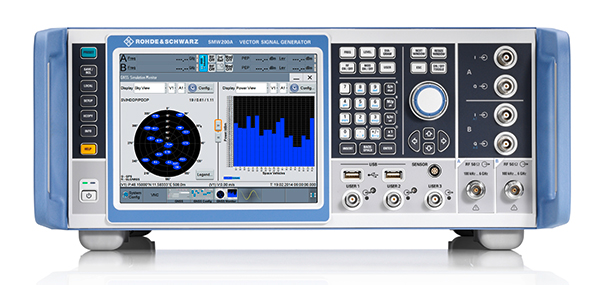
    Rohde & Schwarz has added GPS L5 and Galileo E5 simulation capabilities to its R&S SMW200A GNSS simulator. The R&S SMW200A GNSS simulator is designed for efficient test and characterization of multi-constellation and multi-frequency GNSS receivers. It now enables generation of complex and highly realistic test scenarios with up to 144 channels in the GNSS frequency bands L1, L2 and L5. In addition to GPS (L1/L2/L5), GLONASS (L1/L2), Galileo (E1/E5) and BeiDou (L1/L2), the R&S SMW200A also supports signal generation for QZSS and SBAS on L1. Channels can be routed to up to four RF outputs, so that even multi-antenna systems can be tested. The R&S SMW200A can generate complex coexistence and interference scenarios with multiple interferers.

    Rohde & Schwarz, rohde-schwarz.com

    GNSS firewall

    Provides secure, continuous timing integrity

    The BlueSky GNSS Firewall enables critical infrastructure providers to harden the security of their operations from GPS threats and deliver a more reliable and secure service. The security-hardened system provides protection against GPS threats such as jamming, spoofing and complete outage. It also supports a range of precision timing technologies, including atomic clocks, to enable continuous operation when GPS may be completely denied for extended periods. The TimePictra software management suite provides centralized control and visibility of GPS reception across regional, national and global geographic areas. It can incorporate an optional internal miniature atomic clock.

    Microsemi, microsemi.com

    GNSS antenna

    For reference deployments, CORS networks and monitoring

    The VeraChoke GNSS antenna. (Photo: Tallysman)
    The VeraChoke GNSS antenna. (Photo: Tallysman)

    The VeraChoke is a high-accuracy choke ring antenna with a choice in form factor for reference and monitoring applications. The VC6100, the first model variant of the VeraChoke, shares a common high-efficiency element design with its counterpart VeraPhase. With the choke-style form-factor, however, the rings have been optimized for all GNSS signals and are slightly pyramidal in shape to improve reception of low-elevation satellites. The VC6100 offers a tight phase center variation (PCV) of no more than ±1 mm for every frequency. It is capable of receiving all GNSS signals, and achieves a very low axial ratio. The antenna also supports large and small SCIGN radomes.

    Tallysman, www.tallysman.com

    GNSS + INS module

    Combination improves availability

    Duro Inertial fuses GNSS and inertial measurements into a combined solution. (Photo: Swift Navigation)
    Photo: Swift Navigation

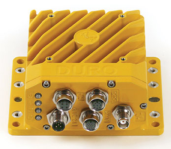
    Duro Inertial is a ruggedized version of Swift Navigation’s Piksi Multi dual-frequency real-time kinematic (RTK) GNSS receiver combined with Carnegie Robotics’ SmoothPose sensor fusion algorithm, which fuses GNSS and inertial measurements into a combined solution. The blending of GNSS and inertial measurements provides a dead-reckoning capability that allows Duro Inertial to provide a highly accurate, continuous position solution during brief GNSS outages and to deliver a robust precision navigation solution in harsh GNSS environments.

    Swift Navigation, www.swiftnav.com; Carnegie Robotics, carnegierobotics.com

    Smartwatch

    Features GPS, GLONASS and Galileo

    Photo: Garmin
    Photo: Garmin

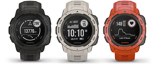
    The durable Instinct has GNSS; three-axis compass; barometric altimeter; and wrist-based heart-rate sensor. The watch includes a built-in sports apps, smart connectivity and wellness data. It is built to endure challenging environments, and is constructed to military standards for thermal, shock and water resistance. The multi-GNSS feature helps users track their location in challenging environments, while the Garmin Explore app helps plan and track a trip.

    Garmin, garmin.com

    SURVEY & MAPPING

    Navigation system

    GNSS + inertial for surveying

    Photo: SBG Systems
    Photo: SBG Systems

    The Navsight Land & Air Solution provides high-performance inertial navigation to make surveyors’ mobile data collection easier, whether for mobile mapping, GIS or road inspection. The solution consists of an inertial measurement unit (IMU), available at two different performance levels, connected to Navsight, a rugged processing unit embedding fusion intelligence and a GNSS receiver. It also has connections for external equipment such as lidar, cameras or computer. SBG’s fusion algorithms allow the company to get the best performance from inertial, odometer and GNSS technologies; exclude false GNSS fixes; and improve the trajectory in complicated areas such as urban canyons, forests and tunnels. The solution supports all GNSS constellations, and real-time kinematic (RTK) and precise point positioning services such as Omnistar and TerraStar.

    SBG Systems, www.sbg-systems.com

    Mapper

    Edge-to-cloud big data system

    iSTAR Pulsar is designed to capture 360-degree data while mounted on a vehicle, drone or on foot. An upcoming feature in cloud-based processing software VR.WORLD uses artificial intelligence and image recognition to analyze the images captured by iSTAR Pulsar so that objects like cars, trucks, traffic lights, road signs, pedestrians and cyclists can be automatically identified in images. Handheld 3D mobile mapping company GeoSLAM and mobile mapping software company Orbit GT have introduced integration with iSTAR Pulsar.

    NCTech, www.nctechimaging.com

    Smart antennas

    Offers L-band access to TerraStar

    Photo: NovAtel
    Photo: NovAtel

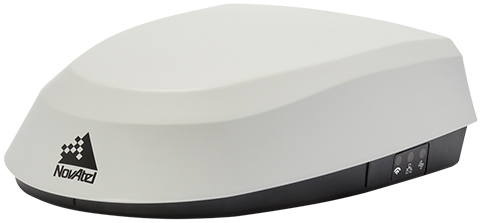
    The SMART7 family features NovAtel’s GNSS + inertial navigation system (INS) SPAN technology; future-ready GNSS; Wi-Fi and internet protocol connectivity; superior tracking performance; and TerraStar-C PRO corrections. It is designed to increase GNSS availability, accuracy and reliability for major precision-agriculture equipment manufacturers. The SMART7-S includes SPAN technology, the SMART7-W includes Wi-Fi and an integrated NTRIP client, and the SMART7-I model also incorporates Ethernet. All SMART7 models provide exceptional positioning availability using signals from all constellations and frequencies to deliver assured positioning anywhere.

    NovAtel, www.novatel.com

    Rugged tablet

    For high-accuracy measurements

    Photo: DT Research
    Photo: DT Research

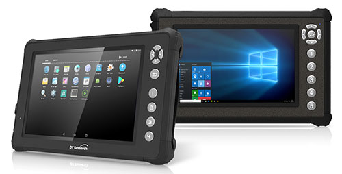
    The DT301X rugged military-grade tablet is purpose-built to enhance the precision of 3D surveying, crime and crash scene reconstruction, and bridge and other construction inspections. An option is a dual-frequency GNSS module for real-time mapping and positioning. The tablet integrates the Intel RealSense depth camera, which provides real-time 3D imaging providing accurate measurements for CAD, engineering, design, utility management and crime-scene forensics. A high brightness 10.1-inch touchscreen offers flexible viewing in a wide range of lighting, and an Intel eighth-generation Core i5 or i7 processor offers high-performance while still being energy efficient. With high-capacity 60- or 90-watt hot-swappable batteries, the DT301X keeps working continuously, complemented with a variety of battery chargers so fully charged batteries are always available.

    DT Research, www.dtresearch.com
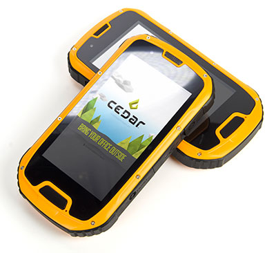
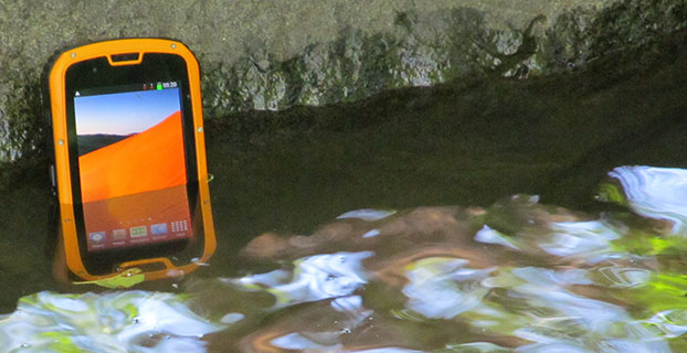
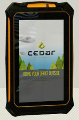
    Rugged smartphone

    For data collection

    Photo: Juniper Systems
    Photo: Juniper Systems

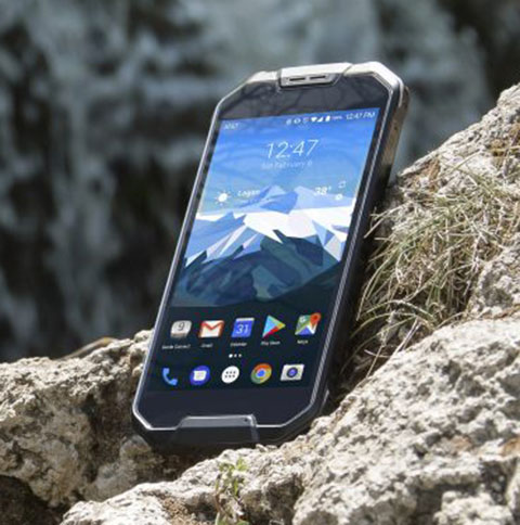
    The Cedar CP3 rugged smartphone is capable of data collection and communication. It has a high-visibility 5.5-inch AMOLED display; 14- to 16-hour battery life operating at full brightness and running GPS; 16-megapixel user-facing camera and dual 12-megapixel rear camera; and 6 gigabytes of RAM with 64 gigabytes of internal storage.

    Juniper Systems, www.junipersys.com

    UAV

    Drone rescue system

    Parachute systems for multicopters

    Photo: Drone Rescue
    Photo: Drone Rescue

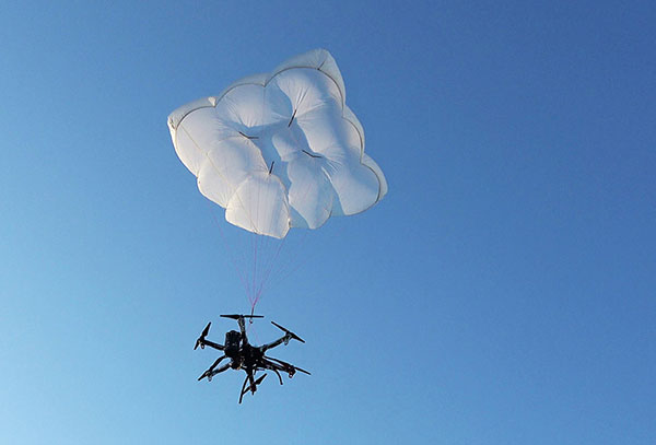
    Parachute rescue system DRS-5 is designed for multicopters up to 8 kg; the DRS-10 for multicopters weighing 5–20 kg. The system consists of a carbon cage in which the parachute is stored as well as associated electronics. The electronics, including the sensors, monitor the flight status of a drone independent of the flight controller. A sophisticated algorithm merges this sensor data, enabling automatic crash detection and parachute ejection. All flight data and movements are recorded in a black box.

    Drone Rescue, www.dronerescue.com

    UAV data analysis tool

    New analytics tool for drone pilots

    PrecisionPass assesses UAV data collected in the field. The toolkit lets pilots quickly determine if a data-collection job meets the required criteria or if it needs to be collected again. PrecisionPass assesses coverage, assesses image resolution and quality, reviews required metadata, speeds upload and processing times, and packages data for processing. The immediate feedback reduces the risk of failures during the analysis stage, all but eliminating the need to re-fly a mission, so customer needs are met in a timely and cost-efficient manner.

    Harris Geospatial, www.harrisgeospatial.com

    Computing platform

    Automates commercial drone tasks

    The Skyfish platform is controlled by the tiny SkyNode computer, which integrates with optical, thermal, navigational and lidar devices along with sensors, algorithms and robotics. (Photo: Skyfish)
    Photo: Skyfish

    The Skyfish computing platform fully automates crucial infrastructure inspection and measurement tasks. It supports DJI and PixHawk flight controllers and other drone architectures, as well as 3D modeling software from companies such as Bentley Systems. Its easy-to-use interface enables anyone to fly, inspect and model complex infrastructure. The platform also pre-processes the collected infrastructure data and metadata to help create impeccable 3D models.

    Skyfish, www.skyfish.ai

    TRANSPORTATION

    Development kit

    Open-source GNSS+IMU kit for autonomous guidance

    Photo: Aceinna
    Photo: Aceinna

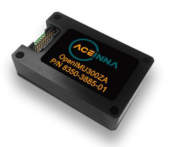
    OpenIMU is a professionally supported, open-source GPS/GNSS-aided inertial navigation software stack for low-cost precise navigation applications. Integrating an inertial measurement unit (IMU)-based sensor network improves navigation and self-location capabilities. It is aimed at developing autonomously guided vehicles for industrial applications, autonomous cars, industrial robots and drones. OpenIMU enables advanced localization and navigation algorithm solutions; its extensible software infrastructure provides the code needed for algorithm development. A hardware development kit includes JTAG-pod, precision mount fixture, EVB and an OpenIMU300 module that features Aceinna’s 5 deg/hr, 9-Axis gyro, accelerometer and magnetometer sensor suite with an onboard 180-MHz ARM Coretex floating-point CPU.

    Aceinna, aceinna.com

    GNSS module

    Leverages the Teseo III receiver

    Image: STMicroelectronics
    Image: STMicroelectronics

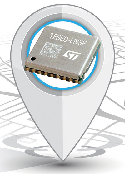
    The Teseo-LIV3F module incorporates the Teseo III receiver. It speeds application development and adds up to 16 MB of Flash memory for firmware updating or data logging without a backup battery. Used by automotive and industrial sectors, the Teseo III multi-constellation receiver combines high accuracy with fast response time and low power consumption. The Teseo-LIV3F module enables makers and small engineering teams to leverage the Teseo III advantages in creating new products in the industrial and consumer market segments such as vehicle trackers, drones, anti-theft devices and pet locators, and systems for services such as fleet-management, tolling, vehicle sharing or public transportation.

    STMicroelectronics, www.st.com

    Digital mirrors

    Coming to Europe in late 2018

    Photo: Ficosa
    Photo: Ficosa

    Audi’s latest e-tron electric car will launch in Europe with a digital rear-view system. Developed by Ficosa, the camera monitoring system is made up of cameras and displays that replace traditional external side mirrors to increase safety and comfort. The vision system is comprised of two cameras, integrated into the sides of the car’s chassis, and two tactile displays inside the doors.

    Ficosa, www.ficosa.com; Audi, www.audi.com

  • HarvestMaster releases field applicator for improved efficiency

    Harvestmaster-W

    HarvestMaster, provider of agricultural data collection solutions, has introduced a new field applicator that applies various treatments to specific field plots. The field applicator is easily controlled from within HarvestMaster’s Mirus field data-collection software using a software plugin.

    Using the Mirus field applicator plugin, users can select which treatments to apply to individual plots from within the Mirus dashboard, and can choose to control the field applicator either manually or automatically, based on GPS location. The system significantly reduces error in treatment applications and improves productivity by streamlining the application process in the field, according to Juniper Systems, parent company of HarvestMaster.

    Compatible with a wide range of research spray systems, the Mirus field applicator plugin eliminates the usual bulky and often confusing toggle switch boxes that are typically used to control field applicators. The user imports a file that specifies which formulation is to be applied to each plot, then selects whether to control the applicator either manually or through GPS positioning data, and the system is ready to go.

  • Juniper Systems launches Windows 10 rugged tablet

    Windows 10 and a new large display are key features of Juniper Systems’ latest tablet, Mesa 2 Rugged Tablet, released today.

    Juniper Systems is a provider of ultra-rugged field data collection solutions.

    Featuring the largest display produced by Juniper Systems to date, the Mesa 2 is also Juniper Systems’ first handheld to run on the new Windows 10, which the company said allows for improved decision-making in the field, as well as smooth transitioning from field data collection to office work and back.

    With a full Windows 10 operating system, the Mesa 2 provides users with access to a broader range of software options to meet their data collection needs and is powerful enough to use in place of a desktop computer when in the office. The Mesa 2’s 7-inch display strikes a perfect balance between providing ample viewing area for collected data and reducing overall weight for minimal fatigue and superior, all-day comfort, the company said.

    The Mesa 2 is designed to perform reliably in harsh environments, and is the only IP68-rated rugged Windows tablet available, providing complete protection against water and dust. It maintains a seal while its ports are in use, while most other tablets on the market are exposed to damage from water and dust if the port cover is not securely in place.

    The Mesa 2 also features an extraordinary IllumiView display, providing best-in-class visibility in any lighting conditions, and its chemically-strengthened Dragontrail glass touch screen provides superior durability, reducing haze from surface scratches and cracks normally caused by accidental impact.

    The Mesa 2 battery provides users with a full 8-10 hours of runtime, allowing for maximum productivity throughout the workday. Users may also purchase an optional expansion battery from Juniper Systems that provides an additional 4-5 hours of runtime plus hot swap capabilities for those extra-long days where overtime is required.

    “The Mesa 2 is in a new sphere relative to our other ultra-rugged devices,” said Nate Holman, Director of Sales and Marketing at Juniper Systems. “While it features the same degree of outstanding quality and ruggedness as other Juniper products, the Mesa 2 provides users with more software options and greater processing capabilities, due to its full Windows 10 operating system and Intel quad-core processor. The Mesa 2 is designed to improve productivity along every point of the data collection process, from the initial planning and gathering of data, to the later data analysis, and finally through the decision-making process. It’s a tablet optimized for efficiency, designed to be ‘your office, anywhere’.”

    The Mesa 2 Rugged Tablet will begin shipping in the first quarter of 2016.

  • Juniper to Exhibit Sub-Meter GPS Solution at Esri User Conference

    Juniper to Exhibit Sub-Meter GPS Solution at Esri User Conference

    Photo: Juniper Systems 

    Juniper Systems is exhibiting its sub-meter GPS solution using Esri ArcPad, Effigis’ EZSurv Post-Processing software, and its ultra-rugged handheld computers — a combination the company says is budget-friendly and easy-to-use — at the Esri User Conference, being held in San Diego July 20–24.

    The sub-meter solution involves collecting GIS data using a Juniper Systems rugged handheld running ArcPad data collection software, and then using Effigis’ EZSurv software to post-process the data, resulting in sub-meter GPS accuracy. Users can import and export data, including custom attributes, from their GIS. The data collection process bypasses the need for expensive survey-grade GPS receivers, providing both an affordable and simple solution for professionals who require sub-meter accuracy, Juniper Systems said.

    “This solution is a great option for people looking for sub-meter accuracy without the steep price,” said Trevor Brown, Natural Resources market manager at Juniper Systems. “The range of applications that can benefit from this type of solution is very broad, with uses in forestry, agriculture, environmental monitoring, and asset management, to name a few. And not only is it inexpensive, it’s also super simple. You can have sub-meter accuracy with the click of a button.”

    Those attending the Esri User Conference can see this affordable sub-meter solution at Juniper Systems’ booth #2212. The data sheet can be downloaded,  or visit Juniper Systems’ website to learn more.

  • Why Physical Keyboards Haven’t Gone Out of Style on Rugged Handhelds

    As most electronics manufacturers make the move away from physical keyboards and towards solely touch interfaces, rugged handheld manufacturer, Juniper Systems, says physical keyboards still have a place in the rugged data collection world — especially for applications that involve high volumes of data entry. In a recent blog post, Juniper Systems names several key benefits that physical keyboards offer for data collection, that entirely touch interfaces simply can’t provide.

    Archer-2-cropped_mediumIn the blog post called “Why Physical Keyboards Haven’t Gone Out of Style on Rugged Handhelds,” Juniper Systems lists the following benefits offered by a handheld with physical keys:

    • Faster data entry – Keying in data is much faster when there’s no worry of inadvertently touching the wrong part of the screen.
    • Higher accuracy – Physical keys provide direct tactile feedback response, reducing the number of errors in data entry.
    • Rapid, non-visual data entry – Some data collectors get so comfortable with the keyboard (like many log scalers, for example), that they can rapidly enter in data without even looking at the keys.
    • Safety – Using non-visual data entry, workers spend less time with their heads down, allowing for increased awareness of their surroundings.
    • Reliability – Physical keyboards are not subject to weather conditions, as on-screen keyboards are. Rain, snow, and dirt can affect a touch screen’s responsiveness, and bright sunlight can affect visibility. Physical keyboards provide reliable performance in any conditions.
    • Productivity – Physical keys can be programmed to carry out background tasks with the press of a button.

    “We design our handhelds to maximize efficiency and productivity for data collection, and sometimes that might mean diverging from what the consumer electronics industry is doing,” said John Florio, product manager at Juniper Systems. “In this case, that means retaining a physical keyboard on our handhelds used for data-intensive applications, providing important benefits to those customers that they just can’t get from on-screen keyboards.”

    Juniper Systems points to the physical keys featured on its Allegro 2 and Archer 2 handhelds, both of which are designed for data-intensive applications. Read Juniper Systems’ full blog post here. 

  • Cedar Tree Handhelds Now Under Juniper Systems

    CT4-Handheld-W
    The CT4 and other rugged handhelds by Cedar Tree Technologies will now be available through Juniper Systems.

    Juniper Systems is merging its subsidiary company, Cedar Tree Technologies, into Juniper Systems. The move will allow customers to purchase Cedar’s Android-operated rugged handhelds directly from Juniper Systems.

    Juniper Systems launched Cedar Tree Technologies as a rugged handheld company in August 2014.

    “With a reputation for top-of-the-line, ultra-rugged handheld computers, Juniper Systems aimed to expand its products to meet the needs of customers who may not need the outstanding level of ruggedness or support that Juniper handhelds provide. And that’s how Cedar Tree Technologies began. Cedar handhelds lie somewhere between consumer devices and Juniper Systems’ ultra-rugged handhelds, providing a mesh of both ruggedness and affordability,” said a statement from the company.

    Cedar handhelds run on the Android operating system, offering access to thousands of business-ready apps and Google services via the Google Play Store. This provides users with an off-the-shelf product, eliminating the need to download third-party data collection software. Juniper Systems has published a blog post that outlines the differences between Cedar and Juniper handhelds.

    The Cedar product line that Juniper Systems will now be carrying includes three new handheld devices:

    • CT7 Rugged Tablet. Featuring a large, 7-inch display, the CT7 tablet is IP67 waterproof and dustproof, and is priced at $899 USD.
    • CT4 Rugged Handheld. The CT4 handheld is a more compact device than the CT7. Featuring a 4.3-inch display and an IP68 waterproof and dustproof rating, it is priced at $489.
    • CMP1 Miniphone. The CMP1 Miniphone is rated IP65 (dustproof and resistant to water), and is ideal for swapping out a regular smartphone for outdoor excursions, for kids, or for use as an emergency phone. The CMP1 sells for $124.

    To learn more about Juniper Systems’ new Cedar handhelds, visit the company website.

  • Juniper Systems Pulls Cedar Tree Under Its Banner

    Juniper Systems Pulls Cedar Tree Under Its Banner

    CT4-Handheld-W
    The CT4 and other rugged handhelds by Cedar Tree Technologies will now be available through Juniper Systems.

    Juniper Systems is merging its subsidiary company, Cedar Tree Technologies, into Juniper Systems. The move will allow customers to purchase Cedar’s Android-operated rugged handhelds directly from Juniper Systems.

    Juniper Systems launched Cedar Tree Technologies as a rugged handheld company in August 2014.

    “With a reputation for top-of-the-line, ultra-rugged handheld computers, Juniper Systems aimed to expand its products to meet the needs of customers who may not need the outstanding level of ruggedness or support that Juniper handhelds provide. And that’s how Cedar Tree Technologies began. Cedar handhelds lie somewhere between consumer devices and Juniper Systems’ ultra-rugged handhelds, providing a mesh of both ruggedness and affordability,” said a statement from the company.

    Cedar handhelds run on the Android operating system, offering access to thousands of business-ready apps and Google services via the Google Play Store. This provides users with an off-the-shelf product, eliminating the need to download third-party data collection software. Juniper Systems has published a blog post that outlines the differences between Cedar and Juniper handhelds.

    The Cedar product line that Juniper Systems will now be carrying includes three new handheld devices:

    • CT7 Rugged Tablet. Featuring a large, 7-inch display, the CT7 tablet is IP67 waterproof and dustproof, and is priced at $899 USD.
    • CT4 Rugged Handheld. The CT4 handheld is a more compact device than the CT7. Featuring a 4.3-inch display and an IP68 waterproof and dustproof rating, it is priced at $489.
    • CMP1 Miniphone. The CMP1 Miniphone is rated IP65 (dustproof and resistant to water), and is ideal for swapping out a regular smartphone for outdoor excursions, for kids, or for use as an emergency phone. The CMP1 sells for $124.

    To learn more about Juniper Systems’ new Cedar handhelds, visit the company website.

  • Juniper’s New Rugged Handheld Designed for Data-Collecting Efficiency

    The Allegro 2 by Juniper Systems. Photo: Juniper Systems
    The Allegro 2 by Juniper Systems. Photo: Juniper Systems

    Juniper Systems announced its newest rugged handheld computer, the Allegro 2, at the InterGeo 2014 trade show, held September 7-9 in Berlin. The handheld is the latest in the company’s Allegro product line, “with every bit of reliability,” the company says, but now with some major advancements.

    According to Juniper Systems, the Allegro 2 was designed for data-intensive applications, with meticulous attention paid to the engineering and design of the handheld to maximize efficiency and precision, both of which are critically important to high-volume data collection.

    Compared to the Allegro 1, the Allegro 2 has a newly designed keyboard in a QWERTY and numeric layout, with large, glove-friendly buttons for rapid — even non-visual — data entry. The new handheld features a custom Sun-to-Shade display that is 20 percent larger than the previous Allegro. It offers excellent visibility in any lighting conditions, the company said.

    The Allegro 2 is powered by an Overtime Technology battery, providing a 20+ hours of runtime. Its touchscreen uses capacitive technology, providing excellent durability, as well as crystal-clear imagery and greater sensitivity to touch, Juniper Systems said. The Allegro 2 has significantly enhanced GNSS performance, extended Bluetooth range, camera and video options, and a more powerful processor than the Allegro 1.

    “The Allegro 2 is our next-generation product, and it includes all of the latest enhancements available in its sister product, the Archer 2,” said John Florio, product manager at Juniper Systems. “The Allegro 2 was built from the ground up, based on user feedback on the jobs they have to do. Whether the customer is grading lumber in a log scaling yard, running a robotic total station, or performing a close-interval pipeline survey, the Allegro 2 is the best solution for the field today.”

    The Allegro 2 is scheduled to begin shipping in November.


  • Juniper Systems, Soil Instruments Partner on Geotechnical Monitoring

    Soil Instruments Limited has partnered with Juniper Systems Limited to provide a geotechnical monitoring system using rugged computers and geotechnical engineering instrumentation to improve field activities in the structural and earthworks industry.

    Pairing Juniper Systems’ Archer 2 rugged field computer with Soil Instruments’ Digital Inclinometer Systems provides field engineers with a robust measuring and data collection system, the companies said.

    Soil Instruments’ Digital Bluetooth Inclinometer Systems are now exclusively using Juniper Systems’ Archer 2 rugged computer, which provides superior readings and data capture, Soil Instruments said. Soil Instruments’ inclinometers are specially designed instruments that provide high accuracy and resolution measurement for the monitoring of structural and earth deformations, movements or settlement.

    “The rugged Archer 2 handheld computer pairs beautifully with Soil Instruments’ Digital Inclinometers, providing more accurate readings and data capture than could ever be achieved previously in this industry,” said Simon Bowe, general manager of Juniper Systems Limited.

    Juniper Systems’ Archer 2 rugged computer is connected to the inclinometer system via Bluetooth wireless technology. Within the borehole an angular reading is produced by the engineer via the Read button on the Archer 2 screen, which triggers the inclinometer sensors to take the reading.

    Those readings are then instantly transmitted via the Bluetooth connection to the Archer 2, captured on-screen and saved in the Archer 2’s database, to be reviewed for accuracy or other needed data measurements. Long days of field work remain productive because of the 512MB of RAM and 8GB of flash storage in the Archer 2.

    Data can also be transmitted back to base quickly and accurately via the 3.75G modem in the Archer 2, an action which many other inclinometers cannot complete. At the end of the day, data can be downloaded or transmitted for subsequent comparison against all previous borehole runs, allowing analysis of lateral ground movements over time.

    “Soil Instruments has found the perfect field computer to match with our Digital Inclinometer Systems”, said Mike Ziolek, sales and marketing director for Soil Instruments. “The Archer 2 really gives our customers an edge by providing field readings more quickly and clearly than any other inclinometer system.”

    The physical features of the Archer 2 and the Inclinometer Systems are highly compatible. The Archer 2’s IllumiView high-visibility display is extra large, incredibly bright, and overpowers glaring sunlight. The backlit LCD easily adjusts to either portrait or landscape orientation, and is glove-friendly and extremely scratch-resistant.

    The Archer 2 has ultra-rugged construction with IP68 protection against water and dust, and is shockproof against multiple drops. The intelligent Li-ion battery can operate up to 20 hours on one charge and is hot-swappable in the field. The high-sensitivity GPS/GLONASS/SBAS receiver is highly useful for field work.

    The ruggedness of the Archer 2 compliments the secure connections on Soil Instruments’ Inclinometer Systems. The inclinometer probes are mounted to a cable using an advanced waterproof moulding compound, which eliminates field connectors. This means that no on-site connectors get broken or contaminated while working in the field.

    Juniper Systems Limited will be demonstrating its superior, rugged handheld computers at InterGeo at Messe Berlin, Germany, October 7-9, in Hall 2.1 on Stand A2.039.

  • Juniper Systems, Effigis Provide Sub-Meter GPS Accuracy

    Juniper Systems, Effigis Provide Sub-Meter GPS Accuracy

    The Juniper Archer 2. Photo: Juniper Systems
    The Juniper Archer 2. Photo: Juniper Systems

    Rugged handheld manufacturer Juniper Systems and Effigis, a geomatics solutions provider, have partnered to provide a powerful solution to capture and post-process GPS data to attain sub-meter accuracy.

    Effigis’ OnPOZ Precision Positioning Software suite takes advantage of the superior GNSS performance of Juniper Systems’ Archer 2 rugged handheld to collect high-accuracy GPS data. First, EZTag CE software is used on the Archer 2 to capture GPS field data points. The data is then sent to a desktop computer, where EZSurv Post-Processing Software automatically post-processes the data to achieve results with sub-meter accuracy. EZSurv removes the hassle of post-processing, requiring the click of a button to run, the companies said.

    Juniper Systems’ Archer 2 is ruggedized, enabling it to perform well as a data-collection tool in any environment, while the enhanced GNSS receiver provides a reliable signal, even in heavy tree canopy.

    “Achieving sub-meter GPS accuracy typically has two barriers in people’s minds. One, the hardware and software are usually expensive. And two, the thought of post-processing makes a lot of people cringe. The OnPOZ suite, on the other hand, is powerful, yet comes at a price people are comfortable with, and it takes care of all the post-processing for you,” said Jim Benson, Utilities & Public Services Market Manager at Juniper Systems. “The Archer 2 handheld really finishes off the whole package. Its GNSS receiver is outstanding, performing reliably even under trees, and the handheld is so well designed, you can count on it to work well in any environment.”

    To learn more about the Archer 2 and OnPOZ Precision Positioning Software suite, download the brochure.

  • Juniper Systems Opens Rugged Handheld Company, Cedar Tree Technologies

    Juniper Systems Opens Rugged Handheld Company, Cedar Tree Technologies

    The Cedar Tree CT4 handheld.
    The Cedar Tree CT4 handheld.

    Juniper Systems is launching Cedar Tree Technologies, a rugged handheld company. Cedar Tree, based in Corvallis, Oregon, brings ruggedness, affordability, and intuitive software to its customers — mainly consisting of mapping and field service professionals, according to Juniper Systems.

    Cedar Tree Technologies is a recently launched rugged handheld company founded by Juniper Systems.
    Cedar Tree Technologies, which exhibited at the Esri User Conference in July, is a recently launched rugged handheld company founded by Juniper Systems.

    Cedar Tree’s new products — the CT7 tablet and CT4 handheld — run on the Google Android operating system, providing access to thousands of business and field-ready apps on the Google Play Store. Both devices can easily be customized by users via software.

    The CT7 tablet features a 7-inch display, while the CT4 handheld has a more compact design, with a smaller 4.3-inch display. Both devices provide useful features such as GPS and camera, as well as excellent durability and functionality — all for the price of a smartphone. The CT7 and CT4 will be shipping within the next 30 days.

    “By leveraging the wide array of apps and services available through the Android operating system, Cedar Tree Technologies offers users a complete rugged data collection solution out of the box,” said Rob Davis, Cedar Tree Technologies’ General Manager. “Add to that the fact that you can purchase one of these durable devices for about the same price as your smartphone, and it really makes it an easy decision.”

    “Cedar Tree Technologies builds upon Juniper’s product offering, providing customers with a broader range of choices,” said Juniper Systems’ CEO, Rob Campbell. “This additional product variety allows customers to find the best fit for their needs, whether they need maximum ruggedness from a Juniper Systems product, or whether they need a very durable product that runs on more consumer-like platforms, like Cedar Tree’s products.”

    The Cedar Tree CT7 tablet.
    The Cedar Tree CT7 tablet.
  • New Pole-Staking Juniper App with Archer 2 Boosts Efficiency


    Juniper Systems and Futura Systems have partnered to provide enterprise utility GIS solutions for the electric and utilities industries. This August, Futura Systems will be launching at its user conference a new pole-staking application called GPSStaker.

    Staking, or line design, is performed when new locations need to be added to an existing electric line. It involves mapping a new utility pole run, ensuring that the distance between each pole is up to code and geolocated, and then recording the GPS coordinates of where each pole should be placed. GPSStaker was optimized for Juniper Systems’ Archer 2 rugged handheld, and works with Esri ArcMap.

    Using GPSStaker, stakers — or field engineers — can GPS-stake a job on the Archer 2 using ArcPad 10. The data is then automatically synced back into a main database.

    “The people in the field want lighter hardware and more efficient staking processes,” said Doug Malinowski, CIO of Futura Systems. “With Futura GPSStaker and the Archer 2, we’ve designed a promising solution that combines the accuracy they need with the design quality they want.”