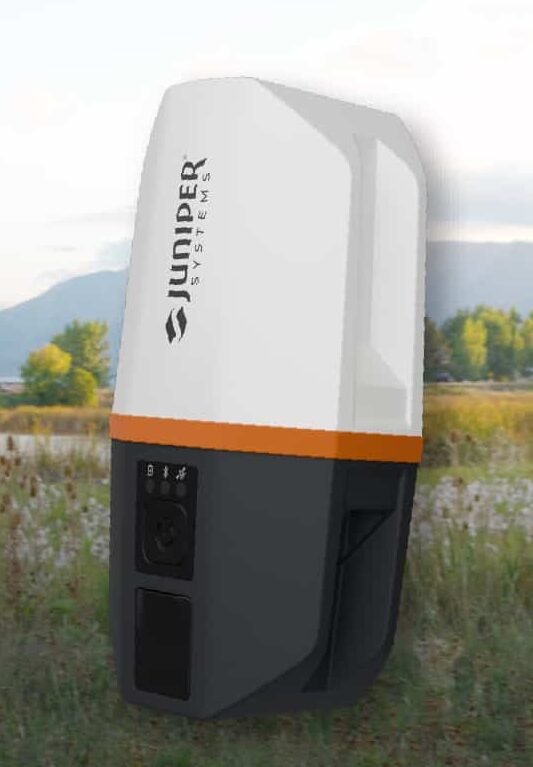
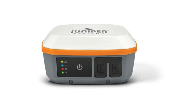
Juniper’s newest GNSS receiver, the Juniper Spire, is designed to simplify location data collection. With the Spire, users can achieve high-accuracy results with a light, compact design, one-button operation, and corrections services right out of the box.
Built for rugged environments and long workdays, it offers seamless integration with mobile devices and data collection apps, making it a reliable companion for all GIS and asset mapping applications.
It is designed for work in both remote areas and urban settings, and supports SBAS, Network RTK, and future correction services. Gather meter to centimeter-level data with our most forgiving antenna. With fast satellite acquisition, multi-constellation tracking, and extended battery life, it delivers consistent performance across a wide range of applications—from environmental monitoring to utility inspections.
Key features include:
Accuracy down to the 2cm range
Worldwide corrections with SBAS, RTK, and future compatibilities
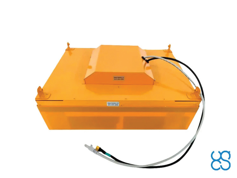
Juniper Systems is partnering with Point One Navigation to enable Juniper’s Geode GNSS receivers to achieve seamless, centimeter-level accuracy through Point One’s Polaris RTK corrections network.
The partnership will deliver integrated, field-ready computing and high-precision positioning solutions for demanding industries across the U.S., Europe and globally. By combining Juniper’s rugged mobile devices with Point One’s professionally managed Polaris RTK corrections network, users will benefit from unparalleled accuracy, increased field uptime, and reliable operation even in harsh conditions, the companies said.
Point One’s Polaris RTK corrections network, with thousands of actively monitored base stations, provides critical positioning in applications such as environmental sciences, utilities, construction and geospatial mapping. When integrated with Juniper Systems’ Geode GNSS receivers, the result is a reliable solution for collecting highly accurate data in remote locations, the companies said.
The partnership is already underway, with collaboration on new product packages, regional support, and joint outreach initiatives planned throughout 2025. Customers will benefit from coordinated service, expert guidance, and access to bundled solutions tailored to their operational needs.
The Archer 4 with GNSS Expansion Pod and RTK connection is now an all-in-one centimeter mapping solution.
Juniper Systems Inc. announces that the GNSS Expansion Pod for the Archer 4 Rugged Handheld is now RTK capable. Juniper Systems is also launching a new application for the Archer 4 called Archer Connect. The Archer 4 with GNSS Expansion Pod and RTK connection is now an all-in-one centimeter mapping solution.
“We are very excited to bring this update to the Archer 4,” said John Florio, senior product manager at Juniper Systems. “The Archer 4 with a GNSS Expansion Pod and an RTK correction is the optimal all-in-one high-precision mapping solution.”
Archer Connect is a utility application that allows users to easily manage their GNSS expansion pod that is attached to their Archer 4. In Archer Connect, users can set up and manage their RTK network connection. Archer Connect is available on the Google Play Store.
The GNSS Expansion Pod attaches and interfaces with the Archer 4 through the Archer’s back contact pads. This allows for a compact one-handed device. The Archer 4 is a rugged handheld device designed to work in extreme environments. Featuring Android 14 and expanded battery options for increased runtimes in the field.
Read a roundup of recent products in the GNSS and inertial positioning industry from the March 2025 issue of GPS World magazine.
Surveying and Mapping
Photo: Eos Positioning Systems
New Eco-Friendly Carrying Case For Eos Positioning Systems’ receivers
The Skadi Gold, Skadi 300 and Skadi 200 GNSS receivers will now be shipped in a field-rugged carrying case made entirely from recycled materials. The case is designed to meet the demands of professionals who utilize GNSS technology in challenging environments. Its construction incorporates durable, eco-friendly materials that can withstand various field conditions, from remote wilderness areas to urban construction sites.
A key feature is its composition of 100% post-consumer recycled resin, which significantly reduces waste and promotes environmental sustainability, according to the company. It is specifically engineered to be shock-resistant and weatherproof.The case is provided as a standard inclusion with every purchase of the Skadi Gold, Skadi 300 or Skadi 200 GNSS receivers at no additional cost.
Multibeam Sonar Designed for bathymetric surveying
The Gemini 1200id is built on the same robust platform as the Gemini 720is multibeam sonar. The device features a 120° horizontal field of view, operating at both 720 kHz and 1,200 kHz acoustic frequencies.
The Gemini 1200id incorporates advanced noise reduction technology to significantly improve the attenuation of waterborne electrical noise to enhance imaging performance. An integrated speed-of-sound sensor ensures high positional accuracy of displayed targets, while CHIRP processing technology enhances target separation over extended ranges.
Compatibility with Tritech’s Genesis software package allows users to control multiple Tritech products from a single interface to streamline operations. The company has also made software development kits available for Windows and Linux operating systems to integrate into various platforms. The sonar’s design includes a custom-developed analog front-end solution with fully differential receiver channels, making it ideal for longer-range applications.
HiPer XRa is a GNSS receiver for surveying, mapping and construction applications. It can benefit a wide variety of users, including construction professionals, surveyors, geographic information systems (GIS) professionals, archeologists, engineering firms and more. The HiPer XR supports GPS, GLONASS, Galileo, BeiDou, IRNSS, QZSS and SBAS.
The new receiver has advanced Topcon Integrated Leveling Technology (TILT) compensation, featuring a calibration-free and magnetic interference-immune integrated IMU that provides up to 60° of tilt for precision measurements in challenging positions. It has signal integrity protection, anti-jamming and anti-spoofing capabilities. Through the myTopcon NOW! website, users can access online training materials, firmware updates and additional software resources.
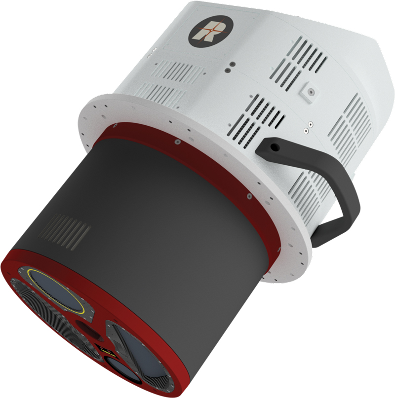
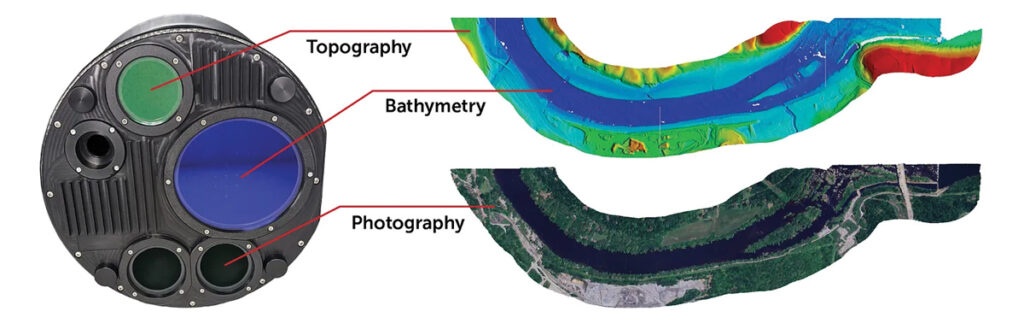
Airborne Lidar System Ideal for coastline and river surveying
CoastalMapper is an airborne bathymetric lidar system for coastline and river surveying. The CoastalMapper can survey coastlines and rivers 250% faster than previous sensor models, according to Leica Geosystems.
It is suitable for various mapping applications, from assessing infrastructure resilience to monitoring river floods and conducting environmental investigations.
It features a high-performance bathymetric lidar module, a Leica TerrainMapper-3 topographic lidar and an imaging sensor, integrated into a compact and lightweight sensor head. This allows the CoastalMapper to capture up to 1 million bathymetric data points and 2 million topographic data points per second while providing high-resolution imagery with a 5-cm ground sampling distance at typical flying heights.
It integrates with Leica Geosystems’ airborne mapping workflows and offers cluster processing capabilities, allowing users to analyze large datasets and reduce the time from data collection to final deliverables. These outputs can include classified point clouds, digital terrain and surface models, and various imaging products.
Surveying Kit Streamlines base station and checkpoint setup
WingtraGROUND, a comprehensive survey kit, streamlines base station and checkpoint setup for on-site post-processing kinematic surveys with the WingtraONE Gen II, a vertical takeoff and landing UAV. The kit combines receivers, checkpoints and tools into a single, portable workflow.
The system integrates hardware components with a Wingtra tablet interface, which can help surveyors confirm correct receiver placement and avoid common errors associated with improper base station setup and inaccurate coordinates.
Wingtra receivers, equipped with Emlid Reach RS3 technology, provide accuracy within 2 cm, meeting high standards for aerial data validation. These receivers can also function independently for terrestrial surveys in real-time kinematic mode, including point collection and stakeout for various applications.
Galileo HAS-Enabled Receiver Offers positioning capabilities with 20 cm accuracy
The Geode GNS3H supports Galileo High Accuracy Service (HAS). It offers positioning capabilities with 20 cm accuracy worldwide without requiring additional infrastructure or subscriptions.
It is built to withstand tough conditions, making it ideal for demanding fieldwork. The device offers various accessories, including the Geode Grip, which combines the Geode with a data collection device of choice into a single handheld solution. A backpack strap kit and survey pole are also available to enhance mobility and flexibility in the field. The GNS3H can be used for surveying, agriculture, construction, forestry, mining and archaeology.
Expanded Mapping Portfolio 3D mapping technologies and more
Topcon Positioning Systems has become an authorized distributor of Pix4D’s photogrammetry software portfolio.
The partnership aims to enhance reality capture solutions across various industries, including surveying, mapping, utilities infrastructure, public safety, forensics, and architecture, engineering and construction.
The agreement streamlines the procurement process for end users by allowing them to access Pix4D’s advanced photogrammetry software solutions through Topcon’s global distribution network.
The GNSS real-time kinematic (RTK) 5 Click — a compact add-on board for high-precision positioning and navigation demands — features the UM980, an all-constellation multifrequency RTK positioning module from Unicore, with the advanced NebulasIV SoC for enhanced performance.
It supports Swift Navigation’s Skylark precise positioning service, multiple GNSS constellations and RTK positioning for centimeter-level accuracy. The board also features JamShield technology for robust performance in challenging environments, USB connectivity for easy configuration and visual status indicators for module status and GNSS signal reception.
It can be used for a variety of applications, including surveying and mapping, precision agriculture, UAVs, autonomous robots and autonomous driving.
Multi-Band GNSS Antenna Can operate in urban environments
Levity Series’ AHP24510 (L1/L2/L-Band) and AHP54510 (L1/L5/L-Band) directional patch antennas are designed to receive signals from GPS, Galileo, GLONASS and BeiDou satellite constellations.
These antennas offer faster and more accurate signal acquisition and lock, specifically in urban environments. The L-Band capability allows compatibility with high-precision GNSS correction services. The multi-band antennas offer integral redundancy to minimize satellite security blind spots and reduce energy consumption due to faster acquisition, requiring less system uptime to save power.
The Levity Series active antennas feature a 45 mm x 45 mm x 10 mm wide-band, dual-stacked patch design with a dual-feed, low noise amplifier, providing 28 dB to 29 dB gain and filtering. They operate with a maximum antenna VSWR of 1-to-1 from 1,207 MHz to 1,603 MHz, and the passive antenna efficiency ranges from 39.93% to 68.51% in the L1 band. These antennas use right-hand circular polarization to mitigate multi-path interference.
The Levity Series includes other multi-band products for high-precision applications, such as the HP24510A and HP54510A stacked-patch passive components, and the TFM.120A surface-mount front-end module, which covers the full multi-band GNSS spectrum including L-band. These antennas are suitable for various applications, including wearables, transportation, robotics, precision agriculture and autonomous vehicles.
The M9PLUS-HCT-A-SMA is an active multi-frequency GNSS antenna designed for high-accuracy applications. It supports L1/L2/L5 GPS, Galileo, Beidou and GLONASS bands, as well as L-band correction services. The antenna utilizes Maxtena’s proprietary Helicore technology, which offers advanced pattern control, polarization purity and efficiency in a compact form factor.
It integrates a pre-filter specifically engineered to mitigate LTE interference. This is crucial for maintaining signal integrity in environments with dense mobile communication networks, where LTE signals can overlap with GNSS frequencies. The pre-filter can effectively block out-of-band LTE signals, reducing intermodulation risks and ensuring clear GNSS signal reception.
The M9PLUS-HCT-A-SMA is built with rugged, IP67 automotive-grade components and includes an integrated SMA connector. It also features an O-ring for enhanced environmental sealing. Weighing only 24 grams, the antenna is ground plane-independent, making it versatile for various installations. It is particularly well-suited for GIS and RTK applications where high accuracy and reliability are crucial.
The MostaTech G321M is a three-axis fiber optic gyroscope (FOG) that offers high-precision navigation and orientation measurement capabilities. This advanced sensor features a data rate of 8 kHz.
Key features of the G321M include an input range of 400° per second, a bias RMS of 1° per hour and an angular random walk of 0.025 °/√h. Additionally, it has a power consumption of 2 W and an initialization time of 1 second. The G321M is designed with a compact form factor, making it suitable for various applications where size and weight are critical factors.
It is ideal for UAVs, robotics, borehole surveys, image stabilization, gimbal stabilization and underwater vehicles.
High-Precision Lidar Designed for precision applications
The TV1 Lite and the TV1 UAV systems are designed for various precision applications, such as mapping and data collection.
The TV1 Lite features TrueNav technology, a Hesai 32-channel laser scanner and a FLIR 5MP global shutter camera with a 90° field of view. It also includes one year of TV1 Lite Annual Processing with support and maintenance.
TV1 offers customization options, allowing users to choose from 26 MP, 45 MP or 61 MP cameras and various Trajectory Correction Service options.
Flight Control System With autopilot functionality
The Prism Supervisor software combines UAV autopilot flight control systems with AI-based observations processed in real time, aiming to enhance UAV operations.
The system provides a programming framework and software development kit for users to create custom mission scenarios. During flight, Prism Supervisor can adapt its autopilot functionality in real time, generating mission segments and flight plans as needed.
The software features a user-friendly graphic interface for mission planning, real-time visualization and execution. It supports Windows, Linux, macOS, iOS and Android.
Remote ID Receiver Enhances airspace awareness and UAV safety
RIDER is designed to enhance situational awareness by providing real-time detection of UAV activity in sensitive areas. It also seeks to provide a clear visibility of surrounding UAV operations to help avoid potential collisions and ensure safer flight experiences.
The device features a built-in industrial chip SIM that provides global coverage through LTE-M and NB-IoT, ensuring connectivity in various environments.
It operates effectively within a temperature range of -20 °C to +60 °C and is rated IP54 for dust and water resistance. The device complies with ASTM F3411-22A and ASD-STAN EN 4709-002 standards, making it suitable for regulatory environments.
The RIDER can detect signals from up to 5 km with its default antennas and up to 10 km when using an optional high-performance antenna. It is equipped with an internal cellular and Bluetooth antenna, along with an integrated GNSS antenna that provides precise positioning and timestamping capabilities. It supports multiple GNSS frequencies and utilizes Bluetooth and Wi-Fi technologies for Remote ID communications.
Streamlined BVLOS Operations For a variety of applications
The Sentaero 6 UAV is designed for advanced over-the-horizon operations beyond visual line of sight (OTH-BVLOS). It features built-in AI and machine learning capabilities for real-time data processing. The system can be used for surveying, mapping, inspection, asset monitoring and more.
Engineered to streamline operations, the Sentaero 6 offers more accurate and up-to-date intelligence on assets. Its onboard computer can processes data mid-flight.
Future developments will include swarm operations, enabling one human to control multiple UAVs simultaneously; fully remote operations and higher safety standards, such as a parachute for urban missions, according to Censys Technologies.
SBG Systems has significantly updated its Ellipse series sensors, incorporating the latest World Magnetic Model (WMM) to enhance accuracy and reliability in navigation applications. This upgrade is available for all Ellipse sensors, including first-generation models.
Designed for unmanned systems such as UAVs, UGVs and marine platforms, the Ellipse series comprises compact, high-precision inertial sensors. These devices feature built-in three-axis magnetometers that measure Earth’s magnetic field, crucial for accurate heading and positioning data.
Updated every five years, the WMM is a globally recognized mathematical representation of Earth’s magnetic field. The latest version, released in December 2024, ensures precise heading and positioning corrections to account for ongoing geomagnetic changes.
NDAA-Compliant UAV Now integrated with ArcGIS Flight
Esri now supports the Astro Max UAV in its ArcGIS Flight application. The Astro Max is the first Blue UAS-cleared and NDAA-compliant UAV to integrate with Esri’s platform.
The Astro Max, developed by Esri partner Freefly Systems, adheres to the security and performance standards set by the National Defense Authorization Act and the Defense Innovation Unit’s Blue UAS initiative. This industrial UAV is designed to enhance the capabilities of government and enterprise users utilizing ArcGIS Flight.
Autonomous Swarm Control Controls various autonomous platforms
The Autonomous Multi-Domain Operations Resiliency Platform for Heterogeneous Unmanned Swarms (AMORPHOUS) software features a single-user interface to operate thousands of autonomous assets simultaneously. Designed with an open architecture, this software enables the U.S. and allied militaries to control a mix of uncrewed platforms, payloads and systems.
AMORPHOUS includes an intuitive and distributed command-and-control interface to give operators the flexibility to conduct a wider array of intricate military missions. This collaborative autonomy at scale will provide warfighters with a decisive overmatch capability.
L3Harris is developing prototypes using the AMORPHOUS architecture on contracts for the U.S. Army and the Defense Innovation Unit. AMORPHOUS has demonstrated flexibility and interoperability by controlling multiple, separate assets across multiple vehicle types operating in different domains during government-managed tests.
AMORPHOUS supports decentralized decision-making, which enables individual, uncrewed assets to perform tasks autonomously and make real-time tactical decisions inside the network.
Advanced Counter-UAV Radar Multi-console radar control and display system
Cambridge Pixel has developed a radar control and display system for Weibel Scientific’s XENTA surveillance radar, which is designed for modern air defense and counter-unmanned aerial systems (C-UAS) applications.
The XENTA radar includes 3D target tracking, continuous target illumination and synthetic receiver beamforming. It is available in two configurations: the XENTA-M for short-range air defense and the XENTA-C for C-UAS operations.
The system is designed to work seamlessly with third-party command-and-control systems, enhancing operational efficiency.
Cambridge Pixel’s library of radar processing software allows users to develop a tailored radar controller specific to the XENTA radar’s requirements. Enhancements were made to existing functionalities, such as improved MIL-STD-2525 overlay graphics and support for dual-redundant operator consoles.
The XENTA radar system can detect small UAVs at distances exceeding 7 km and classify them beyond 5 km. This capability makes it suitable for various applications, including airport security, border control, critical infrastructure protection and event security.
The Pelican 2 agricultural spray UAV has an expanded 300-liter payload capacity and can cover up to 5.3 ha/hr.
It incorporates several technological enhancements designed to meet the demands of agriculture applications. The aircraft features an upgraded four-motor electric propulsion system, a wider 18-m spray swath and advanced lidar and radar systems for fully autonomous day-and-night spraying. These improvements aim to increase efficiency and precision in aerial application while reducing operational costs for farmers.
The Pelican 2’s airframe and structural components are constructed from carbon fiber composites, corrosion-resistant metallic components and 3D-printed assemblies.
A roundup of recent products in the GNSS and inertial positioning industry from the December 2024 issue of GPS World magazine.
Mapping
Photo: SPH Engineering
GPR System For terrestrial and airborne applications
The Zond Aero 500 NG is a versatile ground penetrating radar (GPR) system designed for both terrestrial and drone-mounted surveys, suitable for applications such as utility scanning, sinkhole detection, glaciology and geological studies. It operates in dual mode, allowing for ground-based and airborne surveys, enhancing data collection flexibility. Key specifications include a center frequency of 500 MHz, an operating bandwidth of 200 MHz – 900 MHz, a sampling rate of 25,600 samples per second and a scan rate of 50 scans per second, with depth penetration up to 4 meters in average soil conditions. The system features advanced electronics for real-time data collection, which can significantly improve the signal-to-noise ratio. It is compatible with DJI Matrice 300/350 UAVs for airborne applications.
Streamlined Lidar Mapping YellowScan’s Surveyor Ultra integrated with DeltaQuad Evo
Integrating YellowScan’s Surveyor Ultra with the DeltaQuad Evo platform allows users to collect high-precision, high-density data across 1,200 hectares in a single flight while simultaneously capturing lidar and RGB data.
DeltaQuad Evo’s long-range flight capabilities and efficient vertical take-off and landing (VTOL) design, paired with the Surveyor Ultra’s lidar technology, allow users to streamline their workflows to reduce time spent in the air and on post-processing tasks, making it particularly beneficial for large infrastructure projects, forestry analysis and environmental monitoring. The system can be used for surveying, construction, forestry and environmental research.
Airborne Mapping System With a ‘cross-fire’ scan pattern
The VQ-1560 III-S is a dual-channel laser scanning system designed for airborne mapping applications. Its “cross-fire” scan pattern allows for simultaneous forward and backward viewing at the edges of the swath, along with a nadir view in the center. This configuration optimizes point distribution for effective target sampling. With pulse repetition rates reaching up to 4.4 MHz, the VQ-1560 III-S can operate at altitudes of up to 1,600 m above ground level (AGL). At a lower pulse repetition rate of 560 kHz, it can function at altitudes as high as 3,900 m AGL.
The system features inertial measurement unit (IMU) and GNSS integration, with the option to include one or two high-resolution RGB/NIR cameras. It is ideal for professionals in fields such as urban planning, forestry and environmental monitoring.
This bathymetric lidar system is designed for coastal and inland water mapping. It combines high-resolution topographic and bathymetric capabilities, allowing for seamless data collection across land and sea. It can be used for coastal zone management, environmental monitoring, infrastructure planning and more.
Fathom delivers data quickly by leveraging real-time quality control with Onboard and scalable processing with a CARIS workflow. It also includes a built-in topographic lidar and a multispectral camera for coastal surveys at a coverage of 50 km2/hour.
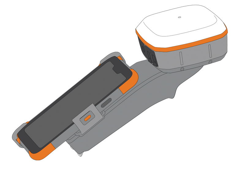
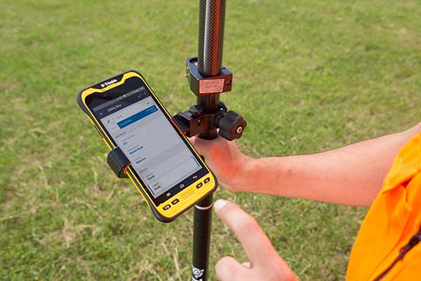
The Geode Grip is a mounting accessory featuring a specialized bracket. It allows users to securely attach smartphones directly to Juniper’s Geode GNSS receivers, offering an integrated and streamlined data collection solution.
The Geode Grip is a tool designed for professionals in surveying, mapping and geographic information systems (GIS) to enhance mobile data collection. It replaces the traditional survey pole with a handheld setup that aims to improve ergonomics. It is ideal for field projects that require precise location data and mobile data collection, such as environmental research, land surveying, agriculture and infrastructure engineering.
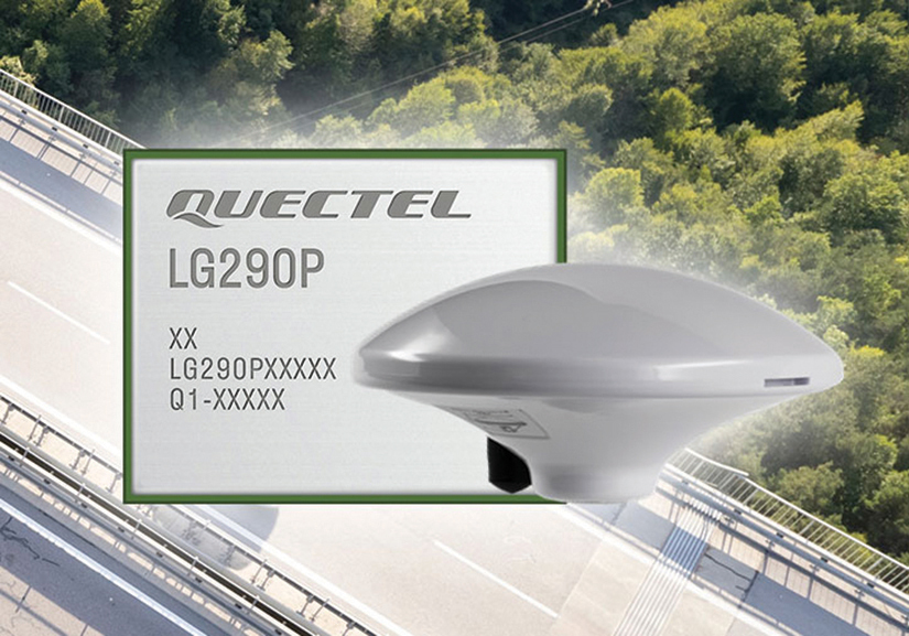
New Product Bundle For high-accuracy GNSS applications
Quectel Wireless Solutions has unveiled a new product bundle designed to facilitate the development of high-accuracy GNSS applications. The bundle includes the LG290P GNSS module, which is a quad-band, multi-constellation device capable of receiving signals from various satellite systems, including GPS, GLONASS, Galileo, BDS, QZSS and NavIC. The LG290P is engineered for high precision and supports RTK positioning, allowing for centimeter-level accuracy even in challenging environments. It can be used in diverse applications, such as autonomous vehicles, precision agriculture and surveying.
In addition to the LG290P module, the bundle includes options for either the YEGN103W8A geodetic antenna or the YEGD006U1A patch antenna. Both antennas are designed to operate within the same frequency bands as the GNSS module and are compliant with environmental regulations such as RoHS. This pre-integrated solution simplifies developers’ procurement and integration process by providing a one-stop solution that combines antennas with GNSS modules and RTK correction services.
Lidar Camera Payload For surveying and mapping applications
The RESEPI Ultra LITE is a lightweight payload combining lidar and camera technology for advanced surveying and mapping applications. The system integrates the XT-32 lidar scanner to offer users advanced data accuracy and point density across various operational modes.
It has a compact design with a 5MP colorization camera, making it ideal for small unmanned aerial systems (SUAS) with strict volume constraints. It can be used for aerial and ground-based applications, including utility mapping, construction volumetrics, precision agriculture, forestry, site surveying and mining. Designed for seamless integration, the system is compatible with a wide range of platforms such as Freefly, WISPR, DJI, Sony and mobile setups. Inertial Labs’ proprietary SnapFit adapters ensure quick and secure mounting to enhance the system’s adaptability.
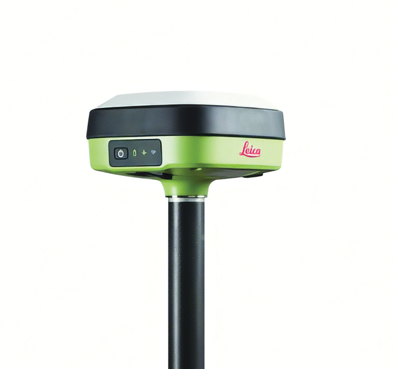
The Leica GS05 is a compact and lightweight GNSS smart antenna designed for surveying tasks, featuring calibration-free tilt compensation. This robust device allows for accurate measurements even when the survey pole is tilted up to 30°, enhancing data collection in challenging environments. Its integration with Leica Geosystems’ portfolio, including Leica Captivate software and total stations, seeks to maximize efficiency. The GS05 can function as both a base and an RTK rover, supporting single base stations and RTK networks such as Leica SmartNet.
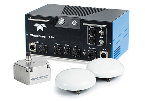
Intrepid is a GNSS/INS system integrated with the SeaBat T20-ASV processor and includes a compact IMU and two GNSS antennas, ensuring reliable and precise positioning.
It can automatically stream data to third-party software. This eliminates the need for manual sensor interfacing and reduces downtime. The Intrepid GNSS/INS benefits users in marine surveying applications by providing the precise navigation necessary for operational efficiency. Its intuitive design allows for simple configuration.
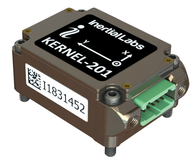
Miniature MEMS Sensor-Based IMU Can withstand high shock and vibrations
The KERNEL-201 features three-axis MEMS accelerometers and gyroscopes that offer ultra-low noise, high bandwidth and minimal latency. These characteristics make it ideal for applications such as pointing, stabilization and navigation in systems where performance and size are critical. Its volume of 0.38 cubic inches offers a high dynamic range.
Fully calibrated and temperature-compensated, the unit offers consistent, precise measurements even in challenging environments. It features an in-run bias stability of up to 0.7 deg/hr for gyroscopes and 0.005 mg for accelerometers, along with a low angular random walk (ARW) of 0.065°/√hr and velocity random walk (VRW) of 0.015 m/sec/√hr.
The unit is designed to withstand high shock and vibration while maintaining peak performance, making it suitable for a wide range of challenging applications. The KERNEL-201 can be integrated into various high-level systems, such as motion reference units (MRUs), GPS-aided inertial navigation systems (INS) and attitude and heading reference systems (AHRS). It offers continuous built-in testing (BIT), customizable communication protocols and flexible power options.
Smart Choke Antenna Offers comprehensive GNSS signal reception
The VCS6000XF full band smart choke antenna is engineered for CORS applications. It combines Tallysman Verachoke antenna elements with Septentrio’s Mosaic X5 full-band receiver to offer an integrated solution for OEM CORS systems.
The VCS6000XF offers comprehensive GNSS signal reception, including GPS/QZSS L1/L2/L5, GLONASS G1/G2/G3, Galileo E1/E5a/E5b/E6/E5 AltBoc, BeiDou B1/B2/B2a/B3, NavIC L5, SBAS and L-Band correction services.
The antenna features a 0.5 mm phase center variation and utilizes Calian’s eXtended filtering for near-band signal interference mitigation. The integrated Septentrio Mosaic X5 receiver provides capabilities such as anti-jamming, anti-spoofing, scintillation mitigation and receiver integrity by combining the antenna and receiver in the choke ring antenna.
A roundup of recent products in the GNSS and inertial positioning industry from the February 2024 issue of GPS World magazine.
SURVEYING & MAPPING
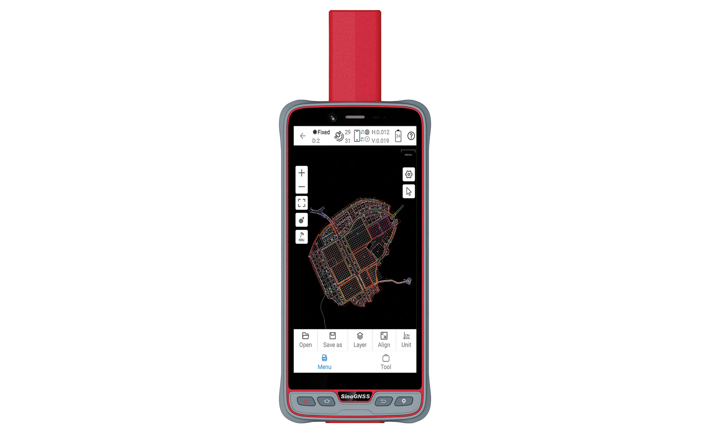
Handheld GIS Data Collection Solution For outdoor operations
The handheld P6H solution is designed for GIS data collection and outdoor operations. Featuring a GNSS high-precision positioning module, rugged IP67-rated design, and 6-inch sunlight-readable display, the P6H offers positioning accuracy in harsh environments.
Equipped with a SinoGNSS self-developed high-precision K8 board and antenna, it can track all running and planned constellations with 1,590 channels, including GPS, BeiDou, GLONASS, Galileo, QZAA, IRNSS, and SBAS.
The P6H offers users centimeter- or decimeter-level accuracy. Its IP67 rating protects against dust and water to enhance its efficiency and durability in tough environments.
The device comes equipped with Survey Master and robust GIS functions, which allow users to take measurements of geographic elements and store the results as attribute data for subsequent analysis, calculation, and visualization. It also includes a mock location function for users to accurately share Survey Master’s position with P6H. The location data can then be accessed on a third-party GIS software.
It is also compatible with common GIS software such as ArcGIS Collector, Mapit GIS, and QGIS. Additionally, the P6H features an 8-core 2.0 GHz processor, up to 128 GB of storage and up to 6 GB of RAM to offer users smooth software operation and efficient data processing.
PH6, which features a high-precision GNSS module and antenna, also incorporates 4G LTE, Wi-Fi, and Bluetooth to improve its data transmission and sharing capabilities.
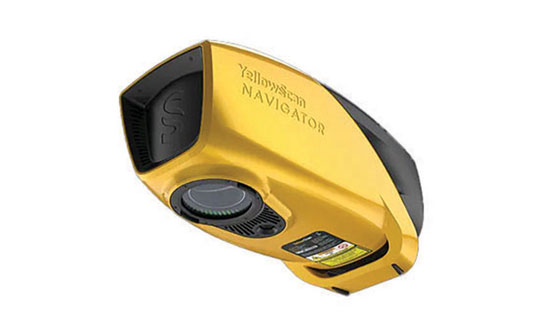
Bathymetric Lidar System Maps underwater topography
YellowScan Navigator is a bathymetric lidar system designed for surveyors to map underwater topography in rivers, ponds, and coastal areas.
The system features a laser scanner developed in-house over the course of five years and has been heavily tested to achieve optimal performance. The compact system can map waterbeds with a depth of up to 3 m and can reach a depth of 18 m in perfectly clear water conditions, according to the company. It can be flown up to 100 m above the water surface and provides measurements with an accuracy of 3 cm. Additionally, a camera is embedded for true-color data visualization.
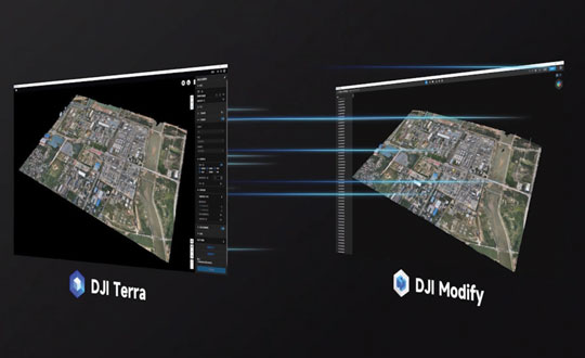
3D Model Editing Software For aerial surveying, transportation, and emergency responses
DJI Modify is an intelligent 3D model editing software. It can be seamlessly integrated with DJI’s enterprise UAVs and 3D modeling and mapping software, DJI Terra. When integrated with these products, the software can be used for aerial surveying, transportation, and emergency responses.
DJI Modify paired with DJI Terra offers users an end-to-end solution from modeling to model editing. Once DJI Modify has been enabled, DJI Terra files for model editing are automatically generated, including pre-identified objects and pre-processing of the model. It is designed to make repairing common 3D model defects seamless and efficient. As of early 2024, DJI Modify will only support repairing models built by DJI Terra.
DJI Modify allows for model files to be quickly imported and exported to the DJI Terra and other third-party software. Its intelligent auto-repair editing supports flattening, editing textures, repairing water surfaces, removing floating parts, and filling holes. Edits can be made using one-click repairs or manually by selecting custom polygons, areas or meshes.
The software’s smoother model display technology allows high- and low-quality models to be viewed and edited in a single interface. Changes made can be synchronized across both models and previewed immediately, which allows users to address model editing issues in real-time.
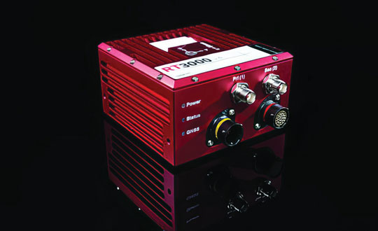
GNSS/IMU Uninterrupted position, orientation, and dynamics
RT3000 v4 GNSS inertial measurement unit (IMU) combines two survey-grade GNSS receivers with OxTS’ IMU10 inertial technology. The RT3000 v4 offers uninterrupted position, orientation and dynamics in challenging environments.
The IMU will reach the desired specification within three minutes of low dynamic movements, which reduces the time and space required for high dynamic maneuvers before each data collection.
Users can customize the INS with optional features and software integrations to create the ideal INS for individualized projects, including lidar surveying and mapping or positioning in GNSS-denied or challenged environments.
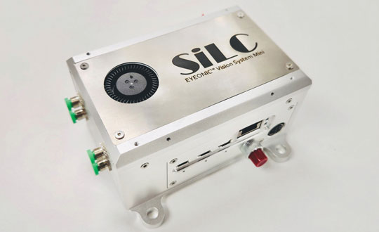
Precision Lidar Technology Provides vision capabilities in challenging environments
The Eyeonic Vision System Mini (Eyeonic Mini) supports sub-millimeter resolution in a reduced size. The system integrates a full multi-channel FMCW lidar on a single silicone photonic chip and an integrated FMCW lidar system-on-chip (SoC).
The Eyeonic Vision Chip combines crucial photonics functions into a coherent vision sensor. The system’s accuracy stems from a 4-channel FMCW LiDAR chip — supported by Indie Semiconductor Surya SoC technology — to provide robots with sub-millimeter depth precision from distances exceeding 10 m.
The technology offers enhanced precision and can be used in automation, including warehouse logistics and artificial intelligence (AI) machine vision applications. Palletizing robots equipped with the Eyeonic Mini can view and interact with pallets, which aims to optimize package placement and truck loading with greater efficiency and safety.
The Endura Epoch Platform provides robust and resilient positioning, navigation, and timing (PNT) services critical in defense operations.
The MEMS oven-controlled oscillator (OCXO) can boost the resilience of PNT systems and other equipment, including radars, field and airborne radios, satcom terminals, and avionics against spoofing, jamming and other disruptions in GPS signals.
Based on the Epoch Platform, the Endura Epoch MEMS OCXOs are designed to meet the challenging shock and vibration conditions found in aerospace and defense. These devices are manufactured using semiconductor processes that deliver the reliability and quality expected from silicon devices. The same level of reliability cannot be achieved by quartz crystal OCXOs, specifically in extreme conditions.
The Endura Epoch MEMS OCXOs, compared to quartz crystal OCXOs, includes various features and benefits, including programmable frequencies from 10 to 220 MHz; a 20,000 g shock survivability rating; up to 20 times better frequency stability over temperature; up to three times better Allan deviation, a measure of short-term frequency stability; surface-mountable, small footprint and low height 9.0 x 7.0 x 3.6 mm; low weight of 0.35 g; 420 mW steady state power.
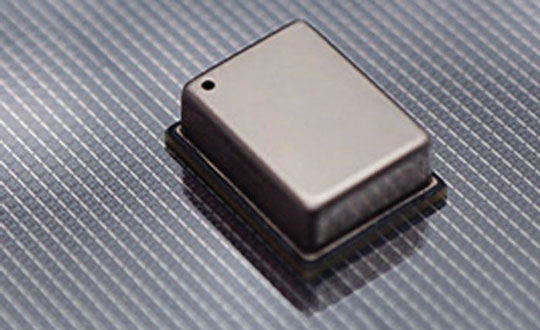
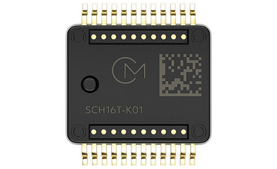
The SCH16T-K01 is an inertial measurement unit (IMU) featuring a XYZ-axis gyroscope and a XYZ-axis accelerometer, for a total of six degrees of freedom.
The SCH16T-K01 includes a sophisticated gyro with typical bias instability of 0.5 dph and up to 0.3 mdps/√Hz noise density. The accelerometer has a dynamic range of up to 26 g, which provides resistance against saturation and vibration.
The component’s output is internally cross-axis compensated, which eliminates the need for extensive calibration. Through the integration of these features, the SCH16T-K01 can deliver accurate measurements in machine control and guidance without field calibrations.
It is suited for industrial applications such as construction and agricultural machines, material handling equipment, marine instrumentation, robotics, and UAVs.
3-Axis Optical Gyroscope IMU For GPS-denied environments
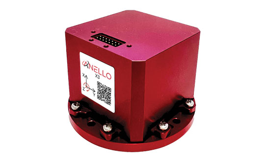
The ANELLO X3, a 3-axis optical gyroscope inertial measurement unit (IMU), is designed for GPS-denied and challenging environments.
The IMU leverages ANELLO SiPhOG (Silicon Photonics Optical Gyroscope) technology and serves as a light, low-power tri-axial optical gyroscope offering high accuracy, performance, and reliability for autonomous applications.
The ANELLO X3 can be used in a variety of applications, including autonomous commercial and defense applications involving robots, UAVs, electric vertical take-off and landing (eVTOL) aircraft and various maritime and land vehicle applications, including high-accuracy surveying and mapping.
The AntaRx smart antenna is designed for machine automation and control in construction, precision agriculture, and logistics. It is enclosed in a rugged and compact housing for simplified installation and can handle high levels of shocks and vibrations, making it ideal for harsh industrial environments such as construction and mining.
The multi-frequency receiver offers centimeter-level real-time kinematic (RTK) positioning and can be used in inertial navigation system (INS) integration, dual antenna mode, and 4G cellular communication. It is available in several configurations, including as a GNSS smart antenna or a GNSS/INS smart antenna system and can be integrated as an inertial measurement unit (IMU).
The receiver technology integrates the company’s GNSS+ algorithms, including advanced multipath mitigation, which offers uninterrupted operation in challenging conditions such as near high structures or machinery.
The Lixel X1 is a powerful 3D scanner that combines lidar, visible-light and motion cameras, and high-precision inertial sensing using SatLab’s simultaneous localization and mapping (SLAM) technology.
Data and scene reconstruction can be previewed in real time and can be exported immediately after scanning without the need for post-processing, which aims to simplify workflows and enhance efficiency.
The system enables scans to be resumed from breakpoints, which allows surveys to be broken up into convenient segments. It provides up to 60 minutes of continuous operation and can be easily mounted to UAVs and other mobile mapping platforms.
Ceramic Antenna For connectivity on L1 GNSS signals
Admotus is a surface-mount ceramic antenna designed for connectivity on L1 GNSS signals on all constellations, including GPS-L1 at 1575.42 MHz; GLONASS L1, 1602MHz; Galileo L1, 1575.42 MHz; BeiDou (B1); and QZSS. It offers comparable performance to a small patch antenna on a small ground plane.
The ceramic antenna has an ultra-low profile measuring a mere 1.0 x 0.5 x 0.5 mm, requires 7 x 15 mm clearance area and offers improved performance on small PCB sizes.
Admotus offers a peak gain of 0.9 dBi with an average gain of –2.6 dB and offers maximum return loss of –11.5 dB and a maximum VSWR of 1.8:1. A companion evaluation PCB is also available for internal analysis.
It is suitable for all GNSS positioning applications in the L1 band (1559 – 1609 MHz) such as wearable devices for fitness and medical monitoring, small portable tracking devices used to track keys, pets, bikes, UAVs, agricultural robotics, and telematics devices.
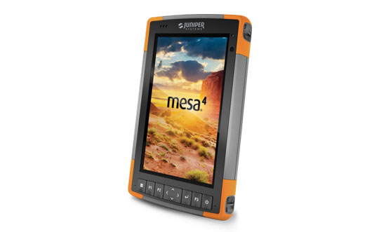
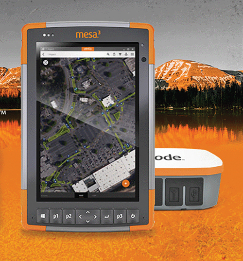
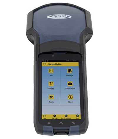
The Mesa 4 Rugged Tablet features a 7-inch display and runs on Windows 11. It is designed to provide powerful rugged computing and data collection to mobile field workers.
The Mesa 4 comes with a new Intel N200 processor. It offers up to three times the CPU performance of the Mesa 3 and has an increased RAM size and speed to enhance its processing power. Mesa 4 has an IP68 rating, MIL-STD-810H certification and ergonomic design for all-day carrying.
UAV Ground Control System On an 8-inch rugged tablet
The Ground Control System (GCS) for UAVs is centered around RuggON’s LUNA 3 8-inch rugged tablet. It is designed to provide real-time control, telemetry, and satellite positioning for connected UAVs.
GCS is designed to provide users more control over a variety of UAVs by using the LUNA 3 rugged tablet, which has a large and high-definition screen to provide video feedback during operations. The system is also certified to provide GNSS positioning and tracking services.
Featuring a low-latency video software decoder, GCS allows for real-time high-resolution video viewing and data collection. Engineered to withstand dust, shock, and water, the control system can withstand challenging environments.
The LUNA 3 8-inch rugged tablet stands as a powerful and efficient model within its class, powered by an Intel Core i5 processor (1145G7E) with Intel Iris Xe graphics and the Windows operating system. Its sunlight-readable display supports night and stealth modes, which is cruicial for law enforcement and military applications. The tablet offers touchscreen functionality for enhanced operator convenience, complemented by ethernet and optional Wi-Fi 6, and 4G LTE connectivity.
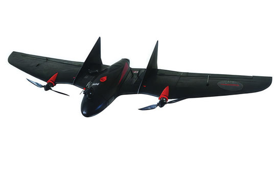
The VT-Naut, vertical takeoff and short landing (VTOSL) is a versatile aerial solution designed for a variety of applications, including high-precision mapping and surveying for inspection, scouting, observation, and agriculture.
The VT-Naut can land on water, which makes it ideal for shipboard or coastal operations, and opens new ways for users to collect and observe data. It has a long-range telemetry link of 30 km and a flight endurance of up to 90 minutes. Its compact and robust body design provides durability and resilience in harsh environments.
The VT-Naut UAV system offers a cost-effective alternative to full VTOL platforms, particularly for users who require extensive surveying capabilities and have some flexibility in landing site selection. The system eliminates the extra costs associated with acquiring and operating a VTOL multirotor drone.
The AIDrone UAV is designed for a variety of applications, from infrastructure inspections and renewables to defense and public safety.
The UAV features a high-performance payload, fitted with a 64MP EO/IR camera mounted on a dual-axis gimbal that can support vertical rotation of up to 200°. AIDrone can spot millimeter-sized cracks and detect subtle temperature changes in challenging environments.
AIDrone uses Nearthlab’s vision-based autonomous flight technology to operate autonomously — in zero-light and GPS-denied environments — both indoors and outdoors.
It weighs around 4 lbs and has a foldable structure. AIDrone is designed for intelligence, surveillance, and reconnaissance (ISR) purposes, which makes it ideal for crisis management scenarios such as wildfire response and law enforcement.
The Ghost Dragon intelligence, surveillance, and reconnaissance (ISR) UAV offers higher resistance against jamming and spoofing. The UAV is equipped with a thermal and visual light camera and jamming-resistant radio. Its wide frequency hopping radio is used to provide a jamming-resistant video and telemetry link, which makes it difficult to detect the UAV and interfere with the mission.
The Ghost Dragon ISR uses a dual-band GNSS module that operates on both L1 and L5 bands, which allows for flight operations even in challenging environments. The UAV can operate in radio silence mode in the presence of GNSS and store reconnaissance data on an encrypted SD card to view after the UAV has landed. The video and target location information streamed to the operator is also georeferenced.
The UAV can be redirected, flown back to base, or handed to another operator at a different ground control station at any time.
The new device will ship in the fourth quarter of this year and is available for pre-order
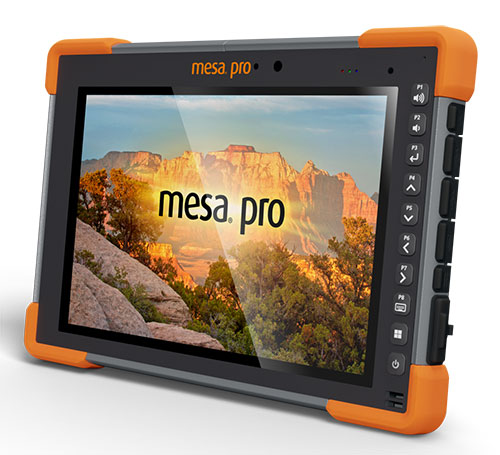
Juniper Systems is entering the 10-inch rugged tablet market with the launch of its Mesa Pro rugged tablet. The Mesa Pro features 11th Generation Intel Core processors, a Windows 11 operating system, device customization options, a large sunlight-readable display and “Juniper Rugged” company design.
“We are excited to be entering the 10-inch rugged tablet segment for the first time,” said Darren Hellstern, the Mesa Pro product manager at Juniper Systems. “Mesa Pro offers powerful processing, a rugged design meant for any environment, and is a versatile workstation that can be used in the office or the field.”
Standard Mesa Pro units come equipped with an 11th Gen Intel Core i5 processor and 16 GB of LPDDR4x RAM. Core i7 and Celeron versions of the device are also available.
Each Mesa Pro configuration offers powerful performance and allows users to select a level of computing performance that best fits their needs while having options that meet their budgets.
“It was important for us to offer performance tiers,” said Hellstern. “This is the first time we have offered various performance levels in one of our devices. The needs that our customers and users have varies greatly. From running CAD programs, viewing construction plans, mapping and mounted-vehicle solutions, we feel that we have an offering with Mesa Pro that fits the processing need of the user. We are also available to help users determine what level of performance they need.”
Mesa Pro joins the current Mesa family of 7-inch devices and helps Juniper Systems achieve its mission of providing powerful rugged computing and data-collection devices to mobile field workers everywhere. The Mesa 3 runs on either Windows or Android operating systems. The Mesa family started in 2010 with the launch of the Mesa Rugged Notepad.
“Mesa devices have served our customers for over a decade,” said Hellstern. “We are proud to add Mesa Pro to that list of incredible devices and offer more options to our customers and users around the world.”
Juniper Systems is now accepting pre-orders for the Mesa Pro.
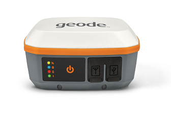
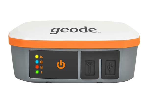
Juniper Systems has introduced the Geode GNS3 GNSS receiver, which allows users to collect real-time GNSS data with sub-meter, sub-foot and decimeter accuracy options.
With a scalable platform, users can purchase the level of accuracy they need now, while having the option to increase accuracy in the future.
“This new Geode offers expanded accuracy options to our users,” said John Florio, Geode product manager at Juniper Systems. “We set out to deliver a product that is scalable to our user’s needs. The GNS3 allows users to purchase a receiver that fits their accuracy needs at the moment, while still being able to unlock greater accuracy through subscriptions when that need arises.”
Photo: Juniper Systems
Available in both single-frequency and upgradable multi-frequency antenna configurations, users have the level of accuracy needed to get the job done. The Geode GNS3S offers superb sub-meter accuracy with a single-frequency antenna. The GNS3M allows for scalable accuracy; its multi-frequency antenna support all constellations on L1, L2 and L5 frequencies.
Multi-frequency signal tracking, together with Atlas L-band correction subscriptions, allow for up to decimeter accuracy. As with previous Geode devices, SBAS corrections are available for sub-meter accuracy in certain regions.
Both models also support local differential GNSS real-time kinematic (RTK) and continuously operating reference networks (CORS) through the Geode Connect NTRIP client.
“Providing Atlas corrections and scalable accuracy allows for the Geode to be used in new markets,” Florio said. “A few of these include water utility locating, agriculture and irrigation mapping, mapping projects in remote locations where other correction services are not available, and any other mapping need that requires a higher degree of accuracy.”
The Geode GNS3 offers flexible connectivity and can be used with Windows, Android, iPhone and iPad devices. A USB-C port allows for data transfer and fast charging and an antenna port allows for the use of an external antenna.
The Geode GNS3 GNSS receiver is now available worldwide.
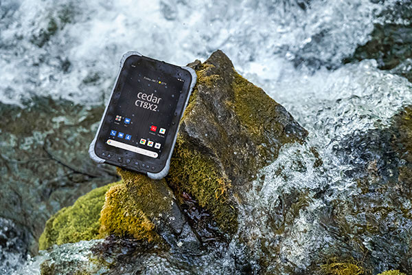
Juniper Systems is has launched its latest rugged tablet, the Cedar CT8X2. The new tablet offers increased processing power, RAM and storage, running on the Android 10 operating system. Despite these features, the CT8X2 retains the same powerful GNSS functionality of the previous Cedar generation for the same price.
“The CT8X2 is our best Cedar tablet to date,” said Cody Draper, Cedar product manager. “It exceeds expectations in terms of price, performance and versatility. It is a perfect device for those looking for a mobile data-collection device that offers a much greater degree of ruggedness than a consumer product.”
Powered by an octa-core Snapdragon CPU from Qualcomm, the CT8X2 allows for larger files compared to the previous Cedar. Greater onboard storage prevents users from needing to offload data frequently and provides sufficient space for applications. With GNSS accuracy of about one meter in open skies and five meters under tree canopy, the CT8X2 offers capable GNSS positioning that far exceeds the accuracy of typical consumer devices. The CT8X2 also has a high-resolution screen.
“The performance increase of the CT8X2 gives users a very capable device in the field,” Draper said. “We were able to provide these advancements in performance and GNSS accuracy while maintaining our affordable price point.”
A roundup of recent products in the GNSS and inertial positioning industry from the February 2021 issue of GPS World magazine.
OEM
Development kit
Allows engineers to evaluate GNSS/INS module
Photo: Aceinna
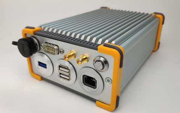
The Aceinna OpenRTK330LI EVK is a complete evaluation and development kit for the OpenRTK330LI GNSS/INS module. The kit accelerates development and reduces time to market of custom navigation and guidance systems fusing inertial measurements and multi-band RTK/GNSS positioning. It provides the essential hardware, firmware and development environment that engineers working on autonomous applications need to quickly start developing algorithms and solutions, allowing engineers to log and visualize positioning data with centimeter precision.
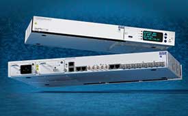
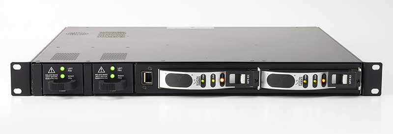
The OSA 5412 and 5422 are edge and access network synchronization devices with enhanced capabilities for next-generation applications such as 5G. The Oscilloquartz solutions address key challenges for a wide range of industries by bringing new levels of timing accuracy and resilience to edge networks. Both models provide in-service sync probing and assurance as well as innovative GNSS assurance capabilities. The devices also eight field-upgradeable, 10-gigabits-per-second ports, ensuring the scale and efficiency needed for next-generation smart grids, industrial internet of things (IoT) applications and 5G connectivity.
The AirgainConnect AC-HPUE 6-in-1 is a rugged outdoor mobile antenna with integrated modem, designed to meet the most demanding LTE connectivity needs of public safety and fleet vehicles. AC-HPUE provides two or three high-gain multi-band LTE antennas and one-band 14 LTE antenna powered by an HPUE LTE modem. The AC-HPUE supports an active GNSS element as well as two or three high-gain tri-band Wi-Fi antennas, including the new 6 GHz ISM band for Wi-Fi 6E (802.11ax), inside a single robust and compact housing. AC-HPUE attaches to the router WAN port via Ethernet data cable or directly to a laptop via USB cable. Wi-Fi and GNSS antennas connect to the router, meaning the router can be seamlessly used for Wi-Fi, location-based services, and managed using existing network management systems.
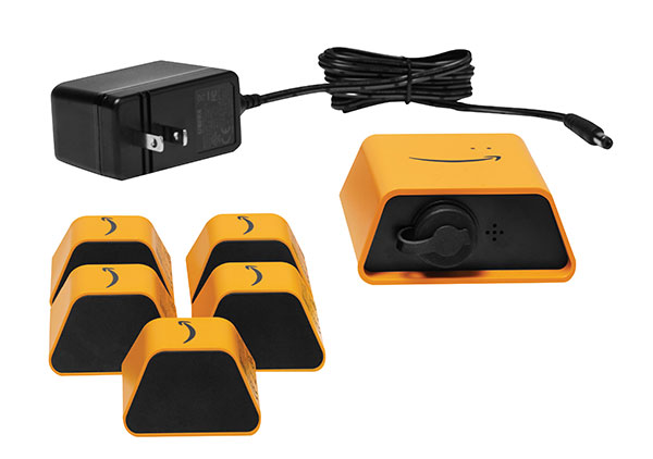
Amazon Monitron provides customers with an end-to-end machine monitoring solution comprised of sensors, gateway and machine learning service to detect abnormal equipment conditions that may require maintenance. Monitron is one of five new machine learning services that help industrial and manufacturing customers embed intelligence in their production processes to improve operational efficiency, quality control, security and workplace safety. The services combine sophisticated machine learning, sensor analysis and computer vision capabilities to address technical challenges faced by industrial customers. The other four services are Amazon Lookout for Equipment, the AWS Panorama Appliance, the AWS Panorama SDK and Amazon Lookout for Vision.
Carlson Layout allows fast, efficient layout capabilities for construction professionals using total stations or GPS receivers such as the Carlson CR+ series of robotic total stations and the Carlson BRx7 GNSS receiver. Included are the full Carlson driver library and a range of compatible hardware options. Features include an intuitive user experience, support for DXF and DWG files, integration with Google Drive and other cloud storage, compatibility with Carlson CRD and CRDB files, and the ability to check surface or fixed elevations without creating points. It also includes simple layout for points, lines and surfaces. Layout works with GPS real-time kinematic (RTK) systems and can receive RTK connections from a cellphone, internal modem, internal radio or external radio.
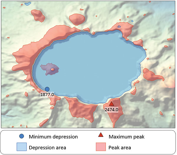
Surfer is a gridding, contouring and 3D surface-mapping package. The latest version offers a greater number of options for displaying scientific data. New display options enable users to more easily communicate the information extracted from their data. The Surfer package is used by professionals in oil and gas exploration, environmental consulting, mining, engineering and geospatial projects to easily visualize and interpret complex data sets. Surfer enables users to model data sets, apply an array of advanced analytics tools, and graphically communicate the results. Features include a new peaks and depressions layer type for mapping geohazards or drainage patterns in karst topographies.
Uinta’s data collection tools include detailed mapping with points, lines, areas and form-based notes for digital recordkeeping. Customization options allow organizations to create templates that better align with the type of data they are mapping and recording. Templates can be shared among users, and Juniper Systems has many templates for various industries and use cases. Users can export data to a file, print professional PDF map reports, and create optional cloud projects. Combined with a Mesa 3 Rugged Tablet running Windows 10 and a Geode Sub-meter GPS Receiver, Uinta offers a rugged, robust and powerful data collection solution. Industries using Uinta include utility mapping, government asset management and mapping, industrial assets, irrigation, and sectors within natural resources.
The FLY-R R2-150 has a top speed of 200 km/h (124 mph). Currently in functioning prototype form, the battery-powered R2-150 is designed for such tasks as fully autonomous surveillance, observation and reconnaissance. It has a wingspan of 1.5 meters (4.9 feet), a cruising speed of 115 km/h (71 mph), and can fly for up to two hours per charge while transmitting real-time video. It can automatically take off from a ship- or truck-mounted vacuum launcher and land in a recovery net. Another model, the jet-powered R2-HSTD, is expected to have a top speed of Mach 0.65 (803 km/h or 499 mph) and is intended to serve as a target drone for military exercises. FLY-R’s aircraft incorporate a rhomboidal wing design, which reduces wingspan by half and reduces aerodynamic drag.
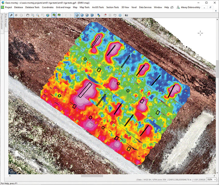
The drone-integrated metal detection system uses an airborne modification of the Geonics EM61-MK2 ground metal detector. The EM61 Lite airborne variant integrates with the UgCS SkyHub onboard computer and ground control station. Features include automatic data logging in geotagged form and automatic terrain following with radar altimeter. The use of UgCS SkyHub enables the drone to fly in true terrain following mode with the help of the radar altimeter and to log geotagged sensor data. An optional RTK/PPK GNSS receiver on the drone will geotag the data with centimeter-level precision. The integrated system has been extensively tested at SPH Engineering’s test range, and has shown excellent performance and repeatability for targets such as pipes (steel, stainless steel, reinforced concrete) and steel drums. Applications include unexploded ordnance (UXO) search, detection of underground infrastructure and archaeology.
A roundup of recent products in the GNSS and inertial positioning industry from the October 2019 issue of GPS World magazine.
OEM
Multi-GNSS receiver
Refined in the Galileo Online project for rail applications
Photo: TeleOrbit
The multi-GNSS receiver GOOSE, distributed by TeleOrbit GmbH and developed by Fraunhofer IIS, is now available in a new housing. GOOSE now also includes the new OS-NMA beta standard, available by the end of 2019, which was integrated within the research project PRoPART. GOOSE is a flexible, professional GNSS receiver development platform with an open software interface, which can be adapted to a variety of applications and application-specific correction services. The flexible development platform offers multi-system and multi-signal real-time processing; integrated antenna receiver combination (smart antenna); guaranteed stable phase center for all GNSS frequencies; and deployment in commercial PC or as an embedded platform. It allows deep coupling and vector tracking in real time; access to correlation values; and record and replay of IF samples. It also offers access to SBAS data including upcoming augmentation systems and differential augmentation systems. The platform has been refined in the Galileo Online project for specific usage in rail applications. It has also been further upgraded as a robust and reliable Galileo position sensor for autonomous truck applications.
Low-noise performance for high dynamic applications
Photo: Gladiator Technologies
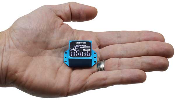
The LandMark 007 inertial measurement unit (IMU) combines low noise, high range sensors and Velox high-speed output in a rugged package measuring 0.7 inches square. With rate ranges up to 2000°/s and acceleration ranges as high as 200 g, the LandMark 007 IMU provides demanding, precision performance for a range of high dynamic, rugged applications. High-speed output data rates (up to 10 kHz) for measurement accuracy and flexibility are complemented by low-noise gyros and accelerometers. A development kit is available.
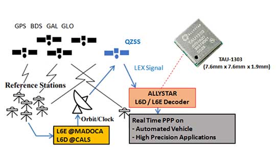
The QZSS L6 decoder module TAU-1303 supports tracking QZSS signals L6D (CLAS) and L6E (MADOCA). It can decode corrections data broadcast from L6D and L6E signals, and assist developers in applying the centimeter-level accuracy by PPP-RTK algorithm with the correction data. Within its 7.6 × 7.6-millimeter size, the module provides six channels to support tracking L6D and L6E at the same time. CLAS on L6D channel corrects satellite clock, orbit, code bias, phase bias ionosphere delay and tropospheric delay. MADOCA on L6E channel corrects satellite clock, orbit, code bias and phase bias. The TAU-1303 offers superior performance through an on-board 26-MHz temperature-compensated crystal oscillator (TCXO) and a reduced time to first fix because of its dedicated 32-KHz real-time clock oscillator. Based on 40-nanometer manufacturing processes of the Cynosure III GNSS chipset, the TAU-1303 has very low power consumption of less than 40 mA at 3.3V.
ViaLite’s new Local Integrated GPS Splitter was designed to minimize rack space. The unit provides a fan-out of GPS/GNSS signals within a local area, can accept optical inputs from up to four antennas, and has a 1000-1800-MHz frequency range. Though it has a height of only one rack unit, the system is useful for feeding timing and synchronization signals to single or multiple floors or rooms through eight to 32 optical fiber links with no system loss. It includes built-in simple network management protocol (SNMP) control as well as dual-redundant power supply units. Built for data centers, banking institutions, scientific research establishments, cellular test environments, fixed satcom stations, oil and gas platforms, and big data.
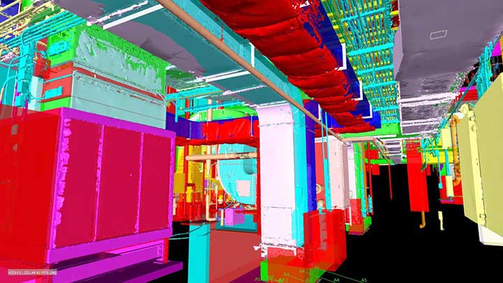
Pointfuse point-cloud processing software converts the millions of individual measurements captured by laser scanning and photogrammetry into 3D mesh models.The latest release features streamlined classification to ensure maximum efficiency and multicore processing for unlimited conversion power. The ability to classify objects and compare as-built objects with the design enables more accurate clash detection, reducing the number of false clashes being flagged. Intelligently optimized mesh models reduce the working data size by a factor of up to 100, making them easy to share with online 3D collaboration platforms, such as BIM 360, 3D Repo, Revitzo and Trimble Connect.
FieldGenius for Android, version 1.0, is multi-platform data-collection software built on Android OS. The brand-neutral data-collection software supports most popular GNSS sensors on the market. Features include dynamic data panels synchronized with map views, intuitive interface, simplified workflows and readily available data that surveyors require to make informed decisions in the field. Early adopters receive additional benefits and participate in the newly created MicroSurvey Technology Innovation Group.
The SP20 handheld GNSS receiver offers innovative camera-enabled centimeter-accurate logging in an everyday GIS and survey tool. Rugged, lightweight and versatile, the SP20 delivers high-end performance. It is an easy-to-use tool that delivers accuracy from meter to centimeter, depending on the job. Android-based, it is useful for cadastral, construction or topographic surveys; a range of GIS jobs from data collection to inspection and maintenance; and non-traditional geospatial professionals. The 5.3-inch screen displays the new workflow using a camera to ensure 2D centimeter accuracy handheld and 3D centimeter accuracy with monopole setup.
TerraFlex users can now synchronize data directly to their on-premise Esri geographic information system without cloud services. The new software workflow — called offline data transfer — is possible through the integration of Trimble TerraFlex and the Trimble Positions Desktop add-in for Esri ArcGIS Desktop. TerraFlex is a field solution that enables mobile workers to easily collect, manage and edit their geospatial feature data. The new workflow provides an alternative to using Trimble cloud services for storing and transferring GIS feature data collected with the TerraFlex platform. In addition, TerraFlex field data collected via this workflow using a Trimble GNSS receiver can be post-processed directly inside the Trimble Positions Desktop add-in for improved positional accuracy. The mobile apps are available in Apple’s App Store and the Google Play store.The Trimble Positions Desktop add-in is available through the Trimble Geospatial distribution channel.
The Geode GNS2 sub-meter GPS receiver features connectivity with a range of iPhone and iPad devices, made possible by the Geode’s new MFi certification. Features of the Geode GNS2 include an IP-68 rating to withstand harsh environments, all-day battery life, multiple correction sources for precise real-time data, and an open interface that works with a wide range of Windows, Android, iPhone, and iPad devices as well as Juniper Systems’ handhelds.
Juniper Systems General Manager Simon Bowe introduces the company’s new keyboard for the Mesa 2 tablet and CP3 rugged smartphone at Intergeo 2018, which took place Oct. 16-18 in Frankfurt, Germany. The smartphone includes a fast processor, large display and an all-day battery.