Hemisphere GNSS has released the new single-frequency, multi-GNSS Vector V123 and V133 all-in-one smart antennas with integrated Atlas L-band designed for professional and commercial marine applications.
The company made the announcement at the Oceanology International conference being held this week in London, U.K.
Powered by Hemisphere’s Crescent Vector technology, the new V123 and V133 are multi-GNSS compass systems using GPS, GLONASS, BeiDou, Galileo and QZSS for simultaneous satellite tracking to offer heading, position, heave, pitch and roll. Both antennas support NMEA 0183 and NMEA 2000.
The V123 and V133 thrive in radar/ARPA, AIS, ECDIS, side-scan survey, multi- and single-beam surveys, dredging and general navigation applications.
The V123 and V133 rugged smart antennas combine Hemisphere’s recently announced Crescent Vector H220 OEM board and two superior multipath- and noise-rejecting antennas (spaced 50 centimeters apart) in a single enclosure.
The smart antennas require only a single power/data cable connection for fast and reliable installations, even in the presence of strong radio transmissions. Both Vector models provide 0.3-degree heading accuracy and sub-meter DGPS accuracy, as well as optional 0.5-meter Atlas L-band accuracy.
The V133 includes all the features of the V123 and adds the capability of receiving differentially corrected data from land-based beacon stations. Ease of installation and no maintenance or servicing enhances the simplicity of these new Vector models.
“The Vector V123 and V133 GNSS compasses represent significant enhancements to our industry leading models they replace, providing even greater performance, improved robustness and excellent value,” said Miles Ware, director of marketing at Hemisphere GNSS. “Users now have an even higher performing all-in-one Vector for their commercial and professional needs with the addition of BeiDou, Galileo, and QZSS as well as Atlas L-band corrections.”
Hemisphere GNSS released a series of major enhancements to its Atlas GNSS Global Correction Service, including Atlas Basic, Atlas AutoSeed and the addition of global ionospheric modeling to the system.
The company made the announcement at Agritechnica 2017, Nov. 12-18 in Hanover, Germany, where it exhibited in hall 15, booth E10.
Atlas is a flexible and scalable GNSS-based global L-band correction service, providing robust performance and correction data for GPS, GLONASS and BeiDou, the company said. Delivering its correction signals via L-band satellites at accuracies ranging from meter to sub-decimeter levels, Atlas also leverages 200 reference stations worldwide, providing coverage to virtually the entire globe.
Atlas Basic. Hemisphere is now offering Atlas Basic. Atlas Basic provides users of both single- and multi-frequency Atlas-capable hardware the ability to achieve SBAS-equivalent performance anywhere in the world where the Atlas correction service is available.
Atlas Basic offers accuracy of 30 to 50 centimeters (cm): 30 cm is pass-to-pass 95 percent based on 15-minutes convergence time, and 50 cm is absolute 95 percent. Atlas Basic also offers instantaneous sub-meter accuracy, allowing for Differential GPS (DGPS) level accuracy.
Hemisphere is offering Atlas Basic as an activation on all Atlas-capable single- and multi-frequency Hemisphere products purchased before Feb. 1, 2018. Correction service users will no longer need subscriptions for Atlas Basic service levels at 50-cm (95 percent) accuracies.
“Having the ability to easily scale your correction service levels based on specific use cases is essential to our customers and OEM partners,” said Miles Ware, director of marketing at Hemisphere GNSS. “With the addition of Atlas Basic, we are making it easier for anyone with an Atlas-capable single- or multi-frequency, multi-GNSS receiver to achieve sub-meter, SBAS-equivalent positioning accuracy virtually anywhere on earth.”
Global ionospheric modeling. Also included in the enhanced Atlas system is the addition of global ionospheric modeling. Using real-time ionospheric data, Atlas adjusts its corrections accordingly, providing instantaneous convergence for sub-meter accuracy.
AutoSeed. Atlas’ new AutoSeed technology allows users to suspend Atlas use for any period, and upon returning to their last location, AutoSeed rapidly re-converges to a high-accuracy converged position.
* Based on 15-minutes convergence time. Also depends on multipath environment, number of satellites in view, satellite geometry and ionospheric activity.
Atlas is available on all Hemisphere Atlas-capable single- and multi-frequency, multi-GNSS hardware and complements third-party GNSS receivers by allowing them to use Atlas corrections with Hemisphere’s SmartLink and BaseLink capabilities.
When using multi-frequency hardware, Atlas corrects more satellites than ever before, to create faster convergence times, and is robust and reliable in canopy or foliage covered areas.
With both single- and multi-frequency hardware, Atlas achieves instant global sub-meter positioning accuracy, comparable to and typically more robust than SBAS, since Atlas corrections contain data from multiple available constellations, the company said.
Tallysman, a manufacturer of high-performance GNSS antennas, has added two triple-band GNSS antennas to its multi-band antenna line.
The antennas are designed for precision agriculture, autonomous vehicles and other applications where precision matters. The ability of the antennas to access L-band correction services extends its utility to a wider range of applications.
The TW3970 is a pole mount, or through-hole mount antenna, which is also available in an embeddable form as the TW3965. Both employ Tallysman’s Accutenna technology and are capable of receiving GPS L1/L2/L5, GLONASS G1/G2/G5, BeiDou B1/B2, Galileo E1/E5a+b plus L-band correction services (1164MHz to 1254MHz + 1525MHz to 1606MHz).
The TW3970 is housed in a through-hole mount, weather-proof enclosure for permanent installation, with (L braacket, pipe mount or pole mount. The antenna is available with either a flat radome (pictured) or a conical radome. The conical radome is used in permanent mount locations to ward off birds and shed ice and snow.
The TW3965 is an embeddable antenna available with a wide selection of connectors and custom cable lengths. It can be custom-tuned by Tallysman to ensure optimum performance within the customer’s enclosure.
Both versions have superior cross polarization rejection to enhance multi-path signal rejection, tight phase center variation (PCV), and an excellent axial ratio.
It happened in the blink of an eye. Less than a blink. Far less, actually. Slightly more than one one-thousandth of an eye blink, according to calculations. In that amount of time, one of your eyelashes traverses 10 micrometers on its journey toward your lower eyelid.
And yet it was long enough to throw computers and communications systems around the world out of whack, generate thousands of alarms, and pull engineers from their beds at 2 a.m.
One occurrence might have been enough to do all that. I’m not sure. But it kept happening over and over again. Thus the alarms, the out-of-whackness, the sleep deprivation. At least it did not generate massive financial trading sell-offs, blow holes in national security, or shut down Facebook, Instagram and Snapchat. For that, we may be thankful.
But it might have.
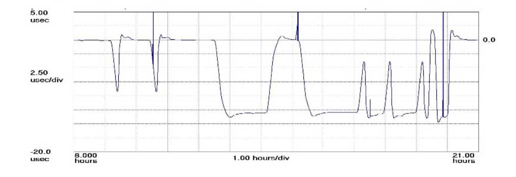
The plot shows how the anomaly event impacted one GPS timing receiver during the day. (Click to enlarge | Chart: Chronos Technology)
“On 26 January at 12:49 a.m. MST, the 2nd Space Operations Squadron at the 50th Space Wing, Schriever Air Force Base, Colo., verified users were experiencing GPS timing issues. Further investigation revealed an issue in the Global Positioning System ground software which only affected the time on legacy L-band signals. This change occurred when the oldest vehicle, SVN 23, was removed from the constellation. While the core navigation systems were working normally, the coordinated universal time timing signal was off by 13 microseconds which exceeded the design specifications. The issue was resolved at 6:10 a.m. MST, however global users may have experienced GPS timing issues for several hours.” (This excerpt from an U.S. Air Force communiqué appears in a brief news account.)
“The Joint Space Operations Center at Vandenberg AFB has not received any reports of issues with GPS-aided munitions, and has determined that the timing error is not attributable to any type of outside interference such as jamming or spoofing. Operator procedures were modified to preclude a repeat of this issue until the ground system software is corrected.”
Companies and their time-servers around the world were subsequently hit by up to 12 hours of system warnings after 15 GPS satellites broadcast the wrong time, according to Chronos, a UK-based time-monitoring firm.
Telecommunications companies constitute only a small part of industry users who rely on the highly precise accuracy of time measurements — supplied by GPS — to control data flow through their networks. Global financial networks and trading markets similarly depend on GPS, as do electrical power grids and many other sectors of critical national infrastructure. These companies and networks invest significantly in highly sophisticated equipment to monitor said timing accuracy as conveyed by GPS signals. Because billions, make that trillions — or actually even more — are riding on it.
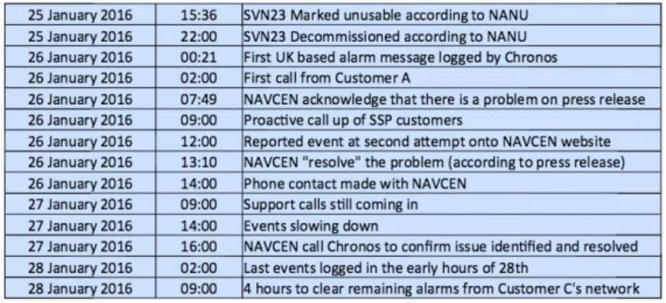
A week after the eye blinks, Chronos Technology released a white paper describing the ensuing fallout for its clients, who are timing equipment users in more than 50 countries around the world. Table 1 from the white paper reports the experience of a few during the event. One company registered nearly 2,500 alarms from its timing equipment during the outage.
Click to enlarge. (Table: Chronos Technology)
At one point during the crisis, according to the white paper, “it appeared that the GPS error had cleared and the Chronos SSP Manager was able to force the units out of holdover. However the scale of the problem escalated as these sites went back into holdover along with dozens of other sites suffering GPS-based timing issues. It was apparent at this point that there was something amiss with the GPS constellation itself.”
Later on, the report states, “This event linked to SVN23 has been one of the most significant service affecting issues for GPS timing users and sits alongside the April 1st 2014 GLONASS outage in scale — however its impact on global timing services is much more extreme.”
Ominously, “Chronos is aware of other more catastrophic impacts to networks and non-telecom applications which were not under supply and support contracts.”
As Loran Is Our Savior. At least one timing-reliant company was not disturbed by the problems, because it was testing an alternative timing service provided by enhanced Loran (eLoran) signals.
Unfortunately for them — and for the rest of us — eLoran has a very uncertain future. In fact, they were lucky to have an eLoran signal at all on January 26, because it was supposed to have been turned off on December 31. Somebody must have forgotten to tell the operators at the Anthorn giant antenna field in Cumbria to go home.
France, Norway, and the United Kingdom, three countries that had been keeping eLoran alive, officially abandoned the effort at the end of last year, reportedly because of lack of leadership from the United States.
The U.S. government decommissioned all its Loran stations a few years ago, even going to the extent of blowing some of them up (perhaps to prevent them from falling into the hands of subversives). Despite a recent reinvigorated interest in enhanced Loran technology, it may be too little, too late.
Whoa, Nellie. The first recorded use of the term “back-up technology” occurred in 1892, when farmers were urged not to prematurely abandon their mules in favor of John Froehlich’s new gasoline tractor.
Dan Albone on his prototype Ivel Agricultural motor. (Image: North Bedfordshire Gazette, 1903)
That admonition, however prudent, has since passed from view. But the concept remains sound. It has surfaced many, many times in GPS World magazine. Certainly not the first incidence, but the farthest back that I can retrieve via search on our website, came in 2007 from Defense contributing editor Don Jewell. “Why do we need a backup? Here is a classic case in point.” He describes a Joint Navigation Conference briefing on a surprise jamming incident that had occurred in January of that year.
In 2009, we reported on an Independent Assessment Team (IAT) report that “unanimously recommends that the U.S. government complete the eLoran upgrade and commit to eLoran as the national backup to GPS for 20 years.” The report was written in 2007, but quashed by the Department of Transportation and Department of Homeland Security (DHS) Executive Committees that commissioned it. Its public release came only after an extensive Freedom Of Information Act (FOIA) battle.
The U.S. government proceeded, despite its paid experts’ recommendations, to blow up those old Loran stations. The current renewed interest and the Wildwood experiment are worthy — more than worthy. Can they prevail? Can they survive blind reliance on a single string of vulnerable technology?
Indubitably, the critical role of GPS back-up was advanced prior to 2007, I just can’t document it this morning by deadline. For the sake of argument, let’s take April 12, 2007, as our start.
We are now 3,229 days out. That’s 77,496 hours, or nearly 279 million seconds. Correct me if wrong, but that appears to make 21.5 million-million times the length of January’s GPS timing error. Surely sufficient to blink a few times, scratch one’s head, and wonder.
On Jan. 26 at 12:49 a.m. MST, the 2nd Space Operations Squadron (2 SOPS) at the 50th Space Wing, Schriever Air Force Base, Colo., verified users were experiencing GPS timing issues. Further investigation revealed an issue in the GPS ground software that only affected the time on legacy L-band signals. This change occurred when the oldest vehicle, SVN 23, was removed from the constellation.
While the core navigation systems were working normally, the coordinated universal time timing signal was off by 13 microseconds, which exceeded the design specifications. The issue was resolved at 6:10 a.m. MST; however, global users may have experienced GPS timing issues for several hours.
U.S. Strategic Command’s Commercial Integration Cell, operating out of the Joint Space Operations Center, effectively served as the portal to determine the scope of commercial user impacts. Additionally, the Joint Space Operations Center at Vandenberg AFB has not received any reports of issues with GPS-aided munitions, and has determined that the timing error is not attributable to any type of outside interference such as jamming or spoofing.
Operator procedures were modified to preclude a repeat of this issue until the ground system software is corrected, and the 50th Space Wing will conduct an Operational Review Board to review procedures and impacts on users. Commercial and Civil users who experienced impacts can contact the U.S. Coast Guard Navigation Center at (703) 313-5900.
Signals from both Galileo satellites launched March 27 are now transmitting signals.
Researchers at Université de Liège and at the German Aerospace Center (Deutsches Zentrum für Luft- und Raumfahrt, or DLR) reported on May 21 that the first of the full-operational-capability (FOC) satellites had begun transmitting standard L-band signals. The satellite, designated Galileo 8, is using pseudorandom-noise-code identifier 22.
The first E1 and E5 signals from Galileo 8 were received at an International GNSS Service Multi-GNSS Experiment tracking station in Windhoek, Namibia, at about 11:32 UTC on May 21. The satellite’s signals were subsequently tracked by a station in Wettzell, Germany, and then by others.
The other satellite, Galileo 7, began transmitting standard L-band signals on May 25. The first E1 and E5 signals from Galileo 7 were received around 17:00 UTC. The satellite is using PRN code 26.
The signals will be set unhealthy for use until satellite commissioning is completed.
Galileo 7 is also known as GSAT0203, FOC-FM3 and as NORAD object 40544. Galileo 8 is also designated GSAT0204, FOC-FM4 and NORAD object 40545.
NovAtel Inc. has launched the GPS-704-WB wideband antenna, which supports L-band and the frequencies of all current GNSS constellations (GPS, GLONASS, Galileo and BeiDou), including B3 and E6 signals. Customers can use the antenna for GPS-only or multi-constellation applications, giving application developers flexibility, NovAtel said.
The phase center offset of the antenna remains constant as the azimuth and elevation angle of the satellites change, making it a good choice for baselines of any length. Installation is easy, NovAtel said. because the antenna shares the same form factor as other NovAtel GPS-700 series antennas. It is enclosed in a durable, waterproof housing. Its compact, lightweight size makes it suitable for a wide variety of environments and applications, the company said.
NovAtel’s SMART6-L attaches to the Relay RTK radio module to create a single unit for easy system integration.
NovAtel Inc. has launched the Relay RTK radio module, a docking station that provides radio connectivity for its SMART6-L L-band capable GNSS receiver.
The Relay RTK module combined with NovAtel’s SMART6-L receiver creates a compact, easy to integrate positioning solution, NovAtel said. It is available in four radio versions: 400 MHz UHF licensed band; 900 MHz UHF unlicensed band; HSPA (3G) cellular; and CDMA (1xRTT/EV-DO) cellular. The CDMA version is approved for use on the Verizon cellular network.
The 400 MHz and 900 MHz versions support both base and rover configurations. The base station is configured via the integrated web-server/Wi-Fi access point using the web browser on any compatible personal computer, tablet or smartphone. The cellular radio versions support the reception of NTRIP and RTK corrections over the cellular network.
SMART6-L customers can connect to the Relay using their existing SMART6-L interface cables. Relay has support for both screw and magnetic mounting; optional mounting plates are available for roof and pole mounting. NovAtel’s SMART6-L with Relay provides the same level of performance as a standalone SMART6-L unit with the added convenience of radio connectivity to support RTK and NTRIP corrections.
Editor’s Note: See the report from the European Space Agency here.
An official with the European Space Agency has confirmed that the sequence of maneuvers to adjust the orbit of the second of two Galileo satellites launched into a wrong orbit in August 2014 has been completed.
The orbit of the first satellite, known variously as GSAT0201, Galileo FOC-FM1 or Galileo 5 (with COSPAR ID 2014-050A and NORAD ID 40128) was raised during operations carried out in November, and the satellite began transmitting L-band signals on Nov. 29.
Maneuvering of the second satellite (GSAT0202, Galileo FOC-FM2 or Galileo 6, with COSPAR ID 2014-050B and NORAD ID 40129) began around Jan. 15. The procedure took somewhat longer than that for the first satellite as it also involved changing the mean anomaly of the satellite to be about 180° away from that of the first satellite.
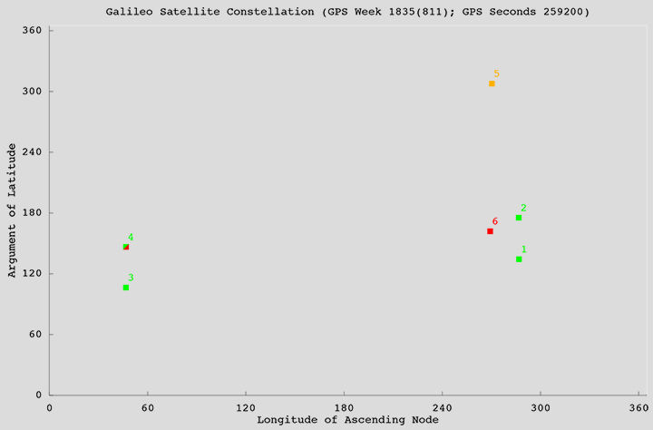
The locations of the satellites in the Galileo constellation are shown in the accompanying figure. Satellites in green are transmitting a full complement of L-band signals. Galileo 4 (GSAT0104), one of the in-orbit validation satellites, suffered a power anomaly and only transmits on the E1 frequency. Galileo 5 is transmitting L-band signals but its orbit cannot be properly represented in the Galileo broadcast almanac. Galileo 6 has not started transmitting valid L-band signals yet.
Officially, all Galileo signals are currently declared unavailable during an extended period of testing following ground segment upgrades. However, signals continue to be monitored by stations participating in the International GNSS Service Multi-GNSS Experiment.
Starting Friday, September 5, GPS satellite SVN-35 will resume transmitting L-band signals using PRN03, according to a Notice Advisory to Navstar Users (NANU) issued today.
According to GPS WorldAlmanac editor Richard Langley, the resumption is being done in an effort to determine the exact status of SVN-35’s remaining clock. However, the satellite will remain unusable as the Air Force conducts its tests.
Below is the full text of the NANU.
NOTICE ADVISORY TO NAVSTAR USERS (NANU) 2014069 NANU TYPE: GENERAL
*** GENERAL MESSAGE TO ALL GPS USERS ***
On approximately 05 Sep 2014 SVN35 will resume transmitting L-band utilizing PRN03. At L-band activation, SVN35/PRN03 will be unusable until further notice. Additionally, no broadcast almanacs will include SVN35/PRN03 until further notice.