The U.S. Air Force is directing transmission of continuous CNAV message-populated L2C and L5 signals starting in April 2014. The move is designed to help development of user equipment compatible with the civil signals. Full text of the CNAV memo appears below.
MEMORANDUM FOR THE NATIONAL COORDINATION OFFICE FOR SPACE BASED POSITIONING, NAVIGATION AND TIMING
ATTENTION: DR. JAN BRECHT-CLARK
FROM: AFSPC/CC
Peterson AFB CO
SUBJECT: Early Civil Navigation (CNAV) Message-Populated L2C and L5 Signals
I have directed transmission of continuous CNAV message-populated L2C and L5 signals prior to fielding the Next Generation Operational Control Segment. This provision of populated signals will facilitate development of compatible user equipment and a CNAV Operations Concept.
The message-populated broadcast is projected to begin April 2014. Users should expect initial CNAV signal accuracy to be less than the legacy signals. Upon full implementation in December 2014, CNAV signal accuracy should meet or exceed the legacy signals.
Air Force Space Command is committed to ensuring GPS remains the world’s gold standard for PNT services. The user community can anticipate additional information on CNAV message implementation in the months preceding the initial April broadcast.
By Oliver Montenbruck, Richard B. Langley, and Peter Steigenberger
Over the past several years, some users of the GPS navigation system have already benefitted from the addition of various new signals in addition to the legacy C/A- and P(Y)-code. With the introduction of the Block IIR-M satellites in 2005, a new civil signal (L2C) was transmitted on the L2 frequency, and a new signal on a new frequency (L5) was introduced as a standard signal with the Block IIF satellites beginning in 2010. These new signals provide direct access to dual-frequency observations and thus enable improved ionospheric corrections for civil, including aeronautical, users. In addition, a new Civil Navigation (CNAV) broadcast message has been defined in the GPS Interface Specifications (IS-GPS-200 and IS-GPS-705).
This message will be transmitted jointly on the L2C and L5 signals and provides a variety of useful new parameters. Compared to the legacy L1 C/A-code navigation message, the CNAV message also offers an increased flexibility concerning the type, sequence, and repeat rate of specific messages.
CNAV messages have already been broadcast over the past two years by the Michibiki (QZS-1) satellite of the Japanese Quasi-Zenith Satellite System (QZSS), which shares many aspects of the GPS signal design. In contrast to this, Block IIR-M and IIF GPS satellites have only transmitted dummy messages so far and a fully operational CNAV transmission is only foreseen once the ongoing modernization of the GPS control segment has been completed.
Triggered by various interest groups, the Global Positioning Systems Directorate has just conducted a first test campaign with live CNAV transmissions on L2C and L5 over the two-week period from June 15 to 29 (see Global Positioning System Modernized Civil Navigation (CNAV) Live-Sky Broadcast Test Plan.) It served as a first opportunity for end users and receiver manufacturers to test the decoding and use of the new messages under a wide range of different configurations.
CNAV messages have a common length of 300 data bits and are identified by a message type number that signifies their contents. The messages presently defined for GPS are summarized in Table 1. For QZSS, complementary messages have been established, which enable, among other features, a rebroadcast of GPS-specific data to QZSS users.
Table 1. Summary of CNAV message types transmitted by space vehicles (SVs). Messages marked by an asterisk were transmitted during the recent CNAV test campaign.
Message
Type
CNAV Message Title
Function/Purpose
0*
Default
Default message (transmitted when no message data is available)
10*
Ephemeris 1
SV position parameters for the transmitting SV
11*
Ephemeris 2
SV position parameters for the transmitting SV
12*
ReducedAlmanac
Reduced almanac data packets for seven SVs
13
Clock Differential Correction
SV clock differential correction parameters
14
Ephemeris Differential Correction
SV ephemeris differential correction parameters
15*
Text
Text (29 eight-bit ASCII characters)
30*
Clock, Iono & Group Delay
SV clock correction parameters, ionospheric and group delay correction parameters (inter-signal correction parameters)
31
Clock & Reduced Almanac
SV clock correction parameters, reduced almanac data packets for four SVs
Other than the legacy L1 navigation message, which adheres to a fixed order of subframes, the sequence of CNAV messages can be varied widely to provide users with an optimized set of low latency information and parameters that change infrequently. As a baseline, the two ephemeris message types 10 and 11 are combined with any of the clock-and-auxiliary data messages (types 30 through 37) to provide users with the orbit and clock data of the received satellites. With a transmission duration of 12 seconds per CNAV message on L2C, a minimum of 36 seconds is required to transfer this information to the user if no other messages are transmitted. On L5, which operates at twice the data rate, a new frame is transmitted once every 6 seconds yielding a minimum of 18 seconds for the broadcast of ephemeris and clock data.
The recent test campaign started at 18:00 GPS Time on Saturday, June 15, 2013, with the transmission of message types 10, 11, 15, and 30 on a first space vehicle (PRN24) and included PRN12 from 18:42 onwards. Other space vehicles were sequentially phased in until all active IIR-M and IIF satellites (except for the recently launched IIF-4 satellite) transmitted CNAV on the supported signals. When the test ended exactly two weeks later (June 29, 18:00 GPST), all participating satellites were transmitting a complex master frame of 15 x 4 = 60 individual messages, which was repeated once every 12 minutes (on L2C). Each minor frame comprised the two ephemeris messages and at least one clock-data message (see Table 2).
Table 2. Sequence of message types in a CNAV master frame.
Message Types
10
11
15
30
10
11
32
33
10
11
12
35
10
11
12
30
10
11
12
33
10
11
12
35
10
11
12
30
10
11
32
33
10
11
15
35
10
11
32
30
10
11
12
33
10
11
12
35
10
11
12
30
10
11
12
33
10
11
12
35
Other messages included a reduced almanac (message type 12) and a text message (message type 15) with dummy content (“THIS IS A GPS TEST MESSAGE.”)
The CNAV data were recorded by selected multi-GNSS monitoring stations of the German Aerospace Establishment (Deutsches Zentrum für Luft- und Raumfahrt or DLR) and the University of New Brunswick (UNB), which were specifically configured to record raw GPS navigation frames in addition to the normal observation data. The stations are located at Singapore (SIN0); Sydney, Australia (UNX2); Maui, U.S.A. (MAO0); and Hartebeesthoek, South Africa (HRAG); as well as Fredericton, Canada (UNB) and are equipped with either Javad Delta-G2/G3TH or NovAtel OEM6 receivers. Following initial validation, the raw and decoded data from the CNAV test will be made available to interested users through the Multi-GNSS Experiment (MGEX) of the International GNSS Service (see http:/igs.org/mgex) to facilitate the development of user software and suitable data formats (such as an extended RINEX navigation message format).
The CNAV orbit and clock data were updated once every two hours and offer a slightly higher bit resolution than their legacy counterparts. However, the accuracy of the ephemeris data has not yet been evaluated nor compared to that of the L1 C/A-code navigation data.
As indicated above, the CNAV data can also provide a particularly compact form of almanac data known as the reduced almanac. It does not offer clock information (that is not normally required for a signal search) and assumes a circular orbit, which reduces the overall accuracy. Still, it can be transmitted (and repeated) in a much shorter time interval than the legacy almanac, which requires a total of 12.5 minutes. Each reduced almanac message (message type 12) provides orbit information for a total of seven satellites and it takes a set of five such messages to convey information for a complete constellation. For the master frame layout described above, the full constellation reduced almanac is repeated twice within 12 minutes on L2C (and half this time on L5).
Novel types of CNAV data not covered by the legacy navigation message include the differential code biases (also known as inter-system corrections or ISCs), which are required for pseudorange-based positioning with signals other than the legacy P(Y)-code (in addition to the established Timing Group Delay parameter or TGD). An overview of TGD and ISC values broadcast by the various satellites participating in the CNAV test is given in Table 3.
Table 3. Differential code biases (in nanoseconds) of GPS Block IIR-M and IIF satellites broadcast during the test campaign as part of the message type 30 CNAV messages.
SV Type
SVN
PRN
TGO
ISC L1CA
ISC L2C
ISC L5I5
ISC L5Q5
IIR-M
48
07
-10.71
-0.84
6.52
IIR-M
50
05
-10.24
-0.32
5.41
IIR-M
52
31
-13.04
-0.55
7.36
IIR-M
53
17
-10.24
-0.84
6.17
IIR-M
55
15
-10.24
-0.47
5.62
IIR-M
57
29
-9.31
-0.76
5.06
IIR-M
58
12
-12.11
-0.76
6.64
IIF
62
25
5.59
-2.07
-5.24
-0.38
-0.87
IIF
63
01
8.38
-2.30
-7.57
0.38
2.15
IIF
65
24
2.79
-0.26
-2.27
2.27
3.70
Another important achievement is the provision of Earth orientation parameters (EOP) in message 32, which provides GPS users with access to the celestial reference frame. EOPs were transmitted during the second test week and updated on a daily basis (see Table 4). Knowledge of these parameters is of particular interest for GPS-based orbit determination and navigation of spacecraft (in low Earth orbit), which is preferably referred to an inertial rather than an Earth-fixed coordinate system.
Table 4. Daily Earth orientation parameters from the CNAV test campaign (pole coordinates and dUT1 (UT1-UTC) time differences and derivatives).
Epoch (GPST)
x_p
(arcseconds)
x_p_dot
(arcseconds per day)
y_p
(arcseconds)
y_p_dot
(arcseconds per day)
dUT1
(seconds)
dUT1_dot
(seconds per day)
June 22, 0:00
0.13517
0.00104
0.39657
-0.00054
0.06341
-0.00046
June 23, 0:00
0.13621
0.00102
0.39604
-0.00056
0.06295
-0.00049
June 24, 0:00
0.13740
0.00101
0.39535
-0.00058
0.06231
-0.00053
June 25, 0:00
0.13815
0.00099
0.39487
-0.00060
0.06164
-0.00063
June 26, 0:00
0.13846
0.00096
0.39443
-0.00062
0.06078
-0.00067
June 27, 0:00
0.13885
0.00094
0.39381
-0.00064
0.06004
-0.00067
June 28, 0:00
0.13947
0.00093
0.39310
-0.00066
0.05909
-0.00063
June 29, 0:00
0.13987
0.00090
0.39246
-0.00068
0.05842
-0.00053
Overall, CNAV offers exciting prospects for improved GPS utilization and users may look forward to the next test campaigns, which will tentatively be conducted once every six months.
As a side note, it should be mentioned that individual satellites could be observed to transmit various types of non-standard CNAV messages as well as CNAV messages with improper data (such as an invalid week count) after the end of the main test campaign. Various receivers in the MGEX network, which were processing the received CNAV messages internally and which put full confidence in their proper contents, were mislead by such information. During the actual test campaign, all data appeared fully valid and no problems were reported by the stations.
OLIVER MONTENBRUCK is the head of the GNSS Technology and Navigation Group at DLR’s German Space Operations Center in Oberpfaffenhofen, Germany.
RICHARD B. LANGLEY is a professor in the Department of Geodesy and Geomatics Engineering at the University of New Brunswick, Fredericton, New Brunswick, Canada.
PETER STEIGENBERGER is a staff member in the Institut für Astronomische und Physikalische Geodäsie of the Technische Universität München (TUM) in Munich, Germany.
U.S. Air Force Space Command is now testing CNAV capabilities on the GPS L2 and L5 signals. The initial CNAV Live-Sky Broadcast began June 15 and will take place until June 29. Civil users and manufacturers are invited to participate.
The GPS Directorate (SMC/GP) is implementing the CNAV (Civil Navigation) Test Program, conducting Live-Sky CNAV testing before deployment of the Next Generation Operational Control System (OCX). CNAV is a capability to be provided by Civil Navigation message types for the purpose of improved GPS navigation through the use of signals L2C and L5.
According to the GPS Directorate, the CNAV Live-Sky testing program will span several years and will evolve to support GPS enterprise and modernized civil navigation performance objectives. Objectives include:
Verify and validate the CNAV requirements specified IS-GPS-200F and IS-GPS-705B.
Facilitate the development of robust IS-compliant L2C and L5 civil receivers.
Below is the latest Notice Advisory about the upcoming test issued to NAVSTAR users. More information can be found in the NAVCEN test plan PDF.
NOTICE ADVISORY TO NAVSTAR USERS (NANU) 2013034 NANU TYPE: GENERAL
*** GENERAL MESSAGE TO ALL GPS USERS ***
The purpose of this notification is to inform users of an upcoming event related to the GPS satellite constellation. Air Force Space Command will be
testing CNAV capabilities on the GPS L2C and L5 signals on Jdays 2013/166-2013/182. There are no planned GPS satellite outages or degradations for this activity. L2C and L5 CNAV message testing should be transparent to GPS receivers that do not process L2C or L5 CNAV. These test events will provide an opportunity for civil users and manufacturers to participate in L2C and L5 evaluation. Details on the test plan are located at the NAVCEN web page. Any military or civil users who encounter user equipment problems during or after testing should contact the applicable POCs identified below as soon as possible. Aviation users should file reports consistent with FAA-approved procedures. Users are cautioned that L2C and L5 signals are not operational.
U.S. Air Force Space Command has issued a notice that CNAV capabilities on the GPS L2C and L5 signals will be tested in June. No GPS satellite outages are planned. Below is the official notice.
Notice of Test
A Notice by the Air Force Department on 03/20/2013
Action: GPS Test Notice.
Summary: The purpose of this notification is to inform users of an upcoming event related to the GPS satellite constellation. U.S. Air Force Space Command will be testing CNAV capabilities on the GPS L2C and L5 signals on 15-29 June 2013. There are no planned GPS satellite outages for this activity. The broadcast navigation messages will be in compliance with IS-GPS-200 and IS-GPS-705. L2C/L5 CNAV testing will be transparent to GPS receivers that do not process L2C or L5 CNAV. U.S. Air Force Space Command expects to conduct one to two CNAV tests per year over the next few years. These test events will provide an opportunity for civil users and manufacturers to participate in L2C/L5 evaluation and will result in enhanced provider and user readiness for L2C/L5 operations once the Next Generation GPS Operational Control System comes online in 2016.
The draft test plan is available. The draft test plan communicates details of the broadcast, data collection, and results reporting plans.
U.S. Air Force Space Command and the National Space-Based Positioning, Navigation, and Timing Systems Engineering Forum (NPEF) encourage L2C and L5 users and receiver manufacturers to review the test plan, provide comments, and participate in the evaluation process.
Any military or civil users who encounter user equipment problems during or after testing should contact the GPS Operations Center (GPSOC) (military), NAVCEN (civil, non-aviation) as soon as possible. Aviation users should file reports consistent with FAA-approved procedures.
FOR FURTHER INFORMATION CONTACT:
Send all questions or concerns regarding the CNAV Test Plan to [email protected].
Henry Williams Jr.
Acting Air Force Federal Register Liaison Officer
With apologies to the Bard of Avon, as I paraphrase his prose, 2C or not 2C — that is the question for millions of GPS users and has been for several years. Indeed, over the past seven years hardly a week has gone by without an email or inquiry about the status of the GPS L2C signal.
The name “L2C” refers to the radio frequency used by the signal (1227 MHz, or L2) and the fact that it is for civilian use, but of course it will also be used by the military. There are also two military signals on the L2 frequency. In the past couple of months inquiries concerning L2C have become an almost everyday occurrence. Plus I have it on good authority that it was a topic of conversation at recent a PNT EXCOM or Executive Committee Meeting.
However, when I started making inquiries I was met with an interesting dichotomy. One group of users actually laughed and accused me of having a Don Quixote complex and tilting at windmills, since this debate has been continuing for over seven years, while other more sanguine user groups are seriously interested in the future of L2C. Here is what I discovered.
What is L2C?
According to the official U.S. government website concerning GPS, “L2C is the second civilian GPS signal, designed specifically to meet commercial needs. When combined with L1 C/A [ed. coarse acquisition] in a dual-frequency receiver, L2C enables ionospheric correction, a technique that boosts accuracy. Civilians with dual-frequency GPS receivers enjoy the same or better accuracy as the military. For professional users with existing dual-frequency operations, L2C delivers faster signal acquisition, enhanced reliability, and greater operating range. L2C broadcasts at a higher effective power than the legacy L1 C/A signal, making it easier to receive under trees and even indoors. The Commerce Department estimates L2C could generate $5.8 billion in economic productivity benefits through the year 2030. The first GPS IIR(M) satellite featuring L2C launched in 2005. Every GPS satellite fielded since then has included an L2C transmitter.”
Problems
So while this would appear to be a “no brainer” as it were, especially the $5.8 billion in economic benefits, it appears the Global Positioning System is actually at a crossroads and the decision makers are apparently on the horns of a dilemma. For some groups of users, the laudable global PNT (position, navigation and timing) gold standard is looking a bit tarnished of late but has an opportunity to shine once again. The question and future perception of GPS by many global users simply revolves around implementing full navigation messages on signals that are already in place, namely L2 and L5 with CNAV and M-code with MNAV. So, what’s the issue, you say? The signals are there, and in the case of L2C and M-code, have been for seven years — simply upload a full navigation message and be done with all the ambiguity that has become unwelcome baggage for these modern day signals. Au contraire, mon ami, if it were only that simple.
Now grant you this, should be a simple decision, but remember this is the U.S. government we are talking about — apropos failed budgets, endless continuing resolutions, health care fiascos, and the fiscal cliff — important but in the end actually simple decisions all. Unfortunately, history reflects when the U.S. government is involved, nothing is ever easy and timely decisions are hard to come by. So as not to confuse anyone, especially the players, let’s take this process one step at a time and see what all the fuss is about, shall we?
Problem Statement: The L2C and M-code signal capability has been on orbit for more than seven years, since 2005. In 2009, the 2SOPS began uploading and broadcasting a Message Type Zero on L2C, which, while not a navigation message, does put data on the channel. What users are now asking for is the full navigation message on L2C or CNAV, which is a modern-day navigation message and will have significant advantages for all users. Plus, the signal would be available to potentially more than 3 billion users versus the small subset today that utilizes the L2C carrier phase for RTK (real-time kinematic) operations. Indeed, when compared to the L1 C/A (coarse acquisition) signal, L2C has 2.7 dB greater data recovery (with a navigation message) and 0.7 dB greater carrier tracking.
The bottom line is that, with the addition of a valid and updated CNAV message on L2C, all users, the military included, would immediately have ten more potential navigation signals available, and that number would grow with each new GPS launch. Obviously, the same is true for military users with M-code and for all users with an L5 capability. However, the upgrade process needs to start somewhere, and L2C is the obvious choice since there are essentially no M-code receivers available today and there are approximately between 450,000-500,000 L2C capable receivers already in the hands of users.
Assets
Hardware – Simply put, there are currently 10 satellites (SVs) capable of broadcasting a full navigation message or CNAV message on the L2 signal and MNAV message on the M-code signal, also on L2 and three L5 CNAV capable SVs:
7 – IIRM SVs (does not include SVN-49 which, while capable, is currently in residual and/or test status).
3 – IIF SVs (same capabilities as the IIRMs and also capable of broadcasting an L5 signal with CNAV).
While the lack of L2C monitor stations has historically been used as a reason for not broadcasting the new CNAV navigation messages, today there are literally more than one hundred L2C- and L5-capable monitoring stations, which includes the NASA JPL (Jet Propulsion Laboratory) monitoring stations. Logs from several independent monitoring stations show that at any given time there are from one to three L2C SVs visible for the majority of global users, including our warfighters, who in the mountains of Afghanistan need all the signal availability we can provide.
Plus, of the estimated 450,000-500,000 fully capable L2C receivers, several thousand of those are in the hands of our warfighters. Trimble started building in the L2C and L5 CNAV capability as far back as 2003, a full two years before the first L2C launch, for users that wanted the option. However, that option has never been fully tested with live on-air CNAV coded transmissions and they need to be. More on testing later.
From a global user perspective, Japan has essentially leapfrogged the U.S., since the L2C and L5 signals with full CNAV messages are already being broadcast on the Japanese QZSS navigation satellite QZSS-1.
Software was initially thought to be an issue, but according to my sources, the current MNAV or M-code full navigation message is remarkably similar, as to be almost identical to the CNAV messages for L2C and L5, and MNAV has already been shown to work well on the ten GPS SVs capable of broadcasting the M-code signal. Granted, it is not fully integrated into the current OCS or operational control system known as AEP or Architecture Evolution Plan, but then not many future capabilities are, so this is really not an issue since manual processes abound in the current OCS. The L2C, L5 and M-code full navigation messages are supposedly still part of the plan for OCX or the future operational control system for GPS, which should be up and working sometime in early 2017. This would be twelve years after the L2C and M-code signal capability was first placed on orbit.
Timelines
Given those timelines, some would say, hey that’s only four years from now, maybe five if you count testing, and the full navigation message might actually be turned on. But, alas, rumors abound that there is a government agency apparently objecting to the immediate activation of L2C and L5. This agency, and it is not hard to ferret out exactly which one, wants extensive testing to ensure there will be no complications with the WAAS or Wide Area Augmentation System broadcasts, and as an alternative plan it proposes waiting until all the L5 satellites are on orbit before activating navigation messages on L2C or L5. Let’s do the math – that’s 24 L5 SVs, before the L2C and L5 PNT signals are activated with full navigation messages. At one launch per year, the current GPS launch rate, and it matters not whether it is a IIF or a III, and with three L5 SVs already on orbit, that effectively means we will see all 24 L5 SVs on orbit sometime in 2034, if indeed the II-F SVs are truly the first 30-year GPS SVs. If not, then it could be as late as 2037. However, given the average life span of GPS SVs today, it is more than likely that by 2037 every single L2C, L5 and M-code capable satellite on orbit today will have been disposed of without ever having broadcast any of the new signals for which they were designed. Now, how’s that for a lachrymose plan?
Fortunately, this alternate long-term “plan’ has not a prayer of passing, dare I utter the words, the dreaded Washington Post test. Never having purposely written anything for the Washington Post, even though several of my articles have been quoted and misquoted there, it is still a force to be reckoned with in our nation’s capital, simply because the Washington Post continually asks the question, “Is this a wise use of taxpayer’s money?” The answer for the alternative GPS L2C and L5 plan is obvious.
Personnel and monetary issues are always mentioned in the context of new GPS capabilities; however, I have no doubts that the absolutely superb blue suit operators, tacticians and support contractors at 2SOPS are more than capable of performing the simple actions of uploading the new navigation messages on their own.
Sure, times are tough but the blue suit operators and their on-site support staff, at the 2SOPS, have proven themselves time and again to simply be the best in the business. They have brought GPS SVs back from the dead, they (with Braxton Technologies Software) maintain residual satellites that everyone thought for years was an impossible task, and they have saved SVs for important missions that everyone else thought should have been abandoned. We don’t give the fine men and women at Schriever AFB, the 50th Space Wing and the 2SOPS (2nd Space Operations Squadron) enough credit, and I am not about to sell them short. I am convinced the signals in question can be uploaded with full navigation messages, tested and made operational, even if only on a test basis, within six months without expensive outside help.
Full-Scale Testing
This brings us back to the full testing proposal, which actually makes a lot of sense. We (all users) need immediate full scale and extensive operational evaluations that confirm “we have it right” with the CNAV and MNAV data messages. We should encourage manufacturers to participate in this testing process to ensure their GPS devices meet specifications and are not flawed because of a misinterpretation of an interface specification. The GPS equipment manufacturers would be the first to embrace this approach. The manufacturers and users need open-air full-scale testing with valid CNAV messages being broadcast by numerous satellites to ensure they have coded the L2C, L5 and M-code receivers properly.
Immediate testing is the key here, because otherwise under one proposed plan we will only find out if there is a problem with full end-to-end testing of the L2C CNAV signal and user equipment 13 years after manufacturers began fielding the supposed and promised capability. Under the wait for L5 FOC (full operational capability) plan, we won’t find out if the implementation of specifications are correct for another 20-plus years. Personally, I find this to be unacceptable. We need to begin the immediate six-month test plan now.
The aviation community has the mantra, “Test it as you fly it.” We should not do any less. A full six-month evaluation is absolutely appropriate and should be undertaken now. We cannot afford to repeat the 5.5C debacle. [ed. click to read more about 5.5C].
Users, of course, are the prime concern. If you or your organization, including the military, can benefit from 23 more navigation signals today (and three additional signals each year from now until 2034), one of them being the strongest GPS signal to ever be broadcast (L5 with CNAV), and you want/need those signals active now, then please let us know. You may email me at [email protected].
Stand up and Be Heard
Although some of my comments have been a bit tongue-in-cheek, this is indeed your chance to be heard and to make a difference. Let there be no mistake: there is no other PNT system in existence today, planned or unplanned, on the drawing boards or on PowerPoint slides that approaches the capability, availability, reliability, longevity, accuracy and integrity of the Global Positioning System. The folks at Air Force Space Command have been and continue to be admirable stewards. We just need to let them go about their business without undue restrictions.
Dare to Compare
If you want to know exactly how the GPS compares to other PNT systems, consider that the Russian GLONASS (Globalnaya Navigatsionnaya Sputnikovaya Sistema), which came into existence in 1979 only one year after the first GPS launch, has only been Fully Mission Capable (FOC) as a global PNT system for about two years, and that dubious status is literally day-to-day as it teeters on that magic number of 24 available SVs broadcasting multiple PNT signals simultaneously. Contrast that to the GPS, which currently has 32 active SVs with several additional SVs in residual status. Three GPS SVs are nearing, have attained or will soon attain 20 years on orbit. One of our SVs has been on orbit for more than 22 years. GLONASS has serious problems merely attaining an average SV life of less than five years on orbit. Even the vaunted Chinese are experiencing serious technical, longevity and integrity issues with their multiple PNT constellations. It is just not as easy as it sounds. So yes, GPS is the global PNT gold standard, and its stewards must always strive to improve and lead the way. The GPS must continue to grow and innovate or risk being left behind. This is your chance to contribute to that leadership role. Let your opinion be heard.
Until next time Happy New Year, happy navigating, and keep those card, letters and emails coming.
JAVAD GNSS has commented on some news that its receivers can track a new L5 signal from the Indian SBAS satellite, GSAT-8, launched on May 20. In a further explanation to GPS World, CEO Javad Ashjaee explained, “All owners of our products can track it. The only thing is that if customers have not updated their firmware for a long time, they should update to recent firmwares released earlier. They need to update their firmware, which is free of charge and is posted on our website. All of our customers with recent firmware versions can track the GAGAN L5 signal.”
An earlier report from CANSPACE that appeared on the GPS World website said, in part, “Although GSAT-8 reportedly carries a dual-frequency transponder, no L5 signals from this satellite have yet been detected by International GNSS Service tracking stations.”
The JAVAD GNSS statement on September 30 said “Report of GPS World that GAGAN PRN127 does not transmit L5 signal is not correct. Our receivers track it. This graph shows code-phase measurements for this signal.” The web page displays this figure:
A check with a University of Bern, Switzerland, report of stations participating in the IGS M-GEX campaign on October 2 found that a number of stations are tracking the L1 signal from GSAT-8 but none are tracking the L5 signal yet due to issues with receiver firmware. However, various stations in the Cooperative Network for GNSS Observation (formerly the Cooperative Network for GIOVE Observation, still abbreviated CONGO), using Javad Triumph receivers, have tracked GAGAN L1 and L5 signals for more than half a year. No detailed analysis of these measurements has been performed so far.
Javad Ashjaee, founder and CEO of JAVAD GNSS, has filed a letter with the U.S. Federal Communications Commission (FCC) concerning his company’s development of technical possibilities in GNSS filter designs and components. He states “I hope this will be helpful in establishing realistic guidelines for the characteristics of high-precision GNSS receivers that will be used in critical applications.”
Below is the full text of the letter.
September 7, 2012
The Honorable Julius Genachowski
Chairman
Federal Communications Commission
445 12th Street, S.W.
Washington, D.C. 20554
The Honorable Lawrence E. Strickling
Assistant Secretary for Communications and Information
National Telecommunications & Information Administration
United States Department of Commerce
1401 Constitution Avenue, N.W.
Washington, D.C. 20230
Dear Chairman Genachowski and Assistant Secretary Strickling:
In this communication I want to inform you of the current status of technical possibilities in GNSS filter designs and components. I hope this will be helpful in establishing realistic guidelines for the characteristics of high precision GNSS receivers that will be used in critical applications.
We have improved our previous L1 filter and have extended the design to include all commercial GNSS bands.
Figure left above is our filter that protects GPS L1, Galileo L1 and GLONASS L1 bands. It brings in all the useful signals intact and rejects out of band signals with the slope of about 12 dB/Mhz. Similarly, Figure right above is our filter that protects GPS L2, GPS L5, GLONASS L2 and Galileo L5 and has slope of about 9 dB/Mhz.
These filters have been extensively tested with five different innovative tests and prove that the filters also improve the performance of GNSS receivers. These extensive innovative tests are embedded in the receivers that we mass-produce today and every user can test their receivers in all environments. These tests are much more extensive than those previously employed by PNT and other organizations. These embedded tests are not only much more extensive, but it takes only a few minutes to perform these by any novice user by clicking some receiver buttons. Compare that to the limited tests by PNT and others that took weeks to perform and needed experts with very expensive equipment in some laboratories to perform.
These filters not only protect GNSS signals against all LightSquared signals (10L, 10H and 10R handsets) but also from all similar signals that may appear near all commercial GNSS bands in the future. We are proud that our filters help allow better usage of these precious bands, in particular for broadband wireless communication that our country desperately needs.
These filters apply to wideband high precision GNSS receivers and the cost is even less than earlier conventional filters. The case of narrow-band low precision receivers (e.g. Garmin) is much simpler, as has been demonstrated by GPS receivers in more than 300 million cell phones and mobile devices which are not affected by LightSquared signals. The low precision receivers (L1 C/A code only) require filter slopes 10 times less steep than those presented here and do not necessitate additional costs.
In summary, the technology exists today of improved filter design and better performing GNSS receivers and can actually be done at a cost lower than current conventional GNSS receiver filter designs. I trust that the information that I have presented can be used in establishing the performance guidelines and requirements for all GNSS receivers used in critical applications.
I also would like to invite your representatives to ION-2012 GNSS conference where we present details and answer questions at 2:00 PM on September 20.
Regards,
Javad Ashjaee, Ph.D.
CEO, Javad GNSS
San Jose, California
USA
In late March, I conducted a webinar titled “A Closer Look at L5: The Future of High-Precision GNSS,” in which I discussed the impact that the new GPS L5 signal/frequency may have on high-precision users. Then, in April I was part of a discussion panel-format webinar titled “LightSquared: Our Story So Far.” Many questions and comments arose from both webinars, and I’ll attempt to address those in this column.
First of all, the day after the March 17 webinar, I published a summary with some links and illustrations. If you want to review it to refresh your memory or get a quick overview if you didn’t attend the webinar, click here.
During the March 17 webinar, I conducted several polls. Following are the poll questions with accompanying pie charts to illustrate the results. I think polls are a great tool to gain a better understanding of what your colleagues are thinking.
Poll #1: Does your organization use dual frequency GPS (L1/L2) receivers?
Gakstatter comment: Nothing earth-shattering, but good to know most of the audience members polled are high-precision users.
Poll #2: When do you plan on upgrading your GPS receivers to take advantage of the new L2C and L5 signals?
Gakstatter comment: I think the large number of “I don’t know” answers is due to two major variables. #1 is the economy. If the economy was healthy, I think folks would be more inclined to take the risk upgrade to the latest technology. #2 is the unclear status of GPS and Galileo (and other GNSS). If there was a launch schedule that people knew they could count on and plan for, I think users would be more inclined to upgrade sooner rather than later.
Poll #3: Do you believe that GPS and Galileo will meet their projected deployment dates of 2014/2015?
Gakstatter comment: I understand the skepticism about GPS and Galileo staying on schedule. I don’t think the GPS schedule can push out too far because the FAA requires a full constellation of GPS satellites broadcasting L5 by 2019. The Galileo program is under a lot of pressure to deliver something to the user community. A very important milestone this year is the scheduled September launch of the first two operational Galileo satellites, followed by the launch of a second pair the first quarter of next year. This is an opportunity for the Galileo program to set a new tone and sense of urgency with the user community.
Poll #4: How concerned are you that LightSquared’s initiative might interfere with your GPS operations?
Gakstatter comment: Since the March 17 webinar, there’s been much more information released and published about LightSquared’s potential effect on GPS. In April, I participated in a webinar about LightSquared’s potential effect on GPS with my portion of the webinar specifically addressing high-precision users. I will discuss this later in this article. But, suffice to say that this is a serious issue for the U.S. high-precision GPS user community. LightSquared isn’t going to walk away from this without putting up a big fight, and they have enough of an argument that I could see the FCC (Federal Communications Commission) folding or trying to negotiate a compromise. However, any compromise is likely to have a negative effect on the high-precision GPS user community. Best case scenario, there would be a hit in signal strength. Worst case, you’ll need a hardware upgrade.
As I normally do, a number of questions were raised during the webinar and I will address them here to the best of my ability. I’ll start with the L5 questions and then address some of the questions regarding LightSquared that were asked from both the March and April webinar.
On to the Questions
Question #1: What impact will L5 have on RTK networks?
Gakstatter comment: Great question. There’s only upside in having another GPS frequency to work with. Since the premise behind RTK Networks relies heavily on atmospheric modeling, L5 is going to help. It’s further separated, with respect to frequency, from L1 than L2 and the signal is much stronger than L2. L5 will go a long way in mitigating the effects of the atmosphere on high-precision GPS positioning.
They logistics of implementing L5, by the manufacturers, into RTK Networks may not be so easy. I’m not sure that L5 has been defined well enough in the RTCM specifications and even if it was, I’m not sure how fast manufacturers would implement it. Take, for example, L2C. Even though there are eight satellites broadcasting L2C, I’m not sure there are any RTK Networks taking advantage of it and transparency between different rover manufacturers. However, my gut tells me that manufacturers will be more willing to jump on the L5 bandwagon with a sense of urgency due to the potential significant increase in receiver performance.
Question #2: What could be a better frequency combination in terms of acheiving higher sensitivities: L2C/L5 or L1/L5?
Gakstatter comment: This is another great question. Technically speaking, I’m guessing that L2C/L5 would be a higher-performing combination due to the significantly-improved code structure of L2C (longer code and improved error-correcting methods), which allows the signal to be acquired and tracked better in tough GPS conditions such as under tree foliage.
Question #3:If I toggle on L2C in my current Trimble GNSS; that would give me an extra 8 SV broadcasting
Gakstatter comment: Good, creative thinking, but it doesn’t work that way. You are already using those eight satellites with L1 C/A and L2P. If you utilize L2C from those satellites, you’ll get some marginal gain in performance (assuming the reference station is broadcasting L2C info), but nothing like adding eight additional satellites.
Question #4:What accuracy can be expected from single frequency L5?
Gakstatter comment: It’s going to be better than L1 C/A due to the stronger signal strength (4 x more powerful than L2C) and much longer code structure (than even L2C). With SBAS corrections, we’re seeing about 60cm now with L1 C/A. It will probably be slightly better than that and definitely more robust positioning in marginal GPS conditions.
Question #5:What sort of base line distances can we expect to get with L5?
Gakstatter comment: Using L5 will definitely help with longer baselines, but baselines are already pretty long. Look at the distance between reference stations in RTK Networks today. Some are pushing 70-80km. Will they go longer than 100km? I’m not sure. That would be cool, lowering infrastructure costs of setting up and operating RTK Networks.
Question #6:Using RTK corrections the bandwidth requirements will increase with all these extra satellites will there be more efficient correction broadcast techniques like CMRx?
Gakstatter comment: I agree. I think there will need to be an efficient way of getting the data from reference network to rover. That either means using up more bandwidth on your mobile phone data plan (if you aren’t using UHF/VHF/Spread spectrum radios) or manufacturer’s inventing more efficient formats.
Questions Regarding LightSquared
LS Question #1: LightSquared is going to filter their signal heavily until it will not interfere. They have too much invested to fail.
Gakstatter comment: I agree that LightSquared is not going to walk away from their huge investment. But even if they heavily filter the base transmitters (40,000 of them), I still think there will be some interference. The nature of high-precision GNSS receivers is that they have a wideband RF front-end to take into account better code tracking and accomodate other signals such as OmniSTAR and Starfire.
Also, since LightSquared can’t control the design/production of the mobile phones that will use their system, each of the mobile phones can potentially be a “mobile GPS jammer”. It’s one thing to know the fixed location of each of the 40,000 transmitters, but how about the tens of thousand, hundreds of thousands or millions of mobile phones using the LightSquared infrastructure.
LS Question #2: What do you see as the future for OmniSTAR?
Gakstatter comment:Obviously, OmniSTAR and Starfire people must have major concerns since they are well within the LightSquared frequency spectrum. Ironically, OmniSTAR currently leases satellite bandwidth from LightSquared to broadcast their corrections.
I’m sure they are working on a solution, but I’m not privy to what the options they are considering.
Another option is another delivery method such as NTRIP over mobile phone networks.
LS Question #3: If the signal effects high precision users, it will also effect casual users(hunters, fishermen, and also field technicians – forestry inventory and utility asset mapping – will w ALL need to change the GPS devises currently used today?
Gakstatter comment: It won’t affect casual users as much as high-precision users due to the inherent design of the receivers. But, you’re right about forest inventory, utility mapping, etc. which typically use high-precision receivers. If LightSquared is allowed to continue on their desired path, it’s possible that each high-precision receiver would need to be upgraded (or traded in). That’s the worst-case scenario.
LS Question #4: Would better filters on the GPS receiver front-ends improve the concerns?
Gakstatter comment: Yes, but it’s not clear if high-precision receivers would perform as well with such filters designed into the receiver.
LS Question #5: Is the transmitter the cell phone or Lightsquare base station?
Gakstatter comment: This is a bit outside of my area, but both are transmitters. The LightSquared base stations are designed to broadcast at 1,500 watts while the mobile phone’s highest transmission power is probably 1-3 watts while it’s first connecting to the network. The base stations are transmitting at the band adjacent to GPS on the lower end while the mobile phones transmit in the adjacent band above the GPS. I look forward to reviewing the data in the next working group report to the FCC which includes interference testing from both base station transmitters as well as mobile phones.
LS Quest
ion #6: How does LightSquared affect L2C, if at all?
Gakstatter comment: From what I know and have read, I don’t think it would have any direct affect on L2 since L2 is at 1227MHz, far from LightSquared’s frequency spectrum of 1525MHz to 1559MHz. Indirectly, it would have an affect on L2P as L1/L2 receivers need L1 to utilize L2P. That’s not the case with L2C, but remember there are only eight satellites broadcasting L2C at this time.
Obviously, there is more to discuss. I didn’t touch on the affect on GLONASS receivers (yes, there is a potential problem too). The feedback I received from the LightSquared webinar is that many of you would like to have a webinar that is focused on LightSquared as it relates to the high-precision user (surveying, mapping, engineering, GIS, etc.). I plan to conduct such a webinar in early June. Stayed tuned for the announcement. Hopefully, I’ll have some interesting new data to present from the report due to the FCC on May 15.
Lastly, I attended NOAA’s Space Weather Workshop last week in Boulder, Colorado. I plan on a more comprehensive write-up, but in the mean-time you can check out my Geospatial Solutions Weekly newsletter with some info on my visit there. I’m still working on a GPS space weather notification system I wrote about last summer. I’m getting closer to having something for you.
Yesterday I conducted a webinar titled “A Closer Look at L5: The Future of High-Precision GNSS.” Preparing for it was quite interesting, so I thought I’d share some of the slides I produced (and had produced) for the webinar. I think you’ll find them interesting.
The webinar was focused on discussing the value of the new L5 civilan frequency for GPS/GNSS receivers. An interesting challenge in preparing for the webinar was my attempt at estimating what a satellite constellation of satellites (GPS and others) broadcasting at least L1 and L5 would look like four or five years from now. The point of it was to illustrate that a useful constellation of satellites broadcasting L1 and L5 (as well as L2C) is potentially only four to five years away.
In that timeframe, there are potentially 30 satellites that would be healthy and broadcasting navigation signals on the L1 and L5 frequencies that we can use. How is that possible?
Both GPS and Europe’s Galileo support the new L5 civil frequency (as well as L1). The U.S. has already launched one of the new GPS model IIF satellites. The IIF is currently healthy and broadcasting three civil frequencies; L1 C/A, L2C and L5. There are 11 more of the IIF satellites being built. It’s estimated that all 11 will have been launched into their orbits by ~2015. On the other hand, the first 18 Galileo satellites have been contracted to be built, and it’s estimated that the 18 will be launched into their orbits by ~2015. The Galileo satellites are designed to support L1 and L5 (as well as others). That’s a total of 30 satellites broadcasting L1 and L5.
In an ideal world and in the best interest of the civilian user community, the Americans and Europeans would coordinate orbits planes/slots of the 30 satellites so they would be in an optimal configuration (steady # of visible satellites, reasonable PDOP) for the user community. But, I seriously doubt that’s going to happen.
So, the next best thing is to attempt to estimate what an “uncoordinated” constellation of 30 GPS/Galileo satellites would look like in 2015 (assuming the launch schedules hold). Fortunately, our friends at the Galileo Supervisory Authority (GSA) have already mapped out the orbit plane/slot data for the 18 satellites. Without that data, none of these projections would have been possible.
GPS was a little tougher to estimate. The U.S. Air Force doesn’t have (or at least they don’t share) a long-range plan for where the next 11 IIF satellites are going to be inserted in the GPS constellation. They look out one satellite at a time. That’s understandable because the health of the GPS constellation changes over time. However, the U.S. Air Force does present a “watch list” of the weaker satellites in the constellation so we have some idea of where the new ones are going to be placed.
Once we compiled the information from the Galileo folks and our projections on where the next 11 IIF GPS satellites will be inserted, we were able to come up with some interesting plots I’d like to share with you.
All of the following satellite visibility plots are based on my location in Portland, Oregon, USA, and with a 15º elevation mask. Using a 15º elevation mask is pretty conservative so the plots are pretty conservative if you’re working in an open-sky environment like in agriculture.
The first plot is of the 12 GPS IIF satellites only. You can see there’s an average of about three IIF satellites in view between 6 a.m. and 8 p.m. Thanks to Analytical Graphics, Inc. for help generate the following plots.
The next plot is of the 18 Galileo satellites. You can see there’s an average of 4-5 Galileo satellites in view between 6 a.m. and 8 p.m.
The next plot is of both the 12 GPS IIF satellites and the 18 Galileo satellites. You can see there’s an average of 8 GPS IIF and Galileo satellites in view between 6 a.m. and 8 p.m.
Finally, the last plot is of the 12 GPS IIF satellites, 18 Galileo satellites, and the 19 remaining legacy GPS satellites (broadcasting L1 and L2). You can see there’s an average of 12 GPS IIF, Galileo, and legacy GPS satellites in view between 6 a.m. and 8 p.m.
For a different perspective, here are 3D orbit plots of the 18 Galileo satellites and the 12 GPS IIF satellites.
3D orbit plot of 18 Galileo satellites
3D orbit plot of 12 GPS IIF satellites
There are several more plots similar to these in my webinar for different locations around the world including London, Rio de Janeiro, New Dehli, Perth, and Bangkok. In the webinar presentation, I also provide more details about the benefits of L5. You can view a recording of the webinar by registering here. After registering, you’ll receive an e-mail with instructions on how to view the webinar.
I wish to second Jim Spilker’s comments in his recent letter to the editor regarding the two wonderful GPS history articles by Brad Parkinson. My endorsement of his comments also includes those about the origins of the L5 signal with reference to the 1999 paper by Spilker and Van Dierendonck, “Proposed New Civil GPS Signal at 1176.45 MHz.” Jim commented in the letter that “. . . . the work I did in designing the GPS L5 signal was performed as a gift to the U.S. Air Force, Federal Aviation Administration, and our country, . . .” It was a generous contribution, and I applaud it.
However, this leads me to comment on other very important but underreported gifts to L5 and subsequent signal developments. A small indication of the L5 contributions is given in the brief acknowledgement at the end of the referenced paper, “The authors wish to acknowledge the contributions of Dr. C.R. Cahn and Thomas Stansell in the selection of this signal.” It also is important to recognize that the L5 signal structure was formulated within an RTCA committee of mostly volunteers. Among other key participants, in addition to A.J., was Dr. Chris Hegarty.
The L5 signal design included several innovations which influenced subsequent development of modernized GPS signals and of signals for other GNSS. My ranking of the most important L5 innovations is:
Center frequency of 1176.45 MHz in an ARNS band
Two signal components, one with a data message and the other without (pilot signal)
Forward error correction (FEC) (first GPS use, borrowed from WAAS)
Overlay code to frame symbols and eliminate need for bit synchronization
CNAV message structure for better accuracy and more flexibility
The list doesn’t include the 10.23 MHz code clock rates or having two signals in phase quadrature, which were included in the first GPS satellite launched in 1978. The new center frequency was recommended by Karl Kovach (then with ARINC and now with Aerospace) and adopted before the signal design began, but it was central to the L5 purpose of having a civil signal in an ARNS band. This same center frequency also will be provided by Galileo and Compass, so it was a vital innovation. Although forward error correction had been adopted for WAAS, the first use on GPS was the L5 design. In one form or another, it too will be used on most if not all other GNSS signals.
The second and fourth innovations in the list above were contributed by Dr. Charlie Cahn with help and encouragement from Richard (Rich) Keegan and myself. Having a dataless or pilot signal provides a significant boost to performance and has been adopted for almost every subsequent GNSS signal. The problematic C/A bit synchronization process has been eliminated by the data symbol overlay code (or equivalent) in all subsequent signals. The CNAV message format was principally developed by Karl Kovach with significant help from Art Dorsey of Lockheed Martin.
In summary, Brad Parkinson helped memorialize many of the early “GPS Heroes” who made GPS what it is today. Other heroes have contributed to GPS modernization, and credit should be given where credit is due. Brad mentioned Charlie Cahn, one of my real heroes, who helped shape the 621B and early GPS signals and has continued to contribute in many ways. In addition to the very significant innovations mentioned above, Charlie was key to similar improvements made in the subsequent L2C, M-code, and L1C signal designs.
— Tom Stansell
Kauai, Hawaii
An Advisor Bids Farewell
Paul Cross
Many thanks for the kind invitation to GPS World’s Leadership Dinner. I have to decline as I won’t attend ION-GNSS this year. I will retire from University College London at the end of September. I don’t plan to remain active in the world of GNSS after my retirement so this would be a good time for me to step down from the Editorial Board. I’ve very much enjoyed my association with GPS World and have benefited enormously from it.
I wish you and the magazine continued success. You have come a long way over the past twenty years or so and you are now, and have been for some time, the premier source of news (and very useful gossip!) relating to GNSS worldwide. I don’t know anyone of any significance who doesn’t read GPS World every month. Your highly accessible technical articles have been of enormous help to many cohorts of students here at UCL, and all over the world.
A Close Look at GPS SVN62 Triple-Frequency Signal Combinations Finds Carrier-Phase Variations on the New L5
By Oliver Montenbruck, André Hauschild (DLR/German Space Operations Center), Peter Steigenberger (Technische Universität München), and Richard B. Langley (University of New Brunswick)
The recently launched Block IIF satellite (SVN62/PRN25) is the first of a new generation of GPS satellites designed to transmit ranging signals for civil users on three frequencies: the C/A-code on L1 at 1575.42 MHz, the L2C-code on L2 at 1227.60 MHz, and the I5/IQ codes on L5 at 1176.45 MHz. Unlike L2, the L5 signal is located inside the protected Aeronautical Radionavigation Services (ARNS) band, which makes it specifically useful for safety critical aviation applications. In combination with the legacy L1 signal, civil aviation users can now perform ionospheric corrections without referring to the L2C signal. Compared to L2C, the new L5 signal offers a much higher chipping rate (the same as the encrypted P-code signal) of 10.23 MHz, which promises a lower ranging noise and better multipath resistance. L5 signals have already been transmitted for some time by the geostationary satellites of the United States’ Wide Area Augmentation System (WAAS) and are now about to become an integral part of the GPS constellation.
Following a short test transmission on June 17, 2010, the L5 signal was continuously activated on the morning of June 28. According to GPS officials, the checkout of the satellite is proceeding nominally and all signals have been found to fully comply with specifications. This will allow the satellite to be set healthy as soon as all commissioning tasks have been completed.
Scientists have long discussed the potential of new signals for multi-frequency, multi-GNSS applications, and expresed a great interest in signal combinations, particularly those of carrier-phase measurements, involving all three frequencies simultaneously. The use of triple-frequency combinations has, for example, been demonstrated to be of great interest for ambiguity resolution in precise carrier-phase-based positioning, for receiver autonomous integrity monitoring, and for ionospheric research (see the articles in Further Reading).
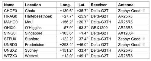
In consideration of the multitude of proposed applications for triple-frequency combinations, we took a close look at the quality of the new GPS L5 carrier-phase signal. For this purpose, we made use of measurements from the COoperative Network for GIOVE Observation (CONGO), jointly established by the German Federal Agency for Cartography and Geodesy (BKG) and the German Aerospace Center (DLR). CONGO is the first network of multi-constellation, multi-frequency GNSS receivers offering worldwide tracking of the SVN62 space vehicle on all frequencies (see Table 1).
Table 1. Subset of CONGO stations used for triple-frequency tracking of the new Block IIF satellite.
As suggested by Andrew Simsky (see Further Reading), the availability of carrier-phase measurements on three frequencies offers a particularly simple way to assess carrier-phase quality and multipath effects. By forming a linear combination
(1)
of the L1, L2, and L5 carrier-phase ranges with the additional conditions ,
a geometry- and ionosphere-free measurement is obtained, which reflects a weighted sum of the carrier-phase multipath and measurement noise on the individual frequencies. Here λ i with i = 1, 2, and 5, denotes the wavelength of the L1, L2, and L5 signals, respectively. Since the above conditions determine the factors α, β, and γ only up to an arbitrary scaling factor, we furthermore impose the normalizing conditions.
The latter condition ensures that the noise of the tri-carrier combination will match that of the individual carrier phases if the measurement noise is equal on all frequencies. As a result, we obtain the coefficients
with .
Introducing the carrier wavelengths of the L1, L2, and L5 signals, the coefficients attain the values (2)
It can be recognized that the tri-carrier combination is dominated by the L2 and L5 signals due to the proximity of their respective frequencies. Noise and multipath errors of L2 and L5 measurements are thus most prominently seen in the resulting combination, whereas any L1 phase errors are strongly attenuated.
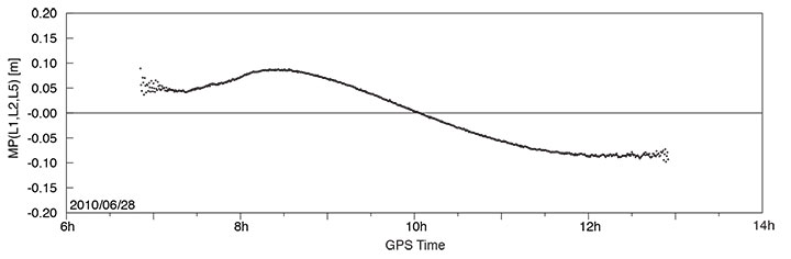
A long pass of L1, L2, and L5 code and phase measurements from the new Block IIF satellite was recorded by the O’Higgins station of the CONGO network shortly after the activation of the L5 signal generator on June 28. The SVN62 satellite was tracked for more than 6 hours and achieved a peak elevation angle of more than 75° on this date.
Figure 1 shows the resulting multipath combination computed from carrier-phase measurements of L1 C/A-code tracking, semi-codeless L2 P(Y) tracking (rather than L2C), and L5 I/Q tracking. The data have been leveled to a zero mean over the entire pass to remove the impact of the unknown carrier-phase ambiguities. Except at low elevation angles, near rise and set of the satellite where signal strengths are low, the tri-carrier combination shows a very low noise level that is consistent with the expected carrier-phase noise on all three frequencies. However, a pronounced long-term variation with a peak-to-peak amplitude of almost 20 centimeters may be recognized, which certainly comes as a big surprise and cannot be explained by local multipath. Frequency-dependent differences of the effective phase centers of the receiving or transmitting antennas can likewise be excluded, since these would result in a purely elevation-angle-dependent variation.
FIGURE 1. Triple-frequency (M=0.142·L1-0.767·L2+0.626·L5) carrier-phase multipath combination for SVN62/PRN25 tracking from the OHIX0 station on June 28.
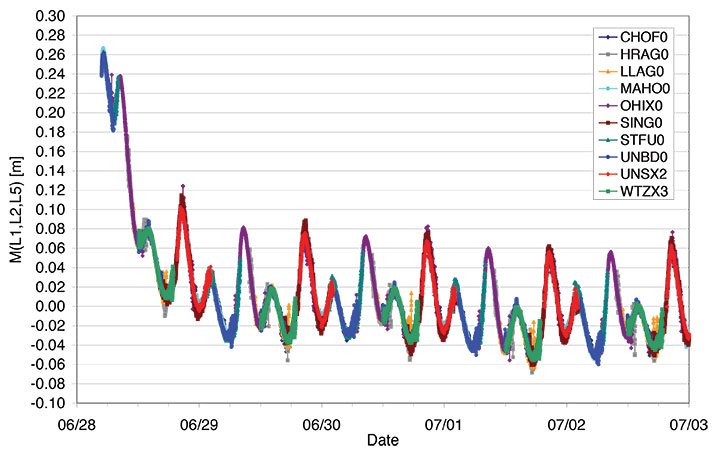
Looking at the entire set of measurements from all available CONGO stations, we could rapidly recognize that the variation of the tri-carrier combination with time is essentially the same for all stations with a common visibility of the SVN62 space vehicle, irrespective of the employed receiver and antenna. This suggests the presence of time-varying inter-frequency biases in the L1, L2, and L5 carriers transmitted by SVN62.
Thanks to the global distribution of the CONGO stations, the SVN62 space vehicle is always tracked by one or more stations, which enables a continuous monitoring of the L1/L2/L5 carrier-phase consistency. By adjusting the unknown offset of the tri-carrier combination for individual tracking arcs in such a way as to obtain a best match of consecutive and overlapping arcs, the variation can be traced over multiple days as shown in Figure 2. The graph shows a distinct orbital (that is, 12-hour) periodicity with a superimposed twice-per-revolution harmonic. In addition, a pronounced drift can be recognized for up to one day after activation of the L5 signal generator. Both observations suggest a temperature-dependent line bias in one or more carriers as a likely cause of the observed variation in the tri-carrier combination. (A line bias is a circuitry delay common in all observed satellites and is usually absorbed in the estimated clock offset.) However, an independent analysis of SVN62 temperature data from the onboard telemetry will be required to confirm the validity of this assumption. The space vehicle is in a deep eclipse orbit right now and therefore experiences substantial changes in its thermal conditions. However, the extreme points of the carrier-phase variation in Figure 2 are slightly shifted with respect to the local space vehicle noon (at 01:30 and 13:30 UTC) and the eclipse intervals (07:00–08:00 and 19:00–20:00 UTC).
FIGURE 2. Triple-frequency carrier-phase combination (M=0.142·L1-0.767·L2+0.626·L5) for the first five days of L5 activation on SVN62. The curve has arbitrarily been shifted to obtain a near-zero mean during the final days of the entire arc.
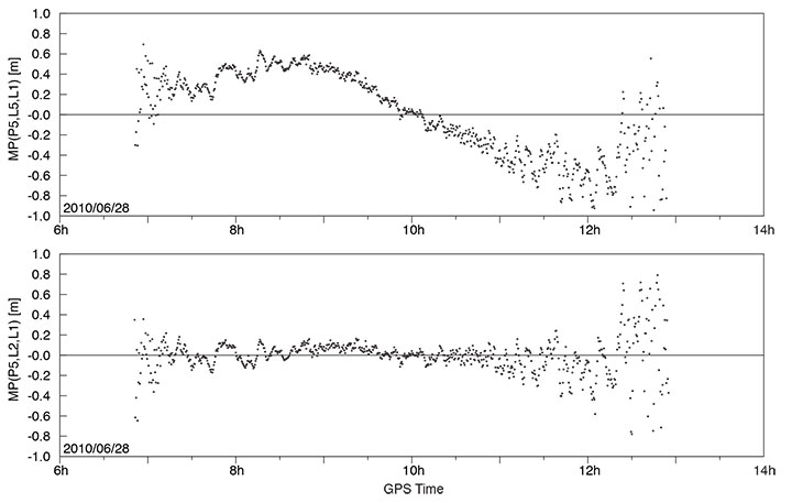
While the tri-carrier combination provides a very sensitive measurement for the analysis of differential delays between the individual carriers, it does not allow us to uniquely attribute the observed variations to one of the three signals. We therefore made use of code measurements (pseudoranges) to further investigate the consistency of specific sets of measurements. Since the observed variation of the tri-carrier combination exhibits an amplitude comparable to the noise level of the code measurements, a suitably chosen code-carrier combination can indeed help to identify which signal or signals are affected by line-bias variations. To this end, we consider a generalized form
of the well-known code-multipath combination, in which we difference the code measurement Pi at frequency i with an ionosphere-corrected combination of carrier-phase ranges Lj and Lk at frequencies j and k. In so doing, we remove geometric contributions along with clock and atmospheric variations, leaving primarily code multipath, receiver noise, and any signal perturbation that is not coherent on the involved frequencies. In the traditional case of dual-frequency tracking, the frequency of one of the involved carrier-phase measurements is necessarily identical to that of the code measurements. With triple-frequency tracking, in contrast, we are free to consider a larger variety of combinations. For the analysis of the SVN62 signals, we have specifically evaluated the L5 code-multipath combination using (a) the L5 and L1 carrier phases
and (b) the L2 and L1 carrier-phase measurements
The results shown in FIGURE 3 reveal a dramatic difference, which clearly hints at the L5 carrier as the main source of the observed carrier-phase variations.
FIGURE 3. L5 code-multipath combination formed with L1/L5 carrier-phase measurements (top) and with L1/L2 carrier-phase measurements (bottom). The figure is based on SVN62 tracking from the O’Higgins station and covers the same arc as considered in FIGURE 1.
In the first case, a variation close to that of Figure 1 is obtained, albeit with a 5–6 times larger amplitude that reflects the different weighting of the L5 carrier phase in the corresponding measurement combinations. A good consistency, in contrast, is obtained for the L5 code measurements when differenced against the ionosphere-corrected combination of L1 and L2 carrier-phase measurements.
Overall, we may conclude that the L5 carrier of the SVN62 space vehicle exhibits quasi-periodic line-bias variations with an amplitude of about 10 centimeters in relation to the L1 and L2 carriers. The L5 code measurements, in contrast, appear to be consistent with both the code and phase measurements on L1 and L2 at the respective noise levels. Further observations at a later time will be required to see whether the observed amplitude of the L5 phase variation is specific to the current eclipse orbit and whether it will possibly become lower when a higher angle of the Sun with respect to the orbital plane (the so-called beta-angle) is achieved.
What are the possible consequences of the L5 phase-bias variations for users of the new L5 signal? Evidently, new positioning services building on the L5 code measurements (and possible combinations) will not at all be affected! Even in the case of carrier-phase smoothing, the smoothing time scale will be much shorter than the periodicity of the carrier-phase bias variation. The L5 code measurement quality itself is well within the system specification and no concerns exist that would prevent the satellite from soon being declared healthy.
With respect to carrier-phase-based positioning applications, it is important to note that the L5 line bias acts like an additional frequency-specific satellite-clock offset. This has, for example, been confirmed in preliminary tests of SVN62 orbit determination conducted by the Technische Universität München. Orbit solutions using L1 and L5 measurements from the CONGO network differed by typically 15 centimeters (3D root-mean-square error) from reference orbits obtained by the Center for Orbit Determination in Europe analysis center using the IGS L1/L2 receiver network. At the same time, however, the L1/L5-based clock solutions showed a periodic offset from the L1/L2-based values that reflects the same variations as the tri-carrier combination discussed above.
As a common error for all receivers, the L5 line bias fully cancels in differential processing. Care must be taken though, that satellite clock offsets derived from L1/L2 carrier-phase observations cannot be employed for precise point positioning using L1/L5 measurements without explicit consideration of the inter-frequency carrier-phase bias. Likewise, efforts to correct second order ionospheric effects through the use of triple-frequency measurements are likely to suffer from an imperfect knowledge of the L5 bias and its variation with time.
Whereas some of the proposed ideas for triple-frequency processing may be difficult to materialize at present, a better characterization of the SVN62 L5 signal will certainly help to exploit the available benefits of the new signal and to establish refined processing schemes for scientific and other demanding applications. A continued monitoring of the L5 line bias and its variation with time is therefore deemed necessary and should be supported by a large number of suitably equipped tri-band GNSS monitoring stations.
— Oliver Montenbruck, Andre Hauschild (DLR/German Space Operations Center), Peter Steigenberger (Technische Universität München)
Richard B. Langley (University of New Brunswick)
Acknowledgment
The authors are grateful to Tom Stansell and Col. David Goldstein from the GPS Wing for early discussions and their independent assessment and interpretation of the SVN62 triple-frequency carrier-phase data.
Equipment
The CONGO network makes use of JavadTriumph Delta-G2T/G3TH and LeicaGRX1200+GNSS GNSS receivers for tracking GPS signals on the L1, L2, and L5 frequencies. The stations are equipped with TrimbleZephyr Geodetic II or LeicaAX1203+GNSS and AR25R3 antennas.
Further Reading
“The WAAS L5 Signal: An Assessment of Its Behavior and Potential End Use,” by H. Rho and R.B. Langley in GPS World, Vol. 20, No. 5, May 2009, pp. 42–50.
“Using Multi-Frequency for GPS Positioning and Receiver Autonomous Integrity Monitoring” by Y.-H. Tsai, F.-R. Chang, W.-C. Yang, and C.-L. Ma in Proceedings of the 2004 IEEE International Conference on Control Applications, Taipei, Taiwan, September 2–4, 2004, pp. 205–210.
“Triple Frequency Ambiguity Resolution Using GPS/Galileo” by O. Julien, M.E. Cannon, P. Alves, and G. Lachapelle in European Journal of Navigation, Vol. 2, No. 2, May 2004, pp. 51–57.
“Three’s the Charm — Triple Frequency Combinations in Future GNSS” by A. Simsky in Inside GNSS, Vol. 1, No. 5, July/August 2006, pp. 38–41.
“Total Electron Content Monitoring Using Triple Frequency GNSS Data: A Three-Step Approach” by J. Spits and R. Warnant in Journal of Atmospheric and Solar-Terrestrial Physics, Vo. 70, No. 15, December 2008, pp. 1885–1893, doi:10.1016/j.jastp.2008.03.007.
It has long been accepted that we may reasonably expect any new technical device to have some growing pains. If you examine the history of the space program you will discover evidence of this. In the case of the first GPS IIF vehicle on orbit we do not have a 12,552-mile screwdriver. but we do have dedicated software and systems engineers at Boeing and in the U.S. Air Force that will solve the issues that crop up and eventually present the world with a stable PNT platform.
I bring this to your attention because researchers at the German Aerospace Center (DLR) say they have found a small variance in the L5 signal on IIF-1. The signal variation results in no more than a 5-centimeter error with a predictable periodicity of about six hours. While observing the IIF, DLR also reports that the signal appears to be “hot” or stronger than anticipated or advertised by about 1/2 db.
Initial reaction from the GPS Wing and Air Force experts at Schriever AFB is that the signal fluctuation appears to be temperature-related, as the periodicity correlates directly to the temperature extremes the satellite is experiencing at this time of year in its MEO orbit. It is being investigated as a matter of course during the standard checkout of the satellite, which will continue for about another four weeks according to the original checkout schedule.
The GPS Wing is confident that all the IIF signal specifications will be met by the time the satellite is set healthy in about a month’s time and they will be able to move forward with the IIF launch schedule as planned. Obviously this could be perturbated by having to make corrections or adjustments to the satellites still to be launched, but this is normal procedure, and some leeway to correct anomalies is built into the schedule for the first few launches of any new satellite system.
Privately, one official commented, “It turns out that no one has ever made this measurement before. The Galileo SVs can only broadcast from 2 transmitters at a time so they are combining two E5 signals generated from the same transmitter. Furthermore, their data was collected during max Beta meaning when they weren’t in eclipse (less thermal variance).”
The press release from the GPS Wing reads as follows.
SMC Update. July 19 — “Officials from the Air Force Space Command, Space and Missile Systems Center’s Global Positioning Systems Wing announced the “on-orbit checkout” of the first IIF satellite is progressing as scheduled. “Nearing the half way point of its 90-day checkout period, GPS IIF SV-1 also known as SVN 62/PRN 25, is currently broadcasting the same L1 and L2 signals as previous GPS satellites and the new safety of life signal known as L5. All three signals being broadcast from SVN 62 are set unhealthy while experts monitor the quality and characteristics of the signals and the performance of the satellite.
“During the initial phase of testing, [DLR] combined L1, L2, and L5 signals in a technique used to characterize a number of known and modeled error sources from the signals. This three-frequency combining technique helps isolate “other” sources of location error, such as multi-path (when more than one path exists for signals to travel before reception), receiver errors, satellite induced errors and unmodeled phenomena. The L1, L2 and L5 signals from SVN-62 are operating nominally but DLR noticed higher residual errors than expected compared to previous somewhat similar measurements from Galileo’s GIOVE-A R&D satellite.
“The GPS Wing at Los Angeles Air Force Base has corroborated DLR’s results and is investigating root cause to share a deeper understanding of this new signal’s behavior with the user community. The causes of the phase variation are still being investigated, but they are likely the result of sensitivities to changes in the satellite’s thermal environment. SVN 62/PRN 25 is currently experiencing periods of both sunlight and total darkness (known as eclipse season) as the satellite orbits the Earth and traverses through Earth’s shadow. Tests to characterize the satellite’s performance during continuous sunlight exposure will continue after the current eclipse season ends later this month.
“Typical GPS receivers using stand-alone (single signal – L1, L2 or L5) or combinations of L1, L2 and L5 signals as part of their navigation solution will not be affected by this small phenomenon. The Air Force is committed to maintaining excellence in GPS navigation and timing services and to working with the user community to best use and exploit the new modernized GPS signals.
“When tests of this new generation of GPS satellites have been completed and Air Force leadership gives approval, the satellite signals will be set healthy and will operate as specified in the Interface Control Documents (ICDs).”