This month’s professional OEM newsletter by Rob Lorimer is about the use of GPS and other positioning technologies in open-pit mining and compliments a GPS World webinar on this subject scheduled for 1 p.m. PST May 20. The article also appeared in the August 2010 issue of GPS World magazine with a sidebar by Geoff Roberts of Leica Geosystems (see below).
By Rob Lorimer
Open-pit mining (also called open-cut, open-cast, and strip mining) has historically been an early and innovative adopter of new positioning technologies. Some of the earliest examples of fitting GPS to heavy earth-moving machinery occurred in the U.S., Australian, and Canadian mining industries in the 1990s. Miners were also quick to adopt the first GPS/GLONASS systems. The trend continues today with trials of new radio positioning technologies such as the Novariant Terralite XPS and the Locata system.
Phase 2 of a global mining boom is underway, driven by an apparently insatiable appetite for primary resources from developing economies such as China and India. Indeed, according to one study by Access Economics, to meet projected demand the production of some commodities such as nickel and zinc will need to double in the period 2000-2020; others, including coal and iron ore, will need to increase by 40-60% over the same period.
The response from the mining industry is two-fold. First, increase the productivity of existing mines; second, explore and develop new mining territories. Both these responses increase the demand for positioning systems, but we will focus here on first response.
Increased Productivity. Increasing the productivity of existing mines can take several forms, including extending the life of the mine and extracting the commodity more effectively. The former is generally driven by higher commodity prices (previously marginal deposits become viable); the latter is driven by adopting improved practices and new technologies, including those incorporating positioning components.
Productivity gains from new technology are multiplied by the scale of the mining operation, so it is no surprise that the largest mines were the first to experiment with and adopt new position-based systems, particularly in earth moving and commodity handling. The scope for productivity improvement is huge — there are more than 100 open-pit mines that move more than 1 million tonnes of material per week, about half of which are in Australia, Canada, and the U.S. Another 600-700 open-pit mines worldwide move between 10-50 million tonnes/annum, and a further 1,500 or so move 1-10 million tonnes/annum. On top of these there are tens of thousands of smaller mines and quarries, although to date most of these do not use innovative practices or technologies.
Just as new practices were usually adopted first in the super-mines and then progressivity smaller operations, there was a similar trend to apply new positioning-based solutions first to the largest earth-moving machines and then to progressively smaller machines and vehicles. As this process unfolded during the 1990s and 2000s, a number of companies emerged as global technology suppliers for mining, including the Caterpillar/Trimble Joint venture, Modular Mining (owned by Komatsu), and Leica Geosystems. However, there remains a vibrant small- to medium-enterprise (SME) positioning-based solutions sector in mining, most of which is focused on technology niches (for example, Novariant, APS, and Accumine.
Collision Avoidance. As positioning-based solutions progressively made their way onto heavy machinery (such as draglines, excavators, and dozers), and haul trucks and auxiliary equipment (drills and explosives trucks) for production purposes, another set of suppliers were eying up positioning technologies for a different reason.
As mines increase production from existing operations, site traffic increases and so does the risk of collisions. Of particular concern are collisions between heavy and light vehicles, which have a high probability of serious injury or fatality. There are many safety issues to be addressed: mining machinery and haul trucks have extensive operator blind spots, haul roads are unsealed and need constant maintenance, blind corners are common and intersections change frequently. Add to these issues 24-hour working, driver fatigue, frequent poor visibility caused by dust or snow, and the requirements for safety systems becomes apparent. The second wave of suppliers adopted GPS, RFID, lasers, radar, and other technologies to develop a range of driver adherence, situational awareness, proximity detection, and collision avoidance systems. These companies include Caterpillar, SafeMine, AMT, 3DP, and others (see the Professional OEM newsletter from July 2009 for a fuller discussion on GPS-based safety systems in mining).
When we add together the positioning requirements for both production and safety systems, we start to get a feel for the variety of positioning solutions applied on large open-pit mines today as illustrated by the table below. Indeed, on some of the most advanced mines virtually everything that moves, or can be moved, is fitted with some sort of positioning device for production, operational, logistics, or safety reasons.
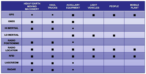
As the table illustrates, despite its limitations in deep open-pit mines, GPS remains a popular choice for positioning and can be found on most platforms from people to heavy machinery. GPS/GLONASS (GNSS) receivers have largely replaced GPS-only receivers for heavy machinery, haul trucks, and auxiliary equipment (such as drills) as it delivers improved availability over GPS. However, the cost of GNSS receivers has meant they are not as popular on the more numerous light vehicle fleets. With low-cost GNSS chipsets coming on the market, we can expect this situation to change quickly over the coming years.
Both high-end (HI Inertial) and low-cost (LO Inertial) technology are deployed in open-pit mining, usually in conjunction with GPS or GNSS. High-end inertial systems tend to be in machine control systems; the low-cost devices, including electromagnetic compasses and accelerometers, are more often used in vehicle and personal safety devices.
In the table above, I have distinguished between radio positioning and radio location technologies. The former are dedicated positioning systems such as the Novariant Terralite and Locata, which deliver precise positioning from planned networks of transponders on site. The latter derive location from communications systems, and are generally accurate to a few meters (for example, the 3DP systems built on a Motorola Motomesh backbone).
Radio Frequency Identification (RFID) location is well established in the mining industry for both underground and open-pit operations. Although not used for high-precision machine control applications, RFID can be found on all platform classes for safety, operational, and logistics purposes.
Both Electronic Distance Measuring (EDM) and laser technology are used to position machines and haul trucks. As these are line-of-sight systems, they tend to be deployed in close proximity to work areas. Laser technology is used with roadside beacons to locate and navigate trucks along haul roads.
Finally, radar is used in several safety systems for proximity detection and collision avoidance, but can also be used with roadside beacons for navigation and location.
Positioning Mix. The reali
ty is no single technology has the right mix of precision, availability, and cost to meet all the production, operational, logistical, and safety applications within open-pit mining today. System integrators are experimenting with different combinations, with many claims and counter claims about which mix is superior. What may well be a deciding factor for success is which positioning technologies (or technology combinations) are scalable to non-mining applications; that’s where GPS, GNSS, and RFID have a distinct advantage today.
To learn more about positioning technology in mining, including a more detailed look at one of the new radio positioning technologies, tune into my webinar at 1 p.m. PST May 20, or download it post event.
Digging for Accuracy
By Geoff Roberts, Leica Geosystems
A reality of open-pit mining is the challenge of GPS positioning coverage as the mine is cut deeper into the earth, and with the price of minerals rising, miners are digging deeper than ever before. Reduced sky view to satellites, especially where machinery is working near pit walls, can cause signals to become obstructed. With high-precision machine-control systems heavily utilized on mining equipment, a loss of positioning signal affects mine productivity. For years, Leica Geosystems has addressed sky-view issues by offering hybrid positioning for its high-precision mining machine control systems, using GPS and GNSS signals. While this has seen great advantages, GPS and GNSS share the same weakness as the pit is cut deeper or when operating against a high wall.
Recent developments aimed at making systems less dependent on satellite signals has resulted in the successful integration of a “local positioning constellation,” through technology developed by Locata Corporation. LocataLites are positioned around the rim of the pit and transmit to machinery-mounted receivers integrated into Leica Geosystems’ high-precision machine-control system, acting as local satellites with the advantage of being visible to machine-control systems, independent of GPS/GNSS coverage.
With this integration, blast-hole drills, dozers, and shovels can continue operating to centimeter accuracy when GPS/GNSS is unavailable. LocataLites self survey using GPS at the surface level where coverage is trouble free, and can easily be moved around a site to cover holes in coverage. Locata positioning becomes more accurate as the pit is dug deeper due to gaining sufficient vertical geometry for 3D positioning, a great advantage as the pit grows down. Rigorous testing of Leica Geosystems’ Locata integrated system has been conducted at one of Australia’s largest mines over the last six months. Results have proven reliable and accurate, while delivering significant productivity gains through reduced downtime caused by GPS/GNSS coverage holes.