The European Space Agency (ESA), in collaboration with the Joint Research Centre of the European Commission, are hosting this year’s ESA/JRC International Summer School on GNSS with the Swedish Space Agency in July in Kiruna, Sweden. The course will include an overview of satellite navigation from the theoretical basis of GNSS, their signals, and processing by receivers and more.
Elements of this year’s program will include details of low-Earth-orbit positioning, navigation and timing, navigation on the Moon, and Galileo’s Open Service Navigation Message Authentication. Exercises will include receiving signals from Galileo and other GNSS.
Participants will also learn about business aspects, intellectual property rights, and the future of satellite navigation systems, including Galileo second-generation.
Some of the world’s leading satnav and space experts will be giving lectures. Lecturers include Paul Verhoef, former director of navigation for ESA, and Jean-Jacques Dordain, former director general. The course will be opened by Anna Rathsman, Director General of the Swedish National Space Agency; Javier Benedicto, Director of Navigation at the European Space Agency; and Georgios Giannopoulos, head of the Technologies for Space, Security and Connectivity Unit at the Joint Research Centre of the European Commission.
The course is limited to 50 participants on a first-come, first-served basis and is open to graduate students, Ph.D. and postdoctoral researchers, as well as young engineers and academics working within industry or agencies, aged 38 or younger.
The summer school will take place July 17-28 in Kiruna, Sweden. Register before April 14 for a reduced early fee. For more information and to register, click here.
The European Space Agency (ESA) is in search of European companies interested in taking part in the in-orbit demonstration of a low-Earth-orbit (LEO) satellite navigation constellation utilizing novel frequencies and capabilities.
Those interested in participating are encouraged to attend ESA’s LEO-PNT Industry Day on March 7 at the ESTEC technical center in the Netherlands. The LEO-PNT Industry Day will give an overview of the project to companies, research institutions and ESA delegates from Member States.
A detailed invitation will be issued soon, covering all aspects of the LEO-PNT Orbit Demonstrator, including the space and ground segments, operations, launchers, the test user segment, experimentation, and segment demonstration.
Registration by Feb. 27 is required. To learn more, visit atpi.eventsair.com.
LEO satellites would supplement the existing Galileo constellation. (Image: ESA)
What are your thoughts on the “geodesy crisis” and what do you propose to address it?
Bernard Gruber
“Evidence seems to be very clear that we, as a country, need geodesists and that there has been a decline in investments, training, and research in geodesy. While our decline relative to China may be shocking, it should not be surprising. U.S. industry and government relentlessly pursues STEM graduates, or those with relevant experience, but that does not meet current needs. Besides maybe surveying, it is unclear to the public what the geodesy profession is all about, why it is needed, and quite frankly, why it is an exciting career choice.”
— Bernard Gruber Northrop Grumman
Does crowding of low-Earth-orbit (LEO) space — with new satellites and space debris — pose any problems for the launch or operations of GNSS satellites in medium Earth orbit (MEO)?
Ellen Hall
“This was a focused topic at SATELLITE 2022, where the discussion centered on the 6,000 tons of space debris circulating in LEO. Even the smallest piece of debris can be lethal to a satellite, so the key is to track and maneuver where possible. Add to that about 5,000 active satellites and plans to launch tens of thousands of additional ones into LEO over the next few years, and you have a serious problem to overcome. While there are treaties and plans for tracking and maneuvering these satellites, the debris is the real challenge.”
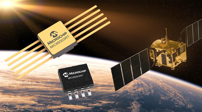
Microchip Technology has launched the MIC69303RT 3A Low-Dropout Voltage Regulator, a radiation-tolerant power management device for space application developers. This high-current, low-voltage device targets low-Earth orbit (LEO) space applications.
The MIC69303RT operates from a single low-voltage supply of 1.65 v to 5.5 v and can supply output voltages as low as 0.5 v at high currents. It offers high-precision and low dropout voltages of 500 mv under extreme conditions. The MIC69303RT is a companion power source solution for Microchip’s microcontrollers, such as the SAM71Q21RT and PolarFire field-programmable gate arrays.
This device is designed for harsh aerospace applications and remains operational in temperature ranges from -55 C to +125 C. It is offered in 8-pin and 10-pin package configurations with radiation tolerance up to 50 krad.
Additionally, the MIC69303RT is manufactured in compliance with MIL Class Q or Class V requirements, including screen testing, qualification testing and more.
The MIC69303RT is available for prototype sampling in both plastic and hermetic ceramic. The plastic MIC69303RT is compliant with high-reliability plastic quality flow derived from AEC-Q100 automotive requirements with specific additional tests necessary for space applications.
This device is available in limited sampling upon request.
New PNT satellites will operate in low Earth orbit (LEO). (Image: ESA)
News from the European Space Agency (ESA)
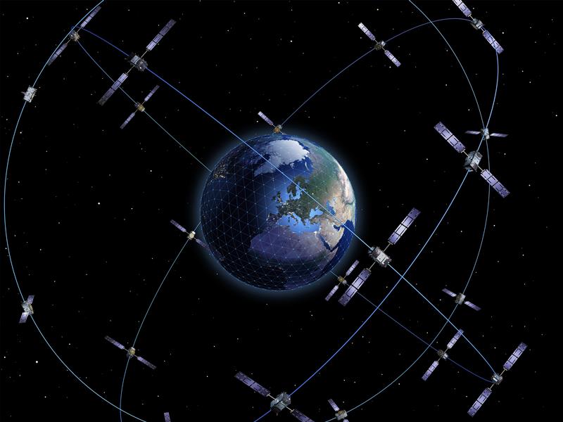
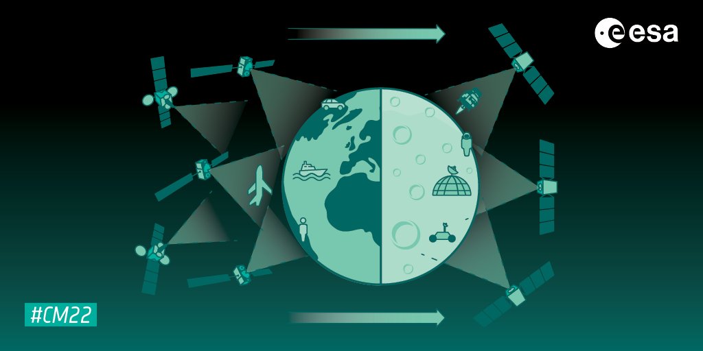
Satellite navigation is headed closer to users. ESA’s Navigation Directorate is planning an in-orbit demonstration with new navigation satellites that will orbit just a few hundred kilometers in space, supplementing Europe’s 23,222-km-distant Galileo satellites.
Operating added-value signals, these novel low-Earth-orbit (LEO) positioning, navigation and timing (PNT) satellites will investigate a new multi-layer satnav system-of-systems approach to deliver seamless PNT services that are much more accurate, robust and available everywhere.
Global in coverage, free for everyone to use, GNSS such as Europe’s Galileo have already transformed our society, and due to their sheer omnipresence their influence continues to grow. In 2021, the population of satnav receivers reached 6.5 billion around the world, and the sector is projected to maintain a 10% annual growth rate in the years ahead. But in various respects the standard GNSS approach is nearing the limits of optimum performance — to get even better, added ingredients are becoming essential.
“Satellite navigation has enabled a vast range of applications in recent years, but this very success is inspiring still more demanding user needs for the coming decade,” said Lionel Ries, head of ESA’s GNSS Evolutions R&D team, overseeing the agency’s LEO-PNT studies.
“For use cases such as autonomous vehicles, ships or drones, robotics, smart cities or the industrial internet of things for control of factory systems, the positioning requirements are growing from the current meter-scale to centimeter scale or even more precise, based on continuously reliable signals that are available anywhere, anytime — even indoors —while able to overcome interference or jamming.
“Up until now we have relied for positioning on the classical solution of GNSS such as Galileo, located in medium Earth orbit and based on L-band signals. Standard GNSS alone is not going to be able to fulfil all these future user demands. Instead Europe needs to seize the opportunity to investigate the potential of the kind of LEO constellations that are already on the way in the global market to enable new kinds of PNT services.”
Simply by virtue of physics, with less of a distance to cover down to Earth, the signals from these LEO-PNT satellites can be more powerful, able to overcome interference and reach places where today’s satnav signals cannot reach.
Additionally, by adopting novel navigation techniques and a wider range of signal bands the satellites can address particular user needs: for instance at lower orbits the satellites themselves move more rapidly relative to Earth’s surface — think of the International Space Station at 400 km that orbits the Earth every 90 minutes — which offers possible advantage in the time needed to reach very accurate positions. Also some bands could offer greater penetration in difficult environments while other bands could offer higher robustness and precision.
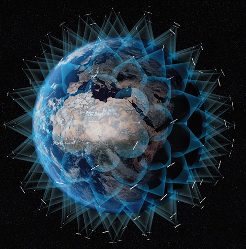
Mega-constellations of hundreds or even thousands of low-orbiting satellites offer a means of acquiring continuous coverage for telecommunications services or Earth observation. (Image: ESA)
The purpose of ESA’s plan to perform an in-orbit demonstration of low Earth orbiting satnav satellites is precisely to consolidate the types of signals, enabling technologies and their potential for future services.
The plan is to build and fly an initial mini-constellation of at least half a dozen satellites to test capabilities and key technologies, as well as demonstrating signals and frequency bands for use by a follow-on operational constellation, in the same way that Europe’s GIOVE test satellites paved the way for Galileo. Success will place European industry in pole positions for follow-on commercial undertakings, as well as planned institutional programs.
“Each individual satellite would be comparatively small, below 70 kg in mass, compared to a 700 kg current Galileo operational satellite,” added Roberto Prieto-Cerdeira, Galileo Second Generation satellite payload manager and LEO-PNT project preparation manager as part of ESA’s FutureNAV program.
“They can be comparatively more streamlined because they can benefit from other means to calculate the accurate time without extremely precise atomic clocks on board — including relayed signals from the Galileo satellites above them. These satellites would also be built on a rapid batch production basis to save time and cost — we are targeting three years at the most from signing the contracts to the first satellites in orbit, the same kind of timescale achieved by GIOVE-A in the early 2000s.”
A vision of the future shows layered satellite navigation stretching from Earth to the Moon. (Image: ESA)
“It is ESA’s ambition to ensure Europe maintains a world-class space industry, and navigation today forms the single largest downstream space sector, worth about €150 billion annually and growing at the rate of 10% per year,” said ESA Director of Navigation Javier Benedicto-Ruiz. “Standing still is not an option; instead we need to explore new technical avenues to spur European competitiveness and commercialization.”
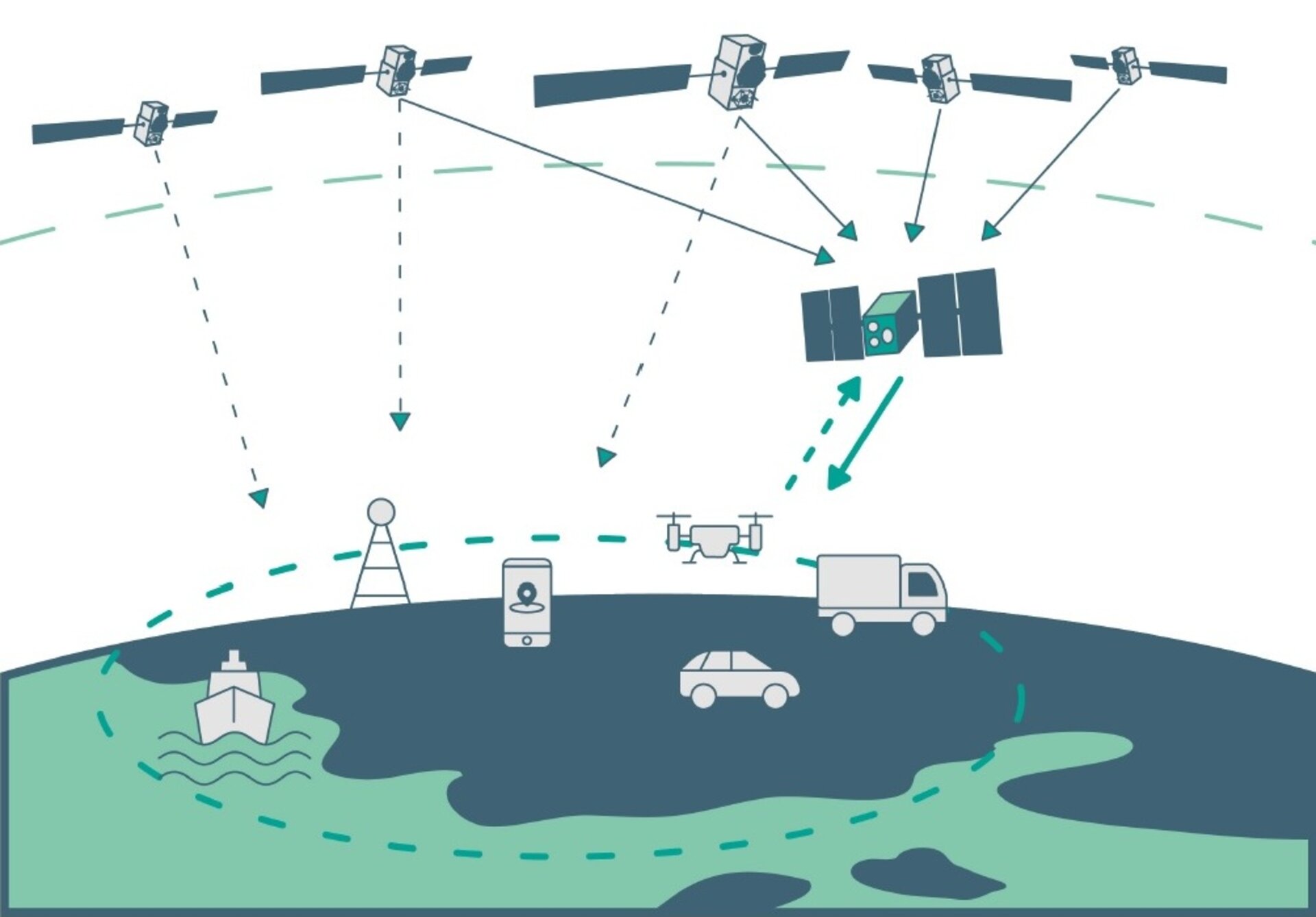
An operational version of the LEO-PNT constellation would represent a whole new layer for PNT delivery, combined with traditional GNSS as well as 5G/6G-based positioning on the ground, and fused with data from sensors in the user terminals.
Interest from industry
ESA has been researching core elements of the LEO-PNT concept since 2016. Now, with numerous low Earth orbit constellations already taking shape around the globe, the time is right to move from basic research to in-orbit demonstration.
Interest from European industry in the LEO-PNT project has been very high, shown by a recent Request for Information where ESA presented details of how companies and institutions might participate and a large number of companies registered and presented possible concepts and contributions.
Forward to FutureNAV
LEO-PNT is supported through the ESA Directorate of Navigation’s FutureNAV programme, which also includes the GENESIS satellite to measure the shape of Earth more accurately than ever before while also boosting the positioning performance of satnav satellites. The FutureNAV programme, which includes both GENESIS and the LEO-PNT initiative, is up for decision at ESA’s next Ministerial Conference, taking place in Paris on Nov. 22-23. Read the fact sheet here.
Until now, all navigation satellites have flown in medium-Earth orbit – up at 23,222 km in the case of Galileo, which delivers meter-level accuracy. At such altitudes the satellites move slowly across the sky, helping ensure global availability of satellite navigation signals, albeit at relatively low power.
ESA’s LEO PNT constellation would move to a “multilayer system of systems” approach, with medium-Earth orbit signals supplemented by those from LEO satellites at altitudes of less than 2,000 km — along with additional inputs from terrestrial PNT systems and user-based sensors, made up of approximately a dozen satellites, helping European companies move forward at a time when worldwide commercial interest is high in LEO constellations of all kinds, especially for telecommunications and PNT.
The satellites themselves can be stripped down compared to current navigation satellites, because they would essentially be relaying satnav signals from MEO. This is a key point because there will need to be many more satellites to ensure global coverage — because the lower the orbit the faster each individual satellite will pass across the sky. This fact also opens the way to a more agile “New Space” approach to satellite construction for European firms, with smaller payloads and simplified operations from the ground.
Their signals will be much stronger (potentially able to penetrate indoors), and transmitted on novel frequencies, which – along with the new geometries made possible by LEO satellites – should enhance overall service resilience. LEO PNT will also deliver faster position fixes and enable rapid two-way authentication checks. And overall signal availability will be boosted enormously, especially in high-latitude and polar regions.
Xona Space Systems, a company developing navigation technologies from low-Earth orbit (LEO), has received investment backing from numerous companies, including Lockheed Martin. Its latest financing round was oversubscribed, bringing the start-up’s total funding to more than $25 million.
Xona is developing a high-performance commercial satellite navigation network, named Pulsar. Pulsar is a LEO system designed to provide resilient and trusted centimeter-level position anywhere on the globe.
Within the past year, Xona more than doubled its number of full-time employees, launched its first orbital mission, and signed agreements with major players across the GPS/GNSS ecosystem such as Hexagon | NovAtel and Spirent Federal.
Image: Xona Space Systems
The funding round was led by First Spark Ventures, who is joined by numerous new investors including Lockheed Martin Ventures, SRI Ventures (of SRI International), Velvet Sea Ventures, Gaingels, Airstream Venture Partners and Space VC. Existing investors also continue to show firm conviction in Xona’s accomplishments and market opportunity with participation from Seraphim Space, Toyota Ventures, 1517 Fund, MaC Venture Capital and Stellar Ventures.
The new capital will accelerate development of Pulsar through several critical design milestones by expanding the team and building out Xona’s new R&D and manufacturing facility in Burlingame, California. This will enable more rapid design cycles and prepare for production.
Xona’s first demonstration mission, Huginn, was successfully launched in May, and its second mission, Muninn, is planned to launch in 2023.
Xona Engineer Nick Manglaviti setting up hardware-in-the-loop testing at Xona’s R&D lab in San Mateo, California. (Photo: Xona Space Systems)
“Xona’s approach to GNSS is poised to enable a whole new class of robust and reliable solutions in everything from automotive to drones,” said Manish Kothari, managing director of First Spark. “This is a technically challenging problem — a problem the Xona team is uniquely qualified and experienced to address. We are very excited to be part of this journey with them.”
Xona’s core mission is to enable modern technology to operate safely in any environment, anywhere on Earth. To achieve this in industries such as automotive autonomy, drones and aerial mobility, precise knowledge of location and time is critical, and it must be robust against sources of potential interference or degradation. This is driving a need for global infrastructure that can support the demands of these applications as they continue to expand in both capability and geography.
“The massive domain expertise of our supporters in everything from scaling global companies to deep technical knowledge of GNSS is both a validation of our team’s capabilities and a catalyst that has been instrumental in our growth and speed,” said Xona CEO Brian Manning.
“As customer needs evolve, Lockheed Martin Ventures continues to work with companies we believe are on the forefront of emerging technology and that support increasingly resilient, hybrid systems,” said Chris Moran, vice president and general manager of Lockheed Martin Ventures. “We invested in Xona so they can continue to develop and build their commercial system to complement the greater GNSS architecture.”
“The world would look very different today without GPS,” said Xona CTO Tyler Reid. “The ubiquitous robust precision that Pulsar can provide has potential to make the same level of global impact, not only in present and emerging markets, but we believe this global high precision can also enable entirely new devices and apps that we haven’t even thought of yet.”
Data shows how successful baseline validation testing of Spirent’s inertial simulation model as compared to real world inertial system performance. Photo: Spirent Federal Systems
We discussed complementary PNT with Roger Hart, head of engineering and Jeff Martin, head of sales at Spirent Federal.
What are some of the most promising approaches to complementary PNT sources and how does simulation technology help?
Roger Hart: The vulnerabilities of GNSS have been recognized. Legacy GNSS are all operating on pretty much the same frequencies and power levels, so, they have some significant common vulnerabilities. There is great interest in finding ways to complement or even replace those capabilities.
Dead reckoning, magnetic and inertial systems have been around for a long time. There are emerging markets to make use of alternative radio frequencies for navigation. In some cases, we are piggybacking on communications signals and deriving PNT from them. In other cases, we are using new PNT signals. A couple that we’ve been focusing on are the alternative navigation systems.
They may be using different orbits, different frequencies, different encoding schemes that set them apart from the legacy GNSS systems, so that, used together, they provide greater resiliency and even stand alone when one or the other system may be affected by interference.
Not to be forgotten is inertial navigation. It’s been around for a long time and is still a standard of navigation. Together with GNSS, it makes it a terrific navigation system. It almost defines complementarity because where GPS is vulnerable inertial can fill in the gaps and where inertial drifts GPS does not. So, paired, they make a very strong system.
At Spirent, we’ve been working with customers to provide a variety of options for both those alternative navigation systems and inertial. Both are a very active field of development and we’re keeping abreast of that.
Jeff Martin: Some good points, Roger. This is something we’ve been engaged in for quite a long time. Since we provide test equipment to the community, it’s critical that we understand what they’re worried about, what the vulnerabilities are. It keeps things exciting, it keeps us on our toes and looking ahead to what’s coming.
What are some of the remaining challenges of integrating GNSS receivers with inertial sensors and, again, how does simulation technology help with that?
Hart: Inertial works by integrating sensor measurements that come in. Therefore, any errors that are present just accumulate over time and can corrupt your navigation solution. So, there’s a strong focus on updating error models and on translating them so that everyday users can use them and get real-life-type performance out of them.
There’s a tendency to think of integrating GPS-INS as putting everything together in one box. There are packages that do that. However, the push now is to go to more distributed systems that are integrated but not packaged in the same box. One example is the all-source positioning and navigation standard that is being developed by the Department of Defense. It will allow you to swap one sensor for another as long as they adhere to the standard. That information all goes back to a sensor fusion engine.
Martin: We have known GNSS simulators well for about four decades. We have been playing in the inertial sandbox for at least a couple of decades as well. This has given us the opportunity to build relationships with the with the key manufacturers and designers of inertial systems. Those relationships have been expanding well beyond inertial to many other sensors and systems that are now coming online. It’s been exciting.
Much work is going into using low Earth orbit satellites for PNT—whether piggybacking on the Iridium satellites or launching new ones. How does simulation help with that?
Hart: It certainly helps with the development of the receivers. The groups that are using these alternative RF and LEO or MEO systems need simulation as they develop the receivers. It gives you the ability to try things certainly before you launch them. At this conference there is considerable interest in making things reprogrammable. We have the NTS-3 satellite, which will be running experiments for different waveforms that can be generated. Even M-code is a step in the direction of giving more flexibility to the signal. It has a lot more flexible cryptography and signal generation than the legacy system with the C/A and P/Y codes.
Our simulation platforms are software based, so we can generate and receive data that can be useful for developing software-defined receivers. It gives you the opportunity to try different waveforms. We have already delivered a satellite-based alternative navigation system simulator. Now, we can build on that one to help the other Leo constellations as they come forward.
Martin: Roger put it well. This is where things get fun. People are concerned with PNT vulnerabilities, so we’re seeing these alternative navigation solutions coming forward. Spirent has done a good job over its nearly 40 years of existence of manufacturing and designing its own hardware and software. It has given us the opportunity to respond quickly. These things are coming fast. People need solutions quickly. We have some solutions already and the platform that we have created gives us the flexibility to develop more. We’re seeing more and more ideas come to fruition and people need to test them. So, this is where it gets fun. We’re excited.
Much work has gone into addressing the enduring challenge of urban canyons. How does simulation technology help?
Hart: Urban canyons are the worst nightmare for GNSS signals. If you’re surrounded by tall buildings, signals are blocked. You may have few or even no satellites in a direct line of sight and many multipath reflections. So, diminished and corrupted signals are available to you. Of course, the more GNSS satellites you have, the better chance you have of getting good signals. But complementing that are radar and vision systems. Those are the ones that will stand out, particularly the vision systems that can read the street signs, see where the curb is, look for parked cars. All those kinds of things will help fill in when you have poor GNSS coverage.
You can observe what’s going on in the environment and simulate it. You can also use our forecasting tool to look ahead.
Martin: This is where things get exciting, isn’t it? In these terrible environments where GNSS is contested—whether it’s an urban environment or one with intentional jamming—there is a lot we can do to help our industry. When this happens in real life, it’s bad news. But when you create that scary situation in the controlled environment of a laboratory, it is great. You can pick things apart and see where you need to improve. I get excited about it. It’s probably the geek in me. It gives us and our partners a lot to look forward to.
How does simulation technology help with sensor fusion?
Hart: It definitely helps you put all the pieces together. You can’t know how your system will work by individually testing each piece. System is the key word here. Simulation enables you to generate the signals and bring them together into a sensor fusion engine. You can test different algorithms. It’s certainly much cheaper and quicker than trying to build this into a product and then test it. Over the decades, simulation has proved itself as a very valuable way in both basic development and integrating the final product.
Martin: That system-wide fusion is where the magic happens.
It sounds like simulation technology—and Spirent Federal in particular—are very much at the center of a lot of the current developments and discussions about complementary PNT. Do you have any final comments?
Hart: As Jeff said, it’s an exciting time. There are many things going on—new technologies, new ways of communicating. It’s a busy time and a bit of a scramble sometimes to keep up with all the new things that are coming.
Martin: People look to Spirent to be their testing resource and it puts us right in the middle of it.
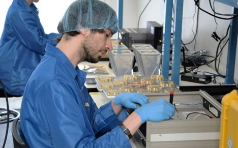
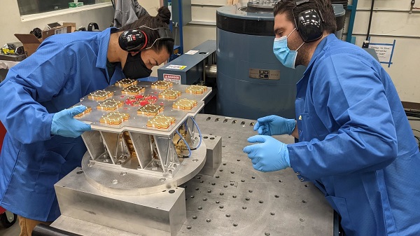
Xona has completed environmental testing for its upcoming demo mission, a significant step towards realizing its high-performance commercial navigation system
Xona Space Systems announced that their first in-space demonstrator has been delivered to Spaceflight Inc. for final integration after successfully completing testing and is scheduled for launch on SpaceX’s Transporter 5 in May.
Xona is an aerospace startup developing a precision navigation and timing system in low Earth orbit. It plans to build an independent high-performance satellite navigation and timing system to meet the needs of intelligent systems.
Xona’s first demonstration mission successfully completed testing at Experior Laboratories and prepares for launch on a Falcon 9 in May. (Photo: Xona)
Satellite navigation systems such as GPS and Galileo are in the domain of major governments (and free to users). Xona said it is part of the new commercialized space movement, using it to bring benefits to satellite navigation and timing.
Xona Space is launching Huginn, the first of two missions, demonstrating the capability of its Pulsar constellation. Pulsar’s architecture uses small, powerful satellites in low Earth orbit, more than 20 times closer to Earth than GPS satellites, which are in medium Earth orbit.
Pulsar is planned to deliver high-performance navigation and timing services by combining security and signal designs with Xona’s patent-pending distributed atomic-clock architecture to enable robust precision navigation services from low-cost satellites. Its precision LEO positioning, navigation and timing (PNT) service leverages advances in small satellite technology to provide users with a secure and robust alternative to traditional GNSS.
Xona’s system architecture utilizes the efficiency of small satellites to provide an affordable global system with more than 10 times better accuracy and 100 times better interference mitigation than legacy systems, the company claimed
Huginn will transmit the first precision navigation signals from a LEO spacecraft, designed to test and validate the core software and hardware technology that Xona has developed for Pulsar. The mission will also demonstrate the functionality of end-user equipment on Earth and supporting ground systems.
Huginn is now going through final integration with Spaceflight in preparation for launch on the scheduled Transporter 5 mission in May.
“We’re thrilled that Huginn has successfully completed its very rigorous test campaign in preparation for launch and are incredibly proud of the Xona team for achieving such a critical milestone,” said Brian Manning, CEO of Xona. “Through this process, we learned a massive amount and will be incorporating these lessons into our second demo mission as well as the production satellites.”
Following the Launch of Huginn, the Xona team will shift focus to the second demonstration mission as well as the development of the Block I Pulsar system.
The final Pulsar constellation will consist of several hundred LEO satellites, delivering secure and robust precision PNT services designed to meet the needs of advanced applications such as self-driving cars, precision agriculture and construction, augmented reality, critical infrastructure, and many others.
“It is inspiring to see what this team has been able to achieve going from a blank slate to orbit in less than a year from the time we completed our ground-based prototype testing,” Manning said. “This is a huge step in the development and deployment of our Pulsar constellation, and we’re looking forward to a very exciting year here at Xona.”
Xona is backed by Seraphim Space Investment Trust (LSE:SSIT) and MaC Venture Capital, with participation from Toyota Ventures, Daniel Ammann (co-founder of u-blox), and Ryan Johnson (former CEO of BlackBridge, operator of the Rapideye constellation). Follow-on investors also include 1517 Fund and Stellar Solutions.
Xona Space Systems fully funded for first LEO satellite navigation mission
Xona Space Systems is preparing for the launch of its first commercial positioning, navigation and timing (PNT) satellite, the first in a planned 300-satellite low-Earth orbit (LEO) constellation designed to cover the globe.
Xona has raised a new funding round co-led by Seraphim Space Investment Trust and MaC Venture Capital, with participation from Toyota Ventures, Daniel Ammann (co-founder of u-blox), and Ryan Johnson (former CEO of BlackBridge, operator of the Rapideye constellation). Follow-on investors also include 1517 Fund and Stellar Solutions.
Xona’s Pulsar precision LEO positioning, navigation and timing (PNT) service leverages advances in small satellite technology to provide users with a secure and robust alternative to traditional GNSS. The satellites will orbit 25 times closer to Earth than GPS satellites do.
Xona’s patent-pending system architecture makes use of the efficiency of small satellites to provide an affordable global service with 10 times better accuracy and 100 times better interference mitigation than the legacy systems, the company claims.
“We view global coverage of a safe, secure, and highly accurate navigation service as critical to the future of autonomy and countless other markets,” said Jeff Crusey, investment director of Seraphim Space Investment Trust. “We’re excited to continue supporting Xona because they’re an extremely talented and uniquely positioned team to execute on this plan.”
The funds raised this round will support the completion of Xona’s first orbital mission, scheduled for mid-2022, to demonstrate the capabilities of their Pulsar precision LEO PNT service.
Xona successfully tested its navigation system during a ground-based demonstration earlier this year, marking a major milestone for the company. It is now expanding laboratory facilities to support further development and enable on-site testing and manufacturing. This funding round will also provide for the growth of Xona’s technical team, which includes space and GNSS experts previously from NASA, Lockheed Martin, Maxar, L3 Harris, Blue Origin and SpaceX.
“Knowledge of location and time is one of the most fundamental aspects of both human life and machine operation,” said Brian Manning, CEO of Xona. “GNSS creates trillions of dollars of value by accurately answering the questions of ‘where am I?’ and ‘what time is it?’ for users all around the world. Xona was founded around the mission of enabling modern technology to operate safely in any environment, anywhere on Earth. To achieve this for both humans and machines, a foundation of reliable and accurate PNT is an absolute necessity, which is exactly what we are working to provide at Xona.”
19% of tracked space objects threaten GPS and other GNSS satellites. While there are many fewer objects in MEO than in LEO, the risk in the former is arguably greater because GPS is so critical to almost all of our technology.
The Risk
GNSS satellites, especially GPS satellites, are critical to the well-being and smooth functioning of economies and national security. This is especially true in Europe and the United States, which do not have complementary terrestrial systems able to provide vital positioning, navigation and timing (PNT) services when signals from space are not available.
While the probability of debris damage to GNSS in medium Earth orbit (MEO) is much less than for satellites in low Earth orbit (LEO), the consequences of such an event would be much, much higher. The loss of one satellite would be a concern; that of multiple satellites, a major problem. The unthinkable chaos, national security damage, and severe economic impacts to the $21 trillion U.S. GDP make the risk unacceptable.
For those who think we need not worry about the low probability of collisions at MEO, the Galileo collision avoidance maneuver in March 2021 should be a wakeup call. The problem is here. We need to act now.
Background
Much like a nuclear fission reaction, the problem of space debris starts small then grows exponentially, as each collision creates more pieces that, in turn, can collide with other objects.
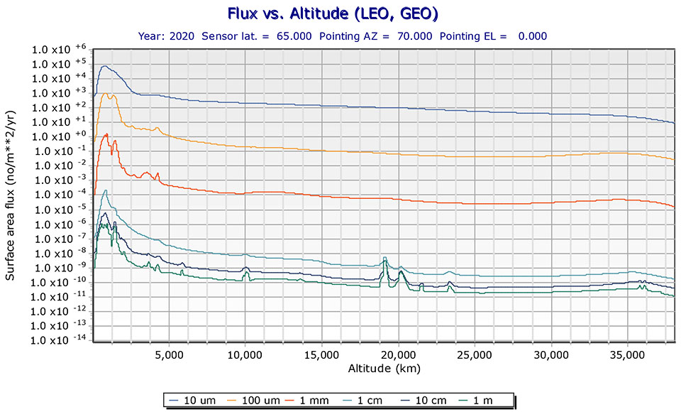
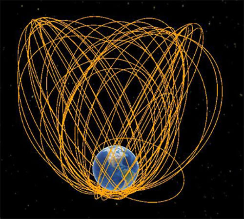
The MEO debris environment is 100 times less dense than the LEO. The spatial density of orbital debris in LEO (up to 2,000 km), shown in Figure 1, suggests that LEO is the likely location where a runaway chain reaction will initiate. This could easily result in a region of space so dangerous that it would effectively deny access to MEO, where the GPS constellation resides.
While the debris situation at MEO is much better, there are still 4,021 tracked debris objects that could impact GPS and other GNSS satellites. Because future orbital debris collisions in LEO will be responsible for more debris in MEO, the situation is guaranteed to get worse. The dead and debris objects in highly elliptical, or Molniya, orbits, shown in Figure 2, could be responsible for such collisions pushing LEO debris into MEO.
Contributions to the general MEO debris population come from launch systems and other factors. Early GPS satellites (Block II/IIA/IIR) used internal orbital-insertion motors to avoid leaving uncontrolled stages in the operational orbit range when moving from transfer orbit to MEO. For survivability reasons, they were also deployed with sufficient fuel to make several major orbital moves. Unfortunately, later versions used separate orbital-insertion stages, which were left drifting in the orbital neighborhood and carried less fuel, resulting in fewer possible maneuvers to avoid collisions.
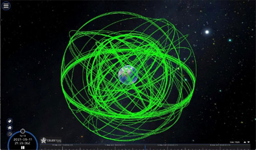
Using the CelesTrak visualization interface to extract space situational awareness data captured by the Combined Force Space Component Command’s 18th Space Control Squadron (18 SPCS) reveals a much more dire image of MEO. Of the 21,266 total tracked objects in Earth’s orbit, 157 are active GNSS satellites, as shown in Figure 3.
Figure 3. Active GNSS satellites. (Image: Celestrak)
However, a total of 4,021 objects reside or pass through MEO, which are either active (331), dead (668), debris (1,761), rocket bodies (1,100) or unknown (161) objects, as shown in this video.
These 4,021 objects represent 19% of the total number of tracked objects from the 18 SPCS space catalog. While the total 21,266 tracked objects is a far cry from the 100 million objects NASA’s Orbital Debris Program Office represents, one can imagine that a significant portion of untracked debris objects, under 10 cm in size, reside or pass through MEO as well. This is significant, according to NASA, which says that objects with a diameter of 1 cm to 10 cm are the most dangerous due to the lack of tracking data, which essentially makes them invisible.
False Sense of Security
The growing orbital-debris concern is a threat too big to ignore. Unfortunately, to date attempts to manage space traffic have amounted to passive measures, such as establishing policy, characterizing the environment, and creating orbital protection guidelines. Even the highly touted, $6 billion U.S. “Space Fence” is a passive measure that contributes nothing active to solve the problem. Not at all a “fence,” it is merely a way to detect the larger and more dangerous debris.
These efforts may, in all actuality, be counterproductive if they instill a false sense of security in the public and government leaders that the problem is being adequately addressed.
A Proactive Solution
Since 1978, the orbital debris population has been touted as our biggest space problem. It is important to do as much as we can with policies and procedures to keep the problem from getting worse faster. However, even if we humans were to completely resist our seemingly natural impulse to pollute everywhere we go, collisions with existing debris would continue to increase the number of dangerous objects in orbit.
Active debris removal (ADR) is the only solution. The sooner it begins, the safer we will all be. Like the oceans and cyberspace, orbital space suffers from the tragedy of the commons. Everyone wants to use it, but no one owns it. No one is responsible for ensuring it is cared for and maintained. As a result, user behavior is difficult to control, and the environment often suffers. Government action, presumably supporting the best interests of all users, is the default answer.
The proposed Space Debris Act of 2021 is a great start. It paves the way for persistent funding and creates an industry responsible for safeguarding humanity’s orbital infrastructure. It would introduce tax credits to incentivize non-government funding contributions and reduce the price of debris removal, so that satellite operators and the emerging space tourism industry can afford to clean up space where they plan to operate.
The bill is currently being presented by OrbitGuardians to members of Congress for sponsorship. Organizations wishing to support these efforts should contact Ken Eppens at OrbitGuardians at [email protected].
GPS/GNSS and other critical space assets are at an unacceptable level of risk from debris. It is time to safeguard orbital infrastructure to protect the interests of the United States and humanity’s future in space.
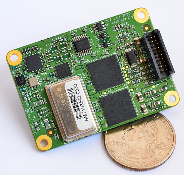
The STL-2600 STL-capable receiver provides a GNSS-independent low SWaP-C UTC-time and location capability
Jackson Labs Technologies Inc. (JLT), a designer and manufacturer of GNSS, timing and frequency equipment, has announced the availability of the STL-2600 Satellite Timing and Location (STL) receiver designed in partnership with Satelles Inc., the STL service provider.
The STL-2600 commercial receiver provides a completely GNSS-independent, low-cost capability to generate UTC nanosecond timing and meters-accurate positioning anywhere in the world. It operates in a way similar to GPS, but without GPS or GNSS. The STL signal has 30-db (1,000 times) higher power compared to GPS signals, allowing the receiver to operate deep indoors independent of any GPS/GNSS signal.
“Useful for non-GNSS-based E911 location and UTC(NIST) timing applications, the STL-2600 receiver is deployable today to fulfill critical infrastructure PNT objectives such as those outlined in Executive Order 13905 on the responsible use of PNT in the U.S. and the emerging mandates for a GNSS-independent backup solution in Europe,” said Said Jackson, president of JLT.
The STL-2600 receiver is also useful in marine applications where GNSS signals are regularly denied or manipulated and for stationary high-accuracy timing applications such as 5G.
The STL-2600 receiver can be directly connected to JLT’s GPS Transcoder products for glue-less retrofit capability of existing customer legacy GPS-only receiver systems to Galileo, GLONASS, BeiDou, QZSS and SBAS as well as adding the STL and optional atomic holdover capability to these legacy systems.
The receiver module combines a custom-designed STL L1 LEO receiver and a latest-generation concurrent-GNSS receiver with a disciplined high-stability reference oscillator sub-system on one circuit board.
Features and specifications of the STL-2600
Photo: JLT
Form factor: 1.4″ x 2.0″ x 0.5″ (36mm x 51 mm x 13mm)
Switching modes: User-selectable automatic and manual switching between GNSS and STL signal reception during jamming or manipulation events
Integration: Incorporates into user systems just like a legacy GNSS receiver would using NMEA and SCPI serial messages, with the use of standard NMEA messages for STL positioning and timing features making system integration trivially easy
Oscillator options and performance: Internal high-stability TXCO standard; capable of directly and gluelessly disciplining numerous optional DOCXO, CSAC and rubidium oscillators for holdover capability, with ultra-stable ADEV performance from 0.1s to infinity with better than 10E-12 stability when using a DOCXO or Rubidium as the holdover oscillator
Low-power consumption: Ranges between 0.7 W to 1.45 W (depending on configuration) allowing for long-term battery operation for use cases without AC power
Antenna support: One GNSS/STL combined standard; optional support of a second antenna for diversity
Interfaces: TTL serial port standard; optional USB serial port allow easy evaluation and design-in
Upgrades: One-button firmware updates performed in situ through any of the serial ports
The receiver includes JLT’s proven frequency and timing disciplining and holdover IP deeply embedded into the entire signal chain for ultra-low phase noise performance and high-stability 1PPS and 10 MHz operation, even when using only the built-in TCXO oscillator.
The unit operates fully autonomously from just a USB cable and is compatible with a customized version of the GPSCon software — offered at no cost to JLT customers — for monitoring and control.
The STL signal has been deployed worldwide since 2016 and can be evaluated and implemented SWaP-C-effectively today via this receiver module.
The STL-2600 is available now. Contact Jackson Labs Technologies for configuration and pricing information.
A new GNSS architecture aboard low-Earth-orbit (LEO) satellites is in development.
The patent-pending system architecture “is combining the efficiency and innovation of the new space era with the world of satellite navigation to help enable modern intelligent systems to operate safely in any conditions, anywhere on the planet,” according to a press release from Xona Space Systems.
Xona, a San Mateo-based startup, announced a service agreement to advance its 2022 Alpha mission. The agreement is with Momentus Inc., a commercial space company offering in-space infrastructure services.
Once complete, Xona’s LEO smallsat constellation will provide a resilient alternative to GNSS with more than 10 times better accuracy, Xona claimed.
“Xona is developing a truly innovative system to enhance the reliability and precision of global PNT and GNSS. As an infrastructure company, Momentus is excited to partner with other like-minded pioneers to help build out the future services needed to enable human presence in space while improving life on earth,” said Dawn Harms, Momentus CEO.
“We have been very impressed with the capabilities and services that Momentus offers with their Vigoride spacecraft,” said Xona CEO Brian Manning. “There is a rapidly growing demand for higher performance navigation and timing services as well as alternatives to GNSS. Forming this partnership with Momentus represents a key milestone in our technology development roadmap as we work towards our on-orbit demonstration and deployment of the full constellation to meet these needs.”