Fugro has completed a hydrographic survey to determine a safe channel through the Star Reef Passage in Papua New Guinea.
Fugro worked with the National Maritime Safety Authority (NMSA) and with funding from the Asia Development Bank (ADB) on the survey, which will be used to update nautical charting and improve coastal zone management.
The project is a key initiative contributing to Papua New Guinea’s sustainable economic development.
Fugro used its LADS HD+ Airborne Lidar Bathymetry (ALB) system, which was deployed with a team of surveyors from both the NMSA and Fugro working in collaboration.
Fugro’s ALB system meets International Hydrographic Organization (IHO) standards with the data now set to be used to update nautical charts. The data was collected safely and with minimal environmental impact on the sensitive reef environment or local marine activity.
Through this Maritime and Waterways Safety Project, Fugro has successfully worked with the NMSA and ADB to help deliver both hydrographic data and training of NMSA staff.
The project is designed to improve the safety and efficiency of international and national shipping in coastal areas and waterways of Papua New Guinea by improving maritime safety information infrastructure and practices and capacity. Safer maritime activities that improve trade and tourism, as well as information to help manage the environment, will bring direct benefit to PNG’s coastal communities.
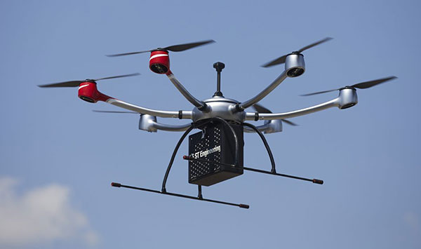
ST Engineering, Sumitomo Corp. and Skyports have formed a consortium to provide unmanned aircraft system (UAS) services for heavy-lift shore-to-ship parcel delivery in Singapore, home to one of the biggest ports in the world
Each consortium member will use its respective operational and technological capabilities to expand the use of UAS for deliveries of maritime essentials to anchored vessels. During a nine-month pilot program, the consortium will engage key customers for maritime UAS deliveries, with the goal of establishing a delivery network capable of carrying parcel payloads of 10 kg.
ST Engineering will provide the UAS technology using its end-to-end solution DroNet. Skyports will jointly conduct the beyond-visual-line-of-sight (BVLOS) flight operations with ST Engineering. Sumitomo Corporation will provide go-to-market support, including its own fleet of vessels.
As an unmanned systems participant in Singapore, ST Engineering has been testing and developing autonomous solutions to enable BVLOS UAS operations for shore-to-ship delivery in close collaboration with regulators and industry partners.
Through funding support from the Civil Aviation Authority of Singapore (CAAS), the group completed the initial development of a UAS for shore-to-ship parcel delivery based on the DroNet solution.
Compared to the traditional form of delivery by boats, UAS operations can significantly slash response time and speed up turnaround for shore-to-ship delivery, in addition to reducing logistics costs. Replacing launch-boat delivery with a UAS service also helps reduce carbon emissions and contribute to the maritime industry’s overall efforts to operate sustainably.
Satellite communications company Inmarsat is working on a United Kingdom Space Agency-funded test project with the European Space Agency to deliver the first UK-generated satellite navigation signal. The project provides a potential platform for the UK to enhance its post-Brexit positioning, navigation and timing (PNT) capabilities.
Repurposing a transponder from the Inmarsat-3 F5 satellite, the test project — known as UK Space-Based Augmentation System (UK SBAS) — will provide an overlay signal to augment the U.S. GPS, refining its accuracy from a few meters to a few centimeters.
UK PNT without EGNOS
The UK no longer has access to the European Geostationary Navigation Overlay Service (EGNOS) Safety of Life services since leaving the European Union (EU) and is not involved in the EU’s Galileo programme for similar reasons. Therefore, this new national capability supported by current and future Inmarsat satellites could offer a new option for high-integrity, precision navigation across the country, in its airspace and within surrounding waters.
UK SBAS will provide a basis to assess its future development into an operational capability to support safety-critical applications such as aircraft approaching and landing at airports or navigating ships through narrow channels, especially at night and in poor weather conditions.
Goonhilly will provide the uplink for the system from Cornwall. Software from GMV NSL, based in Nottingham, will generate the ground-based navigation signal. This is a similar system to that already in use in Australia and New Zealand, supported by Inmarsat.
The project could be crucial for UK users who need accurate, high-integrity navigation capabilities to enable their operations. It will initially cover aviation and maritime operations, but has the potential to extend into rail and other land-vehicle applications. For example, UK SBAS will comply with International Civil Aviation Organization (ICAO) standards.
“It is very welcome news to hear that UK-based companies have teamed up to deliver this ground-breaking project, with help from government funding,” said Transport Minister Trudy Harrison. “From flying planes to steering ships, reliable and precise navigation support is a crucial part of travel. This development is a significant step forward for our world-leading space sector, as we accelerate towards a net-zero transport future.”
Best satellite candidate
Artist’s impression of an Inmarsat-3 satellite. (Image: Inmarsat)
The Inmarsat-3 F5 satellite is in geosynchronous orbit at 54° west, ensuring that its signal covers the UK as part of its Atlantic Ocean region service overlay. This makes it an ideal candidate to participate in the test. The satellite was manufactured by Inmarsat’s Athena partner Lockheed Martin and launched in 1998.
“This project demonstrates British innovation at its best,” said Nick Shave, vice president of Strategic Programmes for Inmarsat Global Government. “Working with Goonhilly Earth Station and GMVNSL, supported by UK funding via the ESA Navigation Innovation and Support Programme (NAVISP), enables us to extend the long life of Inmarsat’s I-3 F5 satellite with additional new services designed two decades after launch.
“We look forward to exploring the potential for this project and the benefits it could deliver to the UK with more precise, high-integrity, resilient navigation services, whilst also exploring future capabilities on new satellites through Inmarsat’s fully funded technology roadmap,” Shave said. “This work also has the potential to be exported to other nations around the world, benefitting the UK economically as well as technologically.”
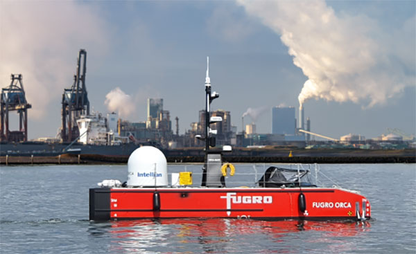
Fugro’s Blue Essence, an offshore certified uncrewed surface vessel (USV) with an electric remotely operated vehicle (eROV), will begin its first project in the Netherlands.
The vessel is controlled from an onshore remote operations center (ROC) via a satellite connection. It will be used for the inspection of offshore assets, construction support services, and hydrographic and geophysical surveys.
USVs play an important role in the future of the maritime sector by improving safety, reducing carbon emissions, and delivering data more efficiently. USV operations remove personnel from high-risk offshore environments to an onshore ROC and reduce carbon footprint by 95 % when compared to traditional survey methods. Cloud-based data processing allows near real-time data delivery, leading to faster and more informed decision making.
“We welcome this special vessel in our port. It’s the first time a remotely controlled uncrewed vessel will go to the North Sea from the port of Rotterdam to carry out a project without any personnel on board,” said René de Vries, Harbour Master of the Rotterdam Port Authority. “We are proud that this project will be executed safely due to the careful preparation of all parties involved. We expect the development of digitalization in the shipping sector will improve the safety and accessibility of the Rotterdam port.”
Since 2020, Fugro has been deploying its Blue Shadow USV fleet for medium- to large-scale hydrographic survey applications. Fugro’s first Blue Essence has completed its first remote inspection, in Asia Pacific.
“I am excited that we now also have this newest generation of USVs available for European clients,” said Erik-Jan Bijvank, group director Europe and Africa at Fugro. “Over the coming years, Fugro will further expand its fleet of USVs for safer, more sustainable solutions for marine operations.”
The General Lighthouse Authorities (GLA) of the United Kingdom and Ireland has named Alan Grant to the top post of its research and development team. Grant assumed his new role on Nov. 1.
As part of his duties, he heads the GLA’s research and development program, considering existing and future maritime requirements and operational strategy. GLA Research and Development (GRAD) is tasked with improving maritime safety by developing innovative and cost-effective maritime aids-to-navigation (AtoN).
GRAD projects have included all aspects of AtoN including human and machine interaction, operational life and environment. The team has deep technical expertise and experience with automatic identification systems (AIS) , the VHF Data Exchange System (VDES) , eLoran, e‑navigation, GNSS, SBAS and visual signaling.
The organization is well known for its expertise in electronic navigation aids and was an important contributor to the MarRINav project. The project effort was funded by the European Space Agency and examined what combination of electronic aids to navigation are needed to ensure uninterrupted UK shipping.
Grant joined the GLA in 2003 and has worked on a variety of systems during his time with GRAD. He led a series of successful GPS jamming trials and the development of the multi-system radionavigation receiver performance standards, from initial concept to international recognition at the IMO. He continues to support resilient positioning, navigation and timing in maritime navigation at both technical and strategic levels.
Grant is a Fellow of the Royal Institute of Navigation, where he is a member of the council and served as vice president, 2019-2021. He is also a member of the U.S. Institute of Navigation and served on the ION Council, 2013-2017.
Grant chairs the International Association of Marine Aids to Navigation and Lighthouse Authorities (IALA) radionavigation services working group and is a member of several international standards bodies. He is a chartered engineer, a chartered physicist, and author of more than 120 journal papers, magazine articles, and conference papers.
Martin Bransby, the prior GRAD leader, has taken a position with Telespazio in the UK.
Longstone Lighthouse is situated on the Outer Farne Islands on the Northumberland Coast in Northern England. (Photo: ad_foto/iStock/Getty Images Plus/Getty Images)
The TopAXYZ inertial navigation unit by Thales. (Image: Thales)
Thales and CS Group partner to offer navies a cybersecure, jam-resistant navigation system inspired by civil aviation
Thales and CS Group have partnered to offer a complete navigation system for navy surface ships. At the heart of the system is the Thales TopAxyz inertial navigation unit, which is integrated with CS Group’s real-time computer to combine high-level performance and resilience in an electronic warfare environment. The system provides high-precision pointing, gyrocompass, location and navigation functionality for all types of naval platforms, from surface combatants and submarines to autonomous vehicles.
The TopAxyz inertial navigation unit has delivered outstanding performance in the rigorous conditions of civil aviation, clocking more than 20 million hours of operation. The naval version of the unit was integrated on a French Navy vessel in less than a day by CS Group, and has already proven its operational value for maritime navigation in a sea trial.
“After proving their value on board aircraft, space launchers and French Army land vehicles, Thales inertial navigation systems are now available for naval platforms,” said Tristan Grivel, vice president business development and sales for Thales’s flight avionics business.
“CS Group has supplied real-time navigation computers, military-grade GPS receivers and other solutions to the French Navy and Naval Group for many years, explained Gilles Rigal, director of CS GROUP’s naval systems business line. “This partnership with Thales allows us to offer an innovative, robust and resilient maritime inertial navigation system for surface ships,” Rigal said.
Countering electronic warfare
In today’s constantly changing naval environment, crews need to contend with the threat of cyberattacks, electronic warfare activity and the high risk of jamming and spoofing of GPS-based radionavigation solutions. Accurate navigation data, real-time data distribution and resistance to external threats are crucial for every mission conducted by a naval vessel today.
Thales and CS Group have worked together for more than 20 years to address these issues. Drawing on their combined expertise across all the key navigation system technologies, the two companies are now proposing a new approach to maritime navigation based on more trustworthy and reliable navigation data.
The TopAxyz inertial unit uses accurate, reliable navigation information that is independent of sea state and vessel location, combined with a function that detects attempts to spoof GPS signals. The navigation data calculated by TopAxyz is distributed in real time by the NDDS (Navigation Data Distribution System) developed by CS Group’s onboard computer.
The computer uses the latest technological advances in cybersecurity, guaranteeing the best level of resilience to attacks. Its architecture offers three key advantages: safer navigation, reduced costs and integration risks, ease of use and simplified maintenance of the system. No calibration is required during the service life of the system, reducing the total cost of ownership.
The new maritime navigation system are now available, and are being manufactured at the companies’ production and integration facilities in Châtellerault and Aix-en-Provence in France.
Thales Alenia Space, a joint venture between Thales (67%) and Leonardo (33%), has been selected by the European Commission for a new strategic contract to assess the feasibility of an integrity service to complement the European Global Navigation Satellite System (EGNSS) High Accuracy service, which will pave the way for use in autonomous vehicles.
Thales Alenia Space will focus on the development of a sensor-fusion approach, including and complementing evolutions of EGNSS High Accuracy. These service evolutions are aimed at providing the integrity level to serve the high-reliability and high-accuracy positioning needs of new, demanding applications such as autonomous vehicles on the road and autonomous transport in the maritime and rail sectors.
With this contract, Thales Alenia Space will assess the extension of the integrity and safety-of-life services for aviation into the road, rail and maritime sectors. In 2020, the company won the EPICURE project, based on an integrity concept for road travel (tolls and insurance), as well as the IMPRESS project, targeting an integrity service for rail signaling and train separation.
Thales Alenia Space has been a prime contractor for EGNOS (European Geostationary Navigation Overlay Service) for 25 years. It is a lead industrial contributor to the Galileo system and its ground mission segment and responsible for providing six Galileo Second Generation satellites. In April, the company was awarded a contract to support the implementation and experimentation of the navigation algorithms that will be used in the Galileo Second Generation program.
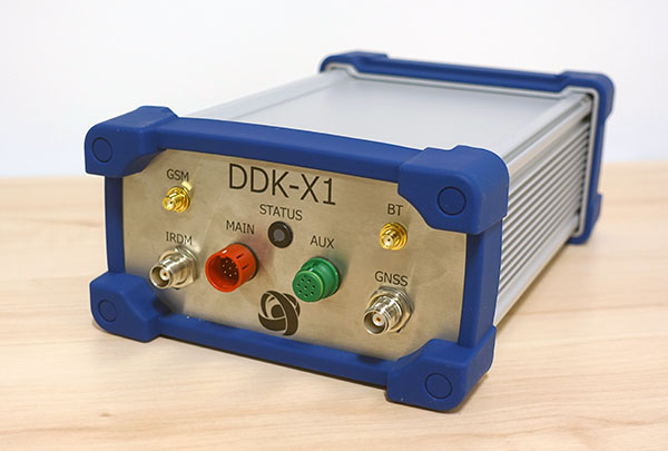
DDK Positioning’s precise GNSS positioning solution provides an accuracy of less than 5 cm
NSSLGlobal has entered a strategic alliance with DDK Positioning, to incorporate enhanced GNSS positioning navigation and timing solutions into NSSLGlobal’s maritime portfolio.
NSSLGlobal will now provide, install and service DDK’s GNSS precise point positioning (PPP) solution which enhances the ability of NSSLGlobal’s customers to precisely locate and track their assets.
DDK’s independent GNSS technology is provided exclusively through Iridium’s global satellite constellation, and creates a robust, resilient and completely independent GNSS solution that has an enhanced accuracy of less than 5 cm, compared to the standard GPS accuracy of 10 m.
“This partnership is a fantastic fit for DDK Positioning,” said Kevin Gaffney, DDK Positioning CEO. “We are now in a place to provide our clients with our precise positioning solutions globally and we are delighted to formalize our working relationship with NSSLGlobal with the signing of this new strategic alliance.
Photo: DDK Positioning
“To continue the journey with such a strong and well-respected company such as NSSLGlobal, and with their reach in the market, makes great sense and we are looking forward to the journey that we will have together.”
“DDK Positioning is leading the field in advanced GNSS positioning,” said Paul Rutherford, service director, NSSLGlobal. “We’re pleased to partner with such an innovative company and to be able to add this technology offering on top of the already extensive navigation and communication portfolio we offer our customers. The system will provide greater location accuracy, along with the ability to help detect and mitigate spoofing.”
A day of ferry trips between Finland and Estonia became some of the best documented voyages in maritime history. Cameras, sensors, radio and satellite navigation receivers and even microphones recorded every instant of the crossings over the Baltic, gathering raw data for a new ESA-led project applying artificial intelligence (AI) to the situational awareness of shipping — as an important step to full autonomy.
The Tallink shipping company’s new 212.2 meter-long Megastar passenger and car ferry was fitted with data-gathering devices for its sailings on the busy stretch of sea between Helsinki and Tallinn.
The testing was overseen by a team from the Finnish Geospatial Research Institute (FGI) for an ESA project called Artificial Intelligence/Machine Learning Sensor Fusion for Autonomous Vessel Navigation, or Maritime AI-NAV.
“Our aim is to show how AI can be applied to achieve autonomous situational awareness, so that a ship can reliably sense its own environment,” said FGI’s Sarang Thombre.
Photo: European Space Agency
“Such autonomous systems would initially be deployed in support of human crews, for enhanced safety and efficiency – with crewless ships a much longer-term goal.
“The most experienced human ship captains will have the least trust in any single navigational device but will rather continuously cross reference between them. Similarly, our autonomous functionality will not be overly reliant on a single data source but combine and verify data from multiple sensors.
“Having gathered many gigabytes of data during our initial August field campaign, then again in October with more days planned in December, we are applying the results to train and test our data-fusing algorithms. A follow-up seagoing test will then verify their performance in practice.”
The Maritime AI-NAV team plans to employ a variety of sensor types, including satellite navigation receivers – also utilizing of Europe’s Galileo system — monocular and stereo cameras, standard radar, “laser radar” lidar and an array of microphones, along with “Automatic Identification System” radio signals. These AIS signals transmit position, size and routing information of all vessels above a certain class, as well as fixed infrastructure such as oil rigs or wind turbines.
“Satellite navigation lets the ship know where it is in the sea, while the other sensors let it know what is around it, which is essential for identifying and avoiding any obstacles,” Thombre said. “The different data sources operate across a variety of ranges — so radar and AIS provide longer range detection out to the horizon, while cameras and lidars come into their own at shorter distances. Plus we had a trio of microphones aboard the Megastar, determining the angle of arrival of sound from other ships. The challenge now is to fully integrate all these sources using machine learning, to build up a holistic picture.”
Maritime AI-NAV is supported through ESA’s Navigation Innovation and Support Programme, working with European industry and academia to develop innovative navigation technology.
FGI is joined in the Maritime AI-NAV consortium by Aalto University’s Sensor Informatics and Medical Technology group and maritime IT startup Fleetrange.
The 1,174 page set of reports are comprehensive and document the first phase of what is intended as a multi-phase effort.
Graphic: RIN and RNTF
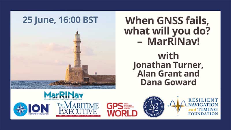
The webinar will present how maritime positioning requirements were systematically developed; an assessment of current and future positioning systems to deliver the required performance and integrity; rigorous gap analysis, showing where performance falls short, as well as options to solve these issues; and a roadmap of steps needed to take — and by whom — toward maritime resilient positioning.
Webinar speakers will include Jonathan Turner of the MarRINav project team, Alan Grant of the Royal Institute of Navigation and Dana Goward of the Resilient Navigation and Timing Foundation.
In 2018 the first-ever European Radionavigation Plan said “It is recognized that [..] GNSS should not be the sole source of PNT information. Alternative PNT systems, not necessarily using radio frequencies, should thus be put in place where the criticality of the application requires it.”
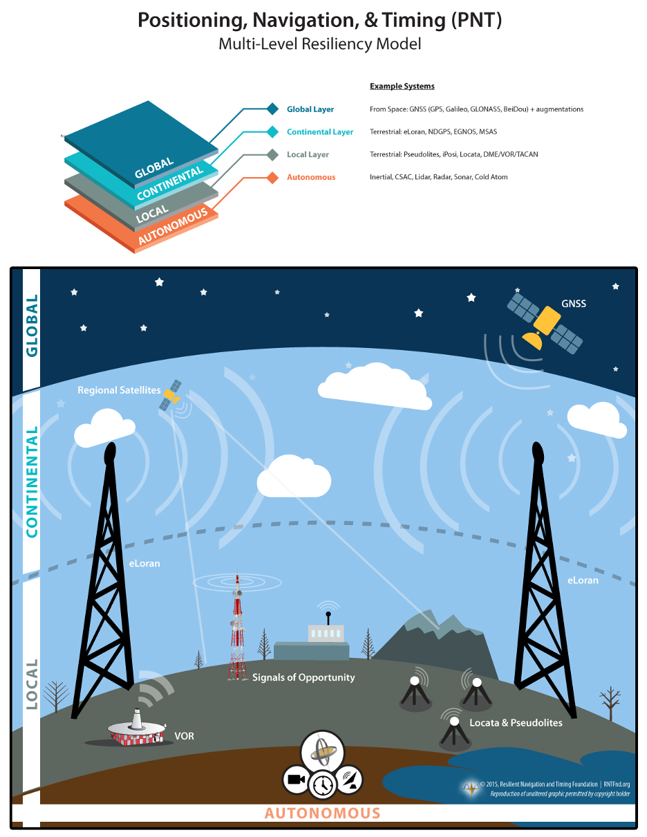
Graphic from MarRINav report showing system of systems approach to PNT resilience and reliability. (Image: Resilient Navigation and Timing Foundation)
In 2019 the European Space Agency (ESA) published a permanent open call for proposals for positioning, navigation, and timing studies and systems, including those that had nothing to do with space.
“Maritime navigation and port operations are critical for almost every nation,” said Jonathan Turner, one of the MarRINav project team. “As an island nation with a strong maritime heritage, we in the United Kingdom perhaps have an even greater appreciation of this.” Turner is co-founder of the blue economy solutions company NLA International, which led a team of eight organizations cooperating on the project.
While MarRINav focused its analysis on the United Kingdom, the intent was to provide information, and an analysis framework, that could also be used by other nations.
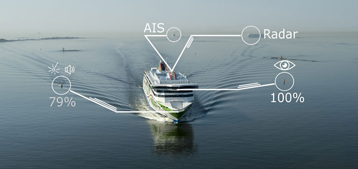
Maritime is one of sectors most dependent upon GNSS, according to the project reports, and a sector with great awareness of GNSS vulnerabilities and their consequences. MarRINav concludes that integrity and resilience are two of the most important parameters for maritime navigation.
Maritime is also one of the sectors most ready to integrate space and terrestrial navigation systems, according to the report’s authors. The International Maritime Organization has already introduced a performance standard for a multi-system receiver, or MSR, that will incorporate a wide variety of navigation signals.
Despite the distractions of Brexit over the last four years, the United Kingdom has been particularly focused on its vulnerability to GNSS outages.
In February of this year the UK government announced it was establishing a virtual National Timing Centre to protect the nation from the risk of GNSS failure, and in March the final MarRINav report was published.
Among the project’s findings are that:
The United Kingdom needs a comprehensive maritime PNT architecture with multiple, diverse sources to ensure continuity of maritime operations
Such a “hybrid solution” could benefit other sectors, especially if non-maritime needs were considered early in the design
New PNT systems should be terrestrial and sovereign
Establishing such a system for the UK has a very positive benefit to cost ratio
Important aspects of the new architecture are E-GNSS (Galileo and EGNOS), Enhanced Loran (eLoran) and the Ranging Mode (R-Mode) of the VHF Data Exchange System (VDES), and complemented by the development of a specific Maritime Receiver Autonomous Integrity Monitoring (M-RAIM) algorithm.
LOCATA or a similar local positioning system should be implemented at UK ports to provide a backup for container operations.
Satelles Satellite Time and Location may have potential, but its utility has yet to be demonstrated for maritime.
A couple of interesting drone applications came up this month — marine smoke emission monitoring and studies from a little known European drone manufacturer.
Monitoring marine emissions
Climate change: Some might say these are words we don’t really need to hear. Such a big to-do about how much human activity is affecting the weather changes that we are now seeing globally. Or is it all part of a natural cycle that the Earth is going through as many might say?
I don’t really want to get into that argument, but it would seem useful that someone is doing something to reduce the use of dirty fuels by ships. After all, we seemed to readily acquiesce to unleaded fuel for our vehicles without a lot of protest; why would we accept this as the norm when marine transport still uses dirty bunker fuel, belching out a significant amount of pollution?
If it’s good for people and their cars, and we quite possibly incurred some costs getting there, why not stick it on the marine industry too?
So that’s what the International Maritime Organization (IMO) did in January this year, reducing the allowable sulphur content in marine fuel from 3.5 to 0.5%. Enforced under the international convention for the prevention of pollution from ships, this is aimed at cutting sulphur oxide emissions from ships by 77%, equivalent to a reduction of about 8.5 million metric tons annually.
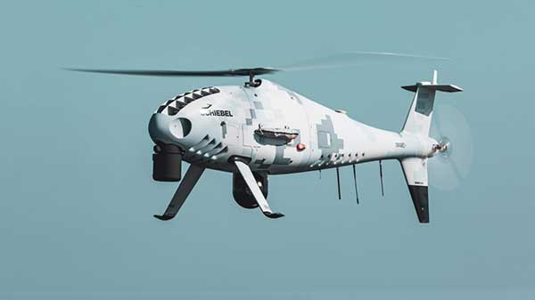
That’s the tricky bit – enforcement. Ships spend most of their time miles away from land, so knowing what their smoke emissions contain is somewhat difficult. Now (this is where I manage to tie things back to what I’m supposed to be reporting on) its useful that Schiebel, along with its partner operator Nordic Unmanned, thought about enforcement of the new regulations.
Schiebel Camcopter S-100. (Photo: Schiebel)
With a range of up to 200 kilometers (~125 miles) the Camcopter S-100 can get out to the shipping lanes to check on what’s coming out of the smokestacks. Equipped with an automatic identification system (AIS), a sulphur sniffing sensor and an L3 Harris Wescam MX-10 real-time electro-optical/infrared (EO/IR) camera, the “enforcement drone” can determine which ship it’s flying over, what the smoke plume sulphur content might be, and even take geo-coded pictures to show in which jurisdiction the ship is sailing. If necessary, it can even take pictures of who’s throwing what at the overflying UAV.
In recent tests, the Camcopter flew out of Gniben, Denmark, where European regulations on emissions applied, and marine exhaust fumes are limited to contain no more than 0.1 percent sulphur oxide. The Camcopter S-100 performed two 4- hour flights and provided real-time readings of the sulphur level in ships’ exhaust plumes.
With these successful tests in the bag, Nordic Unmanned has indicated its capabilities to worldwide maritime authorities that they are ready and able to help enforce the new IMO regulations.
European-built multi-rotor drone
Acecore Technologies in the Netherlands makes multi-rotor drones which have found some unique applications:
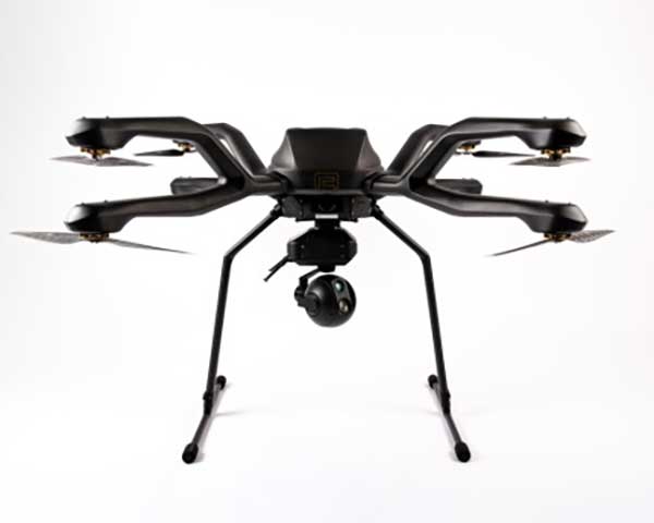
The NEO 8-rotor UAV. (Photo: Acecore)
Stringing power-lines using NEO (SPIE website)
In order to extend power transmission line capacity, the approach used is often to first pull a lead cable. This normally involves several power company personnel and a whole bunch of specialized equipment.
However, in a first-of-its-kind test, SPIE Nederland used an Acecore NEO drone to pull a lead cable over 150 meters between high-voltage pylons.
Equipped with suitable cameras and other sensors, Acecore drones have also been used for power-line and gas-plant thermal inspection, movie making (including Game of Thrones), live broadcasts, autonomous aerial surveying, and tethered security applications. They also make crop health monitoring possible.
Designed with durability in mind, Acecore drones are weather-proof, built with strong carbon-fiber frames, have triple redundant autopilots, and are ADS-B-ready to broadcast GPS position to support sense-and-avoid capability.
Acecore is also promoting the fact that its drones and controllers are manufactured entirely with European parts. In other words, they would like to grab a chunk of DJI’s huge market share by jumping on an apparent global move to switch over from Chinese sourced goods and equipment.
So, drones are taking on environmental monitoring. They’re reducing the environmental impact of transmission-line build-out. And they’re moving toward building drones locally — all are interesting new applications of unmanned aircraft systems.