Tag: Matteo Luccio

  • Hexagon | NovAtel: Taking on land with SMART antennas

    Hexagon | NovAtel: Taking on land with SMART antennas

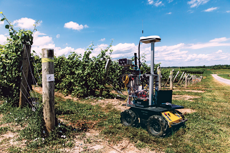
    One of a small army of PhytoPatholoBots (PPB) developed by Cornell University and deployed to four grape breeding programs across the United States. These autonomous robots will roll through vineyards, using computer vision to gather data on the physiological state of each grapevine. They use a NovAtel SMART antenna. (Image: Allison Usavage / Cornell University)
    One of a small army of PhytoPatholoBots (PPB) developed by Cornell University and deployed to four grape breeding programs across the United States. These autonomous robots will roll through vineyards, using computer vision to gather data on the physiological state of each grapevine. They use a NovAtel SMART antenna. (Image: Allison Usavage / Cornell University)

    One GNSS receiver widely used in autonomous ground vehicles is Hexagon | NovAtel’s SMART7 antenna. Matteo Luccio, GPS World’s editor-in-chief, discussed the product and its applications with Haley Lawrance, Senior Positioning Product Manager, Agriculture for Hexagon | NovAtel.

    Luccio: “How do you differentiate your SMART antennas from your other GNSS receivers?”

    Lawrance: “The reason why the SMART antenna portfolio has been so attractive within the agriculture market and to our autonomy customers specifically, has been the ease of integration and the high performance it provides. GNSS positioning is just one part of an autonomous system, and the autonomous integrators don’t necessarily have the volume of machines out of the gate that would justify the development time for them to integrate the OEM components.

    With NovAtel’s SMART antennas, they only need to consider the single cable harness that will run power and communications to and from the receiver – and a single mount point on the vehicle. The SMART antennas offer a waterproof and rugged enclosure, designed to withstand the demanding environments typical for agriculture – and help accelerate our customers’ time to market.”

    Luccio: “Is there some standard, as there is for cars, that enables developers of autonomous systems to easily plug your system into theirs?”

    Lawrance: “We support a variety of communication protocols – serial, CAN, Ethernet, and Wi-Fi. For autonomy, Ethernet tends to be the most common option for communication with the GNSS receiver – especially when using features that require more bandwidth, such as our SPAN GNSS+INS sensor fusion solution that leverages an inertial measurement unit.

    NovAtel’s_OEM7_driver, built for the Robot Operating System (ROS), is a great option because it makes it even quicker for them to integrate and allows the receiver to essentially plug-and-play into the ROS environment with minimal development. For CAN, we support both J1939 Transport and Extended Transport Protocol and NMEA 2000 if they would like to communicate onto an existing bus they are using on the vehicle.”

    Luccio: “What about the ease of integration on the software side?”

    Lawrance: “We have a very large library of proprietary NovAtel-formatted logs that are available in binary and ASCII, which provide flexibility and allow customers to customize a unique set of logs that provide the data they are interested in. This could be anything from information on which satellites are being used in the solution, to the roll and pitch of the vehicle, or status information from the receiver. NovAtel receivers also output in standard formats, such as NMEA 2000 and NMEA 0183, that consolidate the data that they are most likely to need, such as position, velocity, and quality indicators.”

    Luccio: “What markets do your SMART antennas target?”

    Lawrance: “Broadly speaking, the SMART antenna product line was designed specifically for agriculture use cases and environments. Customers include agriculture OEMs, aftermarket integrators that develop retrofit precision ag solutions, and autonomous solution providers.
    Within that product line, we have SMART7 and SMART2, with different performance options that allows us to scale the best product solution for each application. For high-performance semi-autonomous or autonomous applications that need centimetre-level accuracy – even in highly variable terrain and challenging GNSS-obstructed environments, SMART7 is the best fit – together with SPAN GNSS+INS and TerraStar-C PRO Correction Services or RTK.

    For additional positioning redundancy on an autonomous vehicle, SMART2 can be used together with SMART7 – meaning there are two different, independent GNSS hardware, software, and positioning solutions running in parallel. This allows autonomous machinery manufacturers to utilize both positioning solutions in parallel for an additional layer of protection.”

  • First Fix: Arrivals and Departures

    First Fix: Arrivals and Departures

    Matteo Luccio
    Matteo Luccio

    As we begin 2023, GNSS development continues apace, as described in this issue’s annual “Directions” section by representatives of Galileo, GLONASS, and BeiDou. We plan to publish a similar update on the GPS program soon.

    Galileo’s user base now stands at more than 3.5 billion, and the services it provides continue to improve and expand. Beginning early this year, free precise point positioning (PPP) corrections for Galileo and GPS (single- and multi-frequency) will improve real-time user position by up to 10 times. While the discontinuation of Soyuz launch services from the Kourou Space Centre in French Guiana, due to the Russia-Ukraine conflict, delayed the two Galileo launches that had been planned for last year, 2022 was a key year for the development of Galileo Second Generation (G2G) satellites. They will provide, among other innovations, a reconfigurable fully digital navigation payload, point-to-point connection between satellites, and advanced jamming and spoofing protection mechanisms.

    On Nov. 29, 2022, Russia launched the 51st Glonass-M satellite, about 20 years after launching the first one. Currently, 13 of these satellites are operating beyond their guaranteed lifetime, with an average orbit lifetime of more than 10 years. Starting this year, the constellation will be renewed by Glonass-K and Glonass-K2 satellites, which provide CDMA signals to users.

    Currently, 45 BDS satellites are operational in orbits, including 15 BDS-2 satellites and 30 BDS-3 satellites. The constellation says that it has reached a continuity of 99.996% and an availability of 99%, with a global positioning accuracy better than 1.5 meters horizontally and 2.5 meters vertically (95% confidence).

    Tracy Cozzens, who has been a pillar of this magazine for 17 years, is retiring this month. We will miss her journalistic acumen, dedication to clarity and style, attention to detail, and wealth of institutional knowledge. We wish her a well-deserved retirement. At the same time, we welcome aboard Maddie Saines, our new managing editor, who is near the beginning of her career.

    I am pleased to announce that Rob VanBrunt has joined GPS World’s Editorial Advisory Board. In mid-December, the board of directors of Spirent Federal Systems, a provider of PNT test solutions for the U.S. government and contractors, appointed him as the company’s president/CEO-designate, a role he will assume when the onboarding process is complete.

    VanBrunt began his career at Spirent Communications in 1990 as product developer and manager, and then held posts of increasing responsibilities, moving to director and vice president roles focused on management, strategy and mergers and acquisitions. Most recently, he was executive vice president in the Office of Business Excellence. VanBrunt has a B.S. in electrical and electronics engineering from Rutgers University.

    Spirent Communications is a global provider of automated test and assurance solutions for networks, cybersecurity and positioning. In July 2001, the company formed Spirent Federal Systems as a wholly owned subsidiary and U.S. proxy company. Spirent Federal markets and sells Spirent Communications’ products in North America. It also provides value-added features and ongoing customer support.

    On Jan. 1, I lost my beloved mother, Maristella “Mimi” Luccio. She was 87.

    Matteo Luccio | Editor-in-Chief
    [email protected]

  • Many technologies can help GNSS, but few can replace it

    Many technologies can help GNSS, but few can replace it

    Matteo Luccio
    Matteo Luccio

    Alternative. Complementary. Backup. Co-primary. These are some of the terms used to refer to sources of positioning, navigation and timing (PNT) data other than GNSS satellites.

    The four current GNSS constellations — supplemented by two regional ones and by public and private augmentation systems — have firmly established themselves as the primary source of PNT data by virtue of their accuracy, reliability, global coverage and ubiquitous use. Yet, this widespread dependency on them — especially on GPS — coupled with their well-known vulnerabilities to jamming, spoofing, other RF interference, multipath, solar flares and space debris (see page 10) — make the development of alternative sources of PNT data imperative. In fact, the U.S. Congress has repeatedly mandated it.

    Typically, when talking about alternative PNT, we are referring to sources of PNT data that either were not originally developed for navigation purposes — such as television broadcast towers used as “beacons of opportunity” — or that use a higher broadcast power or a different frequency band than GNSS. They include legacy systems and new versions of legacy systems, such as eLoran.


    “The only replacement for a GNSS is another GNSS.”


    Other non-GNSS sources of PNT data have a wide range of benefits, limitations and costs, including infrastructure requirements. Most provide only the P and the N, or only the T, in PNT. Inertial systems, for example, once initialized can provide positioning and navigation, but need to be periodically re-initialized to compensate for their drift. Therefore, while excellent for maintaining the navigation solution during short GNSS outages and very helpful in identifying false GNSS measurements due to multipath, they are no replacement for GNSS. Cameras, radar and lidar, while often excellent sources of relative positioning, cannot provide absolute positioning.

    It is even harder to replace GNSS when it comes to timing. Already enormously important in synchronizing the Internet, financial transactions and broadcasting, this service is essential to the development of complex new systems, such as integrating autonomous and legacy vehicles into digital traffic networks.

    As in other human enterprises, the key to resiliency in PNT is diversity: a mix of systems based on sufficiently distinct technological foundations so that a threat to one does not imperil the other ones. Additionally, having a variety of available sources of PNT data will enable users to choose the ones most suited to their platforms.

    However, we need to distinguish between technologies that can assist GNSS, such as inertial, and those that could substitute GNSS. I agree with Chuck Schue’s definition of the latter (see cover story, page 28): “an alternative PNT solution is one that is readily available; provides an easy and seamless transition to/from the primary or other alternatives; allows continuity of operation at a possibly degraded, yet usable, level of accuracy, availability, integrity or continuity; and is dissimilar enough from the primary solution to withstand the effects that might be affecting it.”

    Ultimately, Schue pointed out to me, “the only replacement for a GNSS is another GNSS.” So, let us stop referring to systems that are not true substitutes for GNSS as “alternative PNT.” Complementary is a more appropriate adjective.

  • Mapping rights-of-way subject of July 13 virtual conference

    Mapping rights-of-way subject of July 13 virtual conference

    Photo: Jordanlye/iStock/Getty Images Plu/Getty Images
    Photo: Jordanlye/iStock/Getty Images Plu/Getty Images

    The 2021 Right-of-Way Asset Mapping Exchange is an interactive online Virtual Conference Experience focusing on innovation in asset inventory and mapping that supports all phases of infrastructure lifecycles. It takes place July 13 and is free of charge.

    The event provides hands-on actionable information on a variety of current and emerging technologies. Via presentations, discussions and one-on-one meetings, the event gives those who attend an opportunity to learn from and engage with technology and experts in a wide range of disciplines, and some of their key clients, as well as peers and colleagues.

    Moderator of the event is Matteo Luccio, GPS World editor in chief. Speakers include:

    Why ROW Asset Mapping?

    ​Right-of-way (ROW) corridors, especially in urban areas, are densely populated by many public and private infrastructure features — overhead electric and telephone wires, street-level parking meters, signage, traffic sensors, underground fiber-optic cables, water mains, natural gas pipes and sewers. They are constantly changing environments, as additional poles, signs and conduits are installed and old ones are replaced with newer ones to restore service after storm damage.

    Yet public works and utility managers, engineers and planners need to know what each stretch of each ROW corridor contains at any given moment, especially as they work to make our cities “smarter.” Hence, the Sisyphean task of mapping these assets.

    Fortunately, the technology to map ROW assets is rapidly improving. Platforms for data collection include vehicles driving at normal traffic speeds, UAVs and manned aircraft. Sensors include digital cameras, lidar scanners and ground-penetrating radar.

    Visualization tools include augmented reality, virtual reality, mixed reality and models ranging from small 2D and 3D ones of individual features up to digital twins of buildings and, eventually, entire cities. Increasingly, the tedious work of identifying and classifying features is being delegated to automated feature extraction software, a form of artificial intelligence.

    The conference will discuss

    • Comparing 2D and 3D visualization tools.
    • Explaining the benefits of 3D models as an advanced spatial analysis tool for urban planning.
    • Exploring the future of smart cities and digital twins.
    • A light equity study and pole inventory in the context of the transition to LED lighting.
    • How a two-man team can capture 500 miles worth of utility data in two weeks.

    Registration is free.

  • First Fix: Let’s start a conversation

    First Fix: Let’s start a conversation

    Matteo Luccio
    Matteo Luccio

    Last year, GPS World marked its 30th anniversary. That is a testimony to this magazine’s continued relevance, its commitment to its marketing partners, and its unmatched audited audience of 54,000 GNSS/PNT buyers, integrators and specifiers.

    Taking on my new role on GPS World’s edit team was a homecoming of sorts because I began my current career a little more than 20 years ago as this magazine’s managing editor. I look forward to an ongoing conversation with many of you in the GNSS/PNT community — scientists, engineers, civil servants, uniformed service members, company executives and product managers. You may get an email message from me, and I will always welcome yours, at the e-mail address below.


    “I look forward to an ongoing conversation with many of you in the GNSS/PNT community.”


    Let me tell you a little about three passions that led me to this job.

    Navigation has been one of my passions since I was a kid. When I was five years old, I lost track of my mother as she entered a store in Berkeley, California, and I kept walking down the street. It happened again when I was seven and had insisted on walking home alone from school in Milan, Italy. I was determined never to get lost again. So, when I was 11 and my family moved to Pisa, I was the only kid I knew who walked around — from school to sabre-fencing practice, to piano lessons, to my bus stop — studying a map and a compass. When I was 13, in shop class, I built a crude optical-range finder, based on trigonometry. Next, came the topo maps I used for hiking the hills and mountains of Tuscany. A few years later, as a graduate student at MIT, I began to sail around the Boston Harbor islands and off the coast of Maine. I learned to navigate using nautical charts, sextants, radio direction-finders, sonar, radar, Loran-C and, finally, GPS receivers.

    Magazine journalism has been another one of my passions, since I co-founded a public policy magazine, Oregon’s Future, 25 years ago and became its editor. That was the first of seven editorial positions with magazines I have had over the past quarter century. Finally, my passion for public policy led me to degrees in political science and to my previous career as a research analyst — first for an independent research institute, then for state and local government. It gave me a solid grounding in public policy, statistical analysis and querying large databases.
    So, this navigation enthusiast, policy wonk and experienced writer and editor is now in position to report on and advocate for the continuing growth and development of GNSS. I will also showcase new products and projects, and present facts and opinions from across the GNSS/PNT community.

    This month’s cover story on autonomous vehicles is a perfect example. It confirms the central role of GNSS in one of the most significant technological advances we can expect to see in the coming decade — having vast implications for our society and environment — with facts and opinions from four industry leaders.

    Matteo Luccio | Editor-in-Chief
    [email protected]

  • NCM hires Luccio as GPS World Editor-in-Chief

    NCM hires Luccio as GPS World Editor-in-Chief

    Headshot: Matteo Luccio
    Matteo Luccio

    North Coast Media (NCM) has hired Matteo Luccio as editor-in-chief of GPS World, the industry’s most-trusted resource since 1990. Luccio possesses more than 20 years of experience as a writer and editor for various geospatial, GNSS and positioning, navigation and timing (PNT) media.

    “I am thrilled to help guide the editorial team of GPS World, the undisputed GNSS/PNT media leader,” said Editor-in-Chief Matteo Luccio. “Our content will continue to be driven by our unparalleled audited audience of 54,000-plus engineers designing solutions to today’s most-pressing GNSS/PNT challenges.”

    Luccio began his current career in 2000, serving as managing editor of GPS World and Galileo’s World. After that, he served as editor and publisher of GPS User, and editor of Earth Observation Magazine and GIS Monitor. He has served as a columnist for Professional Surveyor, a contributing writer for Apogeo Spatial and xyHt, and a special correspondent for Sensors and Systems. He also has written for ArcNews, ArcWatch, GeoWorld, GIM International, and GEO Informatics.

    The past several years, Matteo has served as a GPS World contributing editor, reporting on new technologies and applications for GNSS receivers, antennas, simulators, and alternative PNT solutions. Luccio holds a master’s degree from the Massachusetts Institute of Technology (MIT).

    Luccio will work closely with Marty Whitford, Editorial Director and Publisher; Tracy Cozzens, Senior Editor; Diane Sofranec, Staff Editor; Wes Temple, Digital Media Editor; and Charles Park, Art Director.

    “Matteo has come full circle, returning full time to GPS World, where he began his stellar GNSS/PNT career,” Whitford said. “We’re excited to have Matteo share GPS World’s edit helm, helping our readers and marketing partners position for maximum growth for years to come.”

  • The shape of water: bathymetry in action

    The shape of water: bathymetry in action

    As the skipper of Galileo 4, a 50-foot sailboat on the Columbia River, I instruct my crew to alert me if the water under the keel drops below 10 feet and take immediate action if it drops below 5 feet, because I cannot constantly monitor my chart to avoid running aground. Yet, the huge cargo ships that navigate the river for 100 miles from its mouth at Astoria to the Port of Portland sometimes have as little as two feet of vertical clearance.

    This feat of navigation is made possible by the knowledge, experience and electronic equipment used by the river pilots who steer the ships, the hydrographers who survey the river, and the dredge operators who perform the Sisyphean task of maintaining the required depth of the navigation channel. Each additional inch of draft they enable allows a ship to carry additional cargo worth up to several million dollars.

    In similar ways, marine professionals around the world cooperate to chart ocean bottoms and to keep ports, harbors and navigable waterways safe for the more than 90% of trade that is carried by ships. Additionally, off-shore installations—such as fiber optic cables, pipelines, drilling platforms and wind turbines—all require accurate surveys of the ocean floor. Finally, population growth in coastal areas and sea level rise due to climate change are driving the need for bathymetric data for planning and emergency management.

    Bathymetry

    For centuries, mariners recorded water depth using nothing more than a lead line, a compass, a sextant and a rudimentary nautical chart. This was such a time-consuming process, however, that they could only perform it for a tiny percentage of the world’s oceans and coastlines. Today’s technology makes the process not only more accurate, but also vastly more efficient.

    In deep waters, depth data is collected using huge multi-beam echo sounders (MBES) that operate at very low frequencies. As the depth decreases, smaller devices are used that operate at higher frequencies and, therefore, have higher resolution. However, close to shore, the efficiency of these devices drops dramatically, as the cone of their sound signal is cut off by the slope of the shelf. This is where airborne lidar sensors become a much more efficient means of collecting depth data.

    In addition to data from the sounders, bathymetry requires data about the vessel’s location and attitude. The former, an obvious requirement for any kind of mapping, are collected by differential GNSS receivers. The latter, collected by an inertial measurement unit (IMU), are used to compensate for variations in the depth measurement depending on the vessel’s rotational movements (roll, pitch and yaw) and translational movements (heave, surge and sway). This is the same reason that aerial photogrammetrists use IMUs on aircraft.

    Challenges

    Traditionally, MBES systems have been large, complex and expensive. However, they are rapidly becoming smaller, cheaper, quicker to deploy, and easier to use thanks in part to the introduction of inertial systems that use microelectromechanical systems (MEMS), said Ludovic Bazin, technical support manager for SBG Systems, which specializes in MEMS technology. “You can see that the new systems are being increasingly deployed in smaller autonomous vehicles, on smaller autonomous surface vessels (ASV), and even smaller vessels. So, people can go quickly in operation,” he said. An additional advantage, he pointed out, is that they do not require an export license.

    A key to accurate bathymetric surveys is reducing the error budget aboard the vessel, where the survey positions are tied back to a GNSS antenna. “You have errors all the way through the system,” said Richard Turner, vice president of global marine sales for Hexagon’s Autonomy & Positioning division, which caters mostly to the market for survey related to oil and gas. He attributes the largest improvements in recent years to the increase in accuracy using precise point positioning (PPP). “If you are out of range of real-time kinematic (RTK) and any other near-shore positioning, the accuracy of PPP is constantly improving,” he said. “It is getting down into the five-centimeter range horizontal or better than that.”

    Turner also pointed to the tight integration of inertial navigation system (INS) technology with other systems. “Every time you improve the accuracy of your system the specs go up,” he said. Therefore, the challenge is to ensure that the equipment is installed properly, which requires very accurate offset measurements. “It is no good having two centimeters position accuracy if your heading or your offsets are wrong.” Generally, he points out, boats are not designed for this type of installation, due to such things as long cable runs.

    Hexagon will send surveyors out with equipment from Leica, one of its divisions, to do the dimensional control and to calibrate the gyroscopes, which are another source of error. In 2014, Hexagon acquired Veripos. “Many of the people in the Veripos organization come from the offshore survey world or the dredging world, so it is very marine focused,” said Turner. “No other providers have the marine experience that we do.”

    For bathymetric software companies, the main current challenge is “keeping up with all the modern and cheaper hardware,” including RTK receivers, echo sounders, and side scan sonars, said Leon Steijger, owner and programmer at Eye4Software B.V., which makes the Hydromagic software.

    Requirements and capabilities

    To get accurate data, all position and depth records must be timestamped with high precision so that the location of the echo sounder pings can be calculated during post-processing, Steijger noted. “The software needs to be able to generate elevation maps, depth contours, and 3D terrain views and must support volume calculations to calculate how much water there is in a basin, or to determine how much material has been removed during dredging operations.”

    Hydromagic uses “plugins,” which are pieces of software that are loaded optionally to interface sensors with the software. “For some hardware we also offer a plugin containing a user interface that can be used to, for instance, upload a planned route to an automatic pilot or to control the signal processing parameters of an echo sounder.” Operators only need to specify the dimensions of their vessel and correct for the sound velocity and the static draft (the distance between the water surface and transducer). They see the vessel’s track in real time, but the rest of the data are post-processed.

    Hexagon controls its own correction services and the network that delivers them. “We obviously build our own GPS receivers, so we can tightly integrate inertial systems,” said Turner. “We use third-party inertial systems. However, because we have access to the tracking loops on the GNSS boards, we can tightly integrate that inertial system so it gives a level of coupling that’s difficult unless you are actually building those boards yourself.” While near-shore operations can use RTK or post-processing, he pointed out, “the offshore guys often use real-time positioning to collect data for oil and gas. And that is really where we come to the party, because we have all those services too.”

    SBG Systems designs, manufactures, and calibrates its own IMUs, then integrates them with GNSS boards, creating OEM products. “We also design and produce our own firmware algorithms to merge all those datasets,” said Bazin. “From the selection of the MEMS sensor to the final product, SBG will design, manufacture, develop, and produce the entire systems. We also provide tools for people to integrate our systems to develop their own libraries or to integrate our libraries into their systems and work with some integrators for APIs so they can control our systems from their own application.” The company’s post-processing system, Qinertia, integrates GNSS corrections with raw IMU data. “So, when we do post-processing, we reprocess an entire solution at the end for position, but also for stabilization for pitch, roll and heading,” Bazin explained. One of the benefits is the ability to remove many multipath effects.

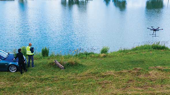
    For bathymetric surveys using an unmanned aerial vehicle (UAV), the control software must keep the platform at a constant altitude and speed over the surface of the water, because the echo sounder is dragged through the water at the end of a cable, explained Alexey Dobrovolsky, CTO of SPH Engineering, based in Riga, Latvia, which delivers UAV-related software. Therefore, he said, “missions should be executed in a fully automated mode.” His company’s software only requires the UAV’s operator to define the survey area, set the direction of the survey lines, and specify the distance between them. The software will handle everything else. “We automatically recalculate the depth measured from the echo sounder to the real depth in our data files using data from a radar altimeter,” he said. “Our software contains a high-end model of the echo sounder, which has a tilt sensor and a pitch sensor.”

    Of course, dragging an echo sounder from a UAV only works for small areas, such as in open pit mines where the liquid can be very contaminated. “The flight time with an echo sounder of the most popular UAV will be around 20 minutes,” said Dobrovolsky. “That determines the maximum length of the survey lines that can be covered by a single flight.”

    A couple of years ago, SPH began to provide some UAV-based bathymetry solutions that use low frequency ground-penetrating radar (GPR). There are two scenarios when GPR can be useful for bathymetry, Dobrovolsky explained. The first one is to do bathymetry through ice on the surface of lakes or rivers, which would require drilling holes to use an echo sounder. “With GPR, you can do bathymetry through the ice layer,” he said. The second scenario is mountain rivers with extremely strong currents, when it is not possible to use a standard manned or unmanned boat, because GPR works without contact with the water.

    Bathymetric systems are now also deployed on autonomous underwater vehicles (AUVs) that are only one to three feet long. “MEMS INS are compact and can be integrated directly with MBES systems, which provide an all-in-one compact system that can be easily deployed and operated because they are lightweight and their mechanical alignments are known and fixed,” said Bazin. “Some of these systems can go 2,000 meters below the surface of the water.” In post-processing, he pointed out, some MEMS INS can have an angular accuracy as low as 0.07 degrees for the vessel’s pitch and roll and a heading accuracy of as little as 0.01 degrees.

    Outputs

    To integrate diverse sensors with a UAV, SPH developed an onboard computer, called UgCS SkyHub, that logs data from the sensors. In the case of the echo sounder, it can be an NMEA stream or just a stream of current depth measurements, said Dobrovolsky. The device is also connected to the UAV’s autopilot, so it logs the platform’s position and speed, and with the altimeter. UgCS SkyHub can record three types of data files: a CSV file containing the coordinates, depths, and a few additional parameters; a file in NMEA 0183 format, which is also standard for bathymetry; and a SEG-Y file containing the full echo sounder data, including, for example, sediments and objects in the water.

    SBG Systems’ software has two kinds of outputs, Bazin explained. First, a proprietary binary format, as well as NMEA and ASCII formats, that are used to provide stabilization and navigation for the platform in real-time. Second, a standard as-built survey format for post-processing. “Then, we have very powerful tools to output ASCII files that are completely configurable from header to footer,” he added.

    Eye4Software’s main outputs are volume reports or plot sheets for end customers containing a map with depth colors and depth contours, as well as cross section views or XYZ export files for further processing in, for instance, AutoDesk Civil 3D and AutoCAD.


    Feature image: A UAV from SPH Engineering tows a bathymetric sonar just under the surface of a river. (Photo: SPH Engineering)
  • Developing systems to automate moving groups of trucks

    Developing systems to automate moving groups of trucks

    In the United States, trucking companies and the Army are both developing systems to automate moving groups of trucks. While trucking companies are mostly interested in “platoons” of trucks drafting off of each other to save fuel, the Army wants its “convoyed” trucks to be hundreds of meters apart to improve their chances of surviving an enemy attack.

    Battlefield challenges

    While the biggest danger for platoons of commercial trucks is crashing, military convoys can be threatened by attacks with improvised explosive devices (IEDs) or rocket-propelled grenades.

    Civilian truck drivers also benefit from a robust infrastructure, said Bernard Theisen, division chief for Ground Vehicle Robotics at the U.S. Army’s Ground Vehicles Systems Center (GVSC). For example, nearly all platooning trucks are limited to using roads and highways that have been mapped at centimeter-level resolution with lidar, can communicate over 3G or 4G networks, and have excellent GNSS signals. “I would love to have all that information,” Theisen said, “every time I send a robotic convoy vehicle out there.”

    By contrast, the military must design a system that assumes “no comms, no prior data, and no infrastructure,” Theisen explained. “Sometimes a bridge that used to be there has been blown up or we may have put a new bridge across the water overnight. A building that was there yesterday got blown up and is now blocking the road. You cannot pre-plan that in the map and expect it not to change.”

    Nevertheless, the civilian and military efforts share some challenges, Theisen acknowledged, including “perceiving the world, understanding it, processing the data, and making the right decisions.” Unlike robots, humans are very good at coping with the unexpected. “You can only train a robot so much, there will always be situations that it does not know how to handle.”

    In a military convoy, every fourth or fifth truck may have a mounted gun to protect the convoy. The convoy will typically include one or more ambulances, wreckers and fuel tankers. “It is a different application than for Amazon or FedEx to send a couple of trucks down the highway,” Theisen said.

    Leader-follower

    In leader-follower applications, GVSC installs the same hardware on all its trucks. “This facilitates software maintenance, because you don’t need to have different versions,” Theisen said. If the convoy’s leader is disabled from a mechanical or battlefield issue, it is easy for a soldier on the next truck to authorize his truck to take over as the convoy’s new leader. “We have also created cases where the leader takes that road months ahead of the followers,” said Alberto Lacaze, co-founder and president of Robotic Research. “So, the leader does not need to be a part of the convoy.”

    Rough terrain doesn’t affect navigation, except that in hilly terrain trucks might have more side-to-side drift than in a flat area. “We often use a three-axis IMU [inertial measurement unit] instead of a two-axis IMU, which might be all you need for a commercial application on flat roads,” Theisen said.

    “The commercial problem is almost like carrying a group of trailers that are not mechanically connected,” Lacaze said. It is crucial to be able to tie in the vehicles’ low-level controls so that they maintain a very short separation. If those vehicles were trying too hard to maintain those very close distances by frequently accelerating and decelerating, the fuel-savings advantages from drafting would go away. By contrast, for military applications the exact distance between the trucks doesn’t matter much, but their side-to-side error does. “You would like all vehicles to be driving within one tire width of the lead vehicle’s tracks,” Lacaze said. “That has many advantages — for example, if that road has been demined.”

    While commercial and military software largely overlap, their sensor requirements are fundamentally different. “Most commercial vehicles are not checking to see whether there is a crater in the middle of the road,” Lacaze said. Military vehicles need to detect such damage to the infrastructure and respond quickly.

    Still, the military is interested in “the gigantic amount of mapping of the available infrastructure” being done by private companies, Lacaze said, because most military convoys are not in war-torn areas, but delivering materiel to bases in areas with some infrastructure.

    Robotic modes

    GVSC purchases commercial off-the-shelf (COTS) systems and integrates them into its trucks, Theisen explained, producing five robotic modes:

    • Warning, which consists of “idiot lights” and buzzers alerting human drivers that, for example, they are straying out of a lane or are about to hit something
    • Driver assist mode, which helps drivers brake, accelerate and steer
    • Teleoperation, which consists of driving the truck from a remote location
    • Waypoint navigation, which uses a GNSS waypoint path that can either be pre-programmed or pre-driven and then replayed
    • Leader-follower, in which the first vehicle leads and potentially any number of vehicles follow.

    Regarding the driver assist mode, Theisen pointed out that “all these features are very common in high-end cars and you are seeing them coming into many Class 8 trucks. We don’t do any development in the Army from that standpoint.” Regarding the leader-follower mode, the first truck can be driven in any of the other four modes.

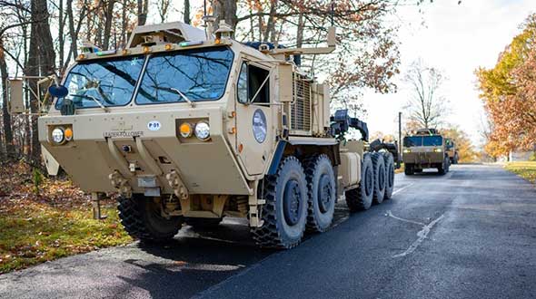
    GVSC is the lead system integrator for 30 robotic palletized loading systems (PLSs) that the Army has at Fort Polk, Louisiana, and another 30 at Fort Sill, Oklahoma. Nevertheless, a human driver usually leads the robotic convoy. The driver determines the best route, assesses the situation, and is normally followed by three unmanned systems. “That is why we call our system semi-autonomous,” Theisen said.

    The role of GNSS

    The Olli shuttle, equipped with Robotic Research’s AutoDrive kit, is deployed on busy boardwalks, campuses and public roads. (Photo: Robotic Research)
    The Olli shuttle, equipped with Robotic Research’s AutoDrive kit, is deployed on busy boardwalks, campuses and public roads. (Photo: Robotic Research)

    For both commercial platooning and military convoying, GNSS signals are used for redundancy but not as the primary source of measurement of the distance between the trucks. “None of the systems that we have deployed on the commercial side — for example, with Local Motors vehicles (the Olli shuttle) — rely on GNSS,” Lacaze said, though they will use those signals if available. The high accuracy of their inertial systems make it hard to spoof or jam GNSS receivers, because the system would detect any changes in the GNSS solution and the vehicles would continue running on inertial navigation if the GNSS signal were jammed.

    “We assume that we will not have GNSS information because sometimes we are jamming ourselves or are being jammed or the enemy could be spoofing us,” Theisen said. Most of GVSC’s systems use “nav boxes” sold by multiple vendors that enable vehicles to navigate for long periods without GNSS signals. They typically combine one or two GNSS receivers, an IMU or several smaller ones, a combination of wheel encoders or ground sensors to determine ground speed, and a digital compass.

    GVSC’s trucks also use lidar to generate voxel maps of their current surroundings, and then share them with the other trucks in the convoy. Each vehicle tracks the vehicle in front of it and can just follow it, if it has insufficient position information or good visual cues.

    GVSC looks for the highest possible GNSS accuracy, whether using civilian GNSS receivers or military Selective Availability Anti-Spoofing Module (SAASM) units. “We also take advantage of the future M-code,” Theisen said. “We do have capabilities that the civilian marketplace does not have.”

    Remaining obstacles

    The remaining bottleneck in the development and implementation of convoys of autonomous military vehicles is the approval process, Lacaze said. “Currently, if we make changes to the autonomy systems, the testing parts of the government are asking us to drive hundreds of thousands of miles before providing approvals. It is still a challenge to figure out at what point these vehicles are safe enough to provide to the soldiers and what the cost of doing so is.”

    For these systems to take off, better processors, sensors (cameras, radars and lidars) and algorithms are required, Theisen said. “There is way more sensor data that you can collect and process in real time.”


    Featured photo, provided by Robotic Research: Army convoys can stretch for miles. The U.S. Army’s Autonomous Ground Resupply trucks shown here are connected with Robotic Research’s autonomous technology. 

  • Lidar a viable tool for archeological exploration

    Lidar a viable tool for archeological exploration

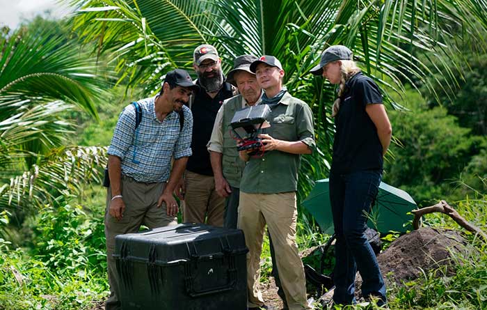
    PrecisionHawk’s Jaymie Young and Matt Tompkins fly a UAV with the hosts of History Channel’s “Lost Gold of World II” in the Philippines in late 2018. (Photo: PrecisionHawk)
    PrecisionHawk’s Jaymie Young and Matt Tompkins fly a UAV with the hosts of History Channel’s “Lost Gold of World II” in the Philippines in late 2018. (Photo: PrecisionHawk)

    The collection of about 300 giant geoglyphs known as Nasca Lines were etched into the ground in the Peruvian coastal plain 2,000 years ago by the Nasca culture in South America. They depict various plants, animals, and shapes and are so large that they can only be fully appreciated when viewed from the air. Unlike the Nasca Lines, most archaeological sites are hard to see from the air, especially those deep under thick jungle vegetation, as in the lowlands of northern Guatemala. Here, lidar’s ability to penetrate foliage makes it the ideal tool for archeological exploration. At the same time, the lack of infrastructure, including airports, makes UAVs the platform of choice for many such projects.

    Challenges for lidar in archaeology

    Operating aerial lidar for archaeology in a jungle environment presents four challenges. The biggest one is penetrating the canopy. “Typically, the sites that they have been exploring lately have been quite overgrown, and disguising what has been there for a long time, to the extent that even someone walking on the ground has not been able to see the scope of the site,” said Paul LaRocque, senior scientist at Teledyne Optech. Penetrating multiple layers of vegetation requires a minimum of two lidar returns. For heavily vegetated environments, Matt Tompkins, director of Flight Services at PrecisionHawk, recommends a five-return system.

    The second challenge is ground-truthing the data collected, explained Thomas Garrison, assistant professor in Ithaca College’s Department of Anthropology. “Even though we digitally removed the forest, it is still there, of course.” For example, it is hard to confirm long roads between sites, because they run beyond a ground observer’s field of vision.

    The third challenge is acquiring a GPS signal. “In the tropical environment, a UAV needs to return to its take-off site very precisely,” Garrison explained. Finally, jungles put a twist on the familiar trade-offs between fixed-wing and rotary-wing UAVs: “A fixed-wing UAV will cover a greater area, but you may not have enough space for it to take off where you want to fly your lidar and may not be able to recover it,” Garrison said.

    Making lidar an effective tool for archaeology required the development of sensors with very high pulse repetition frequencies (PRF) and with multi-look angles, which better penetrate the canopy to reach the ground and any structures, LaRocque explained.

    Manned aircraft vs. UAVs

    Archaeology missions need aerial lidar sensors with sufficient peak power from each pulse to reach the ground after much of it is absorbed or reflected by the canopy. In this respect, manned fixed- and rotary-wing aircraft have an advantage over UAVs because they can carry larger sensors with a higher peak power. Plus, they can cover much larger areas per flight. “This is important because archaeologists have been finding that [areas of interest] are much bigger than they ever imagined,” LaRocque said.

    Finally, forests and jungles make it challenging to find open areas for launching and landing UAVs and flying them by line of sight. “Where do you stand to see the UAV above the canopy?” For these applications, LaRocque said, manned aircraft probably fly just 500 to 1,000 meters above ground level, “because they are not out for high survey efficiency but for penetration to the ground.”

    Tompkins, whose company has conducted many missions in jungle environments and other remote places, takes the opposite view. Archaeology constantly presents new challenge and “takes you to some pretty crazy places,” he said and UAV lidar “allows archaeologists to access information that would otherwise be too difficult or dangerous to access.” In the projects on which PrecisionHawk has worked in heavy jungle, it has seen “excellent penetration through heavy jungle canopy, which gave us access to ground-level data,” he said.

    Logistically, Tompkins pointed out, UAVs are “significantly easier and safer than manned aircraft” in remote areas with little access to airport infrastructure, air traffic control, and any sort of emergency services. A team with a UAV can mobilize and travel quickly. Where there is no electricity to recharge the UAV’s battery, the team will bring a generator.

    Positional accuracy

    Archaeological applications do not require survey-level positional accuracy. Archaeologists only need to be able to locate on the ground features that they identify in the 3D lidar point cloud. “We use Trimble Juno 5s, so that we can load the lidar data directly onto their screens,” Garrison said. “If we get near a structure, we only need to take a point. We don’t even need to find base stations and do corrections afterward. We can manually correct the points based on where they were on the structures.”

    Ancient structures are rarely in the areas with the thickest, nastiest vegetation, which are usually low-lying areas, Garrison said. However, those areas might reveal other items of cultural interest, such as agricultural fields. “In the lidar data we have, we are seeing that ancient societies were terraforming their entire landscape, so everywhere you go there is something to check or confirm.”

    Missions

    In 2018, PrecisionHawk conducted an archaeological project in a remote jungle in the Philippines for a History Channel show called “Lost Gold of WWII.” Show producers were trying to find where Japanese troops might have stored gold stolen from the Philippine government.The team flew lidar on a UAV to identify roads or other manmade structures that could help them identify possible hiding spots in areas pinpointed through historical documents, Tompkins recalled.The PrecisionHawk team produced a colorized lidar data file in the jungle that the producers used on the program.

    The largest lidar acquisition for archaeological investigations in the world is the Pacunam Lidar Initiative (PLI), a consortium of scholars funded by the Guatemalan foundation Pacunam (short for Fundación Patrimonio Cultural Y Natural Maya). So far, the PLI has scanned about 7,000 square kilometers in the lowlands of northern Guatemala.

    Garrison is one of three principal consultants for the foundation. “Lidar has a huge impact in archaeology under tropical forests because you get more bang for the buck in terms of peeling back the forest and revealing the preserved ancient landscapes underneath,” he said. “We’ve been working on these data since we first flew in 2016 with the National Center for Airborne Laser Mapping in Houston. We published preliminary results in Science in 2018.” In the massive PLI project, “Instead of just single sites, we can see broad trends across huge areas.”

    The first phase of the Pacunam lidar initiative covered 2,100 square kilometers in northern Guatemala in 10 different polygons of data acquisition. “We found that there were 60,000 more structures in these areas than we knew about before,” Garrison said. This raised the question of how so many people could feed themselves. The lidar data revealed that they had used huge swampy areas as agricultural fields. It also revealed many road systems between and within these sites and many defensive earthwork features of military engineering for warfare distributed along the valleys.

    “All of that changed our view of what this ancient landscape looked like,” Garrison said. In the summer of 2019, the project flew another 5,000 square kilometers and is now analyzing the data, which shows “a complete picture of an ancient culture’s impact on the landscape,” Garrison said. “When you think of ancient Rome and everything that they had, you can’t really see everything because modern Europe is there. But here we have all this stuff preserved under the jungle in a way that is letting us see the totality of an ancient culture.”


    Discoveries made with UAVs

    • Using UAV lidar, the Crow Canyon Archaeology Center and the Canyons of the Ancient National Monument were able to map an 800-year-old Pueblo site at Sand Canyon, Colorado, and discover previously undocumented structures. UAV experts from Caddis Aerial and Routescene conducted the survey using a Velodyne HDL32 lidar scanner on a DJI M600 Pro UAV flying at 40-meter altitude relative to the take-off point. They then processed the point cloud, consisting of 3.2 billion points, using Routescene’s LidarViewer Pro software and created a digital terrain module at 400 points per square meter.

    • A hexacopter built with DJI technology, flying 20–60 meters above the ground, enabled Isabelle Heitz of AirD’éco to map several ancient sites, including the microtopography of an ancient theater covered by woods in the center of Soissons, a town in eastern France, and a fortified town of the Gallic age, now covered by thick woods.

    • Using Google Earth, satellite imagery and low-flying UAVs, archaeologists Sarah Parcak and Christopher A. Tuttle discovered a previously unknown monumental structure that had been hidden in plain sight only half a mile from the World Heritage site of Petra, Jordan.

  • Change + Commitment = Progress

    Change + Commitment = Progress

    Headshot: Tracy CozzensAs George Bernard Shaw said, “Progress is impossible without change.” Our industry is a great example of that. We have grown from a single GPS service to multiple GNSS constellations, to today’s increasing integration of GNSS solutions with other positioning, navigation and timing (PNT) technologies.

    Since its founding 30 years ago, GPS World also has been constantly adapting and advancing so we can better report on, and help shape, our brilliant GNSS/PNT industry.

    GPS World now includes expanded coverage of PNT solutions and related integration trends. We also dive deeper into GNSS/PNT developments through Q&As with leading industry suppliers, and we deliver more leading-edge application stories in high demand by our readers.

    Other recent changes at GPS World revolve around our editorial staff. This month, we say goodbye to Alan Cameron, our editor-at-large, who served our media brand for 19 years. We wish Alan well.


    “Our commitment to delivering timely, accurate, insightful GNSS/PNT intel has never wavered.”


    Matteo and Sofranec. (Photos: GPS World)
    Matteo and Sofranec. (Photos: GPS World)

    Please join us in welcoming Diane Sofranec as GPS World’s staff editor. Diane brings with her more than 30 years of experience writing and editing content for business-to-business magazines and digital media.
    GPS World also is excited to welcome Matteo Luccio as a regular contributing editor.

    Luccio possesses almost 20 years of experience as a writer and editor for GNSS and geospatial technology media. Luccio began his career in the industry in 2000, serving as managing editor of GPS World and Galileo’s World, then as editor of Earth Observation Magazine and GIS Monitor. Luccio earned a master’s degree from the Massachusetts Institute of Technology.

    In 2020, Luccio will pen GPS World cover stories detailing trends and new solutions in receivers, antennas, simulators and PNT technologies, as well as monthly secondary features on wide-ranging topics.

    During the evolution of GPS World over the past 30 years, one thing has remained constant: Our commitment to delivering timely, accurate, insightful GNSS/PNT intel has never wavered. Our stable of staff editors and regular contributors collectively possesses 200 years of GNSS/PNT experience, and our audited audience reach tops 237,000 across all media platforms.

    We’re excited to continue to serve you, our family of loyal readers and marketing partners, for decades to come. Together, we remain committed to advancing our knowledge, organizations, profession and world.