Tag: mining

  • Sensors in Motion Launches MEMS-Based Inertial Nav System

    Sensors in Motion Launches MEMS-Based Inertial Nav System

    SIM-MEMs-based-Inertial-Navigation-System-W
    Photo: SIM

    Sensors in Motion (SIM) has introduced  a MEMS (micro-electro-mechanical) navigation-grade inertial system (INS) that it says could transform the $8 billion/year inertial market with new products by offering price and performance specifications better than those currently available.

    The first INS devices have been delivered to the Army CERDEC Night Vision Electronic Sensors Directorate (NVESD).

    SIM, a spinout from NASA’s Jet Propulsion Laboratory and California Institute of Technology, is developing a family of high-accuracy MEMS gyroscopes, accelerometers and inertial measurement unit ( IMU) solutions. It says it has perfected unique MEMS structures using volume silicon wafer processing techniques to produce gyroscopes having ARW (angle random walk) less than 0.0035 degree/root-hour and bias instability less than 0.01 degree/hour with extraordinary vibration and temperature immunity, a performance comparable to ring laser (RLG) and fiber optic (FOG) gyros that are 20 times larger and 100 times more expensive.

    These features are mandatory for numerous applications where location is not available from GPS or vehicle position accuracy is required including autonomous vehicles, drones, mining asset tracking, dead reckoning, agricultural seed placement, oil and gas directional drilling, self-driving autos, firefighter navigation, optical image stabilization, industrial equipment azimuth, aerospace and defense products and most GPS-denied environments, in addition to new applications.

    Current devices would have a vehicle position off as much as 1 foot per second at 45 miles per hour.

    “We see this technology opening an additional $2B sensor market needing size, weight, power, cost and performance that does not exist today. “ said David Smukowski, CEO of SIM.

    With adequate resources the company says further performance gains are possible, even while shrinking the devices smaller for better economics.

  • LandWorks Adds Digital Parcel Polygon Data to Online Offerings

    LandWorks, Inc., a developer land management solutions, has added individual parcel polygons to its cloud-based offering of GIS-ready map products. Clients can now search, purchase and download digital parcel data sets with related attributes directly from the LandWorks website — in orders as small as a single parcel — at a cost of $2 per parcel.

    LandWorks developed the online parcel purchase application for industries and professions that need up-to-date surface land ownership information in their GIS. Some of the sectors already taking advantage of LandWorks’ online offerings include utilities, oil and gas, pipelines, real estate, banking, departments of transportation, renewable energy and mining.

    “The main benefits of buying parcel data from the LandWorks website are affordability and instant access,” said LandWorks President Jerry Bramwell. “Until now, digital map users had to order parcel polygon products by the county and then wait two to three weeks for delivery.”

    On the LandWorks website, there is no minimum or maximum purchase limit. The customer simply logs onto the parcel data page and searches for the desired parcel or parcels. The user may graphically select the desired parcels by searching and clicking on a map display or by uploading a spreadsheet containing the county tax parcel ID numbers.

    “The online database accessed through the LandWorks website contains parcel data for most of the United States,” said Bramwell. “This data comes from county assessor files or is manually digitized from paper plats and is updated quarterly.”

    The LandWorks site keeps track of desired parcels during the search process. When the user is ready, the website reports the number of parcels that have been selected and their total cost calculated at $2 per parcel. The user can add or delete parcels as desired. The user then decides to purchase the parcel polygons in either NAD 27 or NAD 83 map datum. Prior to purchase, the site gives the user the option of receiving the digital data sets in Esri shapefile or file geodatabase format. Each parcel polygon is delivered with key attributes — parcel number, parcel address, owner name/address, and official legal description.

    The digital parcel polygons come ready for download directly into Esri ArcGIS software as well as other popular mapping systems such as IHS Petra, IHS Kingdom and LMKR GeoGraphix.

  • LandWorks Adds Linear Project Routing to Online Property Mapping Service

    LandWorks Inc., a developer of land-management solutions, has added linear project mapping capabilities to its online Web AutoMapper service, which converts land legal descriptions into GIS-ready map polygons. Web AutoMapper clients can now download digital parcel polygons with ownership information for every property crossed by a linear right-of-way project.

    The linear mapping capability in Web AutoMapper facilitates the planning of any linear infrastructure development project – pipelines by energy companies, electric transmission lines by utilities, roads and highways by departments of transportation, and buried fiber networks by telecommunication companies.

    “Web AutoMapper makes it faster and less expensive to map a proposed right-of-way or corridor project,” said LandWorks President Jerry Bramwell. “In minutes, project planners can download all of the digital parcel and land ownership information needed to select the safest and least costly route.”

    To use the service, the client logs onto Web AutoMapper and creates an account. The user then uploads a shapefile of the proposed linear project route from their GIS or mapping software. Web AutoMapper prompts them to enter start and end points for the route. Customers are also given the option of having their route mapped with or without a buffer on either side.

    Within minutes, Web AutoMapper overlays the route onto the nation-wide tax parcel grid developed by Digital Map Products of Irvine, California. Web AutoMapper then provides an onscreen map showing every property crossed by the route or within the user-selected buffer around the route. Paying with credit card or a customer account, the customer downloads the Digital Map Products parcels for only those properties affected by the proposed route. The parcel polygons are delivered in either shapefiles or as a file geodatabase for seamless ingest into the GIS or other mapping software.

    Also included in the Web AutoMapper deliverable is a Line List Report identifying every property crossing in order from the starting to end points of the proposed route. Both the parcel polygons and Line List Report contain important attributes for each property, such as landowner and address details, obtained from county tax records.

    “The linear mapping capability in Web AutoMapper serves as an easy-to-use cost-estimating tool for major infrastructure development projects,” said Bramwell. “The planner receives all of the land ownership information that will be needed to acquire rights-of-way for the project.”

    In many cases, the ownership information in the parcel file will help planners identify certain types of properties — such as hospitals or schools — where rights-of-way may be impractical or simply too costly to acquire, said Bramwell. This allows the planners to look for less expensive alternatives while the project is still in its early phases.

    Some linear projects require the developer to notify land owners within a certain distance of the proposed route. The buffering option in Web AutoMapper enables the planners to easily obtain land ownership information for properties within the regulated proximity to the line.

    LandWorks introduced Web AutoMapper in 2013 as a fast and easy method of processing many types of standard property descriptions and converting them into digital map polygons. The cloud-based application is used extensively by organizations that must manage large tracts of land and keep property records up to date for activities related to oil and gas, renewable energy, mining, banking, utility, pipeline, state/local government, transportation, telecommunications, water and real estate sectors.

  • Rugged IP68 GPS Handhelds and Field Computers Launched

    Rugged IP68 GPS Handhelds and Field Computers Launched

    The GAGAN-enabled Sxtreo GN11.
    The GAGAN-enabled SXtreo GN11.

    Stesalit today announced the availability of the SXtreo range of rugged GPS handhelds for survey, industrial use, and field work under extreme conditions such as agriculture, forestry, roads, security and construction.

    The SXtreo series of mobile devices are rated IP-68, meaning they are waterproof, dust proof, shockproof, and are coupled with built-in mobile GIS applications. Long battery life allows GPS data collection for a full work day, without the need for recharging. The GNSS devices come with full-size USB port for connecting devices.

    Stesalit is based in India, and the SXtreo gives that country an affordable option to take geotagged photos and conduct waypoint surveys. The design and conceptualization of SXtreo is a result of the in-house R&D effort of Stesalit. The road towards the birth of SXtreo is presented in the video:

    The GAGAN-enabled SXtreo GN series of rugged GNSS field computers and PDAs comes with a full keypad and large five-inch sunlight-readable screen for field data entry in large forms. These models are designed for GPS data collection and asset management, socioeconomic surveys, mapping, agriculture, logistics, forestry, public transportation, construction and security.

    The SXtreo WP 60 and WP61 devices have all the features of a smartphone.

    The Sxtreo WP 61 rugged smartphone.
    The SXtreo WP 61 rugged smartphone.

    SXtreo handheld’s Android and embedded Linux-based open-source secured operating systems are compatible with a range of sector-specific applications designed by Stesalit.

    • SXgeo is specially designed for waypoint, routes, and track surveys. The added advantage from the similar existing applications is that one can capture geotagged photos and transfer the survey data through GPRS.
    • SXsurvey is a complete suite for comprehensive survey management. With the features of SXgeo, one can also create large forms dynamically in the devices for survey data collection.
    • SXfield is specifically built for the field workers and employees working away from office like road construction, oil, gas and other utility services, logistics and distribution chains, FMCG, consumer and white good companies with large sales networks, operations and maintenance organizations with large service networks, and security organizations including police.
    • The integrated application SXagro is a geospatial agriculture decision-support system in use by agriculture universities and state agriculture departments.

    In addition, the SXtreo range of IP68 rugged smartphones is compatible with most of the off-the-shelf mobile software applications.

  • On the Edge: Mapping from the Air with a UAV

    On the Edge: Mapping from the Air with a UAV

    Dave and Arnold Bansemer prepare the X100 for the survey.
    Dave and Arnold Bansemer prepare the X100 for the survey.

    Surveying an open-pit mine can be a hazardous undertaking. To obtain accurate volume measurements, it is necessary to pick up edges, known in the industry as “toes and crests,” as well as heaps. These are important features, since they provide a way to verify the current shape of a mine; but in light of increasingly stringent safety regulations and penalties, some companies refuse to let the surveyor get too close to such areas. Surveying the site from the air is an effective solution to this challenge.

    It’s also a cost-effective solution. Namibian Mining Survey Services (NMSS) estimates that using an unmanned aerial system (UAS) can save more than 95 percent in mobilization costs, that is, bringing in resources from outside the country to conduct a lidar/photogrammetric survey. Believing UAS to be an important part of the future of surveying, NMSS had been investigating the technology for some time, and a recent project provided the perfect opportunity to try it out.

    NMSS selected the Gatewing X100 for the job based on a demo at a platinum mine, where the results closely tracked those of a previous lidar survey.

    The Project

    The project was to survey a portion of Abenab Mine, a vanadium-lead mine owned by South West Africa Company and located just west of Tsumeb. The mine had been closed in the 1960s, but feasibility studies were underway to see if it would be viable to reopen the operation. Mine management needed to know volumes of all waste and tailings dumps, slimes, dams, and open-pit excavations. The main pit was roughly circular, about 60 meters deep and 120 meters across. Two smaller pits were covered in fairly thick vegetation but had enough ground showing to provide an accurate shape.

    The survey area was approximately 100 hectares. The flying height was set at 150 meters in order to provide a ground separation distance of 5 centimeters. Ground control points (GCPs) were constructed from 1-meter lengths of masonite cut into 10-centimeter-wide strips; painted bright red, the strips were designed to provide 20 x 2 pixel coverage on the images. A total of 10 GCPs were set out in strategic positions covering a wide range of elevations, with points on top of the dumps, on undisturbed ground level, and in the pits. The points were fixed from existing control on the UTM34S coordinate system, by fast static techniques.

    Launching the X100

    The X100 prepares for flight.
    The X100 prepares for flight.

    Based on the Gatewing training received, basic photogrammetry principles and a few trials, NMSS determined that 9 a.m. to 3 p.m. was the best time to fly in order to avoid shadow. The flight area, including a previously surveyed area that would serve as a check, covered 140 hectares. Assuming favorable wind conditions, NMSS expected to cover the area on a single flight.

    Arriving on site at 7 a.m., Dave Bansemer of NMSS started setting out the GCPs while his colleague performed the fast static survey. By 10 a.m., all GCPs had been placed and fixed. Having identified a suitable take-off and landing spot (a farm road), they proceeded through the pre-flight and flight checklist, and then launched the X100 at 11 a.m.. After completing the flight in around 35 minutes, with some turbulence at the 150-meter flying altitude, the X100 landed safely, albeit short of the goal, in an open area.

    Once the data was downloaded, the team returned to Tsumeb to begin the processing. They started with the post-processing of the GCPs, and then moved to the coordinates obtained in the photo-control identification process. NMSS used Gatewing Stretchout Pro software for the photogrammetrical processing.

    After specifying the coordinate system and identifying the GCPs, number-crunching began; the processing ran for around seven hours before the final point cloud and orthomosaics were created. The mean horizontal error was 3 centimeters and the vertical error was 9 centimeters, well within the error budget.

    Results

    Aerial image of the X100 survey.
    Aerial image of the X100 survey.

    The first check was to see if all areas had been covered. NMSS then checked the point cloud against the previous survey. The tie-in was perfect. Some gaps in the point cloud seemed to correspond with tree canopy areas; to ensure complete accuracy, the team resurveyed a few areas using a spatial station.

    NMSS learned some important lessons from using UAV technology for survey, which Bansemer lists for the benefit of future users:

    • Make sure you have enough control. It is sometimes difficult to place your control points exactly in the corners of your flight and one in the center, as the actual flight is influenced by wind direction and the shape of the flight may change accordingly. Put down more points than recommended.
    • Make sure that your ground control point size is relevant to your flying height. You will not be able to identify a 10-centimeter wide strip if you fly at 300 meters.
    • Check the completeness of the job before you leave the area.
    • Make sure there is sufficient area for a safe landing. Bansemer recommends at least a 300-meter strip, taking obstacles into account in the event of a short landing.)

    Manufacturers

    The fast static techniques described were carried out with Trimble R6 GPS systems. Re-survey was done with the Trimble VX spatial station. The Gateway X100 is manufactured by Trimble.

  • Hemisphere GNSS Vector Products Now Have GLONASS Functionality

    Hemisphere GNSS has announced that all professional-level Vector products — including the V103, V113, VS131, and VS330 — now include the ability to utilize the GLONASS system along with GPS in the navigation solution. The tracking of the additional GLONASS signals provides a more robust solution, especially in challenging environments, the company said.

    Vector Technology processes L1 GPS and GLONASS signals to deliver precise heading, greater positioning reliability, and improved performance in challenging environments. Hemisphere GNSS’ patented Vector technology computes the heading and pitch or roll angle while stationary or in motion allowing for heading accuracy of up to 0.01 degrees depending upon the product selected. A variety of differential correction methods also make it possible for Vector products to provide sub-meter to centimeter level RTK position accuracy.

    Professional marine industry organizations can maximize performance by integrating Hemisphere GNSS Professional Vector technology into their systems for hydrographic and bathymetric surveys, autopilots, dredging, and buoys. For land applications, Vector Technology is designed for the alignment of cameras, antennas, and projectiles, and for machine control applications in agriculture, construction, and mining.

  • Navman Wireless Expands Construction/Mining Fleet Tracking Coverage with Satellite Communications Option

    Navman Wireless Expands Construction/Mining Fleet Tracking Coverage with Satellite Communications Option

    Photo: Navman Wireless USANavman Wireless USA today announced a new satellite communications option for its OnlineAVL2 fleet tracking platform, enabling continuous visibility of both heavy equipment and on-road vehicles even when assets are out of cellular coverage. Designed for construction, surface mining, mining and oil and gas exploration, and other environments with remote location work, the new solution includes the ability to minimize data charges by transmitting only the most critical event information via satellite.

    Satellite connectivity is provided via a small modem that plugs into the serial port on Navman Wireless’ Qube on-highway or ruggedized Qtanium off-highway GPS tracking devices. The system automatically switches between cellular and satellite transmission with intelligent least-cost routing, using the global Iridium satellite network when fleet assets move out of cellular range. Benefits include:

    • Uninterrupted real-time fleet tracking without losing visibility of equipment location and other status information when assets are beyond the reach of cell towers.
    • Increased employee safety because equipment and vehicles are never out of sight of the fleet tracking system, even if they are working in cellular dead zones.
    • No missed engine alerts, potentially preventing costly machine repairs and downtime by ensuring that job supervisors are promptly informed when engine, coolant, transmission or air filter sensors connected to GPS tracking devices exceed pre-defined thresholds.
    • Cost-saving configurability, with the option to limit satellite transmissions to priority events (panic messages, rollover alerts, engine overheating, speed or geofence violations, etc.) and delay the transfer of low-priority event data until cellular coverage is restored.

    “If a machine or vehicle in your fleet is operating outside of cell coverage and you have critical communications that need to take place for safety or operations reasons, it can be a problem to wait until the asset gets back into cell range,” said Davis Gammage, VP Product Management, Navman Wireless. “Temporarily switching to satellite communication solves the problem and ensures 100% visibility of your equipment as well as your field staff.”

    The new satellite communications option marks the latest expansion of Navman Wireless’ fleet tracking portfolio for the construction, mining, and oil and gas industries. The company’s OnlineAVL2 fleet tracking platform provides location, operations and performance data for both on-highway vehicles and construction heavy equipment from a single interface. The back-end OnlineAVL2 application — delivered under the software-as-a-service model — includes industry-specific reporting such as jobsite utilization reports that break down equipment use by project, facilitate proper cost accounting, reduce writeoffs for unallocated asset hours, and aid in the development of future job bids for construction customers.

  • Hemisphere GNSS Announces New Crescent Vector GNSS Compass Module

    H200-W
    Photo: Hemisphere GNSS

    Hemisphere GNSS has launched its new Crescent Vector H200 GNSS compass module, a high-performance receiver for heading, positioning, heave, and attitude. Vector H200 is designed for professional marine, navigation, and land applications in challenging and dynamic environments.

    Vector H200 processes L1 GPS and GLONASS signals to deliver precise heading, greater positioning reliability, and better performance in challenging environments, Hemisphere GNSS said. Through using two separate antennas, Hemisphere GNSS’ patented Vector technology computes the heading and pitch or roll angle while stationary or in motion. Vector H200 can compute heading accuracy to 0.02 degrees using a 5-meter antenna separation. A variety of differential correction methods also make it possible for Vector H200 to provide sub-meter to centimeter position accuracy.

    Marine industry developers can maximize performance by integrating Vector H200 into their systems for hydrographic and bathymetric surveys, auto-pilots, dredging, and buoys. For land applications, Vector H200 is ideal for aligning cameras, antennas and projectiles, and for machine control applications in agriculture, construction, and mining.

    “System integrators have a lot to gain from Vector H200’s powerful combination of navigation and machine control orientation capabilities,” said Ron Ramsaran, Sr. Product Marketing Manager at Hemisphere GNSS. “They will appreciate the performance and value from such a small board package.”

    Vector H200 supports SBAS, L-Band and RTK differential positioning solutions and features our exclusive SureTrack technology optimizing the use of GPS and GLONASS signals. Hemisphere GNSS offers precise GNSS antennas to fit a variety of Vector H200 applications.

  • Spatial Energy, Geoimage Partner for Australian Energy Industry

    Spatial Energy has signed a partnership agreement with Geoimage, headquartered in Brisbane, Australia. According to Spatial Energy, the partnership will build capacity and expand access to greater spatial content within the oil and gas industry in Australasia, enhancing the capabilities of Australian customers who operate nationally and globally and allowing them to derive more value from their existing and new geospatial datasets.

    Spatial Energy provides, hosts and disseminates spatial imagery and derived content to the oil and gas industry through its online system Spatial on Demand. Geoimage is a provider of satellite imagery and processing services to the mining, oil and gas, and engineering sectors in Australia. Through this partnership, Geoimage augments its existing capabilities by providing Australian customers with the hosting and dissemination technologies that Spatial Energy brings, offering local expertise and services to global customers operating in the Australian region. This will bring new products, capacity and technology to the Australian energy sector, allowing customers to extract even more benefit from their imagery and derived spatial data layers, the companies said.

    “By bringing together two culturally and technically similar organizations to better service the energy market in Australia, Geoimage and Spatial Energy will better meet the needs of both our customers. We are very excited to introduce the Spatial on Demand online hosting and delivery facility to Australian customers,” said Wayne Middleton, CEO of Geoimage Pty Ltd.

    “By offering new technology, services and high value content coverage globally and for Australasia, we see our partnership providing both of our customer bases with better services, and increased content, access and collaboration capabilities to help them solve their exploration and production challenges,” said Michael McCarthy, Vice President Corporate Development of Spatial Energy.

  • Handheld’s Ruggedized Computers and Smartphones Have u-blox GPS Inside

    Swedish-based Handheld, maker of mobile computers designed for extreme environments, has integrated u-blox’ GPS modules in four of its most popular products: the Algiz 7 and Algiz 10X tablets, Algiz XRW notebook, and Nautiz X1 smartphone. These tough computers are designed for and used in demanding environments such as polar expeditions, marine exploration, and rescue operations, as well as outdoor industrial applications such as utility maintenance and logistics. The devices depend on u‑blox’ LEA, NEO, and AMY families of compact, high-performance GPS modules to provide reliable navigation and positioning in challenging conditions.

    “Handheld is proud to have achieved an industry-leading position for dependable, ruggedized mobile computers that can be trusted to work in the most hostile environments” said Jerker Hellström, CEO Handheld Group, “To achieve this extremely high-level of performance, we only select components with the highest reliability on the  market. GPS positioning is one of the most important functionalities of our products. For this mission-critical feature, we chose u-blox.”

    Handheld’s lineup of rugged PDAs and mobile computers is specifically developed for use in tough environments in industries such as geomatics, logistics, forestry, public transportation, construction, mining, field service, utilities, maintenance, public safety, military and security.

  • Leica Releases Locata-Enabled Satellite+Terrestrial Mining System

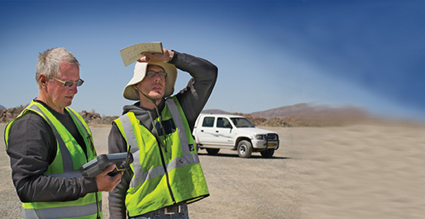
    Locata Corporation announced today that its integration partner, Leica Geosystems Mining, has begun to sell — and ship to their global mining customers — a Locata-powered positioning systems that it calls “the world’s first.”

    The Leica Jps (the Jigsaw Positioning System powered by Locata) integrates GNSS and Locata’s ground-based GPS-like networks. The result is a seamless and a completely new “GPS everywhere” experience for Leica’s customers, the company said. This new capability is now in use at Newmont’s Boddington Gold Mine, northwest of Boddington, Western Australia. The mine has published an independent article describing the LocataNet and Jps systems deployed for the mine’s drill rig fleet. It reported that drill rig up-time and efficiency have skyrocketed to unprecedented levels since the Jps system was commissioned.

    Locata-enabled nonstop positioning brings benefits to machine automation in mining because Locata fills in the many gaps in GPS signal availability experienced in an open-cut mine, Leica said. The Leica Jps ensures a reliable and transparent experience for users with demanding machine guidance applications because it uses all available signals, satellite-based or Locata, without interruption.

    “The Locata-based Jps is therefore the world’s first system which can justly be considered as ‘a backup for GPS’,” reads a Leica Geosystems statement. “Real-world operational performance, which is being reported by Jps customers, can only be described as ‘spectacular’.”

    “Since deploying the Locata-powered Jps at Newmont Boddington Gold, there has been an increase in operational machine guidance availability of almost 23 percent – from 75 percent up to 98 percent,” said Brendon Lilly, product manager, Leica Geosystems Mining. “Newmont Boddington Gold is so happy with the results that they have turned off their GPS-only solutions altogether, and now rely solely (and successfully) on Jps alone. They have already installed Jps on 11 drills and intend to equip their entire high-precision fleet.”

    “The ROI we offer our clients through the Jigsaw Positioning System is extraordinary. Market trends indicate CAPEX is in decline, so the parameters mines use to justify expenditure have become far more demanding,” said Stefana Vella, global marketing manager, Leica Geosystems Mining. “The unprecedented production levels and machine control uptime that result directly from using the Locata-powered Jps very quickly justifies the purchase of the system. Furthermore, it aids the justification of expenditure on the high-precision machine guidance systems themselves, for, when operated with the Jps, the ROI increases exponentially. Even in today’s market, it isn’t a difficult decision to make.”

    Many mines around the world use machine guidance systems for drills, shovels, excavators, dozers, graders and more to execute the site plan work in real-time. This tight automation dramatically improves efficiency and productivity. At the core of these machine guidance systems are GPS-style receivers that provide vital positioning information, using the satellite signals to calculate a 3D position.

    Unfortunately, in most open-pit environments satellite signals become obstructed, which slows or temporarily halts production. As pits become deeper the problems become worse, drastically reducing the number of satellites the receiver can “see” to achieve GPS-style positioning. In the past, mines and other machine automation users had no choice other than to resort to much less efficient alternatives, such as manual surveying. Reduced satellite visibility therefore negated the considerable investment and operational efficiencies gained from modern machine guidance systems. The key to virtually eliminate these issues is Locata’s new “GPS-backup or replacement” capability, Leica Geosystems said.

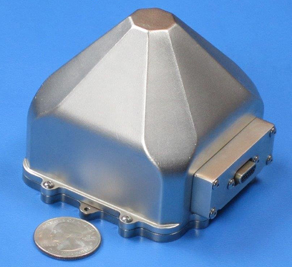
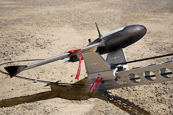
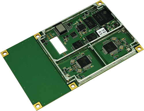
    Locata’s Locatalite device is a ground-based transmitter that generates a GPS-like signal. LocataLites deployed around the pit rim can ensure almost 100 percent positioning coverage. Locata signals “fill-in” the GPS holes with a signal that is processed by the Jps in exactly the same way that GPS signals are. Locata is the only technology in the world that can do this. By backing up their GPS-based systems, mines have an always-on positioning network that works if satellite signals are unavailable in the pit due to physical or man-made obstructions. Jps LocataLites can be permanently positioned on site or moved at will, ensuring a mine’s Jps Locata network can be set up where and when needed.

    “We all rely on electricity from public sources, but in areas where outages occur companies invest in backup generators,” said Nunzio Gambale, CEO and co-founder of Locata. “It’s exactly the same scenario for mining companies, where they are dependent on GPS. Locata gives you a GPS backup ‘generator’ – a world-first capability which is clearly a game-changer for the whole industry. Before Locata became available mines simply had to suffer through a slow-down when GPS-based systems became flaky. Leica Geosystems had the vision early on to recognize the enormous benefits provided by our technology advancements. They threw their corporate weight behind intensive product development, carefully integrating Locata technology into their world-first Jigsaw mining solutions. It’s a marriage made in heaven, and Jps customers will be the ones who really reap the rewards of Leica’s outstanding first-mover effort. There won’t be any ‘GPS doesn’t work here’ excuses in the future.”

    John Carr, senior technical specialist at Newmont Boddington Gold Mine, puts it this way: “Look, it’s really this simple. If Locata had not invented the technology to help fix the GPS issues in a deep pit scenario I may as well have gone back home, started breeding pit ponies and sharpened up the picks and shovels… Open Cut Mines, just like everyone else that depends heavily on satellite navigation, are already hitting the wall at the outer limits of GPS technology. With Locata, we’ve virtually eliminated everyday GNSS signal challenges. And now we also have our own backup in place in case of a more significant or longer-term failure.”

  • Hemisphere GPS Offers Vector Compass Products for Marine Applications

    Photo: Hemisphere
    Photo: Hemisphere

    Today, Hemisphere GPS introduces the Vector VS330 and Vector VS131 GPS compass products that provide high performance heading, position, heave, and attitude data. The new Vector products are designed for professional marine applications such as hydrographic and bathymetric surveys, dredging, oil platform positioning, and buoys that demand a high level of 3D positioning accuracies.

    Based on Hemisphere GPS’ Eclipse GNSS technology, Vector VS330 uses the most accurate differential corrections including RTK, L-band, SBAS, and beacon. The smart intelligence from our MFA firmware  provides differential solutions by automatically switching to the next best differential source if the original source is no longer available, Hemisphere GPS said.

    Vector VS330 is Hemisphere GPS’ flagship receiver and computes heading information with better than 0.01 degrees accuracy when using a 10-meter antenna separation. Positioning accuracy is better than one centimeter in RTK mode or four centimeters when using OmniSTAR HP corrections. Vector VS330 also provides five-centimeter RTK heave and 0.01 degree pitch and roll accuracies.

    Combining Hemisphere GPS’ Crescent Vector and LX-2 receivers with two separate antennas, the Vector VS131 computes heading information with better than 0.03 degrees accuracy when using a five-meter antenna separation and better than 50 centimeter position accuracy when using L-band, SBAS, or beacon corrections. Vector VS131 accepts most differential correction signals for unparalleled flexibility to obtain sub-meter positioning in all regions.

    The ruggedness of the new Vector enclosure also makes it suitable for more harsh environment installations like machine-control applications, including agriculture, heavy construction equipment, mining equipment, unmanned vehicles, cranes, and other machinery or industries that require very accurate heading and positioning solutions. The Vector’s versatility for providing heading, position, heave, and motion makes it directly compatible with the most popular hydrographic and side scan survey packages. Vector VS330 and VS131 include an intuitive and easy-to-follow user interface to facilitate fast installations.

    “Vector VS330 and Vector VS131 are premium additions to Hemisphere GPS’ Vector series product line,” said Phil Gabriel, vice president and general manager, Precision Products, for Hemisphere GPS. “As the demand for more rugged and precise GPS equipment increases, we are meeting this demand by exceeding the accuracy of competitors’ products while being significantly more affordable.”

    Vector VS330 and Vector VS131 will be featured by Hemisphere GPS in hall 9, stand B.62 at the INTERGEO Conference and Trade Fair in Hanover, Germany, from October 9-11. Both products will be available for shipping in November through the Hemisphere GPS Precision Products global dealer network.