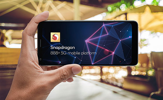
Upgraded flagship mobile platform to power commercial smartphones from ASUS, Honor, Motorola, vivo and Xiaomi in second half of 2021
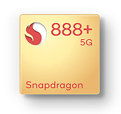
Photo: Qualcomm
Qualcomm Technologies Inc. announced the Snapdragon 888 Plus 5G Mobile Platform, a follow-on to the flagship Snapdragon 888. These two platforms power more than 130 designs announced or in development. The product was introduced at Mobile World Congress, taking place this week in Barcelona, Spain.
Satellite systems supported include all four constellations (GPS, Beidou, Galileo, GLONASS) with dual-frequency GNSS. Additional systems supported include NavIC, QZSS and SBAS.
Snapdragon 888 Plus provides AI-enhanced gameplay, streaming, photography and premium connectivity. Compared to its predecessor, Snapdragon 888 Plus offers an increased Qualcomm Kryo 680 CPU Prime core clock speed at up to 3.0 GHz and the 6th generation Qualcomm AI Engine with up to 32 TOPS AI performance, which is more than 20% improvement.
“Snapdragon is synonymous with premium Android experiences. Our latest flagship Snapdragon 888 Plus 5G Mobile Platform will help deliver the premium entertainment, connectivity, and gaming experiences users deserve,” said Christopher Patrick, senior vice president and general manager, mobile handset business, Qualcomm. “We’re excited to see OEMs launch with products based on our highest performing platform.”
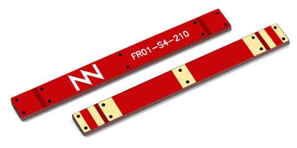
Fractus Antennas has launched a mobile antenna that enables coverage at 3G, 4G and 5G — the TRIO mXTEND chip antenna component.
The TRIO mXTEND has been specifically designed to provide flexibility to operate any required frequency band inside any wireless device.
It is capable of operating the main mobile communication standards, enabling worldwide coverage, as well as GNSS such as GPS, GLONASS and BeiDou (1561 MHz, 1575 MHz and 1598-1606 MHz) and the main short range wireless bands such as Bluetooth and Wi-Fi (2400-2500MHz and 4900-5875MHz) through the same antenna component.
The TRIO mXTEND is a modular, multiband and multi-port antenna component that enables top-quality worldwide coverage at any mobile communication standard. Its reconfigurable and off-the-shelf nature allows multiple architectures so the antenna component can be assembled into any mobile or IoT device.
It has been designed for providing mobile operation in three different frequency regions: 698-960 MHz, 1710-2690 MHz and 3400-3800 MHz. In addition, TRIO mXTEND is presented in an ultra slim component of 1 millimeter that enables easy placement into any device.
The Fractus Antennas team will be at Mobile World Congress in Barcelona, either at the venue or in Fractus Antennas Headquarters, which is based in the city. Those interested are invited to arrange a meeting.
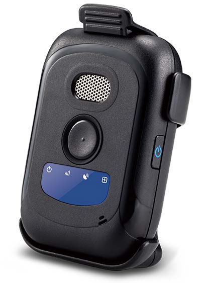
Winter weather can make fieldwork more dangerous. If a worker falls off a structure, becomes trapped or is otherwise incapacitated, in a remote location or working alone, he or she could be without aid for hours.
The Mobile Defender Model-S (MD-S) by SecuraTrac is designed to monitor field workers and provide alerts to keep them safe. It provides global GPS services and is able to withstand extreme conditions and uses.
In an emergency situation, taking out a cell phone or tablet to make a call or send a message is not always possible.
The MD-S monitors worker status and can immediately call for help if a problem is detected. The worker can also press a button to be connected to responders.
The MD-S features SecuraTrac’s new fall advisory capability and more than 30 days of battery life on a single charge, the company said.
BeiDou Signals, Future Receiver Design Highlighted at Stanford PNT Symposium
By James D. Litton and Tom Langenstein
James L. Litton
The Stanford Center for Position, Navigation and Time conducted its eighth symposium on PNT in October 2014. These symposia have always been a superb two (this year three) days of excellent presentations, ranging over the entire domain of PNT, including policy factors as well as technical ones.
This year the first day featured student speakers, either from Stanford or the students of former Stanford students who are now faculty at other universities. The conference is by invitation only; sponsors include Lockheed Martin, Boeing, and other companies involved with GNSS. This essay highlights two presentations that struck us as harbingers of change in the industry: Greg Turetzky’s paper on ubiquitous location, and Minquan Lu’s and Zheng Yao’s paper on new signal structures for BeiDou.
Brad Parkinson gave a keynote address mixing challenges and opportunities from the frontiers of policy formation. David Last did not fail to amuse with his lighthearted and satirical commentary on navigation and society at dinner. Many others gave noteworthy presentations, and all of the presentation slides can be found online.
Tom Langenstein
Both papers that we selected for this article have very broad scope with considerable strategic significance in GNSS design and applications. It seems a little impertinent, as well as superficial, to try to convey their essence in fewer than 2,000 words, but the material presented is available elsewhere, too.
New Signal Structures for BeiDou
Professors Mingquan Lu and Zheng Yao of Tsinghua University laid out in clear and detailed fashion the motivations for BeiDou’s choosing to introduce new signals for the Phase III global system, analyses of alternative modulations, and the results of bench testing in service to the desired properties (interoperability, acquisition and tracking thresholds, receiver complexity, in-band interference, and so on).
They emphasized one non-technical or operational motivation: independent proprietary designs for patent protection. No declaration of policy intention was made; however, the direction was clear, even though the authors are university professors and not government officials.
Some of this work has been published elsewhere in IEEETransactions by the same authors and has a substantial history, reflecting the lessons learned from the predecessor system designs and very thorough analysis, simulation and bench testing. Space does not allow extensive citation, but the key drivers for the designs and the results are summarized below. The preferred modulations chosen or synthesized are quadrature multiplexed binary offset carrier (QMBOC) for B1C and asymmetric constant envelope-binary offset carrier (ACE-BOC).
The principal deficiencies cited of the earlier-proposed BeiDou Phase III signals (circa 2010-ICG) were given as:
no independent intellectual property rights; thus, a big patent risk
signal performance needs to be improved
more flexible receiving modes and more varied application scenarios should be considered.
The principal requirements for BeiDou Open Service signals were cited as:
independent intellectual property rights
better compatibility and interoperability with GPS and Galileo
smooth transition from Phase II to Phase III
improved performance
Separate requirements were stated for the B1C and B2 signals, as follows:
B1C: (QMBOC)
compatibility with other signals of the same carrier frequency
better interoperability with GPS L1 and Galileo E1 signals
better ranging accuracy (than GPS C/A and BeiDou Phase II B1(I))
receiving mode diversity for different receivers (low-end and high-end)
independent Intellectual property rights
B2C: (ACE-BOC)
multiplexed B2a and B2b into a constant envelope signal
better interoperability with the GPS L5 and GALILEO E5 signals
In the quoted case study tests, simulated ACE-BOC and AltBOC signals were generated at several fixed transmitting power levels and processed using software receivers. For each given transmit power level, the ACE-BOC was allotted three times power for the pilot channel over that of the data channel while the AltBOC allocated equal amount of power for both the pilot and the data channel, that is, 3:1 for ACE-BOC and 1:1 for AltBOC.
The resulting tracking performance of the ACE-BOC is more robust than that of the AltBOC.
Table 1, taken from the presentation, provides an overview of the signals.
Table 1. New signal structures proposed for BeiDou.
The compatibility properties of the new signals, if adopted, which seems quite likely, are desirable. The implicit intellectual property aspects of the development, both in motivation and in differential design of a signal structure which seems to be claimed as novel have a defensive basis, apparently, in earlier assertions of proprietary designs. It will be interesting to see whether similar international negotiations follow, or perhaps already have. The paper was well received and stimulated considerable hallway comment.
Ubiquitous Location
Turetzky’s paper laid out the phenomenal growth of location-based services and the implications of such growth for design requirements in GNSS-wireless at the user device level and at the silicon level. On growth (from various quoted sources):
The compound annual growth rate of GNSS devices will continue, from its current 22 percent level to a robust 9 percent for the years 2016-2022; heading for seven billion installed units by 2022.
The cumulative core revenue in the decade 2012-2022 will be 46 percent in LBS portable and wearable devices and 47+ percent in vehicles.
There will be many billions of installations of indoor location technologies by 2018, in virtually every venue imaginable.
Some of the design implications of the requirements driving the growth in indoor location are:
Always Located, or continuous location. For this case, the energy dissipated per day (16 hours) and signal availability (100 percent) are the featured specification and the secondary specification, respectively. These specifications, in turn, require hybrid constellations and minimal standby power consumption.
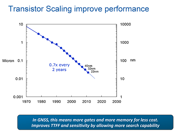
The scaling down to very small (14 nanometer) dimensions enables much faster switching speeds, search rates and lower power dissipation in active modes and more complex algorithms, but at the expense of leakage current, which adversely affects standby power, an increasingly important factor.
Thus, for GNSS design, the challenges are to:
Take advantage of benefits of smaller geometries to achieve higher clock speeds, more memory, lower active power and smaller size, while greatly reducing standby power from leakage;
Incorporate new methodologies at chip and system design level; Integrate multiple radios on a single die to reduce cost and size without creating interference to a very sensitive GNSS radio;
Integrate multiple radio sources into a single location solution;
Bring together a disparate value chain;
Turetzky outlined a vision for his employer, Intel, to be a leader in all aspects of these revolutionary developments. The technology roadmaps embrace most modalities of positioning: GNSS, Bluetooth, WI-Fi, cellular, and SBAS, and cross most platforms, including wearables. We think that another, unemphasized challenge is in the increasing density of these units with the current specifications on out-of-band-emissions and the spectrum sharing and spectrum management factors in the ubiquity of the devices.
From Greg Turetzky’s Ubiquitous Location paper, presented at Stanford PNT Symposium.
Tune in to our free webinar Receiver Design for the Future,with Greg Turetzky of Stanford speaking on Ubiquitous Location, scheduled for Jan. 15 (1 p.m. EST/ 10 a.m. PST/ 6 p.m. GMT). Register today!
Both papers represented the dynamism of our industry and its diversity of technologies and practitioners and the service to that industry provided by the remarkably consistent excellence of this symposium.
James D. Litton heads the Litton Consulting Group and previously played key executive roles at NavCom Technology and Magnavox.
Tom Langenstein is executive director of the Stanford Center for Position, Navigation, and Time, and deputy program manager of the Gravity Probe-B project.
Bartec Pixavihas launched the “Impact X intrinsically safe smartphone” based on u-blox’ rugged 3G cellular module technology designed for devices used in tough industrial and outdoor environments. Bartec Pixavi is a manufacturer of mobile devices used in hazardous or explosive environments such as oil platforms, mines and chemical plants.
“Our Impact X smartphone is designed with the most robust, reliable and safe components available to ensure security and provide reliable connectivity to workers in potentially dangerous locations,” said Christian Rokseth, CEO of Bartec Pixavi. “We chose u-blox’ cellular module technology because of its industry-leading performance, excellent environmental tolerance and reliability.”
u-blox LISA u230 module. Photo: u-blox
The Impact X is CSA Class 1, Zone 1, IECEx and ATEX Zone 1 certified, explosion proof, waterproof and extremely ruggedized. At the heart of the Impact X is u-blox’ professional-grade LISA-U230 six-band 3G cellular module with 2G fallback capability. LISA modules also provide fully integrated access to u-blox GNSS receivers to enable advanced location-aware applications. Antenna diversity permits LISA-U2 modules to provide the highest data speeds.
“The Impact X is an excellent example of a high-performance mobile device that demands performance well beyond what is provided by standard mobile phones,” said Armin Boeshenz, General Manager of u‑blox sales EMEA. “We are extremely pleased to be a key module supplier to demanding customers such as Bartec Pixavi as proof of our industry-leading quality and reliability.”
u-blox LISA-U2 modules are suited for networks worldwide. Features include data-rates of up to 21.1 Mb/s (downlink), a rich set of Internet protocols, very small footprint, very low power consumption and extended operating temperature range of -40 to +85 degrees C.
Jerker Hellström, founder and CEO of Handheld Group.
Jerker Hellström, founder and CEO of Handheld Group, has identified three key trends in mobile computing in 2015. Handheld is a maker of rugged computers for professionals.
His predictions:
1.Larger displays even for rugged mobile computers.
“Rugged laptops, tablets, PDAs and smartphones continue to be the fastest growing market mobile computer segment, and just like the screen size of smartphones for the mass market has increased, so will the displays of rugged computers. Screen size is the “$64,000 question” in the rugged computer segment — it is a major consideration for all users, but it is also linked to the application and how data and information are presented, both in terms of how it is captured and how it is communicated to the end user. I foresee a stronger demand for maximum screen real-estate in the smallest, lightest possible form factor. (One real-life example would be the recently launched Nautiz X8 by Handheld with a huge 4.7-inch display for an IP67-rated rugged device).”
2.Higher IP ratings.
“Mobile computers across all market segments are increasingly being manufactured, and marketed, as more durable, more rugged and with higher IP ratings (ingress protection against water and dust).This a function of computers, tablets and smartphones being with us all the time, everywhere. The consumers demand durable devices that can be knocked around a bit! But it has also become a marketing gimmick. Some devices are now advertized as having the previously unattainable IP68 rating. But do the customers actually understand it? It actually means nothing unless the manufacturer informs us of the submerged time and depth. I expect a continued upwards ‘IP rating creep’ but also an invigorating discussion about the definition and value of IP ratings and the tests carried out on mobile computers.”
3.Increasing interest for Android.
“Microsoft Windows Mobile or Windows Embedded has for a long time been the operative system of choice for rugged mobile devices, albeit with increasingly stronger competition from Android. 2015 will be the year when he industry truly embraces Android. The rapid growing of Android consumer phones has standardized the Android user behavior and generated a spillover effect to the industrial sector. There is an increase of industrial software being developed for Android, boosted by the first generation industrial Android devices. Also, Android can take advantage of powerful multicore CPUs in a way Windows Embedded Handheld has not been able to.“
The Nautix X8 rugged Android handheld.
Jerker Hellström is the founder and CEO of Handheld, a manufacturer of rugged mobile computers, PDAs and smartphones.Heis a pioneer and industry veteran in the mobile rugged computer industry. In both entrepreneurial and managerial positions, he has more than 25 years of experience from developing, designing, manufacturing and marketing rugged computers globally. Jerker´s educational background is in engineering and computer science.
The new NEO-M8L Automotive Dead Reckoning (ADR) module by u-blox has integrated motion, direction and elevation sensors. The module integrates gyro and accelerometer with u‑blox’ GNSS platform u-blox M8 to achieve high indoor/outdoor positioning performance for road vehicle and high-accuracy navigation applications.
In addition to accessing the integrated module’s gyro and accelerometer data, accident reconstruction systems can provide the location of an accident to facilitate insurance claims even if a collision occurs in a tunnel or park house. High-end navigation devices are able to guide drivers through tunnels of several kilometers because of the accuracy of u-blox’ ADR system. Stolen vehicles can be located instantly due to continuous monitoring of sensor data and storage of location in non-volatile memory.
“Devices for usage-based insurance, stolen vehicle recovery, road pricing, fleet management, emergency services, and vehicle navigation depend on reliable, uninterrupted positioning including tunnels, park houses and stacked highways,” said Thomas Nigg, vice president of product strategy at u-blox. “The NEO-M8L is the ideal solution for all road vehicle based applications, able to calculate a position in all circumstances based on its own internal sensors, regardless of satellite visibility and end-device orientation.”
The NEO-M8L module will be demonstrated at the u-blox stand at electronica 2014 in Munich, November 11-14, Hall A4 Stand 219.
The compact module is 12.2 x 16.0 x 2.5 mm, requires minimum host integration resulting in no risk, is low cost, and provides fast time-to-market design, u-blox said. With uncritical orientation of the installed module, odometer function and autonomous data logging, it is an all-in-one solution for all road vehicle applications requiring reliable and uninterrupted position in challenging environments such as urban canyons, tunnels and underground parking.
The NEO-M8L embeds u-blox’ 3D Automotive Dead Reckoning (3D ADR) chip technology. Using the vehicle’s speed information and the module’s onboard sensors enables accurate positioning in three dimensions, even when satellite signals are completely lost and the end-device installation is not horizontal, u-blox said. An odometer function, based on the ADR technology, also provides accurate and continuous distance traveled.
The module is able to track all visible GNSS satellites including GPS, GLONASS, BeiDou, QZSS and all SBAS (European’s Galileo will be supported in a future firmware version). Concurrent reception of two GNSS systems is supported. The NEO-M8L module can output a position up to 20 times per second.
The module uses u‑blox’ M8 GNSS chip and is available in Professional Product grade. This grade includes qualification according to the ISO16750 standard “Road vehicles — Environmental conditions and testing for electrical and electronic equipment” and manufacturing in ISO/TS 16949 automotive-certified factories.
Samples and evaluation kits will be available in December 2014.
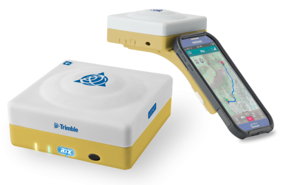
The Trimble Leap, also shown with a smartphone. Photo: Trimble
Trimble is making available the Trimble Leap, a Trimble RTX compatible GNSS Bluetooth device. When enabled with the ViewPoint RTX correction service, Leap delivers submeter accuracy directly to the Terrain Navigator Pro (TNP) Mobile app for iOS and Android devices. The TNP Mobile app allows users to collect markers, tracks and geo-stamped photos in the field, and then sync all the GNSS data into the Terrain Navigator Pro office software.
The TNP Mobile app enables users to:
Display and navigate routes created in TNP desktop.
Collect field data such as markers, tracks, photos, videos and audio clips.
Near real-time sync between phone and TNP map software via WiFi or cellular data connection.
View data on topo, aerial, and street maps downloaded to phone for offline use. Terrain Navigator Pro offers 1-meter aerial photos for the 48 contiguous United States. The seamless USGS topo graphic maps are based off 1:24K, 1:100K, 1:250K map scales. Alaska is 1:63K and 1:250K.
Access a compass and other geo-information such as lat/long, elevation, and direction on phone.
Collect data offline. The TNP mobile app uses the GPS built into the smartphones, so users can collect field data in areas without a cellular or data signal.
Trimble Leap is compact and portable, weighing 9.5 ounces. It snaps to a smartphone or tablet to use as a handheld, can be mounted on a monopole or tripod, or can be magnet mounted to a vehicle. Leap has 16 hours of battery life and uses Bluetooth communication to connect to smart devices for ease of use and flexibility. An onboard micro SD card stores the GNSS observables data for use in the field or the office.
A micro USB port can provide power to Trimble Leap for continuous fixed-mount applications, or it can be used with battery-booster products to extend field work. Trimble Leap is charged by a standard cell phone vehicle accessory charger, a USB connection to a PC, or from a USB AC adapter.
Based on Trimble RTX (Real Time eXtended) technology, ViewPoint RTX delivers better than 1 meter horizontal accuracy 95 percent of the time without the use of a traditional RTK base station or virtual reference station network. ViewPoint RTX is delivered into the TNP Mobile app via cellular data network and is available nearly anywhere in the world.
“Trimble Leap enhances the Terrain Navigator Pro solution by adding a simple way to collect submeter accurate geolocation data with standard Android or iOS devices. Adding accuracy to TNP’s robust field-to-office data collection solution provides a value-add where low-resolution collection is not sufficient. Trimble Leap with TNP Mobile is configured and operational in minutes with little training,” said Larry Fox, business area manager for Terrain Navigator Pro.
Terrain Navigator Pro integrates powerful desktop mapping software, a cloud connected mobile data collection platform (compatible with GPS-enabled iOS and Android devices) and a robust Web portal. TNP users can plan projects in the office, collect data in the field and access projects from the Web—simultaneously. Geo-referenced data such as tracks, waypoints, photographs and video can be shared, updated in near real-time and displayed on the included topographic, aerial/satellite or street base maps.
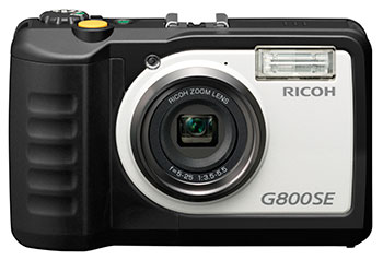
Ricoh Americas Corporation has made major improvements to its water-, dust- and shock-resistant G800 camera. The G800SE model includes GPS and a barcode-reading capability that helps streamline workflows across a wide range of industries.
The new Wi-Fi- and Bluetooth-enabled Ricoh G800SE allows for dynamic information capture in industries such as automotive, logistics, government, healthcare, emergency services and more. For example, a car dealership can scan the barcode on a new car, photograph the vehicle, and have the photograph and vehicle information flow directly to the dealership website for customers to see. This new workflow saves hours of painstaking information retrieval and organization, Ricoh said. With a standard camera, clerks would need to manually match images to each car, introducing the possibility of error at every step.
“By embedding critical data into images, the Ricoh G800SE epitomizes information mobility, the ability for employees to access just the information they need in the form they need it to make important decisions,” said Matt Sakauchi, vice president, Technology Marketing, Ricoh Americas Corporation. “This is just one way we’re making customers’ business information work for them in this new world of work.”
The Ricoh G800SE includes a host of upgrades over the previous generation of ruggedized Ricoh wireless-enabled camera, the Ricoh G700SE. For example, a higher-resolution image sensor provides a new ability to capture images under low-light conditions. The Ricoh G800SE also takes advantage of higher wireless transmission speeds and the more secure “enterprise” Wi-Fi increasingly seen in healthcare facilities and government agencies. It leverages the Protected Extensible Authentication Protocol (PEAP), an emerging standard in enterprise wireless security.
A flexible password lock feature enables organizations to create separate passwords for administrators and users with each one unlocking different sets of permissions. A smartphone connection enables users to remotely operate the camera via their mobile devices. Using a smartphone or tablet, they can preview, zoom, shoot and capture image data, including GPS position. The capability is also intended for surveillance applications.
Organizations can manage fleets of Ricoh G800SE cameras via remote management software with the ability to upgrade firmware, adjust camera settings and update memo functions. An alternative for camera configuration is distributing SD cards with prescribed settings.
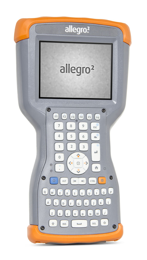
The Allegro 2 by Juniper Systems. Photo: Juniper Systems
Juniper Systems announced its newest rugged handheld computer, the Allegro 2, at the InterGeo 2014 trade show, held September 7-9 in Berlin. The handheld is the latest in the company’s Allegro product line, “with every bit of reliability,” the company says, but now with some major advancements.
According to Juniper Systems, the Allegro 2 was designed for data-intensive applications, with meticulous attention paid to the engineering and design of the handheld to maximize efficiency and precision, both of which are critically important to high-volume data collection.
Compared to the Allegro 1, the Allegro 2 has a newly designed keyboard in a QWERTY and numeric layout, with large, glove-friendly buttons for rapid — even non-visual — data entry. The new handheld features a custom Sun-to-Shade display that is 20 percent larger than the previous Allegro. It offers excellent visibility in any lighting conditions, the company said.
The Allegro 2 is powered by an Overtime Technology battery, providing a 20+ hours of runtime. Its touchscreen uses capacitive technology, providing excellent durability, as well as crystal-clear imagery and greater sensitivity to touch, Juniper Systems said. The Allegro 2 has significantly enhanced GNSS performance, extended Bluetooth range, camera and video options, and a more powerful processor than the Allegro 1.
“The Allegro 2 is our next-generation product, and it includes all of the latest enhancements available in its sister product, the Archer 2,” said John Florio, product manager at Juniper Systems. “The Allegro 2 was built from the ground up, based on user feedback on the jobs they have to do. Whether the customer is grading lumber in a log scaling yard, running a robotic total station, or performing a close-interval pipeline survey, the Allegro 2 is the best solution for the field today.”
The Allegro 2 is scheduled to begin shipping in November.
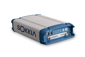
Sokkia announces the latest addition to its line of geodetic GNSS reference receivers — the GNR5. Making use of 452 channels optimized to track the full GNSS spectrum, the GNR5 is designed to assign any visible signal to any available receiver channel.
“The GNR5 is a comprehensive connectivity solution,” said Charles Rihner, vice president of the GeoPositioning Group. “Whether using the built-in Bluetooth and Wi-Fi wireless communication options, or standard Ethernet, serial and USB connections — the system provides a powerfully integrated reference station that is capable of tracking the GPS, GLONASS, Galileo, Beidou, QZSS and SBAS constellations.”
Additional features include high-precision code and carrier phase measurements up to 100 Hz, Power over Ethernet (PoE), and advanced receiver management features.
The new receiver is on display at InterGeo 2014, being held this week in Berlin.
Trimble has introduced additions to its GNSS portfolio — the Trimble NetR9 Geospatial receiver; the Trimble Geo7X with Trimble Access field software onboard; and enhanced Trimble xFill functionality that provides continuous RTK level accuracy when paired with a Trimble CenterPoint RTX subscription. The new additions offer surveyors more flexibility in the field to meet a variety of work requirements.
The announcement was made today at InterGeo 2014, the world’s largest conference on geodesy, geoinformatics and land management.
The Trimble NetR9 Geospatial GNSS Receiver. Photo: Trimble
Trimble NetR9 Geospatial GNSS Receiver. The Trimble NetR9 Geospatial has been configured as a comprehensive modular GNSS receiver for the professional survey market. The lightweight form factor of the NetR9 comes fully loaded with performance enhancements including: Trimble HD-GNSS technology, Trimble 360 technology, Trimble CenterPoint RTX correction service support and Trimble xFill technology. The combination of these capabilities provide a powerful solution that delivers accurate positioning and support for all existing and currently planned GNSS constellations, and continuous RTK-level precision during interruptions of the primary correction source, Trimble said.
Serving as either a rover or mobile base station, the NetR9 Geospatial offers the flexibility to choose a GNSS antenna and radio solution that matches the surveyor’s specific workflow needs. “Trimble’s GNSS solutions are designed to meet the unique requirements of surveyors,” said Elmar Lenz, business area director of GNSS Solutions for Trimble’s Geospatial GNSS Division. “These solutions provide professionals in the survey and engineering industry with flexible tools to stay productive and competitive, delivering the appropriate solution for any survey project that’s being completed, no matter where our customers work and survey.”
Trimble Geo 7X with Trimble Access. Designed for surveyors facing a variety of workflow requirements to accomplish both high-accuracy surveying and handheld point measurement, the Geo7X is now available with Trimble Access field software onboard. With Trimble Access onboard the Geo7X, surveyors benefit from a familiar, easy-to-use software interface that provides common survey workflows directly on their GNSS handheld, resulting in increased data collection efficiency.
The Geo7X is a dedicated network rover that can be used on a survey rod with an external antenna for survey-grade accuracy. If the surveyor prefers the convenience of a highly mobile handheld solution, they can snap if off the rod and switch to the internal antenna. In this mode, they also have easier access to other features such as the integrated camera for collecting attribute data.
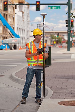
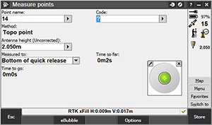
Trimble xFill in use. Photo: Trimble
Expanded Trimble xFill Functionality. Expanded xFill functionality, available in the Trimble R10 GNSS receiver and NetR9 Geospatial receiver, allows surveyors to continue collecting data with centimeter accuracy indefinitely throughout their workday when the connection to the base station or VRS network is lost. The expanded xFill functionality is enabled via a CenterPoint RTX subscription.
Without a Trimble CenterPoint RTX subscription, xFill maintains RTK level accuracy for up to five minutes during interruptions in the primary terrestrial correction stream. This basic xFill functionality is included with the Timble R10 GNSS system and is now included with the NetR9 Geospatial GNSS receiver.
“With expanded accuracy levels and seamless RTK/RTX transition, the Trimble R10 continues to offer unprecedented capability to the survey professional,” said Lenz. “Connectivity problems are traditionally one of the biggest GNSS-related challenges a surveyor will face while in the field and expanded Trimble xFill functionality significantly helps solve that problem, saving time and money.”