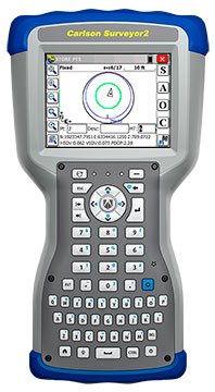
The Carlson Surveyor2, the newest model of Carlson Software’s Carlson Surveyor line of data collectors, was launched at the InterGeo Trade Show in Berlin this week.
The handheld surveyor is on display at Carlson’s Stand 1.037, Hall 1.1, at InterGeo.
Fast, durable and more powerful, the Carlson Surveyor2 is ruggedized, with an IP68 water and dust-resistant ingress rating. Still weighing two pounds, the Carlson Surveyor2 offers increased program memory (now 512MB) and increased non-volatile data storage (now 8 gigabytes), and a 1.0-GHz processor to provide the speed surveyors need in the field. It comes equipped with significantly increased Bluetooth range, up to 1500 feet when paired with a class I device.
The Surveyor2’s QWERTY keyboard eases data entry and is designed to be workable even for those with large hands or wearing gloves. The backlit keys and larger, brighter display screen allow users to work effectively in all lighting conditions.
“Not only did the Surveyor2 retain the durability of its predecessor, but its higher-resolution, easier-to-read display screen also comes with scratch-resistant glass,” said Bruce Carlson, president and founder of Carlson Software. “An added convenience is its enhanced battery life — up to 20 hours.”
The Surveyor2 has kept its easy-to-grip design, being thinner front to back than other data collectors when resting on a table top. The computer runs on Windows Mobile 6.5.3 and Carlson SurvCE 4.0 can be included. SurvCE is the powerful data collection software used around the world.
The Surveyor2 is designed for surveying, stake out, construction layout and GIS mapping. The easy-to-use, tab-based menu and advanced graphics in Carlson SurvCE 4.0 enhance the Carlson Surveyor2’s usability. Options include an integrated GSM cell modem for real-time connectivity, an integrated 5 MP camera with LED illuminator that doubles as flashlight, and a mapping-grade GNSS receiver.
The upcoming Telematics Munich conference, scheduled for November 10-11 at the Hotel Dolce Munich, is considered Europe’s largest and most influential business conference and exhibition for the connected car industry.
More than 1,000 industry executives and 100 speakers are set to attend the conference, which has the theme “The Car Plugs into the Connected World: Auto Mobility Strategies for 2020.”
This year’s agenda covers these topics:
Personalized Connectivity Prevails — Context is king as data from changing driving environments sync with personal preferences to create a UX that bridges generational gaps.
Data Investments Pay Out —Collect. Analyze. Deliver. Harness connected car data to obtain real consumer and vehicle insights and generate new revenues.
Move with the M2M Hype Curve —Align the tech of other connected industries (such as home automation and health) with the car to draw closer to a totally connected lifestyle.
Tech Titans Enter The Connected Car —Discuss the business model and CRM repercussions for entrenched telematics players as CE giants move into the ecosystem.
Auto Mobility Towards 2020 — Debate OEM commitments, V2X tech, and smart cities today to plot the path of automated vehicle technology of tomorrow.
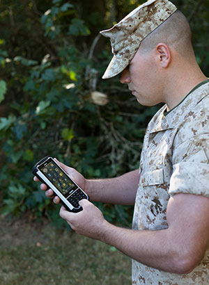
Handheld Group, a manufacturer of rugged mobile computers, has launched the Nautiz X8 rugged PDA. The Nautiz X8 is a handheld computer with superior processing power, screen performance and battery life, the company said. It is built for tough field conditions primarily in GIS, land surveying, public safety, forestry and the military.
Photo: Handheld Group
The Nautiz X8 is built to enable efficient and reliable data collection in tough environments. It has an IP67 ingress protection rating, which means it offers complete protection against dust and sand and can withstand immersion in water. It also meets stringent MIL-STD-810G military test standards for overall durability and resistance to humidity, shock, vibration, drops, salt and extreme temperatures.
The Nautiz X8 features a high-performance Texas Instruments 4470 dual-core 1.5 GHz processor. It has 1 GB of RAM, 4 GB of iNAND Flash and a 5200 mAh Li-ion battery that lasts up to 12 hours on a single charge. It comes with a choice of operating systems — Android 4.2.2 or Windows Embedded Handheld 6.5.3.
The device has a large 4.7-inch ultra-bright capacitive multi-touch screen with chemically strengthened Asahi Dragontrail glass, offering users brightness and protection in any field condition. The unit has an ergonomic design and weighs 490 grams (17.3 ounces).
The Nautiz X8 has a dedicated u-blox GPS receiver, Bluetooth 2.0 and 802.11b/g/n WLAN functionality, as well as connectivity through GSM/UMTS or CDMA phone data transmission. A built-in 8-megapixel camera with autofocus and an LED flash lets users capture visual data quickly and easily. This handheld also features an open architecture and an extension cap system that allows for additional hardware connections such as sensors, radios and other add-ons.
Orders for the new Nautiz X8 can be placed immediately. First deliveries will begin in November.
The Nautiz X8 rugged handheld will be shown first at WEFTEC in New Orleans, followed by InterGeo in Berlin.
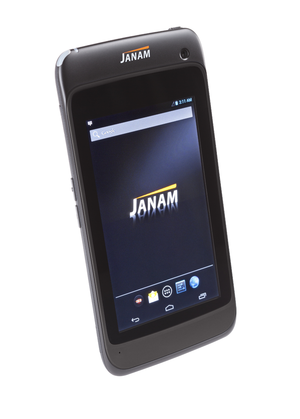
Janam Technologies LLC, a provider of rugged mobile computers that scan barcodes and communicate wirelessly, has launched XT1, a powerful rugged tablet for the mobile workforce. The XT1 rugged mini-tablet is Janam’s first device to support the Android operating system, and is built to meet the diverse needs and demanding requirements of enterprise and government customers.
The XT1 combines best-in-class technologies with a sleek and rugged form factor, providing mobile workers with the information they need to make better informed decisions, increase customer satisfaction, and improve operational efficiencies, the company said. Equipped with integrated 2D barcode scanning technology to eliminate the challenges often associated with camera scanners or bulky sled attachments, the XT1 is designed to improve worker productivity in field sales, field service, healthcare, hospitality and retail markets.
“Many enterprise customers require more screen viewability than traditional PDAs or handheld computers offer, yet full-display rugged tablets are large, thick, heavy and unwieldy,” said Harry B. Lerner, CEO of Janam. “Janam resolves this dilemma. The XT1 blends cutting-edge technologies most often found in consumer phones with mission-critical key features that enterprises need such as ruggedness, sealing, barcode scanning and rapid battery recharging, among others. The result is a sleek, lightweight, rugged mini-tablet that delivers superior performance without sacrificing usability.”
In addition to 4G-ready UMTS/HSDPA/HSUPA/GSM wireless wide-area network communication, the XT1 is equipped with 802.11a/b/g/n dual-band WLAN for access to the information mobile workers need to get the job done, inside and outside the four walls. With IP54 sealing and the ability to withstand repeated three-foot drops to concrete, the XT1 delivers the reliability needed to excel in the most demanding environments, Janam said.
XT1 features include:
Android 4.2 operating system
TI OMAP4470 @ 1.5GHz
5.9-inch WVGA TFT capacitive touchscreen
High-performance 2D data capture
Multiple 3-foot/1-meter drops to concrete
IP54 sealing against environmental elements
Embedded RFID and NFC capabilities
Optional3G/4G WWAN technology (UMTS/HSDPA/HSUPA/GSM)
1GB RAM, 16GB ROM
Wi-Fi 802.11a/b/g/n
Bluetooth 4.0 (BLE)
High-sensitivityGPS and Assisted GPS
Motion sensing accelerometer
Front/rear cameras
User-accessible microSD card slot
3.5mm headset jack
MicroUSB connector
3000mAh rechargeable LiIon battery
According to a new research report from the analyst firm Berg Insight, global shipments of personal navigation devices (PNDs) declined from 28 million units in 2012 to 22 million units in 2013. There are signs that the decline is slowing and some emerging markets still experience growth.
However, on the whole, the PND market is set for a continued downturn on a global basis. Berg Insight forecasts that PND shipments will decline to only 10 million units worldwide in 2019.
A number of developments are affecting the PND market. Retailers have reduced shelf space and marketing for PNDs in favor of other consumer electronics products. Competition from other navigation solutions, especially navigation apps, is also intensifying.
Over time, PNDs will also face further competition from in-dash navigation systems as more car brands launch low-cost systems. Moreover, the installed base of PNDs is already high, and replacement cycles are likely to be prolonged since PNDs have matured considerably and many devices are now sold with lifetime map updates, giving users less reason to replace their existing devices as frequently.
The user experience for handset-based navigation apps is now improving through better integration in the car. Some vendors have released NFC-enabled car mounts enabling the owner to configure the handset to turn on the GPS and launch a navigation app when the phone is placed in the mount. A majority of car manufacturers have also started to offer smartphone integration solutions that connect the vehicle’s infotainment system with the user’s smartphone via Bluetooth, Wi-Fi, USB or HDMI. It is then possible to display and control smartphone apps using the touchscreen and controls in the car.
Higher smartphone adoption along with broader availability of low-cost and free navigation apps are important factors for the continued increase in usage of mobile navigation services worldwide. “The number of mobile subscribers worldwide using a turn-by-turn navigation app on their handset at least once per month grew from 150 million in 2012 to 180 million in 2013,” said André Malm, senior analyst, Berg Insight. He adds that in most markets, smartphones from major vendors now come bundled with free navigation apps.
The leading navigation service providers on a global basis include Google, Apple, Telenav, Appello Systems, Nokia and Garmin. Examples of major local players include AutoNavi and Careland in China, SK Planet in South Korea, NAVITIME and ZENRIN in Japan, as well as Navitel and Yandex in Russia.
Despite increasing competition from free navigation apps, many mobile operators are still marketing their own navigation services developed by companies such as Telenav, TeleCommunication Systems and Appello Systems. “App developers and operators are now trying to monetize navigation apps by introducing premium features and advertising,” said Malm. “Developers are also forced to reduce costs as competition increases, for instance by adopting OpenStreetMap data to reduce map licensing fees.”
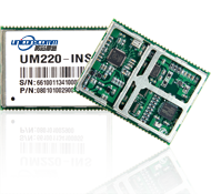
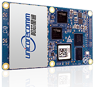
Unicore Communications, Inc., is showcasing two new products at ION GNSS+, being held September 10-12 in Tampa, Florida.
The UM220-INS is a BeiDou/GPS+MEMS dual-system inertial navigation module for in-dash automotive navigation and high-end navigation. Besides dual-system (BeiDou+GPS) GNSS navigation, the UM220-INS features a built in six-axis MEMS and can output a GNSS+MEMS inertial positioning result, making it suitable for applications requiring high accuracy, high reliability, and high continuity positioning.
The second product is the UB280, a BeiDou/GPS dual-system dual-antenna high-precision heading board for precise RTK position and heading. According to Unicore, UB280 is based on Unicore’s mature BeiDou compatible multi-system GNSS system-on-chip (SoC), features low-power design and dual-antenna input, can offer millimeter-level carrier phase observation value and centimeter-level RTK positioning accuracy, and supports multi-path mitigation. Its advanced technology of instant and long-distance RTK is designed for high-precision positioning, navigation, and heading applications in static and dynamic environments.
Features of the UM220-INS include:
Built-in six-axis MEMS. UM220-INS has a built-in MEMS with a 3-axis gyroscope and a 3-axis accelerometer. The solution fusing GNSS and inertial MEMS enables car-navigation devices to provide a continuous and stable position under complicated environments such as basement parking and tunnels, regardless of satellite visibility.
High-Sensitivity Design. With Unicore’s Ultra-Sense high-sensitivity design, UM220-INS can provide excellent acquisition and tracking sensitivity under weak signal conditions, maintaining the position continuity and reliability of the receiver.
High-Integrated Design. Different from traditional GPS navigation products, built-in MEMS devices support the odometer / speed pulse, the reversing signal input, and more integrated, simplified overall unit manufacturers’ design.
DGNSS and AGNSS Supprt. UM220-INS has extended support for differential GNSS and assisted GNSS positioning functions, and supports RTCM2.3/3.0.
Backward Compatibility with UM220. The UM220-III N module is backward-compatible with the UM220 in size and interface, which makes upgrades easy.
UB280 BDS/GPS dual-system dual-antenna high -precision heading board. Photo: Unicore
Features of the UB280 incude:
Design standard. This board is totally compatible with mainstream OEM boards in dimensions and electrical standards for the convenience of user’s further development. Apart from this, more hardware interfaces are available.
Rapid RTK Integer Ambiguity Resolution. With super strong RTK algorithms, it ensures more rapid initializing speed and can make a GNSS-RTK solution on multi-constellation, thus ensuring users take the lead in the interoperability era.
Web Interface. The UB280 supports an Ethernet interface, so users can configure the board through Ethernet, managing, upgrading, and restarting the device remotely.
Instant Heading Technology. With an innovative RTK algorithm, Unicore has developed the real-time dynamic heading technology on variable baseline length for a moving base station. High-quality carrier observation and perfect RTK algorithm can provide a 0.2° heading accuracy on a 1-meter baseline.
Graphical Interface. Based on the graphical Control and Display Tool (CDT), the state, SNR and elevating angle of the satellites of all the constellations could be displayed on the screen, which is convenient for application development.
Unicore Communications is located in Booth 118 in the ION GNSS+ exhibit hall.
Broadcom Corporation today announced the industry’s first low-power GNSS and sensor hub combo chip to deliver new always-on location applications for a full range of mobile devices.
The Broadcom BCM4773 minimizes battery drain and adds a new layer of intelligence to location technology on mobile devices by integrating the GNSS chip and sensor hub into a single combo chip. Broadcom’s architecture enables information from Wi-Fi, Bluetooth Low Energy (BLE), GPS and micro electro-mechanical systems (MEMS) to be calculated on a single system-on-chip (SoC) instead of the application processor (AP). This design drives more than 80 percent power savings by offloading from the AP and lowers cost by reducing board area by 34 percent.
“Broadcom today extends its leadership by announcing the industry’s first combo chip that brings GNSS and sensor hub technology together to revolutionize mobile apps in areas such as health, fitness and lifelogging,” said Mohamed Awad, Broadcom director, Wireless Connectivity. “We are proud to make all mobile platforms even smarter by enabling them to dynamically predict and react to consumers’ needs.”
Additionally, Broadcom brings more intelligence to context awareness by integrating GNSS and providing a direct connection to the Wi-Fi combo chip. This allows a mobile device to know where a user is and what the user is doing to further personalize the experience. For example, a BCM4773-based smartphone can use information from Wi-Fi, BLE, GPS and MEMS to recognize when a runner is outdoors versus inside on a treadmill and dynamically manage these technologies to save battery life and optimize the user experience, all without involving the main AP.
Key Features:
Optimized for hardware offload of sensor fusion, on-chip positioning, geofencing and location batching
More than 80 percent power savings compared to standard GNSS receivers
34 percent board area reduction by integrating GNSS receiver and sensor hub
Standalone microcontroller offloads fusing of sensor data from the AP to maximize power savings
Concurrent support for five different satellite systems, including GPS, GLONASS, SBAS, QZSS and BeiDou
Ultra-low power on-chip positioning for background and foreground location using GNSS
On-chip Wi-Fi positioning using a direct connect communication protocol to the Wi-Fi SoC
Batching support for all devices connected to the Location Hub, including Wi-Fi, MEMS and GNSS
Advanced Search Engine Replaces Google Local Search in 122 Countries
deCarta, Inc., an independent LBS platform company, is now providing the local search function for a worldwide, top-five mobile handset manufacturer. deCarta has been hosting and running the search service since August 7 using its advanced geosearch engine — L2 — and has replaced the search service previously provided by Google. The service delivers millions of responses per day to this handset manufacturer’s local search and mapping application to users in 122 countries.
deCarta’s L2 is a high-performance, scalable local search engine with single line input and intuitive user interface. deCarta sources and indexes map and POI (points of interest) content from a wide variety of sources globally but also enables customers to easily index, control and search on their own content. The customer service announced utilizes TomTom map and POI content.
deCarta’s L2 can be used as a pure geocoder for address search, or for POI search, or simultaneously as a combination of the two mixed in a single-line search query — with the additional ability to tune this behavior at runtime. This gives developers maximum flexibility and creativity in producing their applications. deCarta recently expanded country coverage to enable its customers to offer global services.
The L2 Search engine is an integral component of deCarta’s LBS platform which provides specialized geospatial technologies for maps, routing, navigation, geocoding, local search and geo-data integration and processing. deCarta provides its white-label LBS platform to companies that wish to offer their own customized, branded LBS services as opposed to utilizing industry standard services such as Bing or Google.
deCarta has two deployment options for its platform: a hosted LBS Platform Service (PaaS) or, alternatively, customers can self-host either on-premise or in a cloud service such as Amazon’s AWS. Both approaches utilize deCarta’s REST API architecture and can scale to support billions of maps and searches and millions of users per month.
“We are quite happy with the market reaction to L2 since its introduction last year,” said J. Kim Fennell, CEO of deCarta. “We’re seeing large mobile, telematics and automotive customers switch to L2 in competition against other local search engines and geocoders such as Google, Bing, Nokia/Here and Pitney Bowes. Customers appreciate L2’s technology advantages, customization capabilities, flexible content offerings, less restrictive license terms and our superior customer service — all of which creates a more satisfied end customer experience.”
L2 enables deCarta’s customers to offer flexible, advanced local search capabilities that are on par with Google Maps but beyond other search engines. Examples include:
Single line entry of POI or address or both
Fast typeahead, predictive entry – ideal for mobile devices
High tolerance for misspellings and partial entries
Random ordering of address parameters
Search for a POI near a POI such as “ATMs near AMC Theater” or “Parking near SFO”
Search for POI near a specific address, i.e. “Parking near 1234 Main Street”
Furthermore, L2 can be integrated with deCarta’s patented “Search Along A Route” technology. This combined with the ability to index custom content and boost result rankings gives automotive OEMs and service providers the ability to offer more advanced and helpful “driver-centric” connected car services.
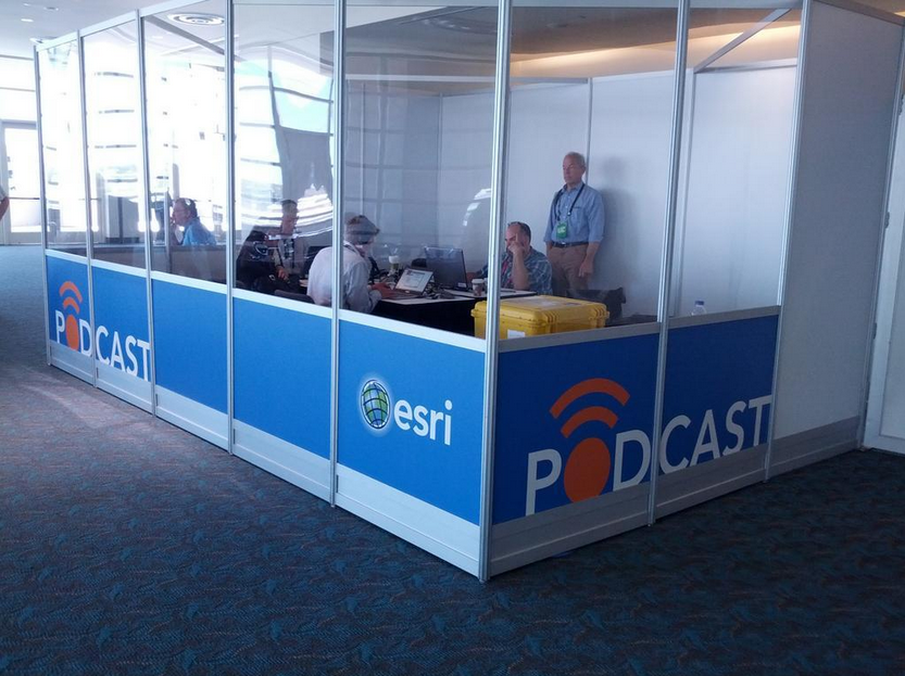
A few weeks ago at the Esri 2014 International User conference in San Diego, California, we conducted our first live event webinar from a Plexiglas booth sitting among many of the 14,000+ attendees buzzing around inside the San Diego Convention Center.
The webinar focused on high-precision GNSS on mobile devices (iOS/Android/Windows), unmanned aerial systems (UAS), and real-time GIS transactions. These are hot topics in the geospatial world, and that was confirmed when I received about 100 pre-webinar questions and more than 100 post-webinar questions.
In my article this month, I’ll do my best to provide answers to the questions asked. If I don’t get to your question, or if you have another, please email me at [email protected].
First of all, if you didn’t attend the webinar and would like to view the recording, you can register here and you’ll be provided a link to view it. It’s a great, interactive discussion. I grabbed Sharad Garg, iOS consultant, from the Esri show floor to talk about the intricacies and complexities of using GNSS receivers on iPads and iPhones.
Without further delay, following are some of the more popular pre- and post-webinar questions I received.
Mobile Devices
First, I’ll start with the questions about mobile devices and high-precision GNSS.
1. Will Android be the dominant mobile tablet platform in the Enterprise?
It’s hard to say. I recently met with a group of enterprise IT professionals and we were discussing this issue. Basically, the group was equally divided into thirds. One third were using Android. one third were using iOS, and one third were using Windows.
Android advantages: Lots of mobile devices available that run Android. Android disadvantages: Open source = non-standard implementations, so app software may not run on every device; security concerns.
iOS advantages: Consistent user interface, consistent software development environment, popularity of iPad and iPhone. iOS disadvantages: Closed ecosystem (very limited number of tablets); doesn’t interface to devices (such as GNSS) that haven’t been through the Apple certification process; security concerns.
Windows advantages: Security; lots of legacy apps and utilities written for Windows. Windows disadvantages: Limited number of tablets being deployed based on Windows.
For enterprise organizations, data security is a huge concern. Since Android is open source and gaining the most market share (at least in the consumer market), it’s got a target on its back for hackers. That’s the biggest concern I hear from corporate IT professionals. How will Android device developers address that, or will they? The consumer market for Android devices is exploding regardless of security. Do they even care about the enterprise market? Apparently Apple does as it recently signed an agreement with IBM to address the enterprise market, with IBM committing to deploying more than 100 enterprise solutions for iOS.
Site of the webinar broadcast from the Esri UC.
2. Which mobile platform is the most universal/easy to integrate with GNSS receivers?
Out of the box, Windows and Windows Mobile devices are still the easiest to interface to external GNSS receivers for the average consumer. Using Bluetooth, serial or USB, NMEA (or proprietary binary) data flows easily via the device com port or virtual com port. If you’re using a Bluetooth interface, there is some inconsistency among mobile devices due to the different versions of Bluetooth management software used on mobile devices, but it’s workable, and worst case you can buy an inexpensive third-party Bluetooth software manager like BlueSoleil.
With the use of an app such as Bluetooth GPS that allows you to select an external GNSS receiver, connecting your Android device to an external Bluetooth GNSS receiver is relatively painless.
Apple products are the toughest to integrate with external GNSS receivers via Bluetooth. Each GNSS receiver has to be specifically designed with an Apple Bluetooth authentication chip and be subjected to the Apple certification process, which can be lengthy and costly. This is the reason why you see very few Bluetooth GNSS receivers available for Apple products. The good news is that once the GNSS receiver is approved, the Bluetooth connection happens automatically when the GNSS receiver is in range of the Apple device. No com port config, no baud rate to worry about, etc.
3. What is available on Android that will make my smartphone a practical and useable tool that can assist in collecting professional data?
First of all, you need to find a high-precision Bluetooth receiver to connect to your Android device. Then, establish the Bluetooth partnership between the Android and GNSS receiver (scan for Bluetooth devices, enter passcode, etc). Once you have that, download the Bluetooth GPS utility I mentioned above and it will allow you to select which GNSS device to use (external vs. internal). Once you’ve selected the external GNSS receiver and connected to it via Bluetooth, every location app on your Android device will use the high-precision GNSS receiver for location.
This applies to an Android tablet or Samsung Galaxy phone. Take a look at this article to see how I ran RTK on a Samsung Galaxy using a Bluetooth RTK receiver.
Today’s challenge is finding “professional” GIS data collection apps that run in the Android environment. There are a few, but the selection is limited. Esri has its Collector for ArcGIS app that runs on Android, but it requires an ArcGIS server backend or ArcGIS Online account. Other data collection apps like Fulcrum and Amigocloud run on Android as cloud-based services.
4. Is there an actual GPS receiver within smartphones, or are they triangulating off of cell towers?
There’s a GNSS receiver in virtually every smartphone manufactured. The GNSS chips are so cheap (a few dollars) compared to the functionality gained that it wouldn’t make sense not to design a GNSS receiver in a smartphone. Now, just because there’s a GNSS chip in each smartphone doesn’t mean it’s the only technology used for location. For example, Apple iOS uses multiple data sources to determine the location at any given time. It will use a combination of cellular triangulation, Wi-Fi IP address, and internal GNSS receiver and external GNSS.
5. Which applications do you see requiring RTK accuracy within the mass-market applications?
A couple of years ago at the GPS World Leadership Dinner at the ION GNSS conference in Nashville, Dr. Todd Humphreys of the University of Texas at Austin predicted that you’ll have RTK (real-time centimeter accuracy) capability on your smartphone by the year 2020. I agree with his prediction, and I think we’ll see inexpensive Bluetooth RTK “pucks” well before 2020, as I’ve written before.
Often, I get the question raised above. Who needs RTK on a mobile phone?
I can’t tell you any more than that in the early 1970s when GPS was first being conceived, not one could tell you what GPS would be used for today. I love the following quote from Steve Jobs: “People don’t know what they want until you show it to them.”
6. Since many devices are complete systems with GNSS inside, do you see the direction of the industry moving towards remote “add-ons” like Bluetooth receivers?
Bluetooth receivers are certainly trending, and it’s primarily driven by the explosion of powerful yet inexpensive tablets and smartphones in the past five years, starting with the iPad/iPhone, and now with Android devices and smartphones in general. People want to use their consumer devices in a professional capacity and some need high-precision GNSS receivers, so that’s driving the demand for “add-ons” like Bluetooth GNSS receivers, laser rangefinders, and more.
Unmanned Aerial Systems
Ok, let’s transition to some questions on UAS (such as UAV, drones).
1. Do you see the FAA allowing simple operations for very low altitude UAV-sensors?
It’s difficult to speculate what the FAA will implement, but I have to think, based on its past behavior, that the initial rules will be super-conservative with minimum requirements being that a licensed pilot will be required to operate the UAS in addition to strict equipment requirements.
What’s going to be interesting to observe is what the FAA will do about the hundreds (maybe thousands) of UAS operators who will attempt (or are attempting) to “fly under the radar” and skirt the FAA rules. We’ve seen the FAA attempt (sometimes successfully and sometimes not) to crack down on some UAS operators whom it believes are violating the rules, but there have only been a handful of those cases.
2. When do you think the FAA will release rules for commercial UAV users?
I wouldn’t be surprised if the FAA issued some guidelines in September 2015, but I seriously doubt they will publish the full set of rules by then.
By the way, I attended an interesting UAS presentation at the AEC Summit prior to the Esri UC. You can see my write-up of it here.
That’s it for now. I’ve got many more questions from the audience that I’ll address in upcoming newsletters. Stay tuned and feel free to email me directly at [email protected].
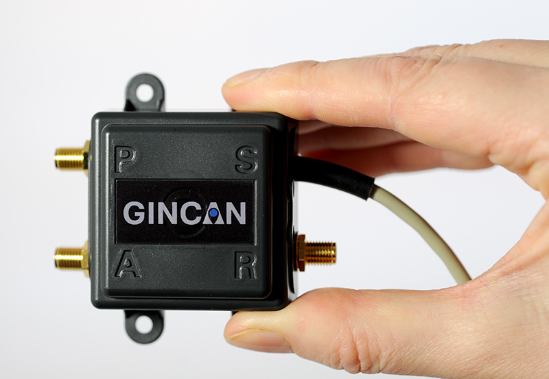
Chemring Technology Solutions has developed miniaturized GPS anti-jamming technology it has dubbed GINCAN. GINCAN is designed to combat illegal GPS jammers and is based on the adaptive antenna concept used by military systems. GINCAN has a chip footprint of six millimeters squared.
GINCAN’s reduced size and weight will significantly cut power usage and cost, the company said, making it ideal for combatting the widespread problem of low-powered GPS jamming. GINCAN can be integrated into a range of applications, including in-vehicle satellite navigation systems and cellular technology, and can be used for the protection of the critical infrastructures which rely on GPS to provide positioning and timing.
GPS jammers have already been developed to interfere with the European Union’s Galileo system, which will provide European satellite navigation independently from the Russian, USA and Chinese systems by 2019. Chemring Technology Solutions, based in Romsey, England, has anticipated this problem and its GPS anti-jamming technology will also support systems using Galileo.
Once the preserve of the military, there is now an increasing demand for GPS protection in the civilian market as illegal GPS jamming equipment becomes widely available on the Internet. The £1.5 million government-funded Sentinel project, designed to measure GPS jamming on UK roads, recorded more than 60 individual jamming incidents across six months at a single location. Such attacks could seriously impact industries, including maritime, aerospace, the emergency services and even stock market trading.
“Many years of developing GPS protection technology for the military has enabled our research and development team to miniaturize anti-jamming technology,” said Martin Ward, product manager, Chemring Technology Solutions. “GINCAN can now be easily integrated in to a range of applications to provide effective protection against jamming devices.
“As we become increasingly reliant on GPS technology, and low-cost jammers are proliferating, so a potential time bomb is being created. Chemring Technology Solutions is now able to offer the answer to this problem with jammer protection at a reduced size, weight, power and cost footprint.”
GINCAN is an export controlled product and subject to UK export restrictions.
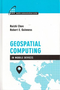
A new text and reference book, Geospatial Computing in Mobile Devices, has been published by Artech House. Recent developments in smartphones enable them to meet many of the demanding requirements for geospatial computing, in terms of computation power, data storage capacity, and memory space. This book, written by Ruizhi Chen and Robert E. Guinness, addresses and instructs in geospatial data acquisition, processing, visualization, context detection, and context intelligence.
Chapters of the 209-page book include:
Fundamentals of Mobile Positioning
GNSS, Wireless, and Hybrid Positioning in Mobile Devices (three separate chapters)
Mobile GIS and LBSs (two separate chapters)
Context Awareness and Reasoning (two chapters), and
Available for iPhone, iPad and Android, VIIRS View provides mobile device users a look into the type of data meteorologists and climatologists use every day to track the weather and monitor Earth’s environment.
Based on data generated by the Visible Infrared Imaging Radiometer Suite aboard Suomi NPP, VIIRS View combines visible light imagery, low-light nighttime imagery and ocean chlorophyll concentration onto a full Earth globe, rotatable and zoomable on any location on the planet.
A desktop version of the VIIRS View app, launched in February, has been downloaded more than 90,000 times.
An original large format VIIRS View interactive tabletop display is being shown at Raytheon Booth #203 at the the 30th Space Symposium, being held this week in Colorado Springs, Colorado. GPS World Defense Editor Don Jewell is providing coverage from the symposium.
The app can be downloaded by searching VIIRS View at the Google Play and Android stores, or by clicking here: