New web tool exports ready-to-deploy XML files, enabling fast and centralized pre-configuration of Eos Tools Pro GNSS settings.
Eos Positioning Systems has released the Eos MDM Configurator, a web‑based tool that allows organizations to quickly create and deploy pre-configured Eos Tools Prosettings across large numbers of mobile devices via their third-party mobile device management (MDM) systems.
Until now, administrators who wanted to deploy Eos Tools Pro through their MDM needed to write an XML configuration file manually — a process that was time consuming and potentially error-prone. The Eos MDM Configurator eliminates manual coding entirely. The tool guides users step‑by‑step through five GNSS categories, supplies a preview of the XML code, and allows the user to export their XML file, compatible with any third‑party MDM solution.
With the Eos MDM Configurator, organizations can centralize control of Eos Tools Pro settings, standardize GNSS data quality, and save time by eliminating manual app configurations.
The five categories that can be pre-configured using the tool include differential corrections, altitude and geoid model, datum shifts, alarms and miscellaneous.
The Eos MDM Configurator is available at no cost to Eos GNSS receiver users. All that’s required to build a configuration is a desktop browser with Internet access. Deploying the resulting XML file requires a third‑party MDM solution, an Eos GNSS receiver (any model), Eos Tools Pro, and at least one mobile device running iOS or Android.
GNSS corrections company Rx Networks is collaborating with Zephr.xyz, whose software-based positioning SDK enables sub-meter accuracy on Android devices without requiring specialized hardware.
Through this collaboration, Zephr.xyz has integrated Rx Networks’ TruePoint correction services, extending high-precision GNSS capability worldwide with the reliability, availability and continuity required for commercial-scale deployment.
Operating on a global scale, Rx Networks is a provider of GNSS positioning services for tier-1 OEMs, telecom operators, and enterprise customers. Its services are engineered to ensure a five-nines (99.999%) service level agreement for availability, supporting mission-critical and safety-critical applications where continuity, resilience and predictable performance are essential.
Unlike free, experimental or regionally constrained solutions, Rx Networks’ infrastructure is designed for global availability and long-term operational reliability, making it suitable for large-scale commercial deployments.
TruePoint is Rx Networks’ comprehensive high-precision positioning portfolio, designed to support a broad spectrum of customer requirements. Rather than a one-size-fits-all product, TruePoint has solutions that span
global, regional and localized GNSS correction services
accuracy tiers from decimeter-level to centimeter-level performance
multiple deployment models and price-performance options.
TruePoint is designed to evolve alongside customer needs, supporting everything from early-stage experimentation to large-scale production deployments. While Zephr.xyz leverages TruePoint | FOCUS, the collaboration is not limited to a single TruePoint variant, preserving flexibility as applications mature.
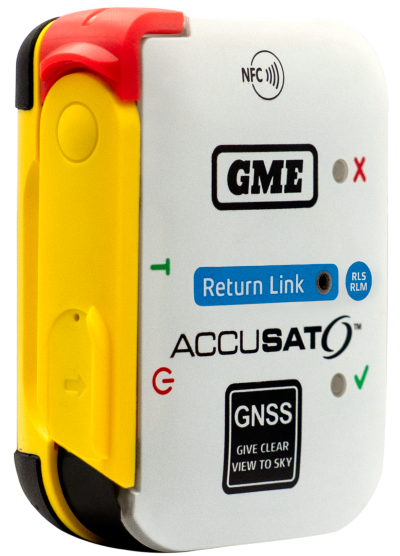
Austtralian company GME is offering its first emergency beacon with Return Link Service (RLS). RLS confirms the distress signal has reached a rescue coordination centre (RCC), providing critical reassurance in an emergency.
The MT620GR personal locator beacon (PLB), with integrated RLS and a mobile app, is a compact safety companion for outdoor and marine adventure enthusiasts.
Enhanced with GNSS for precise global positioning and a 121.5 MHz homing signal, it ensures efficient SAR operations. It is approved for worldwide Cospas-Sarsat operation.
The companion mobile app monitors the beacon’s operational status. With a seven-year battery life and a six-year warranty, it offers dependable performance and peace of mind, according to GME.
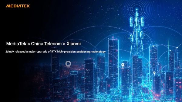
MediaTek, China Telecom and Xiaomi have announced an upgrade to its real-time kinematic (RTK) high-precision positioning technology. The joint development integrates 5G connectivity, advanced chip design and Xiaomi’s smart technology.
RTK technology is usually found in professional surveying tools, but will now be available for location and positioning in smartphones, cars and city networks, according to the companies.
The newly upgraded RTK system enables outdoor positioning with sub-meter accuracy and fast response times. Leveraging 5G network infrastructure, smart data transmission, and close chipset-mobile software coordination, the system could be widely implemented on smart city infrastructure, autonomous driving, and smart transportation.
This partnership is part of Xiaomi’s growth beyond smartphones into urban development and smart mobility technologies under the Xiaomi HyperConnect banner.
The improved collaboration between MediaTek’s cutting-edge chipsets, China Telecom’s network, and Xiaomi’s hardware-software ecosystem enables an optimized RTK performance model that can potentially redefine how smart devices interact in real-world environments.
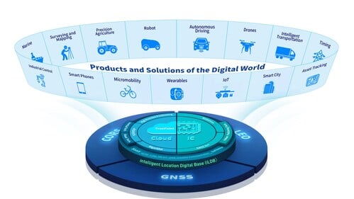
BDStar Navigation Co. Ltd., a provider of positioning technology solutions, has announced its chip-coud integration strategy and introduced intelligent location digital base (iLDB) in Frankfurt, Germany.
iLDB leverages a distributed chip-cloud architecture to create a unified technology and service system. Guided by the chip-cloud Integration paradigm, it combines focused R&D with cross-technology synthesis. This approach delivers robust positioning solutions and powers the integration of physical and virtual environments.
By establishing the iLDB, BDStar has created a closed-loop ecosystem for its positioning products and services, encompassing algorithms, chips/modules, antennas and data services within a unified framework. The company’s solutions deliver on-demand positioning that is all-weather, all-scenario, secure, reliable and intelligently adaptive, serving a wide range of sectors, including intelligent driving, outdoor robotics (such as robotic lawn mowers), unmanned aerial vehicles, and smart wearables across industrial, automotive and consumer markets.
Positioning for Europe. Aligned with the iLDB strategy, BDStar also introduced its new high-precision positioning data service for the European market. Built on network real-time kinematic (NRTK) technology, the service offers broad coverage across Europe and provides customers throughout the region with centimeter-level, real-time positioning accuracy within seconds.
Founded in 2000, BDStar ranks among the world’s top ten suppliers of GNSS core components. In 2025, the company’s global GNSS chip/module shipments are expected to exceed 100 million units. Many leading international brands are already integrating BDStar’s GNSS chips, antennas, and data services into next-generation products designed to address changing market demands.
David Zhou, vice president of BDStar, said the company’s chip-cloud integration strategy delivers multiple benefits through one-stop design, supply and support, enabling reduced cost, enhanced efficiency, assured security, single accountability, and rapid, effective troubleshooting.
Ruxin Zhou, founder and chairman of BDStar, emphasized the company’s global vision. “With our chip-cloud integrated model, BDStar will strengthen worldwide partnerships and continue building a world-class, globally covered iLDB,” he said. “We are committed to creating long-term value for our customers and driving progress in the intelligent era.”
Demand for GNSS chipsets is rising globally, driven by growth in key verticals such as automotive and transportation, consumer electronics, and asset tracking applications. According to global technology intelligence firm ABI Research, global GNSS chipset shipments are projected to grow to 2.4 billion by 2029.
China is expected to lead this growth with the highest Compound Annual Growth Rate (CAGR) of 7.2% between 2024 and 2029, followed closely by Western Europe at 6.7% and the rest of the Asia-Pacific region at 5.6%. In contrast, the Middle East and Africa is anticipated to see slower growth, with a CAGR of 2.7%.
“We are seeing a growing demand for consumer electronics, especially in countries like India, Indonesia, Vietnam and Thailand,” explains Rachel Kong, research analyst at ABI Research. “This is fueled by the rapidly growing middle-class populations and smartphone penetration rates, which are boosting the adoption of GNSS-enabled smartphones, wearables and tablets. In particular, the Sport & Wearables category – which includes devices such as smartwatches, smart glasses, fitness and wellness trackers, and wearable cameras – is forecast to see the highest CAGR of 13.2% between 2024 and 2029.”
Increased E6 band support
Another key technology experiencing rapid growth is GNSS chipsets supporting the E6 band, an emerging GNSS frequency designed for high-precision applications. These chipsets are expected to achieve a strong CAGR of 36.7% between 2024 and 2029, largely driven by high-precision applications such as autonomous driving, aerospace, critical infrastructure monitoring, land surveying, and new location-based services.
With increasing global interoperability and integration of multiple GNSS solutions, worldwide demand for seamless, high-precision navigation continues to rise.
“Manufacturers are more willing to adopt multi-constellation chipsets to support a broader range of applications and geographies,” said Kong.
In addition, vendors such as Quectel, Unicore, Trimble and ComNav Technology are increasingly launching and developing products that support the E6 band. Recent updates, including Trimble’s firmware enabling Galileo High Accuracy Service (HAS) on its devices, and Unicore introducing the UM981 high-precision positioning model, demonstrate the growing traction of this frequency band. Multi-frequency bands are also gaining significance by offering enhanced positioning accuracy, improved signal reliability, and better resistance to interference.
“These bands are already widely used in sectors such as aviation, maritime and automotive, and their adoption will continue to grow as new use applications emerge and evolve over time,” Kong said.
The companies on June 29 signed a precise-positioning business partnership agreement that KT hopes will enable precision location services for autonomous vehicles, drones and urban air mobility.
Swift Navigation’s precise-positioning platform improves location accuracy from several meters to centimeters, enabling safer driving, improved efficiency for last-mile delivery and commercial transport operations, and enhanced accuracy for mobile devices.
Rx Networks has added a new extended ephemeris service called StarCourse.
According to the company, real-time ephemeris services provide GNSS chipsets in connected mobile devices a headstart in determining position accurately and quickly. For devices with limited connectivity, typical extended ephemeris solutions have provided a headstart with 7-14 days of ephemeris data.
With the evolution of the internet of things (IoT), low power consumption and a limiting of connection time are essential for extending the usable life of a device. This creates a challenge for IoT vendors seeking an extended ephemeris offering that can minimize onboard resource usage without compromising accuracy.
The new StarCourse service provides a 50% reduction in RAM requirements, 90% reduction in CPU cycles, and ephemeris accuracy exceeding that of previous market offerings. This empowers Rx Networks customers to extend the usable life of their products while delivering an excellent positioning experience, the company said. Full data customization is offered to StarCourse subscribers, allowing them to create optimal solutions for their needs.
StarCourse enables autonomous positioning on a wide array of connected GNSS IoT devices, including asset tracking, wearables, in-dash navigation and mobile devices. For situations where accuracy is paramount, StarCourse Premium provides ultra-precise predicted ephemeris for the first 24 hours.
“GNSS assistance services are essential to solving the spatial intelligence requirements of the booming IoT world,” said Chris Perriam, product owner at Rx Networks. “StarCourse endeavours to quickly enlighten all connected devices with location.”
Rx Networks provides location information to strengthen the connection between people, devices and businesses by improving the GNSS experience and creating enhanced opportunities for next-generation products and services.
Rx Networks TruePoint.io global precise point positioning (PPP) correction service now provides quad-constellation support.
More mobile devices are integrating multi-constellation GNSS chipsets for better positioning. With quad-constellation expanded multi-constellation support, Rx Networks TruePoint.io global precise point positioning (PPP) correction service unlocks that accuracy, providing global PPP corrections for every major GNSS constellation those chips can track.
TruePoint.io global PPP originally delivered GPS and GLONASS corrections. Now, it also provides corrections for Galileo and BeiDou. Mass-market multi-constellation GNSS chipsets can now augment all their satellite measurements with accuracy and fully leverage their positioning capabilities with quad-constellation support.
Consumer devices now have the potential to achieve 50-cm position accuracy when using Rx Networks services for any of the four GNSS constellations. Other internet of things (IoT) and infrastructure applications that do not require real-time positioning can realize 10-cm accuracy in a variety of environments.
Multi-constellation correction capability ushers in new possibilities and use cases for the connected receiver, according to Rx Networks.
TruePoint.io remains ubiquitous and as flexible as possible to GNSS chipsets using industry standard formats, and is also receptive to custom integration services for unique usage scenarios. By offering PPP and other high accuracy services in a variety of data standards, TruePoint.io empowers telecom providers with a straightforward approach to integrating high- accuracy services that provide more value to their client devices, and propels the development of exciting new use cases.
“With this new expansion of TruePoint.io, applications already serviced by Rx Networks can accelerate their market growth objectives with better accuracy and precision using constellations ideal for target regions,” said Vincent Chen, product manager of Truepoint.io. “Being able to deliver global PPP corrections for GPS, GLONASS, Galileo and BeiDou also sets the stage for the addition of more constellations like QZSS. Stay tuned.”
Geospatial data is key to logistics, including for the huge increase in e-commerce we are experiencing following the 2020 COVID-19 shutdown.
The best customer service is if the customer doesn’t need to call you, doesn’t need to talk to you. It just works. — Jeff Bezos
This past year has been a boon for the e-commerce industry. It increased from 4% of retail sales a decade ago and pushed past 20% in 2020, reaching nearly $800 billion — a 32% jump in 10 years.
Online businesses climbed to all-time highs. A few examples stand out. Amazon’s stock increased in value 83% over the course of last year. That type of growth happens with startups and small-cap companies but is usually unheard of with large blue-chip stocks.
Along with Amazon’s growth last year, FedEx had $69 billion in annual sales. DoorDash, an e-commerce food delivery company, has a market valuation of $45 billion, making it larger than Domino’s Pizza, Texas Roadhouse and Yum! Brands combined; and Yum! Brands owns KFC, Pizza Hut and Taco Bell.
The e-commerce global trend in online sales is expected to reach $4.9 trillion in four years based on only 2.14 billion online shoppers. That is less than one-third of the world’s population. There is a lot more room to grow. This past year moved the trend several years forward.
Where are all those goods stored?
Photo: Navy Petty Officer 2nd Class Jasen Moreno-Garcia/U.S. Navy
Each consumer requires an average logistics space of 35 square feet. In the United States alone, there are more than nine billion square feet of warehouse space, and when online sales increase another 10% it will require 3 to 4 billion square feet more of space to keep up with demand.
The increase in freight driven by this trend is captured in the chart below published by the Federal Reserve, with data provided by the U.S. Department of Transportation. The blue line is increasing freight transportation services, while the red line indicates on-hand inventories.
As transportation increases and becomes more reliable — a reflection of the overall health of the logistics supply chain — the amount of on-hand inventory decreases, allowing sellers to free up space and save money, or offer greater variety knowing that stocks can readily be backfilled.
However, when inventories get too low, the system is subject to severe supply shocks, making prices more sensitive to the law of supply and demand. The grey-shaded areas on the chart are economic downturns officially recognized as recessions.
If delivery took six-to-eight weeks these days, it would signal a crisis somewhere in the world.
21st-century logistics
Goods from global corporations now arrive at each customer’s doorstep. This is 21st-century logistics. Home delivery in two days or less is the expectation. The compression of time in this industry is astounding when compared to “the way things used to be.” The way things are compared to the way things used to be reminds me of hearing my grandparents talk about life before automobiles.
Back in my day, ordering from a catalog required calling the company and speaking to a representative. The call had to be made from a corded landline, and long-distance charges might apply. If ordering a gift for someone in the household, it was difficult to be clandestine with everyone nearby. The other option was to mail in an order form. Either way, delivery took a minimum of six to eight weeks, and sometimes more. If delivery took that long these days, it would signal a crisis somewhere in the world.
Knowing where to pre-position supplies ahead of anticipated demand is a geospatial problem. Most think of this in terms of sales to customers and deliveries ahead of seasonal demands, but many countries in the world are facing this dilemma right now figuring out the best way to distribute COVID-19 vaccines. That challenge is taking place in your own community and has been a long-standing public health challenge.
Beginning in the mid-2000s, geospatial information systems (GIS) were brought in to help control outbreaks of the deadly Ebola virus. In 2014, I took a Penn State geospatial intelligence course. The final exam addressed the geospatial challenges of fighting an epidemic. Theoretically, it was difficult to get the required goods to the right place at the right time. But now, it’s not an exercise, and getting it right is not an option.
If you have received the COVID-19 vaccine, you can appreciate the pharmaceutical industry for developing vaccines in record time. However, getting the vaccines to everyone is a logistics challenge, and GIS is the unsung hero. Logistics is the life blood of empires — it is the game of kings and generals. With it, wars are won and commonwealths prosper; without it, empires crumble to dust.
How Geospatial Data Guides the Goods
Back to the traditional understanding of supply chains from seller to buyer. The needs of the buyer are simple: faster, better, cheaper. For the seller, it is much more complex, and considerations deal heavily with location.
Where is the best place to have a distribution center?
Is it more important to be close to a multi-modal transfer station, or to population centers, or are land prices more important?
What about access to highways?
What are the trade-offs in delivery times being further away from the population?
Is the trade-off worth it for the cost of land and lower taxes?
Geospatial data can answer all of these questions, even going so far as to run “what-if” scenarios.
At the local level, transportation logistics schedules the most efficient routing to deliver more packages along the shortest path. This saves time and fuel, as shown in the image below using Maptitude software. Radiuses can also be calculated based on drive times instead of distances.
Caliper truck routing software can be used for planning deliveries that account for vehicle capacities, time windows, multiple depots and more. (Image: Caliper)
Navigation routing applications are dynamic, and pick-ups are automatically routed to drivers while out on delivery runs. Dynamic routing avoids delays such as accidents and road closures.
This same type of technology is used for emergency services to respond to a call. Ambulances, police and fire trucks all use dynamic routing to get to distress calls as soon as possible.
Global transportation logistics also need to account for international laws and regulations as cargo passes through each country. These regulations can be onerous, but the logistics industry has worked out the legalities to ensure a seamless, uninterrupted flow from ship to train to airplane to truck and to final delivery. It is symbolized by the universal 40-foot international shipping container standardized throughout the world.
At each facility, inventories are tracked. Each item passing through receives a time and location stamp. Estimated delivery times are sent via text message to your mobile device or email. When the item is out for delivery, it is possible to watch it on a map as the delivery truck makes its way towards your location. When the item is delivered to your doorstep, a picture of it is sent to your phone with an alert that the package was delivered.
Only a few days earlier, the manufacturer — perhaps on the other side of the world — placed the item in a box and taped it shut; even though you ordered it in your language, the order received by the manufacturer was in their language. The package started its journey to you at the next scheduled pickup, maybe within an hour of you placing the order. Shortly afterward, your order was on a ship or an airplane. As you went about your usual business, the incredibly efficient system of e-commerce sped your package around the world to deliver it to your doorstep.
Logistics has undergone a revolution built upon the most advanced technological innovations: robotics, artificial intelligence, machine learning, mobile devices, cloud computing, electronic payment processing, and a vast geospatial framework.
In fact, it is a continuously operating, seamless, geospatial mesh running on a global scale across all time zones that allows the industry to function. Every aspect of the logistics supply chain relies upon GIS in some way, from land, air and sea navigation from global location-based systems down to inside a warehouse for storage and retrieval of merchandise. Modern-day logistics is a geospatial industry connecting goods and services to consumers, putting the GIS in lo-gis-tics.
Image: U.S. DOT
Can GIS predict the future?
Regarding whether GIS can predict a market correction… I’ll not make a prediction, but the Transportation Services Index (TSI) for March is due to be released today, May 12. If it is down from February, it would mean two months of back-to-back decline. April’s numbers won’t come out until June. However, here is an indicator of where things currently stand. The ports of Long Beach and Los Angeles, CA, the largest shipping ports in the United States is five days behind schedule, which is down from over 10 days in January.
The TSI is a leading indicator of the economy. When 20% of sales are online in a consumer-based economy, the wellbeing of the commonwealth is measured one delivery at a time.
“Trade isn’t about goods. Trade is about information. Goods sit in the warehouse until information moves them.” — C. J. Cherr
William Tewelow
William Tewelow works for the Federal Aviation Administration. He is a graduate of the FAA management fellowship program. He served on special assignment to the U.S. Department of Transportation leading a national strategic geospatial initiative for the White House Open Data Partnership. He is a Geographic Information Systems Professional (GISP) and a speaker for the Maryland STEMnet Scholar program.
He was among the first in the nation to earn a Geospatial Specialist Certification from the U.S. Department of Labor while working at NASA Stennis Space Center. He has degrees in Geographic Information Technology, Intelligence Studies, and is completing a masters degree in Organizational Management.
William is a 23 year veteran for the U.S. Navy serving as a Geospatial Specialist, Imagery Intelligence Specialist, a Naval Aviator, a Meteorologist, and a Tactical Oceanographer. He is married, enjoys writing and traveling.
His favorite quote is, “A man’s mind changed by a new idea can never go back to its original dimension.” — Oliver Wendell Holmes
Agreement focuses on increasing development and capacity for ultra-compact, low-power laser-beam scanners to expand the market
STMicroelectronics and OQmented, a startup focused on MEMS-mirror technology, have agreed to collaborate on the advancement of the technology for augmented reality and 3D-sensing markets. Micro-electro-mechanical systems (MEMS) combine tiny 3D mechanical structures and electrical circuits on a chip to sense and actuate activity.
The joint effort aims to build on the expertise of both companies to advance the technology and products behind the leading MEMS-mirror-based laser-beam scanning solutions in the market.
ST manufactures MEMS sensors, actuators and related components including drivers, controllers and laser-diode drivers. ST is contributing its MEMS design and manufacturing resources to the collaboration.
OQmented plans to further industrialize and mass produce its Bubble MEMS technology, a patented 3D glass-encapsulation method of hermetic vacuum sealing of MEMS micro-mirrors. The glass bubbles eliminate environmental contaminants and minimize light-refraction effects.
Automotive grade. Vacuum sealing is a key element for meeting automotive-grade requirements, while simultaneously reducing power consumption by an order of magnitude and enhancing performance for resonant, bi-axial scanners, where the MEMS mirrors move in both axes at their resonant frequency, creating an ultra-compact and power-efficient scanning solution. The resonant mirrors are suitable for display and 3D sensing applications in mobile devices.
“In teaming with ST, we’ve chosen a solid semiconductor partner that has demonstrated its leading position in design and manufacturing of MEMS products, particularly MEMS mirrors, over the past 20 years,” said Ulrich Hofmann, CEO/CTO and co-founder, OQmented. “Combining ST’s expertise in developing, marketing, and manufacturing key components for laser-beam scanning solutions with OQmented’s knowledge and intellectual property will contribute greatly to our product offering, manufacturing capacity, and marketing channels, while also expanding the market in numerous application areas.”
“Our goal in working with OQmented is to leverage our shared expertise and deep understanding of laser-beam scanning technologies with the mutual vision to continue the adoption and growth of laser-beam scanning in key applications, such as augmented reality and 3D sensing,” said Anton Hofmeister, vice president and general manager, MEMS Microactuator Division, STMicroelectronics.
From the joint effort, ST and OQmented plan to market a wide range of scanning solutions. These would include MEMS mirrors, MEMS drivers and controllers, and complete reference designs of laser-beam scanning engines for a range of applications. The companies also intend to collaborate on a laser-beam scanning roadmap and the development of future technologies and products.
Mobile GIS Services (MGISS) has been awarded a place on the United Kingdom government’s procurement platform G-Cloud.
Designed to ease the procurement of cloud services by the public sector, the G-Cloud 12 framework makes it easier for customers to find, review and contract MGISS’s advanced geospatial software services through an online digital marketplace. Managed by Crown Commercial Services, it is forecast that successful suppliers, such as MGISS, will receive up to £2 billion in business.
In a parallel achievement, MGISS has also been accredited as a supplier of software, hardware and support services to the utility sector by the supplier assurance company Achilles.
A specialist in mapping and geographic information technology, MGISS also is working alongside organizations such as United Utilities and Northumbrian Water Group and it is hoped that successful qualification under the Achilles UVDB pre-qualification system will help MGISS gain further traction within this sector.
MGISS has also attained the Workplace Wellbeing Charter. Recognizing a commitment to improving the lives of its team members, MGISS received accreditation across a number of facets including leadership, health and safety, mental health and absence management.
“Although recognizing completely different aspects of the business these awards are all significant milestones and accomplishments in their own right and the entire team should be proud of the hard work and commitment they have expended to achieve them,” said MGISS Managing Director and Founder Mike Darracott. “The G-Cloud and Achilles accreditation will put MGISS front and center for the leading players within the public and utility sectors and this will help us capitalise on our work to date with organizations such as Surrey County Council and Wales and West Utilities.
“The Workplace Wellbeing Charter not only recognizes our existing commitment to the health and wellbeing of our team it also gives a benchmark to work from and a toolset to work with to continuously improve,” he continued, “and a happier and healthier workforce will, we hope, make the business even better and stronger.”