Rx Networks Inc., a mobile location technology and services company, has announced support for the NavIC Constellation.
The company made the announcement at ION GNSS+, held earlier this month in Miami, Florida.
Rx Networks’ comprehensive GNSS constellation data service provides technology partners — and their associated customers — real-time and predicted assistance for all satellite navigation systems and L1 satellite-based augmentation systems (SBAS) for any region around the globe.
The addition of NavIC builds on Rx Networks’ brand promise (to deliver “location enlightened” products and services) by providing real-time and predicted GNSS assistance data in any individual or combination of formats. This enables developers to optimize device performance for specific use cases and conform to national requirements.
Data is delivered via ephemeris in RINEX and Predictions in SP3, P-GNSS and RT-GNSS, via the Location.io platform, will be added in the first quarter of 2020.
“Our Location. Enlightened. brand promise speaks to our goal of providing the most comprehensive, relevant, accurate and reliable location data available,” said John Carley, vice president of sales and marketing at Rx Networks. “The addition of NavIC in our carrier-grade infrastructure demonstrates our commitment to our brand and to stay on the leading edge of truly global satellite-based positioning and services. The ability to offer NavIC support is extremely significant as it ensures we can support our customers with exactly what is required in any given region of the Globe.”
NavIC, formerly known as IRNSS (Indian Regional Navigation Satellite System), combines GEO and IGSO satellites to provide a regional position, navigation and time (PNT) system including ionospheric corrections.
“Seen & Heard” is a monthly feature of GPS World magazine, traveling the world to capture interesting and unusual news stories involving the GNSS/PNT industry.
Photo: Nuro
Hey, R2, Where’s my pizza?
Domino’s pizza will start using Nuro’s R2 unmanned vehicles for delivery in Houston, Texas, later this year. Once customers have opted in, they can track the R2 vehicle via the Domino’s app and will be provided with a unique PIN code to unlock a compartment to get their pizza. Nuro is already at work in Houston delivering goods from dinner to dry cleaning.
Screenshot: BBC
Drone Attack
A BBC documentary has sent the drone industry into a tizzy. “Britain’s Next Air Disaster? Drones” begins with the December 2018 Gatwick Airport incident when two drones entering airport airspace led to a disruption of operations for three days. Dronemakers dislike the documentary’s thrust that drones are a threat to public safety and a tool for terrorists, while barely mentioning their positive contributions in fields such as search and rescue, plant inspections and agriculture.
Photo: Rawpixel.com/Shutterstock.com
NavIC Rising
The Indian Space Research Organisation is in talks with chipmakers Qualcomm and Broadcom to substitute GPS in Indian mobile phones with its own satellite system (NavIC). The Times of India noted that cellphones hold the biggest commercial potential for NavIC, with more than 650 million mobile users in India. ISRO and the Indian Air Force are also working to equip fighter jets with the navigation system, and commercial vehicles registered after April 1 are mandated to have NavIC trackers.
Photo: Monitum Pty Ltd.
Infrastructure sensors are Mthing
Internet of things (IoT) project Mthing is researching GNSS monitoring sensors to record near-real-time measurements of infrastructure construction. The 18-month project in Brisbane, Australia, aims to develop GNSS IoT sensors that will provide cost-efficient, constant and high-precision monitoring that will connect to cloud services and provide instant alerts. Mthing aims to produce low-cost sensors with broad market potential. The research team includes Queensland University of Technology, survey company Monitum, and the Innovative Manufacturing Cooperative Research Centre.
The NavIC Indian constellation is now supported in NovAtel’s latest firmware release for its OEM7 series of GNSS receivers.
The 7.05.04 firmware release for OEM7 provides the following benefits:
Users can achieve a single point position accuracy of 2.5 m (rms) using NavIC L5 signals (from the Indian Regional Navigation Satellite System) with GPS L1 on the newly available JSN model.
Access to the L5 frequencies on the OEM7600 and OEM7720 provides triple-frequency capabilities to unlock the potential of GPS L5, Galileo E5a and AltBOC, Beidou B2a and NavIC L5.
A full listing of all changes in this release are included in the “What’s New” document included in the firmware download package. Visit this page to download the latest firmware for a specific platform. Visit NovAtel’s documentation portal for the OEM7 reference manual.
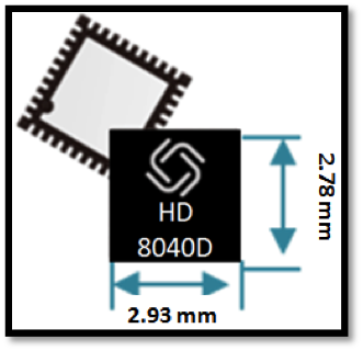
Allystar Technology Co. Ltd. has launched a multi-band, multi-GNSS system on chip, the HD8040 series, to help portable devices save size and weight. The HD8040 offered in wafer-level chip-scale packaging (WLCSP).
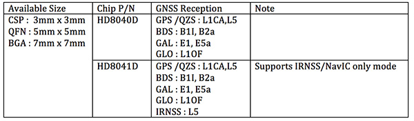
The HD8040 series of chipsets fully supports all civil signals on the L5 band, said Shi Xian Yang, Allystar high-precision product manager at Allystar. Besides GPS, other constellations with L1/L5 signals include Galileo, BeiDou, the Indian NavIC system and Japanese QZSS.
Besides L1 band, HD8040D supports L5/B2a/E5a signals, which are expected to have lower noise and be better in multipath mitigation mainly due to the higher chipping rate of L5 signals relative to L1 C/A code.
HD8041D supports IRNSS (NavIC), which makes it suitable for navigation in urban areas in India and the Middle East, where seven NavIC satellites have a higher elevation than both GPS and Galileo satellites. This means IRNSS (NavIC) would provide greater accuracy, precision and available measurements.
With the features of small size (3 x 3 millimeters) and low power consumption, the HD8040 series is suitable for smartphones, tablets and other portable devices.
The architecture integrates floating-point arithmetic units based on ARM CortexM4, 160 KB RAM, 32 KB backup RAM with VBAT, and 384 KB embedded Flash memory. Besides basic peripheral interfaces UART, I2C, SPI and GPIO, it supports the CAN interface for automotive applications, too.
Customer samples of the HD8040D and HD8041D are available now.
The ground station will be built in Bengaluru, a city that is already home to the ISRO Telemetry, Tracking and Command Network (Istrac). Istrac will host the Russian ground station as well.
A memorandum of understanding was signed between the two nations in October 2016. In return, Roscosmos will host ground-measurement gathering stations in Russia for India’s NavIC, which will boost the operations of the IRNSS satellites.
Telit has introduced a new positioning module aimed at India. The SL869T3-I combines GPS with India’s NavIC (IRNSS) navigation system and the country’s satellite-based augmentation system (SBAS), known as GAGAN.
The SL869T3-I module enables the creation of high-performance position reporting and navigation solutions. It complies with Automotive Industry Standard 140 (AIS-140) — an Indian government mandate that requires the use of NavIC for vehicle location tracking devices in all public transportation vehicles, effective April 2019.
The SL869T3-I is a 16 x 12.2-millimeter module with an LLC package. It is provided with a single RF input for L1 and L5 bands. It also contains Flash memory, a low noise amplifier (LNA) and SAW filters. The RF front end is specifically designed to comply with sensitivity specifications contained in AIS-140 standard.
“The new SL869T3-I is among the first IoT GNSS positioning receiver modules to deliver IRNSS/NavIC L5 coverage compliant with the Indian government’s AIS-140 regulation,” said Manish Watwani, EVP global product management, Telit. “This new addition to the Telit family of products results from more than 20 years’ experience in GNSS applications.”
For more information, visit booth C3.227 at Electronica, Nov. 13-16 in Munich, Germany.
A new GPS + IRNSS module is being developed by Indian firm Ramakrishna Electro Component (REC) in partnership with STMicroelectronics and Shanghai Mobiletek, according to press reports.
The module will rely heavily on the Indian navigation satellite constellation IRNSS (also known as NaVIC), REC Managing Director Shivang Luthra told reporters at an event in New Delhi.
“There have been dependency of imported GPS module which use the U.S., European or Russian satellites,” Luthra said. “We have developed a GPS module, Utraq, that will mainly use the Indian satellites for GPS navigation.”
The module will be produced at a Shanghai Mobiletek factory in China, and the chips will be made by STMicroelectronics. REC owns the Utraq module and will roll it out in October for use in automotive end products. REC says the low cost of the chip compared to imports will make trackers more affordable in India.
The Indian government has mandated use of vehicle location tracking devices and one or more emergency buttons in public transportation vehicles; the mandate took effect April 1.
Utraq will be offered in two models: the L110 GNSS is a compact NavIC module, while the L100 GNSS module is a smaller-sized (patch on top) IRNSS module. Both modules can be used for tasks other than tracking, such as ranging, command, control and timing, and fo marine, aerial and terrestrial navigation.
Curtin University researchers found the launch of new Japanese satellites has boosted satellite positioning capabilities in Western Australia (WA), offering huge potential benefits across numerous industries including mining, surveying and navigation.
New research, published in the journal GPS Solutions, found signals from the recently launched Japanese QZSS satellites provide centimeter-level positioning accuracy, and thus significantly enhanced positioning capabilities in WA, thereby improving accuracy, reliability and availability.
Lead researcher Professor Peter Teunissen, of Curtin’s School of Earth and Planetary Sciences, said these results will improve further when the QZSS signals are combined with those from other satellite systems such as the Indian NavIC system.
Teunissen said the analyses done by Curtin’s GNSS Research Centre demonstrated the highly accurate centimeter-level positioning capabilities that can now be achieved.
“Such improved positioning, accuracy and reliability would offer great benefits when applied in fields such as open-pit mining, surveying, hydrography, automated navigation, structural health monitoring, and subsidence and tectonic deformation monitoring used in the geospatial industry,” Teunissen said. “The benefits are not only restricted to positioning, but cover the whole range of satellite signal applications, including atmospheric sensing (ionosphere and troposphere) as used for climate change and space weather studies, and numerical weather prediction.”
Teunissen said WA was in the fortunate and unique geographical position of being located beneath the flight paths of both the Japanese QZSS and the Indian NavIC regional satellite systems.
“Using both satellite systems, QZSS and NavIC, offers huge benefits to users in Australia – and this is an opportunity to work on future developments with such technologies,” Professor Teunissen said.
“The United States of America, for example, can’t use these signals the way we can in Australia, so this places us in a position of great advantage when it comes to the understanding, modelling and analyses of these satellite signals and their many practical applications.
“The tracking and analyses were done using Javad GNSS receivers and Curtin’s theory of integer ambiguity resolution, which enables millimeter-level satellite ranging, and was achieved with the use of only the four currently available QZSS satellites.”
The results bode well for the future, with the Japanese system being further developed from the current four-satellite system into a mature seven-satellite system that is expected to be operational by 2020.
The report, “Australia-First High-Precision Positioning Results with New Japanese QZSS Regional Satellite System,“ is available online.
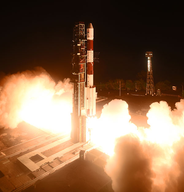
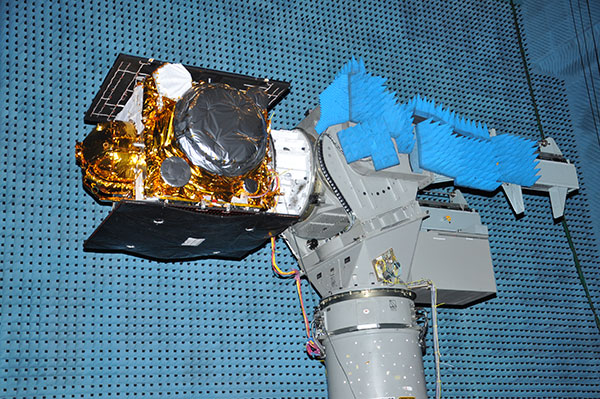
A replacement satellite for NavIC, India’s navigation constellation, was successfully launched April 11 from Satish Dhawan Space Centre SHAR, Sriharikota.
In its 43rd flight, the India Space Research Organization’s (ISRO’s) Polar Satellite Launch Vehicle PSLV-C41 propelled the 1,425-kilogram IRNSS-1I Navigation Satellite into orbit.
PSLV-C41 lifted off at 0404 hrs (4:04 a.m.) IST, as planned, from the spaceport’s First Launch Pad. After a flight lasting about 19 minutes, the vehicle achieved a sub-geosynchronous transfer orbit with a perigee (nearest point to Earth) of 281.5 km and an apogee of 20,730 km inclined at an angle of 19.2 degrees to the equator, following which IRNSS-1I separated from PSLV.
After separation, the solar panels of IRNSS-1I were deployed automatically. ISRO’s Master Control Facility (MCF) at Hassan, Karnataka, took over the control of the satellite. In the coming days, orbit maneuvers will be performed from MCF to position the satellite at 55 degrees East longitude in the planned geosynchronous orbit with an inclination of 29 degrees to the equator.
IRNSS-1I is the latest member of the Navigation with Indian Constellation (NavIC) system. NavIC, also known as Indian Regional Navigation Satellite System (IRNSS), is an independent regional navigation satellite system designed to provide position information in the Indian region and 1500 kilometers around the Indian mainland.
A number of ground facilities responsible for IRNSS satellite ranging and monitoring, generation and transmission of navigation parameters, satellite control and network timing have been established in many locations across the country as part of NavIC.
Another navigation satellite is scheduled to join India’s NavIC constellation this week. IRNSS-1I is on the launchpad, with launch set for Thursday, April 12, at 04:04 (IST), according to the India Space Research Organization (ISRO).
All three rubidium atomic clocks on IRNSS-1A have failed. A replacement satellite, IRNSS-1H, was launched on Aug. 31, 2017, but was not successfully deployed. This satellite, IRNSS-1I, is also a replacement satellite for IRNSS-1A.
Satellite IRNSS-1I will be the eighth satellite to join the NavIC constellation (formerly IRNSS). The satellite will be launched from First Launch Pad (FLP) of SDSC SHAR, Sriharikota, using India’s Polar Satellite Launch Vehicle (PSLV), in its 43rd flight (PSLV-C41) in XL configuration. The XL configuration is being used for the 20th time.
IRNSS-1I undergoes testing at the Compact Antenna Test Facility. (Photo: ISRO)
IRNSS-1I’s predecessors — IRNSS-1A, 1B, 1C, 1D, 1E, 1F and 1G — were launched by PSLV-C22, PSLV-C24, PSLV-C26, PSLV-C27, PSLV-C31, PSLV-C32 and PSLV-C33 in July 2013, April 2014, October 2014, March 2015, January 2016, March 2016 and April 2016 respectively. See the GPS World Almanac for details on the constellation.
Like all other IRNSS satellites, IRNSS-1I also has a lift-off mass of 1425 kilograms. The configuration of IRNSS-1I is similar to IRNSS-1A, 1B, 1C, 1D, 1E, 1F and 1G.
Like its IRNSS predecessors, IRNSS-1I also carries two types of payloads — navigation and ranging. The navigation payload of IRNSS-1I transmits signals for the determination of position, velocity and time. This payload is operating in L5-band and S-band. Rubidium atomic clocks are part of the navigation payload of the satellite.
The ranging payload of IRNSS-1I consists of a C-band transponder, which facilitates accurate determination of the range of the satellite. It also carries Corner Cube Retro Reflectors for LASER Ranging.
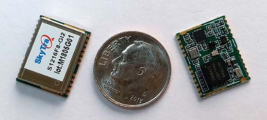
SkyTraq Technology Inc., a fabless GNSS positioning technology company, has introduced the S1216F8-GI2, a NavIC + GPS/GAGAN receiver module for the emerging Indian market.
It integrates L1/L5 RF front-end and baseband processor capable of receiving up to 14 L5 NavIC signals and up to 20 L1 GPS/GAGAN signals simultaneously. With currently usable six NavIC signals and three GAGAN signals, it offers a total of 18-23 usable signals for navigation compared to 9-14 usable signals with conventional GPS receivers, providing improved accuracy in urban canyon environments with signals often blocked by high buildings.
The S1216F8-GI2 has form-factor and pin-out compatability with popular 12 x 16-millimeter GPS receiver modules, so customers using those GPS modules can effortlessly migrate to NavIC/GPS capability by drop-in replacement and changing to an L1/L5 antenna.
For emerging intelligent transport systems (ITS) applications requiring NavIC/GPS capability in India, S1216F8-GI2 enables fast time-to-market for product manufacturers, the company said.
NavIC sub-frame data output is a useful feature of the S1216F8-GI2. It can output NavIC broadcast warning messages related to weather alerts, forecast, and natural disasters such as cyclones, earthquakes and tsunamis.
An S1216F8-GI2 engineering sample, evaluation kit and datasheet is available. Volume delivery to customers begins in late March. The S1216F8-GI2 is manufactured with ISO/TS 16949 automotive certification.
QZS-2 L-band spectra, July 18, 2017, Weilheim, Germany. (Courtesy DLR)
Second QZSS Signal on Air
The successful launch of the Michibiki No. 2 satellite of the Quasi-Zenith Satellite System (QZSS) on June 1 has been followed by broadcast initiation. Researchers at the German Aerospace Center, Deutsches Zentrum für Luft- und Raumfahrt (DLR), have been observing the satellite from their ground station in Weilheim. They will provide a written analysis in the September issue.
The Japan Aerospace Exploration Agency launched first Michibiki satellite of the anticipated four-satellite constellation in September 2010.
Air Force to Recompete GPS III Follow-on
The U.S. Air Force will launch multibillion-dollar competition between current GPS III contractor Lockheed Martin Corp. and former GPS Block I and Block II contractor Boeing Co. for as many as 22 new GPS III satellites. At press time, an industry day in was scheduled for July 20 in El Segundo, California, to solicit company input, according to a new draft Request For Proposals.
In 2015 the Air Force undertook the first phase of a now two-year process to determine whether to put the next block of satellites up for competition. An initial review “has determined that viable, low-risk, high-confidence sources exist to conduct a full and open competition” for a second phase starting in fiscal 2018, according to the draft.
Lockheed Martin is assembling the first 10 satellites of the Block III program. Formal delivery of the first satellite was scheduled earlier this year, delayed by of a series of now-resolved problems with the navigation payload, cracked capacitors and a subcontractor gaffe last year that resulted in the wrong part being tested.
The satellite, which passed all of its qualification testing and verification, has been placed in storage pending the results of an unrelated review of the propulsion systems used to boost military satellites into orbit. The plan remains to launch the first GPS III satellite by spring of 2018.
“Lockheed Martin is working closely with the Air Force on resolving any concerns about the mission readiness of SV01’s Propulsion Subsystem,” Eschenfelder said in February. “We are confident that this review will not delay the Air Force’s planned spring 2018 Initial Launch Capability (ILC).”
NAVIC Clock Failures Resemble Galileo’s
The seven orbiting satellites of the Navigation Indian Constellation (NAVIC, formerly India’s Regional Navigation Satellite System, or IRNSS) have been hit by problems with some of their rubidium atomic clocks, similar to difficulties encountered earlier by Europe’s Galileo program.
NAVIC G-1 launch April 2017.
The Indian Space Research Organization (ISRO) had announced in July 2016 that all three atomic clocks on IRNSS-1A, launched in 2013, had malfunctioned, rendering that satellite ineffective.
Now, reports indicate that four more atomic clocks on the other six satellites launched more recently are not performing as required.
ISRO plans to launch a replacement satellite called IRNSS-1H in July-August to compensate for the loss of IRNSS-1A, although it is yet to announce the failure of more atomic clocks, which has not incapacitated the clock systems on the other six satellites.
The European Space Agency reported in January that anomalies had occurred in three of 36 Rubidium Atomic Frequency Standard (RAFS) clocks in the 18-satellite Galileo system, although none of the satellites were affected. ESA had said, “These failures all seem to have a consistent signature, linked to probable short circuits, and possibly a particular test procedure performed on the ground.”
ISRO has nine satellites indented for IRNSS. While seven satellites make up the Indian regional navigation constellation, the other two were indented as backup in the event of failure. Each satellite has three atomic clocks, one the primary timekeeper and the other two acting as backup.
“Measures are being taken to correct the problems caused by the clocks in the launch of future satellites. The atomic clocks to be used in the other satellites have been modified to prevent malfunction,” a senior official in the programme said.
ISRO chairman Kumar has indicated the number of satellites could go up from the originally envisaged seven to 11 but it is not clear if this is a consequence of the failing clocks. “We are set to launch more navigational satellites. They are in the process of approvals and clearances,” he said recently, and added efforts were on to revive the IRNSS-1A clocks.”
In Europe, the European Space Agency and an industrial partner-supplier have agreed that “some refurbishment is required on the remaining RAFS clocks” to be used in new Galileo satellites.
Look to GSA Service Centre for Galileo Advisories
In July, a wide transfer of responsibilities for the Galileo constellation took place, from the European Space Agency (ESA) to the European Global Navigation Satellite System Agency (GSA) of the European Union. Key among these was a handover of communications responsibilities to manufacturers, users and markets.
All parties can now find updates in the form of Notice Advisory to Galileo Users (NAGUs) at the GSA’s Galileo Service Centre, www.gsc-europa.eu/system-status/user-notifications.
NAGUs are issued as new satellites are launched and when satellites become ready for service provision, or to give advance warning of signal unavailability owing to planned maintenance or testing activities, or to notify users of unplanned outages and then to inform them when satellites become active again.
“Keeping our users in the picture on planned activities that might lead to satellite unavailabilityhas helped them to plan their own test activities and to prepare future products,” said Rafael Lucas Rodriguez, ESA’s Galileo services engineering manager.
A total of 189 NAGUs were issued under ESA oversight in the last four years, as the constellation grew to its current 18 satellites. The user base increased from 86 to 774 registered users on the European GNSS Service Centre website as companies worked to prepare Galileo-ready products. In December 2016, Galileo’s Initial Services began operating.
One regular consumer of Galileo NAGUs, Broadcom, uses them to organize engineering activities and tests as well as input them into its orbit prediction engine for its Long Term Orbits products.