Disclaimer: A previous version of this article contained an error that has since been removed. We strive for accuracy and transparency, and the current version reflects updates correcting this mistake. Please refer to the information below for more current and accurate details on India’s NavIC satellite constellation.
India’s regional satellite navigation system, NavIC (Navigation with Indian Constellation), is facing a severe operational crisis, with only four of its 11 satellites currently operational, according to government data and news reports.
Developed and maintained by the Indian Space Research Organisation (ISRO), NavIC is intended to provide precise positioning, navigation and timing (PNT) services across India and up to 1,500 km beyond its borders. However, this constellation is now on the brink of becoming near-defunct, according to the Indian Defence Research Wing.
Of the four satellites still fully operational, IRNSS-1B has already exceeded its planned 10-year mission life and is at risk of imminent failure. At the same time, IRNSS-1F is also nearing the end of its lifespan with partial equipment failures. IRNSS-1I, launched in 2018, is expected to remain functional until around 2028 but its longevity remains uncertain given the premature failures in the constellation.
The failure of NVS-02 to reach orbit halted progress and highlighted technical challenges that ISRO must address to avoid repeat failures. The Indian government has committed to launching the remaining NVS satellites (NVS-03, NVS-04 and NVS-05) by the end of 2026.
Timely replacement and system upgrades are crucial for maintaining India’s strategic autonomy and meeting the growing demands for accurate, independent navigation services in both civilian and defense applications.
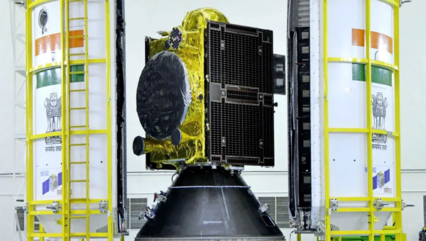
The Indian Space Research Organisation (ISRO) has encountered a significant setback with its recently launched NVS-02 navigation satellite. Launched on Jan. 28, 2025, the satellite is currently stranded in a transfer orbit due to a critical failure in its onboard propulsion system, ISRO stated in a report. The issue occurred when the valves admitting the oxidizer to fire the thrusters for orbit raising failed to open, which prevented the satellite from reaching its intended orbital position.
The NVS-02 satellite, part of India’s Navigation with Indian Constellation (NavIC) program, was launched using a Geosynchronous Satellite Launch Vehicle (GSLV) Mark II rocket from the Satish Dhawan Space Centre. The launch placed the satellite into a geostationary transfer orbit with a perigee of approximately 165 km and an apogee of approximately 37,582 km.
ISRO noted in its statement that other systems on the spacecraft were working well, including a successful deployment of its solar panels.
“The satellite systems are healthy and the satellite is currently in elliptical orbit. Alternate mission strategies for utilizing the satellite for navigation in an elliptical orbit are being worked out,” ISRO stated.
The space agency is now exploring alternative mission strategies to utilize the satellite for navigation in its current elliptical orbit. However, the low perigee of NVS-02 poses a significant risk, as it exposes the spacecraft to high atmospheric drag, potentially leading to an early reentry if the orbit cannot be raised.
NVS-02 is based on ISRO’s I-2K satellite bus, which has been used for other Indian communications and navigation satellites operating in geostationary orbit. The spacecraft had a launch mass of 2,250 kg.
The spacecraft was intended to operate at 111.75 degrees east in GEO, replacing the IRNSS-1E spacecraft there. It is the second of five satellites planned for India’s Navigation with Indian Constellation, or NavIC, program to provide positioning, navigation and timing services in India and the surrounding region. The first, NVS-01, launched in 2023 and operates in GEO.
NVS-01 is the first second-generation satellite of the Indian Navigation Satellite System (IRNSS), also known as Navigation with Indian Constellation (NavIC). It was launched into geostationary orbit on May 20. The satellite is placed at 129.6° eastern longitude and will finally replace IRNSS-1G launched in April 2016.
Whereas the first-generation satellites transmit navigation signals in the L5- and S-band, NVS-01 is the first IRNSS satellite also transmitting in the L1-band. The 1547.42 MHz frequency is also used by other satellite navigation systems, including GPS, Galileo, and BeiDou-3. However, a different modulation is used, namely a Synthesized Binary Offset Carrier (SBOC) signal. The IRNSS L1 SBOC signal has data and pilot components with and without navigation data. Data and pilot signals consist of BOC (1,1) and BOC (6,1) components with sub-frequencies of 1.023 MHz and 6.138 MHz. A quadrature multiplexing is applied for the data and pilot components with a power sharing of 41.82% and 58.18%. The navigation message on the IRNSS L1 signal has a different structure compared to those on the legacy L5- and S-band signals. The new L1 navigation message uses an advanced frame structure and forward error correction inherited from the CNAV-2 message of the GPS/QZSS L1C signal as well as a similar orbit model. Among other things, it provides inter-signal corrections for the L1 data and pilot signals with reference to the S band signal for single-frequency L1 band users.
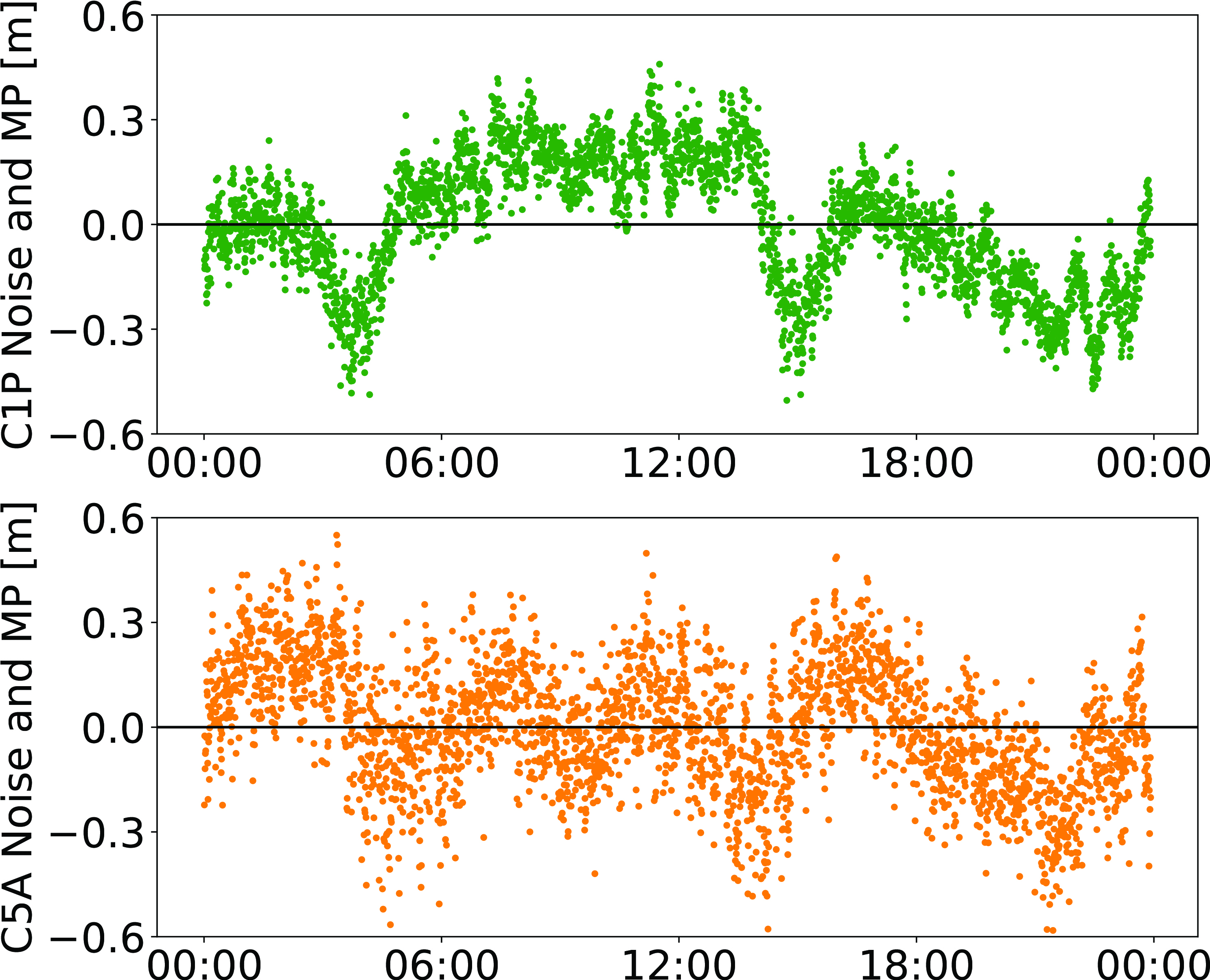
NVS-01 started signal transmission on June 17, 2023, with the pseudo-random noise (PRN) code I10. The satellite’s L1 and L5 signals were tracked by a Septentrio PolaRx5 receiver located in Tokyo, Japan, with a prototype firmware that is capable of tracking the L1 pilot signal. Figure 1 shows the multipath linear combination of NVS-01’s L1 and L5 pilot signals. Whereas the short-term variations are smaller for L1 compared to L5, the overall RMS is 18 cm for both signals.
Figure 1: Noise- and multipath linear combination for NVS-01’s L1 and L5 pilot signals received on 26 June 2023. (Image: All figures provided by the authors)
Whereas IRNSS-1’s rubidium clocks were provided by Spectratime, NVS-01 is the first satellite operating a new type of rubidium atomic frequency standard (RAFS) developed in India. The short-term performance of GNSS satellite clocks can be evaluated with the one-way carrier phase method. The receiver is connected to a highly stable external clock, e.g., a hydrogen maser. Thus, the receiver clock error is negligible. Measurement biases as well as the delays of ionosphere and troposphere on short time scales are removed by fitting a fourth-order polynomial. If no external clock is available, as is the case for the station in Tokyo, the precise clock information can be transferred from another station by a reference satellite jointly tracked by both receivers.
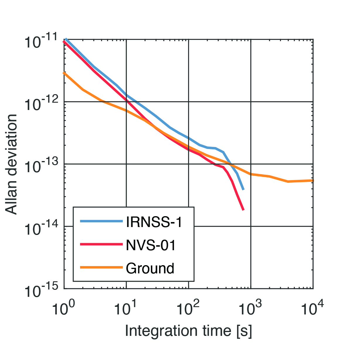
The Allan deviation based on this three-way carrier phase (TWCP) analysis is shown in Figure 2. The hydrogen maser of the IGS station USUD in Usuda, Japan, is used as the reference clock. At short integration times up to 20 s, the Allan deviation computed from the TWCP analysis is dominated by the GNSS measurement noise hiding the true clock performance. Above 20 s, the TWCP demonstrates that the NVS-01’s RAFS stability meets the performance of the ground tests and even exceeds them for longer integration times. At all integration times, the new RAFS outperforms the first generation IRNSS clocks.
Figure 2: IRNSS clock performance obtained from three-way carrier phase analysis as well as ground tests.
Manufacturers
GNSS data used in this article were collected with a Septentrio PolaRx5 receiver.
Peter Steigenberger and Oliver Montenbruck are scientists at the German Space Operations Center of the German Aerospace Center (DLR), where they conduct research in the field of new satellite navigation systems.
Jean‑Marie Sleewaegen is Lead Architect at Septentrio, Belgium, where he has been responsible for GNSS signal processing, system design and technology development since the company’s inception in 1999.
Four T300’s from ComNav Technology have been used as active control GNSS points on the top of Sweden’s tallest building, Karlatornet, during its construction to deliver 3D coordinates to total stations and one was used as a base station. The building is set to be complete this month.
The T300 is a receiver with radio frequency, a baseband chip built in, and a unique quantum-real-time kinematic (RTK) algorithm. It supports full constellation systems including BDS-2, BDS-3, GPS, GLONASS, Galileo, QZSS and NavIC.
The receiver is designed for demanding surveying tasks, features tilt compensation, 4G/Wi-Fi connection, 8-GB internal memory and an easy survey workflow with Android-based Survey Master Software. It is designed to make collecting accurate data easy and fast, whether done by a beginner or experienced professional surveyor, the company said.
The Indian geosynchronous satellite launch vehicle (GSLV) launched on May 29, carrying the first of the Navigation with Indian Constellation (NavIC) second-generation navigation satellites. This brings the NavIC satellite total to nine.
The GSLV, dubbed NVS-01, has a mission life of 12 years and features an indigenous rubidium atomic clock developed by the Indian Space Research Organisation’s Space Applications Centre.
The NVS series satellites will sustain and augment the NavIC with enhanced features, including payloads that operate on L1, L5, and S-bands.
There are eight first-generation NavIC satellites on orbit: IRNSS-1A, IRNSS-1B, IRNSS-1C, IRNSS-1D, IRNSS-1E, IRNSS-1F, IRNSS-1G and IRNSS-1I. NVS-01 will become the ninth if the mission is successful.
GSLV-F12/NVS-01 Mission:
GSLV F12’s 🚀
thunderous roar into the skies…..
Turn up the volume 🔊🔊
to enjoy this tracking 📽️ by our colleagues
at SDSC-SHAR, Sriharikota! pic.twitter.com/XZeE5LWgKW
The Indian government is pushing smartphone makers to sell devices that receive NavIC signals along with GPS.
India originally stated NavIC would be required in smartphones sold starting in January 2023, according to Reuters, but strong reaction from smartphone manufacturers Apple, Xiaomi and Samsung apparently caused the government to push back or remove the deadline.
A deadline of January 2023 would not allow enough time for smartphone makers to integrate NavIC-enabled receivers to their devices. Steps include redesign, securing parts, testing and assembly. Many smartphones sold in India by the companies are economy-level devices priced under US$200.
The three tech giants met with government officials, seeking an extended target date of 2025, Reuters reported.
However, India’s Ministry of Electronics & IT issued a statement via Twitter :
A media report has claimed citing a meeting that mobile cos were asked to make smartphones compatible with NavIC within months. This is to clarify: (1) No timeline has been fixed. (2) The cited meeting was consultative; and (3) the issue is under discussion with all stakeholders.
NavIC (Navigation with Indian Constellation) is the operational name for the Indian Regional Navigation Satellite System (IRNSS) developed by India’s space agency for military and commercial purposes. NavIC consists of eight satellites that cover the Indian mainland and the region extending up to 1,500 km from its boundaries.
“NavIC can help in navigation on land, air, sea and also in disaster management,” Science & Technology Minister Jitendra Singh said in a press release. “NavIC satellites are placed at a higher orbit than the GPS of United States. NavIC satellites are placed in geostationary orbit (GEO) and geosynchronous orbit (GSO) with an altitude of about 36,000 km; GPS satellites are placed in medium earth orbit (MEO) with an altitude of about 20,000 km.”
“NavIC uses dual-frequency bands, which improves accuracy of dual-frequency receivers by enabling them to correct atmospheric errors through simultaneous use of two frequencies,” Singh said. “It also helps in better reliability and availability because the signal from either frequency can serve the positioning requirement equally well.”
Hemisphere GNSS has added to its lineup another Vega heading and positioning OEM board that uses Lyra II and Aquila chipset technology — the Vega 34. The Vega 60 board was previously announced as using the Lyra II and Aquila chipsets.
Hemisphere’s Lyra II and Aquila application-specific integrated circuit (ASIC) designs simultaneously track and process more than 1,100 channels from all GNSS constellations and signals including GPS, GLONASS, Galileo, BeiDou, QZSS, NavIC, SBAS and L-band.
Integrators who use predecessor Hemisphere 34-pin products, such as Crescent Vector H220 and Phantom 34 OEM boards, can easily transition to the improved positioning performance and the superior satellite tracking abilities of the Vega series, the company said.
The Vega 34 board connectors have no circuitry changes and are identical for all Vector users, enabling them to add Atlas H10 and H30 precise point positioning (PPP) into their solutions.
“Vega 34 gives our integrators an easy path forward to enrich their own product offerings,” said Miles Ware, director of marketing at Hemisphere. “For the first time, Crescent Vector integrators can upgrade to multi-frequency without changing pinouts. They can also take advantage of other standard features like more than 1,100 tracking channels, Cygnus interference mitigation technology and spectral analysis.”
NavIC Upgrade. The introduction of the Vega 34 board also brings a new firmware release. Version 6.05 extends several features and improvements and introduces NavIC (IRNSS) tracking and positioning across the entire Vega and Phantom product lines.
Both real-time kinematic and Atlas positioning solutions are enhanced with improved performance in challenging environments. Users of the BeiDou satellite systems and B2b PPP integrators also will see significant advances in their solutions.
Would it be beneficial for GNSS constellations to transmit signals at higher frequencies, such as in the S-band or the C-band, following the example of the Indian NavIC?
Jean-Marie Sleewaegen
“The S- and C-bands refer to frequency bands centered around 2492 MHz and 5020 MHz. The main advantage compared to L-band is the reduced effect of the ionosphere. However, this comes at the expense of higher propagation losses, increased phase jitter due to the lower wavelength, and extra cost in the receiver and antenna when combined with L-band. The added value for existing GNSS systems already transmitting multiple signals in L-band is probably low. However, because they are less congested than L-band, those bands could be attractive to new space-based PNT services.”
— Jean-Marie Sleewaegen, Septentrio
Alison Brown
“The main challenge with adding additional bands to GNSS constellations (other than getting frequency allocations) is that these will not be compatible with any existing GNSS chip sets or fielded antennas. The cost/benefit analysis is unlikely to be attractive for most GNSS chip vendors to develop products with this capability.”
— Alison Brown, NAVSYS Corporation
Ellen Hall
“There are benefits that the higher bands can offer in GNSS, however the constellation and system must be designed to take advantage of them, which makes it very difficult for the legacy systems that were designed around L-band only to tap into any of these benefits. Higher bands have lower ionospheric distortion, which enables better single-frequency accuracy and unlocks some interesting multi-frequency capability, while shorter wavelengths can allow for smaller antennas in user equipment. However, the tropo/atmospheric distortion gets worse as well as the spreading losses. Another consideration for the higher bands is spectrum interference, as the S-band area especially is extremely busy.”
First, there was one. In July 1995, the U.S. Air Force declared the Global Positioning System had met all the requirements for full operational capability (FOC). Soon thereafter, there were two. In December of that same year, Russia’s Globalnaya Navigazionnaya Sputnikovaya Sistema (Global Navigation Satellite System, or GLONASS), also achieved FOC. For a quarter century, that was it.
Then, last year, the number doubled, as both the European Union’s Galileo and China’s BeiDou Navigation Satellite System (BDS, named after the Big Dipper asterism, which is known in Chinese as Beidou) achieved FOC.
The Indian Regional Navigation Satellite System (IRNSS, aka Navigation Indian Constellation, or NavIC, which means “sailor” or “navigator” in Hindi) and Japan’s Quasi-Zenith Satellite System (QZSS, also known as Michibiki) are not global yet, but plan to become so. Currently, NavIC is an autonomous regional satellite navigation system, and NavIC-based trackers are compulsory on commercial vehicles in India. QZSS currently complements GPS to improve coverage in East Asia and Oceania, but Japan plans to have an operational constellation of seven satellites for autonomous capability by 2023. The Korea Positioning System (KPS) plans to join the party by 2035.
Who’s next? Will it be another country or a private company? Given that the state-sponsored systems are free to end users, I don’t see what the business model would be for a private GNSS constellation, unless it were to piggyback on one built mainly for another purpose.
Surveyors who have begun to routinely use three or more constellations are over the moon. One, quoted in this month’s cover story, recalls that “the use of GPS for construction staking was an extremely risky proposition” because its residuals exceeded most construction tolerances. Using multiple GNSS constellations, however, has increased confidence in the accuracy of results to the point that some construction companies are relying on GNSS receivers for staking. Additionally, multi-constellation receivers can now increasingly be used under tree canopies and against structures, whether natural or built.
Whatever their mix of military, political and commercial motivations for building, deploying and operating their own GNSS constellations in addition to the original two, the European Union, China, India, Japan, Korea and whichever entity may follow are greatly improving satellite-based positioning, navigation and timing (PNT) for all users everywhere — by increasing accuracy, shortening the time to first fix, and making GNSS more impervious to jamming and spoofing.
In 1978, the year that the U.S. Department of Defense launched the first NAVSTAR GPS satellite (“NAVSTAR” was later dropped from the system’s name), Neil Young sang “Four Strong Winds” (originally written by Ian Tyson and performed by him with his wife Sylvia as the Canadian folk-duo Ian and Sylvia).
Now, GNSS has “four strong winds,” two lighter ones and several more breezes to follow. As a sailor and a navigator, I welcome them heartily. As this magazine’s editor-in-chief, I don’t mind that, like Jeep, Kleenex, Popsicle and Xerox, GPS probably will stick in popular culture as a generic term for global satellite navigation systems way past its accurate description of what is in the box.
A new draft policy in India seeks to foster global use of its Indian NavIC satellite navigation system. The draft Indian Satellite Navigation Policy 2021 (SATNAV Policy 2021) is part of reforms of the Indian Space Research Organisation (ISRO)/Department of Space (DoS).
“ISRO/DOS shall work towards expanding the coverage from regional to global to ensure availability of [the] NavIC standalone signal in any part of the world without relying on other GNSS and aid in wide utilization of [the] Indian navigation system across the globe,” states the policy document.
DoS will push NavIC for global use to meet demand for positioning, navigation and timing in commercial, strategic and societal applications. It aims to ensure the continuous availability of free-to-air navigation signals for civilian uses, while providing secured navigation signals for strategic uses.
The draft document plans for continuity of NavIC and GAGAN services, while also ensuring Indian satellite navigation and augmentation signals are compatible and interoperable with other GNSS/SBAS signals. The International Telecommunication Union (ITU) regulated frequency allocation to prevent interference among signals from different systems. This interoperability allows users to seamlessly switch from one constellation system to another and results in improved navigation signal, especially in a situation where an area is obscured from one satellite system.
DoS will continue to work with ITU for frequency allocation. It will also take part in the United Nations Committee on Peaceful Uses of Outer Space (UNCOPUOS), International Civil Aviation Organisation (ICAO) and International Maritime Organisation (IMO).
In addition, ISRO will provide technical support for academic institutions in GNSS research and applications.
New modules enable entertainment, advanced connectivity features and next-generation artificial intelligence
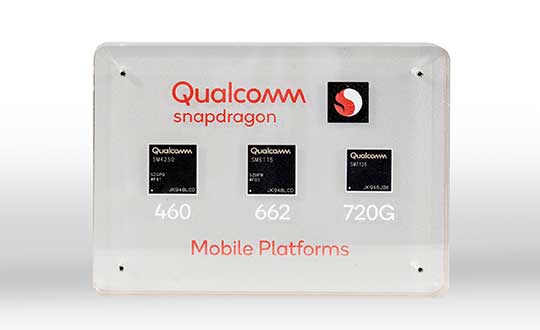
Qualcomm Technologies has launched three new mobile platforms — the Qualcomm Snapdragon 720G, 662 and 460 — to enable enhanced user experiences across connectivity, gaming and entertainment.
The new mobile platforms support dual-frequency (L1 and L5) GNSS to improve location positioning accuracy and robustness. The system-on-chip solutions also support the Indian NavIC (Navigation with Indian Constellation).
Seven constellations. For the first time supported on mobile, the Qualcomm Location Suite now supports up to seven satellite constellations concurrently, including the use of all of NavIC’s operating satellites for more accurate location performance, faster time-to-first-fix (TTFF) position acquisition, and improved robustness of location-based services.
“ISRO is satisfied with the efforts of Qualcomm Technologies Inc. towards incorporating NavIC and we urge OEMs to leverage it for future handset launches in India,” said K. Sivan, chairman, ISRO. “The availability of NavIC across multiple mobile platforms will help enhance the geolocation capabilities of smartphones in the region and bring the benefits of this indigenous solution to Indian consumers for their day-to-day use.”
The new modules also enable fast 4G connectivity speeds, deliver key Wi-Fi 6 features and integrated Bluetooth 5.1 with advanced audio via the Qualcomm FastConnect 6-series subsystems.
Artificial Intelligence. Designed to deliver new and improved AI user experiences across photography, voice assistants and virtually always-on scenarios for increased contextual awareness, the new platforms also feature the Qualcomm AI Engine and Qualcomm Sensing Hub.
“While we see a fast adoption of 5G across geographies globally, we do recognize the phenomenal boost that 4G has given towards enabling broadband connectivity for Indian consumers. 4G will continue to remain a focus area for Qualcomm Technologies for regions like India, where it will stay a key technology for connectivity,” said Rajen Vagadia, vice president and president, Qualcomm India Pvt. Ltd. “Our goal is to enable our partners to continue creating solutions that offer seamless connectivity access and exceptional mobile experiences, that consumers can count on.”
“Today’s smartphone users want fast, seamless connectivity, advanced features and long-lasting battery life,” said Kedar Kondap, vice president, product management, Qualcomm Technologies, Inc. “This expansion of our 4G lineup enables our partners to offer sophisticated solutions that meet global demand and enable a remarkable gaming experience across multiple tiers and price segments.”
Photo: Qualcomm
Snapdragon 720G
Snapdragon 720G reimagines extraordinary gaming and entertainment experiences with select Qualcomm Snapdragon Elite Gaming features, striking capture capabilities, and intelligent performance. Leveraging select Snapdragon Elite Gaming features from premium-tier mobile platforms, Snapdragon 720G delivers smooth HDR game play, dynamic color range and contrast, realistic and immersive in-game environments, and high-quality, synchronized sound with Qualcomm aptX Adaptive.
In addition to gaming, users will have a “home theater in their pocket” with HDR viewing and super-smooth video streaming with the Qualcomm Spectra 350L ISP, Qualcomm said. They can also capture 4K video or snap massive 192-megapixel photos.
Snapdragon 720G also features the latest fifth-generation Qualcomm AI Engine with the improved Qualcomm Hexagon Tensor Accelerator that will enable a host of new AI experiences for gaming, photography, voice assistants and virtually always-on contextual awareness.
The integrated Snapdragon X15 LTE modem supports 3-carrier aggregation, 4×4 MIMO on two carriers and 256-QAM modulation for fast download speeds up to 800 Mbps — allowing for quick app downloads and smooth video streaming and sharing.
In addition, Snapdragon 720G, with the FastConnect 6200 subsystem, virtually doubles Wi-Fi speed and range for online gaming and web browsing, compared to single antenna devices, while also delivering key Wi-Fi 6 features such as 8×8 sounding with multi-user MIMO for up to 2x improvement over competitive Wi-Fi 6 devices, Target Wake Time for up to 67% better power efficiency and the complete WPA3 security suite, as well as integrated Bluetooth 5.1 with advanced audio capabilities.
Finally, users will experience power savings and improved performance due to the Snapdragon 720G’s 8-nm process technology and upgraded CPU architecture.
Snapdragon 662
Snapdragon 662 brings astonishing camera and AI capabilities to the 6-series for the first time. It will feature the new Qualcomm Spectra 340T, which supports triple camera configurations and smooth switching between them — a first in the 6-series. A more robust ISP will enable support for photo capture in the HEIF file format for stunning image quality at half the file size.
The addition of the third-generation Qualcomm AI Engine with Hexagon Vector Extensions and the Qualcomm Spectra 340T will enable AI-based user experiences such as avatars, night photography, and face and voice authentication.
Snapdragon 662 also features the new Snapdragon X11 LTE modem with peak download speeds up to 390 Mbps thanks to 2-carrier aggregation, 2×2 MIMO and 256-QAM modulation, along with 150 Mbps peak uploads to support a snappy web browsing and social media experience.
Snapdragon 460
Snapdragon 460 boasts a gigantic leap in performance across the board in the 4-series, as well as significant boosts in connectivity, AI and camera improvements[1] for the next-generation of mass market smartphones. For the first time in the 4-series, Snapdragon 460 features performance CPU cores and an updated GPU architecture that translates into up to 70% and 60% increase in performance, respectively.
Overall system performance, meanwhile, delivers a 2x increase compared the previous generation. The Hexagon processor with Qualcomm Hexagon Vector eXtensions (HVX) is also introduced into the 4-series for the first time, thereby equipping it with a 3rd generation Qualcomm AI Engine and the Qualcomm Sensing Hub for new AI experiences for photography and voice assistance.
The Qualcomm Spectra 340 ISP is also among the many new additions to the 4-series, enabling the platform to capture stunning photographs and support for triple cameras. An integrated Snapdragon X11 LTE modem allows for download speeds up to 390 Mbps and uploads up to 150 Mbps.
To date, more than 85 commercial devices based on Snapdragon 7-series mobile platforms, more than 1600 commercial devices based on Snapdragon 6-series mobile platforms, and more than 2,500 commercial devices based on Snapdragon 4-series mobile platforms have been announced by global OEMs. Together, the 7-, 6- and 4-series amount to over 4,000 designs — an impressive feat for these segments.
Devices based on Snapdragon 720G are expected to be commercially available in Q1 2020 and devices based on Snapdragon 662 and 460 are expected to be commercially available by the end of 2020. For more information, please visit the product details pages for the Snapdragon 720G Mobile Platform, Snapdragon 662 Mobile Platform, and Snapdragon 460 Mobile Platform.
Global mobile wireless standards body 3GPP has given its approval to the regional navigation system created by the Indian Space Research Organization (ISRO), known as NaVIC, reports The Times of India.
The approval was given for the system’s use in Rel-16 LTE and Rel-17 5G NR specifications, paving the way for wider commercial adoption of NaVIC and allowing it to be integrated with 4G, 5G and internet of things technology (IoT).
Once these specifications are adopted by Telecommunications Standards Development Society, India (TSDSI), IoT devices in India can make a switch from GPS to NaVIC.
Electronics companies can start designing and building integrated circuits and mass manufacture other products created to be compatible with NaVIC.