Northrop Grumman Corporation has been awarded an order to support embedded GPS/inertial navigation system (INS) pre-Phase 1 modernization efforts.
The Military GPS User Equipment (MGUE) program is developing M-code-capable GPS receivers, which are mandated by Congress after fiscal year 2017 and will help to ensure the secure transmission of accurate military signals.
Under the cost-plus-fixed-fee order valued at $4.8 million from the Joint Service Systems Management Office, Northrop Grumman will evaluate new GPS receivers’ modes of performance, including M-code and Selective Availability Anti-spoofing Module (SAASM).
Additionally, the company will perform trade studies, assess the state of development of MGUE for upcoming applications, and contribute to architecture development for next-generation GPS/inertial navigation systems.
“We are honored to help shape the next generation of navigation systems that will modernize the GPS infrastructure and keep our warfighters safer,” said Bob Mehltretter, vice president, navigation and positioning systems business unit, Northrop Grumman Mission Systems. “We are committed to using our navigation systems expertise to develop a solution that offers dependable and accurate positioning, navigation and timing information.”
The updated GPS/inertial navigation system will also comply with the Federal Aviation Administration’s NextGen air traffic control requirements that aircraft flying at higher altitudes be equipped with Automatic Dependence Surveillance-Broadcast (ADS-B) Out by January 2020.
ADS-B Out transmits information about an aircraft’s altitude, speed and location to ground stations and to other equipped aircraft in the vicinity.
The modernized system is expected to be available for platform integration starting in 2018.
An illustration of Tern, Northrop Grumman’s next-generation unmanned system for maritime ISR and strike. (Image: Northrop Grumman)
The Defense Advanced Research Projects Agency (DARPA) and the Office of Naval Research have awarded Northrop Grumman the third phase of the Tern unmanned systems program. Phase three plans include final design, fabrication and a full-scale, at-sea demonstration of the system.
Tern seeks to develop an autonomous, unmanned, long-range, global, persistent intelligence, surveillance, reconnaissance (ISR) and strike system intended to safely and dependably deploy and recover from small-deck naval vessels with minimal ship modifications.
Designed to operate in harsh maritime environments, Tern aims to enable greater mission capability and flexibility for surface combat vessels without the need for establishing fixed land bases or requiring scarce aircraft carrier resources.
According to DARPA, Tern would use smaller ships as mobile launch and recovery sites for medium-altitude long-endurance (MALE) unmanned aircraft (UAVs). Named after the family of seabirds known for flight endurance — many species migrate thousands of miles each year — Tern aims to make it much easier, quicker and less expensive for the Department of Defense to deploy persistent airborne intelligence, surveillance and reconnaissance (ISR) and strike capabilities almost anywhere in the world.
Ideally, Tern would enable on-demand, ship-based unmanned aircraft systems (UAS) operations without extensive, time-consuming and irreversible ship modifications. It would provide small ships with a “mission truck” that could transport ISR and strike payloads to very long distances from the host vessel. The solution would support field-interchangeable mission packages for both overland and maritime missions. It would operate from multiple ship types and in elevated sea states.
Northrop Grumman’s Tern solution seeks to provide an innovative system that integrates mature and advanced technologies, including a distinctive propulsion solution designed to help expand global persistent ISR/strike capabilities for small-deck naval surface vessels.
“We intend to highly leverage our Unmanned Systems Center of Excellence to develop and demonstrate this type of demanding unmanned systems capability to advance the Navy’s mission,” said Chris Hernandez, vice president, research, technology and advanced design, Northrop Grumman Aerospace Systems. “We believe our unique ship-based unmanned systems experience, expertise, and lessons learned from programs including our MQ-8B/C Fire Scout, MQ-4C Triton, X-47A Pegasus and X-47B UCAS, is critical to the success of the Tern.”
“Using an innovative design that integrates vertical take-off and landing transitioning to an efficient flying-wing for cruise, our team is creating a system that we believe would achieve Tern’s revolutionary performance objectives in support of our combatant commanders,” said Ralph Starace, director, advanced design, Northrop Grumman Aerospace Systems. “Our full-scale demonstrator system is highly traceable to our operational concept to burn down risk, resulting in a compelling step forward for this game-changing, multi-mission capability,” said Bob August, Tern program manager, Northrop Grumman Aerospace Systems.
The Northrop Grumman Tern team includes its wholly owned subsidiary Scaled Composites, as well as General Electric (GE) Aviation, AVX Aircraft Company and Moog.
Northrop Grumman has been selected by the New Zealand Ministry of Defence to provide navigation suite upgrades to the two Royal New Zealand Navy’s ANZAC Class Frigates.
The suites will replace existing MK49 inertial navigation units with fourth-generation MK39s.
The new units feature an embedded data distribution system, reduced weight and size, and autoselect features that ensure the highest quality data is made available to the ship.
Data distribution capabilities include secure network communications capable of transmitting time-corrected data with low senescence to significantly improve the warfighter’s ability to react to potential threats and increase safety at sea.
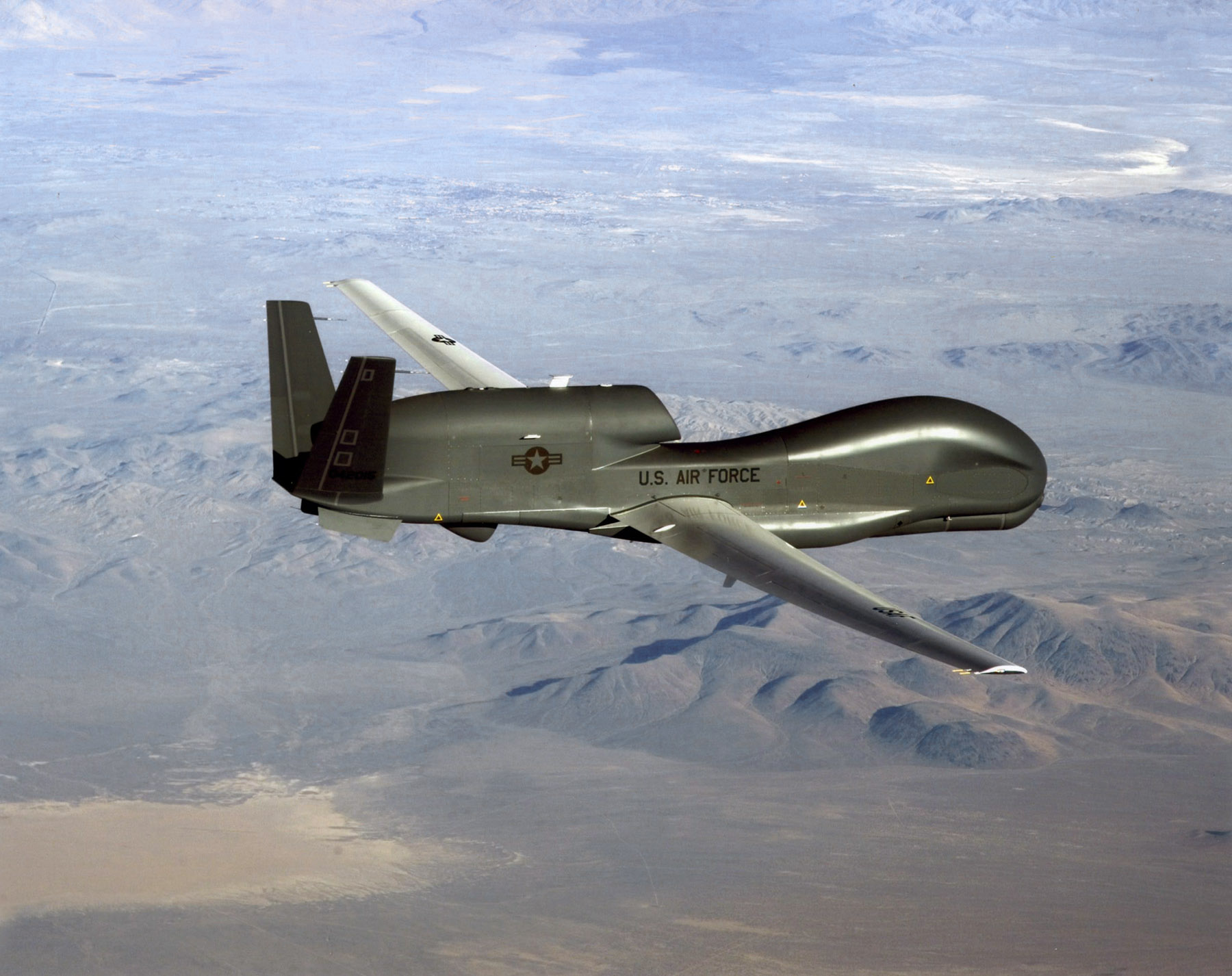
An RQ-4 Global Hawk soars through the sky to record intelligence, surveillence and reconnaissance data. (Courtesy USAF)
Curtiss-Wright Corporation’s Defense Solutions division was honored by Northrop Grumman for its role as a supplier in support of the RQ-4 Global Hawk unmanned aircraft system (UAS).
Global Hawk has flown 150,000 total flight hours supporting diverse global missions. Carrying a variety of intelligence, surveillance and reconnaissance sensor payloads, Global Hawk supports anti-terrorism, humanitarian assistance, disaster relief, airborne communications and information-sharing missions.
A ceremony was held Aug. 19 at Curtiss-Wright’s Integrated Systems facility in Santa Clarita, Calif., for the program to receive the James G. Roche Sustainment Excellence Award for a third year in a row. During the ceremony, an award was presented by Mick Jaggers, Global Hawk UAS vice president and program manager, Northrop Grumman Aerospace Sector, and accepted by Lynn Bamford, senior vice president and general manager, Defense Solutions division. The event was also attended by Rep. Steve Knight, U.S. Congressman for California’s 25th District.
(From left) Knight, Bamford and Jaggers with the award.
“We extend our sincerest congratulations to the US Air Force on this award and Northrop Grumman for their stellar job as the prime contractor on the milestone setting RQ-4 Global Hawk UAS,” said Ms. Bamford. “We take great pride in Curtiss-Wright’s role as an industry leader in providing advanced rugged electronics that help lower this important aircraft’s cost through the use of commercial-off-the-shelf technologies.”
During the ceremony, Jaggers remarked, “An aircraft as sophisticated as the Global Hawk comes together with the help of many partners, and one of the most crucial sustainment partners on the Global Hawk is Curtiss-Wright.”
The Sustainment Excellence Award is granted by Headquarters U.S. Air Force Logistics, Installations and Mission Support. It is named for Dr. James G. Roche, the 20th Secretary of the Air Force, a position he held from 2001 to 2005.
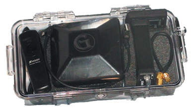
Components easily pack into a baseball-style case. Photo: Nicholas DiGruttolo
By Nicholas DiGruttolo
When asked to do a small survey job overseas, we were concerned about shipping bulky and expensive survey equipment. Shipping costs are not trivial. Add to that the real possibility that your survey equipment may be confiscated by the local authorities, as ours was in Djibouti, and the cost of shipping equipment becomes a substantial part of the overall job. There should be alternatives, especially if accuracy requirements are not stringent.
Faced with this problem for a second time, we considered a new receiver system that has many advantages over conventional survey-grade GNSS receivers: It is small, lightweight and low-cost without sacrificing performance, making it ideal for precision surveying in remote areas of the world and for traveling to the job site by commercial airline. All the components, including the tripods, rods and batteries, are constructed from commercial off-the-shelf (COTS) components. A complete base and rover kit fits in a baseball bag and weighs less than 10 kilograms. The kit is sized and approved as carry-on luggage.
The system is scalable from a simple single-frequency semi-mobile receiver for control networks and some semi-kinematic mapping applications, to a dual-frequency network RTK solution.
The system comes with free processing software that supports carrier-phase relative positioning in real time and post mission, as well as precise-point positioning (PPP) and CA-code differential correction. The software is designed with a simple user interface for easy selection of base and rover data or automatic data download of the closest Continuously Operating Reference Station (CORS) from the U.S. National Geodetic Survey database.
Complete survey set including GNSS receiver, antenna, battery and cables, fits in a small handheld plastic case. Photo: Nicholas DiGruttolo
The system fills a gap between survey applications, where centimeter-level precision is an absolute necessity, and mapping applications, where meter-level is tolerable. The product offers sub-foot precision in most cases and centimeter precision in ideal situations.
Our team recently performed topographic mapping of an oil refinery site in Saudi Arabia and surveyed a precise-elevation network in Sarasota, Fla., to research the effects of sea-level rise. The small size of the COTS components simplified transport to Saudi Arabia, eliminating additional airline baggage fees and easing import through customs. Researchers performing the sea-level study reduced field time by increasing the number of receivers needed to observe a robust vertical control network.
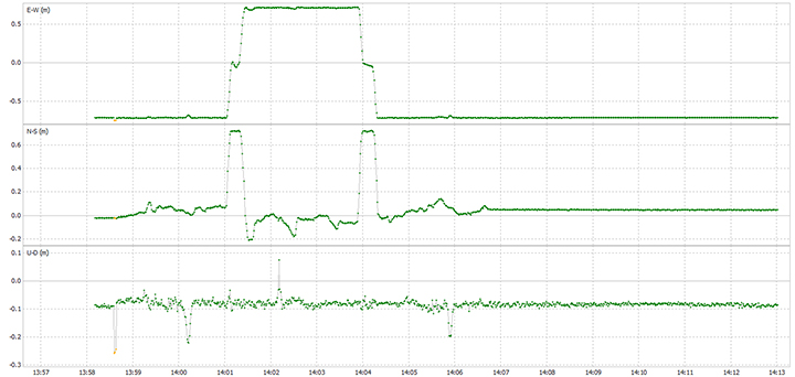
Oil Refinery. The oil refinery project entailed mounting a GNSS antenna on the roof of an off-road vehicle and driving multiple transects around the 18-kilometer perimeter of the site to record the elevation of the terrain. Kinematic data was recorded at 1 Hz using a GPS-only version of the single-frequency receiver. Baseline length to the local reference station varied from less than 1 kilometer to about 10 kilometers. The site was open desert with no overhead obstructions or sources of multipath other than the roof of the vehicle on which the antenna was mounted. Post-processing and comparison to simultaneously collected data from a high-precision survey-grade receiver revealed positional accuracy of about 5 centimeters horizontal and 10 centimeters vertical, when the system’s trajectory was compared to the truth trajectory provided by the survey-grade receiver. Figure 1 shows the difference between the two trajectories. The system’s antenna was 2 feet away from the survey-grade antenna along the driving direction of the vehicle; the trajectory was mostly in the north-south direction and hence the 0.6-m offset in the plot!
Figure 1. Antenna location difference in the sub-decimeter range between the survey-grade system and the compact low-cost system. Note: A 0.6-m offset is to be removed from the difference, as the two antennas were mounted 0.6 m apart in the vehicle driving direction.
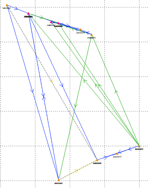
Sea Level. The sea-level-rise study required a high-accuracy vertical control network to cover a 2,500 hectare area. The purpose of the network is to determine the shortest term effects of sea-level rise with a rate of 1.8 millimeter/year in the affected area. Ten benchmarks were established throughout the area of interest, and a robust network of static observations was performed with a combination of two dual-frequency and two single-frequency receivers. The single-frequency receivers were GPS-only units where two standard 4-inch patch antennas were mounted on rods adjusted to a 0.9-meter height. The addition of two receivers provided greater redundancy and a stronger network solution in much less time than would have been possible with only one pair of survey-grade receivers. Figure 2 shows the addition of several loop ties to the network as a result of adding the two roving, lightweight receivers.
Figure 2. Sea-level rise monitoring network showing increased tie points and redundancy as a result of adding the extra lightweight precision receivers to the survey-grade receivers.
Nicholas DiGruttolo works as a field surveying manager for JBrown Professional Group Inc., Northrop Grumman Corporation, and has recently become vice president of surveying.
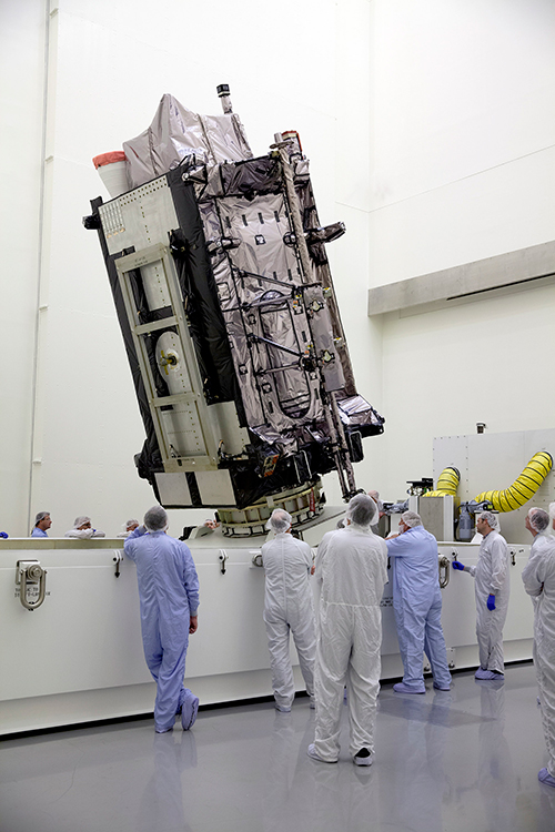
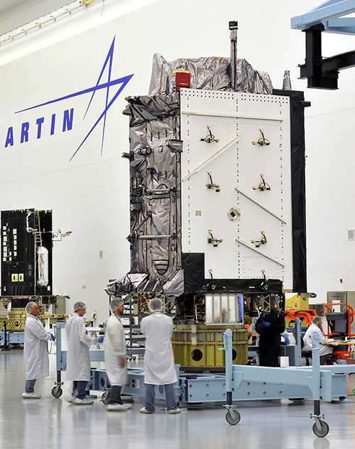
The Lockheed Martin GPS III Non-Flight Satellite Testbed (GNST).
A Lockheed Martin vice president has stated that the first GPS III satellite will likely launch in 2017, not 2016 as had been projected in the most recent update.
The company is readying the first satellite for launch availability by the end of 2015, for launch as early as the end of this year, but Space News reports that Mark Valerio, vice president and general manager of Lockheed Martin’s military space business, stated in a Feb. 18 news briefing that he expects the Air Force will schedule its launch for early 2017.
The GPS III generation of modernized satellites — with new signals, added signal strength, and resistance to interference and jamming — was originally projected to begin orbiting in 2014. Technical difficulties have delayed the program. The principal issues, those with the payload, have now been resolved, according to Valerio.
Valerio expects a firmer GPS III launch announcement for 2017 in March. He expected the final launch date “will depend on the health of the existing constellation, the availability of launch slots and synchronization with the ground system.” Ultimately, the Air Force always makes the final decision on the launch date.
Lockheed Martin is contracted to build eight GPS III satellites.
Late last year, a spokesman for the Space and Missile Systems Center said that “The first GPS III launch is tentatively considered for the first half of FY17, based on booster availability and Air Force launch priorities.”
The Air Force has put out feelers for other contractors to finish out the full generation of GPS III satellites. Lockheed Martin is building eight, with an option for four more, totalling 12; a complete constellation of III-generation satellites would require 24. Boeing Space and Intelligence Systems and Northrop Grumman Aerospace are reportedly interested.
“The best thing I can do is keep marching along the plan we have,” Valerio said. “We’re certainly not afraid of the competition.” Lockheed Martin has submitted cost-cutting proposals for the current GPS III satellite design, he added.
Ground Control
The corresponding new ground system for GPS III, the Operational Control Segment (OCX), has also fallen behind schedule. Just this month, the Air Force announced that Lockheed Martin may develop an interim control capability, a set of changes implemented upon the current control segment, the Architecture Evolution Plan (AEP), as a backup.
Michael Gilmore, the Defense Department’s director of operational test and evaluation, recently stated that OCX delays have pushed back GPS III operational testing “until after at least six, and as many as eight,” satellites have been launched into orbit. “This introduces significant risk that effectiveness and suitability deficiencies in GPS III satellites will not be discovered until it is too late to prevent their introduction to the operational constellation.”
Budget Blues
Don Jewell, GPS World’s contributing editor for defense, has written at length about the GPS III and OCX situations in his February newsletter column, “USAF FY16 Budget Plus $10B More, Please!”. We condensed some of his remarks, particular to the budget battle on Capitol Hill, for the Out in Front column of the March issue of the magazine, due out soon. Here is a further digest of those comments.
The 2016 President’s Budget, submitted in February, contains an Air Force requested a budget of $122.2 billion. This may be too little, too late.
On the satellite side of the house, GPS III has problems centering on development and delivery issues with a subcontractor. In this case, however, the whole satellite program is not failing, just a component, albeit an important one: the Mission Data Unit (MDU).
For GPS III+, the Air Force plans for a two-phased competition process: a Production Readiness competition for up to three firm-fixed price contracts to mature competitors’ production designs for a competition in a full and open competition for up to 22 GPS III Production SVs [satellite vehicles] with an expected award in FY17/18.
This sounds great if you need an entirely new GPS III system, which consists of, at a minimum, a new payload, satellite, launcher and ground C2 system. In fact, the government only needs an MDU. Failure to produce the MDU on time has delayed GPS III by 18 months to date.
More troubling are the government proposals to entertain other bids to finish the second half of the GPS III constellation. Such a competition or re-bid will take at least three years and cost hundreds of millions of dollars — and Lockheed Martin may well win again in the end
A significant added cost to the GPS budget concerns the need for a new ground C2 system if the total new systems approach is taken. If preliminary elements of the GPS space segment are developed without cross-checking the impact to the GPS control segment, technical, operational, budgetary and schedule impacts will be significant.
The already perturbed OCX budget likely has not considered the integration costs of a newly developed, yet-to-be-procured GPS III+ SV. OCX today is geared for the GPS III already contracted for, and it is failing to meet that challenge.
Budget constraints are tight and getting tighter, mandating the Air Force “do more with less” in every context. For GPS III SVs, this should — but by no means necessarily does — indicate developing an alternate MDU rather than buying a new block of GPS SVs.
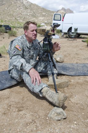
Sgt. 1st Class Justin Rotti, a combat developer from the Training and Doctrine Command Fire Cell, Fires Center of Excellence, uses a developmental handheld precision targeting device during a test at White Sands Missile Range’s 500k test site. White Sands’ terrain and environmental features make it well suited for testing systems of this type. (Photo Credit: John Andrew Hamilton, ATEC)
A new handheld targeting system developed by Northrop Grumman will enable soldiers to engage targets with precision munitions while providing digital connectivity to related military units. The unit has successfully completed developmental testing at White Sands Missile Range in New Mexico, the company said.
The Hand Held Precision Targeting Device, or HHPTD, locates, acquires, designates, marks and enables rapid target engagement with precision munitions and digital connectivity to the Joint Forces engaged in conflicts. The celestial navigation technology integrated in the system delivers improved robustness despite local magnetic variations and GPS-degraded or denied environments.
The HHPTD weighs approximately five pounds and includes a GPS receiver and internal magnetic and celestial navigation technologies, as well as an internal high-definition color day and thermal night vision sensor and an eye-safe laser rangefinder. The system is compatible with external precision azimuth and vertical angle modules and provides precision target location information with digital video output, and digital communication for target location data, plus a capability for a near infrared laser pointer.
Master Sgt. Rod Larreau, with U.S. Army Special Forces Command (Airborne), uses a targeting device at White Sands Missile Range’s (N.M) 500k Site to identify targets during a test. White Sands provided a wide range of test targets, both in the form of official target boards as well as other facilities, that could be seen from the Soldier’s observation point. (Photo Credit: John Andrew Hamilton, ATEC)
The evaluation of the HHPTD was conducted by the U.S. Army’s Rapid Equipping Force, in partnership with the Army Program Executive Office’s Project Manager, Soldier Sensors and Lasers, and demonstrated the targeting device’s effectiveness in varying terrain and temperatures, ideal conditions for enabling the accurate gauging of the technology’s capabilities.
Northrop Grumman’s Laser Systems business unit is delivering the HHPTDs to support in-theater operations of Department of Defense personnel. “This system is a lightweight, precision targeting device that addresses the targeting accuracy needed by our warfighters to help deliver today’s precision GPS munitions in all operational environments,” said Gordon Stewart, vice president and general manager, Laser Systems business unit, Northrop Grumman. “We have been uniquely successful in producing precision targeting enhancements to our systems through the use of celestial navigation technology.”
The goal is to reduce friendly fire and collateral damage by improving the ability of the soldiers to differentiate between enemy combatants and non-combatants operating in very close proximity to one another.
To best evaluate the soldier capabilities of a targeting system, soldiers at White Sands tested a variety of technologies in varying terrain and temperatures, while recording observations and data in order to help set specific, detailed development goals and objectives for the program. Meeting specified requirements is important, but including soldiers early in the evaluation process ensures acquisition professionals meet Soldiers’ needs to develop suitable equipment.
These “soldier touchpoints” are critical to developing equipment that soldiers trust and will use in combat. “Testing at WSMR [White Sands Missile Range] gives us a better idea of how a system will work when deployed to theater,” said one soldier involved with the test. “I was able to really get a feel for how the technologies would be employed downrange.”
Northrop Grumman Laser Systems has developed the HHPTD and a family of handheld laser target location systems tailored to meet mission requirements in collaboration with FLIR Systems in Goleta, California, General Dynamics GIT in Nashua, New Hampshire, and Wilcox Industries in Portsmouth, New Hampshire.
Northrop Grumman and Boeing have responded to a U.S. Air Force call for contractors interested in building a follow-on set of GPS III satellites, according to a report in Space News.
Lockheed Martin is under contract to deliver the first eight GPS III satellites, but the award for up to 22 further IIIs remains open. Difficulties with the payload for the first batch of satellites mean that although the Lockheed has three space vehicles ready, it has no signal payload to put aboard them. Subcontractor Exelis is at work on that. Delivery delays have prompted the Air Force to look about for alternatives.
Lockheed Martin itself began investigating options for its supply line last year.
Air Force “Sources Sought” Call
The U.S. Air Force issued an official “Sources sought” notice in June on a production-ready GPS space vehicle, equipped with an alternate payload, for consideration alongside the Lockheed Martin-built GPS III vehicle. The first phase of the contract would include two firm-fixed price contracts worth $100–$200 million to demonstrate a competitor to GPS III.
Key requirements are that the satellite must offer a payload alternative to that built by Exelis; the satellite must be ready to launch by 2023; and the production line must turn out two to three new satellites per year.
The second phase features a competition between Lockheed Martin and one or more other companies for as many as 22 satellites. A final contract award would be made in 2017 or 2018.
Current GPS III contractor Lockheed Martin reportedly sent an engineering team to help Exelis expedite a resolution of payload holdups, while simultaneously investigating a switch to other suppliers, beginning with the ninth satellite in the GPS 3 series. Lockheed Martin says five companies responded to its solicitation last year.
Air Force Gives Free Hand. Gen. Ellen Pawlikowski, head of the Air Force Space and Missile Systems Center (SMC), told the national Space Symposium in Colorado in June, “Obviously we want a GPS III that does what its supposed to do, delivered on time, and it’s up to Lockheed to manage its subcontractors. My view is if Lockheed is not happy with their subcontractors nav payload, and they believe that they can get a lower risk approach to delivering a nav payload by seeking a secondary source for that, then that’s clearly a decision for them to make.
“They [Lockheed ] know we are disappointed at the delays that we have seen, the technical issues that their subcontractor has had, and probably they are considering whether an alternative source could provide them a better opportunity.“
Lockheed Martin spokesman Chip Eschenfelder issued a statement: “Exelis has made good progress on the first GPS III space vehicle, SV01 navigation payload. All GPS III SV01 navigation payload components have successfully completed unit acceptance and environmental testing, with the exception of one component, the mission data unit.
“To date, significant MDU hardware testing indicates signal cross talk issues are resolved. The SV01 navigation payload forecast delivery to Lockheed Martin is fall 2014.”
Boeing built the platform and major payload components for the GPS IIF satellites and is one of three companies that received contracts in January 2013 to study how to improve the accuracy, coverage, and efficiency of GPS using smaller satellites.
Northrop Grumman Aerospace of Redondo Beach, California, has already delivered deployable antenna sets to Lockheed Martin for the first six GPS III satellites. The division has delivered more than 1,000 antennas for previous generations of GPS spacecraft, Northrop Grumman said.
Northrop Grumman has been selected by AgustaWestland to supply the LCR-110 Inertial Reference System for the new AW609 TiltRotor aircraft.
Northrop Grumman Corporation has been selected by AgustaWestland, a Finmeccanica company, to provide flight-critical inertial instruments on the new AW609 TiltRotor aircraft undergoing civil certification through the Federal Aviation Administration.
The LCR-110 Inertial Reference System and the LCR‑300A Air Data Attitude Heading Reference System have been chosen as standard inertial navigation products for the advanced AW609 TiltRotor. The LCR‑110 features a high-performance, fiber-optic gyro-based inertial measurement unit and an advanced micro-electromechanical system (MEMS) triad accelerometer. The system offers hybrid navigation via GNSS data, in addition to aircraft autonomous integrity monitoring for GPS signal integration and integrity checks. These features are essential for precise Required Navigation Performance flight operations.
The LCR‑110 evolved from the successful, longstanding LCR‑100 product family that has been selected for numerous rotorcraft and fixed-wing platforms.
The systems were developed by Northrop Grumman Navigation and Maritime Systems Division’s subsidiary in Germany, Northrop Grumman LITEF.
“This suite of combined equipment provides critical flight control and navigation data to help the aircraft achieve required availability, precision and the highest levels of integrity,” said Eckehardt Keip, managing director for Northrop Grumman LITEF. “Our products enhance precision navigation operations, improve safety margins, save weight and volume, and provide attractive commercial advantages.”
The LCR‑300A is being introduced after several years of independent research and development. The system’s MEMS gyro provides advanced attitude heading reference system performance in combination with a magnetic sensing unit. It also features directional gyro mode, which minimizes magnetic compass errors.
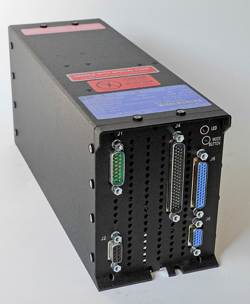
The digital air data computer module, which is embedded in the LCR‑300A, was developed by Curtiss-Wright Corporation’s Defense Solutions division. It weighs less than 0.9 pound, yet contains the pneumatic sensors and processing electronics to generate the complete International Civil Aviation Organization air data parameter set. The module is designed using the latest high stability, low drift pressure transducer technologies, providing exceptional repeatability and reliability, Northrop Grumman said.
The twin engine, fly-by-wire AW609 TiltRotor combines the benefits of a helicopter and fixed-wing aircraft into one platform. The aircraft is a natural choice for civil and para-public roles, flying above adverse weather conditions at 25,000 feet in a comfortable and pressurised cabin at twice the speed and the range typical of helicopters.
Reportstack has announced a new report on The Global Military GPS/GNSS Market 2013-2023. This report offers the reader detailed analysis of the global military GPS/GNSS market over the next 10 years, alongside potential market opportunities to enter the industry, using detailed market size forecasts, Reportstack said.
A satellite navigation system provides GPS positioning from a global perspective, and is therefore of utmost importance for modern-day military operations, which rely on accurate real-time data on hostile forces in order to carry out precision attacks, Reportstack said. It is here that GPS/GNSS devices assume an important role, as they are imperative to transfer signals from these satellites back to earth.
The U.S. is the highest spender on military GPS/GNSS navigation, and is responsible for 42.9% of the global military GNSS devices market. Others major spenders in this sector include Russia, the UK, China and India. In July 2013, India launched the IRNSS-1A, the first of seven satellite constellation to be deployed under the Indian Regional Navigation Satellite System (IRNSS) program to be completed between 2015-2016. And China’s BeiDou is scheduled to be operational by 2020.
Another factor driving the market is the integration of satellite navigation technology with other navigation systems, such as the inertial navigation system (INS) and gyro, as GPS devices are to be used in order to decipher data correctly, Reportstack said.
The increasing demand for satellite navigation and communications is driven primarily by the desire of militaries to monitor more areas and derive accurate information by a range of GNSS receivers/sensors in the shortest time possible. Major military aircraft and helicopters are dependent on GPS embedded INS systems for effective navigation. Similarly, naval vessels and guided munitions are increasingly relying on the collaboration of laser, gyro, INS, and satellite navigation technologies to derive accurate real time data.
Furthermore, it has been observed that the usage of standard positioning services/open service receivers, which use unencrypted signal for non-combat purposes has increased, and is expected to drive demand and encourage expenditure, Reportstack said. The military GPS/GNSS technology is expanding its horizon beyond the basic characteristics of navigation and tracking. The use of GPS, in conjunction with a number of software applications, has expanded its use in military operations. A number of new technologies are now embedded with GPS receivers to produce a more sophisticated military tool.
Recently, a Swiss-based company developed a device called GPS Log Book based on u-blox technology. The new device has extended the scope of GPS technology to the administrative side of military operations. It provides an easy way for military drivers to automatically keep an accurate travel log book which can be securely accessed later from anywhere via a web interface. Information logged includes route, speed, and distance traveled. It also keeps a close record of fuel used by the vehicle, based on the distance traveled at various speed levels.
The advent of Differential GPS (DGPS), an enhancement to GPS, which provides improved location accuracy, from the 15-meter nominal GPS accuracy to approximately 10 cm, has further expanded the scope of GPS in missile technology. The intercontinental ballistic missiles, which are capable of hitting targets across thousands of miles navigation, use inertial navigation with DGPS receivers. The advent of DGPS is expected to be one of the most significant steps in accurate missile targeting for militaries across regions.
The companies mentioned in this report are Northrop Grumman, Raytheon, Rockwell Collins , Lockheed Martin, ITT Exelis, Thales, and BAE Systems. More details and table of contents about this report can be found by visiting The Global Military GPS/GNSS Market 2013-2023 report.
Northrop Grumman Corporation is applying a modular, open architecture approach throughout its product portfolio, allowing for rapid addition of new avionics capabilities for warfighters. Northrop Grumman is already applying the FACE Reference Architecture and interfaces to existing programs and products, including an embedded GPS/inertial navigation system for the Joint Precision Approach and Landing System and a highly adaptable mission equipment package.
Northrop Grumman will leverage the corporation’s expertise in open architecture to implement FACE requirements for both current and future programs, including the Black Hawk H-60L Digital Performance Plan program and Tech-Refresh Mission Computers for the H-1 Upgrade program.
The company plans to participate in demonstrations that will promote maturation of the FACE Reference Architecture by enabling companies to deploy their products in a functional, standardized FACE software environment.
Also, the company’s Transport Services Segment aligns with the FACE Technical Standard requirements and provides a standard interface that allows portable avionics applications to be integrated with a variety of architectures and aviation platforms.
“An open architecture approach is critical to the affordability, innovation and effectiveness of avionics systems,” said Ike Song, vice president of Northrop Grumman’s Situational Awareness Systems business unit. “We are using performance-proven solutions from across our corporation to offer highly flexible, affordable products that support reuse on various platforms.”
Northrop Grumman’s Common Mission Management System (CMMS) establishes a common foundation for affordable control systems to support a variety of the company’s unmanned products. Based upon open architecture standards and standard off-the-shelf commercial hardware and software infrastructures, the Northrop Grumman CMMS product line avoids the need for dedicated, custom-built command and control systems for individual platforms. Also, the Northrop Grumman CMMS product line enables pilots to operate a variety of dissimilar unmanned platforms using the same informational displays and control features, thereby improving mission effectiveness while reducing training requirements.
With its expertise in unmanned aerial systems (UAS), the Northrop Grumman team was instrumental in leading the FACE Consortium’s effort to align with the UAS Control Segment (UCS) information model, establishing a common conceptual data model and metamodel as a framework that defines rules and conventions for developing interoperable software components for unmanned aerial system ground control stations. Further collaboration under the UCS/FACE Memorandum of Agreement is anticipated in aligning the FACE and UCS standards.
Northrop Grumman is a leading global security company providing innovative systems, products and solutions in unmanned systems, cyber, C4ISR, and logistics and modernization to government and commercial customers worldwide.
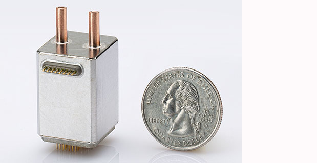
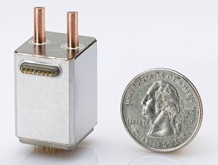
Northrop Grumman Corporation has developed and demonstrated a new micro-Nuclear Magnetic Resonance Gyro (micro-NMRG) prototype for the Defense Advanced Research Projects Agency (DARPA), providing precision navigation for size- and power-constrained applications.
The development of a hermetically sealed micro-NMRG that meets precision navigation requirements along with a successful prototype demonstration marks the fourth and final phase of DARPA’s Navigation-Grade Integrated Micro Gyroscopes (NGIMG) program. The culmination of the eight-year program is a micro-NMRG that offers near navigation-grade performance for the next generation of high-precision inertial sensors.
Northrop Grumman’s micro-NMRG technology uses the spin of atomic nuclei to detect and measure rotation, providing comparable performance to a navigation-grade fiber-optic gyro in a small, lightweight, low-power package. Additionally, the gyro has no moving parts and is not inherently sensitive to vibration and acceleration. The technology can be used in any application requiring small size and low power precision navigation, including personal and unmanned vehicle navigation in GPS-denied or GPS-challenged locations.
“Our miniature gyro technology offers unprecedented size, weight and power savings in a compact package, exceeding program requirements,” said Charles Volk, vice president of Northrop Grumman’s Advanced Navigation Systems business unit. “This important technology can help protect our warfighters by offering highly accurate positioning information, regardless of GPS availability.”
The NGIMG effort is part of DARPA’s Micro-Technology for Positioning, Navigation and Timing program that aims to develop technology for self-contained, chip-scale inertial navigation and precision guidance. Northrop Grumman began the first phase of the NGIMG effort in October 2005 and has consistently met or exceeded the performance goals of each program phase.