Norway has electronic proof that Russian forces disrupted GPS signals during recent NATO war games, according to a report in Reuters news service.
The Scandinavian country and North Atlantic Treaty Organization (NATO) member has demanded an explanation from its neighbor. “We recognize Russia’s right to exercise and train its capacities [but] it is not acceptable that this kind of activity affects security in Norwegian air space,” stated the Norwegian defense ministry.
Finland and Norway published claims in November that Russia may have intentionally disrupted GPS signals before and during NATO military exercises. The radio-frequency interference also affected the navigation of civilian air traffic in the Arctic. Both countries protested to Russia, which dismissed the allegations.
“We gave them the proof,” Norwegian Defence Minister Frank Bakke-Jensen stated publicly. Russia demurred, with Foreign Minister Sergey Lavrov terming the Norwegian allegations “a fantasy,” and said it would conducts its own investigation. “To be a neighbor of Russia you need to be patient,” added Bakke-Jensen.
Could Russia have targeted Norway intentionally? The minister replied: “They were exercising very close to the border and they knew this will affect areas on the other side.”
November saw NATO’s largest exercise in decades, involving forces from 31 countries in an area stretching from the Baltic Sea to Iceland.
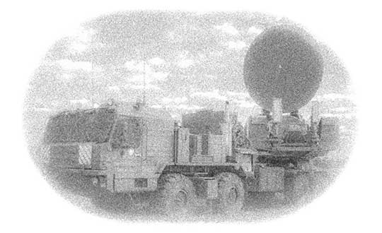
Above: Krasukha jammer mounted on a heavy-duty truck, part of the radio electronic warfare unit (EW) of the Western Military District. (Photo: Ministry of Defense of the Russian Federation)
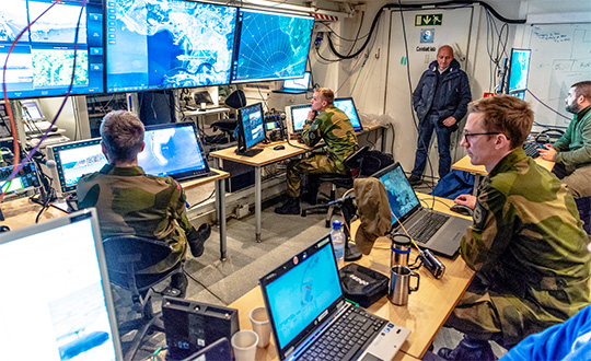
NATO conducted its largest military exercise since the Cold War in the frigid waters and icy mountains of Norway Oct. 25-Nov. 7.
During the final days of the Trident Juncture exercise, GPS signals guiding ships, aircraft, tanks, trucks and troops began to fail. Tracking screens flickered and positions were suddenly wrong from a few meters to hundreds of kilometers.
Civilian airliners, cars, trucks, cargo ships and smartphones operating in and around Norway and Finland experienced similar disruptions. Norway-based airline Wideroe told The Barents Observer that its pilots were reporting the loss of GPS signals when flying to airports in northern Norway and Finland. Airfields affected ranged from Kirkenes, on Norway’s border with Russia, to Lyngen in Troms, much further west.
Russia is the chief suspect of jamming the signals in reaction to the massive size and proximity of the military exercises. Russia also has recently conducted massive military exercises in the Baltics.
“It is possible that Russia has been the disrupting party in this,” Finland’s Prime Minster Juha Sipila told local media. “Russia is known to possess such capabilities.”
Trident Juncture involved all 29 NATO alliance members. Neutral Sweden and Finland also took part amid growing uncertainty over Russia’s ambitions in the tense region.
Fugro has won a long-term contract to provide GNSS-based rig positioning services to Statoil Petroleum AS.
The contract includes positioning of all the Statoil operated rigs on the Norwegian continental shelf and associated Statoil vessels.
Fugro’s specialized satellite positioning systems, utilizing all available navigation satellites (GPS, GLONASS, Beidou and Galileo), will be permanently installed on the Statoil-operated rigs and vessels.
The robustness and accuracy (better than 3 centimeters) of these satellite systems, in conjunction with Fugro’s latest navigation software and technology developments, will ensure the best possible service for Statoil, Fugro said.
Developments in technology will bring two significant benefits to Statoil: by remotely configuring the offshore systems from Fugro’s onshore bases, mobilization time will be reduced and fast-track operations will be enabled.
Fugro will providing GNSS positioning services to Statoil Petroleum’s oil rigs and vessels. (Photo: Fugro)
Berit Sagatun, commercial manager for Fugro, cited the company’s track record in the delivery of innovative rig positioning systems.
“For decades Fugro has been at the forefront of the rig positioning market in Norway,” Sagatun said. “Our knowledgeable and responsive project management team, combined with our highly skilled and experienced offshore personnel, ensures safe and efficient operations for Statoil.”
Fugro has been awarded six contracts by the National Maritime Safety Authority (NMSA) of Papua New Guinea. The hydrographic survey packages are expected to contribute to capacity development in the country, which has more than 5,000 kilometers of coastline.
The surveys will be conducted using a combination of Fugro’s Airborne Lidar Bathymetry (ALB) and multi-beam echo sounder (MBES) sensors, and a seamless dataset will be delivered to the NMSA.
“As a pioneer of ALB development, Fugro has a solid track record in applying this advanced technology for mapping shallow water environments safely and cost- effectively,” said Paul Seaton, Fugro’s regional business development manager for Asia Pacific.
The surveys in deeper waters will be performed by vessel, and Fugro will also conduct a comprehensive tides campaign throughout the survey area.
The contracts are part of the Asian Development Bank-funded Maritime Waterways Safety Project that aims to improve the safety and efficiency of the country’s international and national shipping in coastal areas and waterways. By improving the maritime environment and making coastal shipping safer, the project will facilitate travel, trade and tourism for rural communities.
Fugro has also begun a hydrographic survey encompassing an area of Norwegian waters of 15,000 square kilometers. The contract was awarded by the Norwegian Hydrographic Service and has a value of 34.5 million NOK (approximately €3.8 million).
The survey is part of the MAREANO program, for which Fugro has successfully completed a number of surveys since 2006. The Norwegian program maps depth and topography, sediment composition, contaminants, biotopes and habitats. It takes place in the Barents Sea with various areas located above the 78th parallel and typical water depths ranging from 80 to 3,500 meters.
The University of the Bundeswehr Muenchen and the Norwegian Space Centre are organizing the International Summer School on Global Satellite Navigation Systems 2017.
Longyearbyen, Norway.
This year the Summer School will be held at Longyearbyen, Svalbard – Spitsbergen, Norway, Sept. 4-15. Lectures start the morning of Sept. 5 and end Sept. 14 following dinner.
The Summer School is open to graduate students, Ph.D. candidates, early-state researcher and young professionals seeking to broaden their knowledge.
Svalbard is an Arctic wilderness series of islands comprising the northernmost part of the Norwegian territories. It is mostly uninhabited, with only about 3,000 people. Longyearbyen, however, is a living community with an airport, a university, a hospital, schools, shops, restaurants, pubs, hotels, and the world’s largest commercial ground station.
The summer school will provide key information, fresh ideas, basics, innovative approaches and practical advice on such topics as:
Basics of satellite navigation
Ionospheric and tropospheric effects on GNSS
Carrier-phase positioning
GNSS RF link performance
GNSS signals
GNSS receivers
Leadership and team effectiveness
GNSS threats and countermeasures
Navigation in GNSS denied environments
Cyber safety for civilian navigation
Become a GNSS entrepreneur
Location data and raw measurements in Android
IPR and patents in GNSS
Liability issues in GNSS
Railway high-integrity navigation overlay system (RHINOS)
Multi-frequency multi-system GNSS
Evolution of GNSS, in particular of the Galileo system
Satellite-based augmentation system (SBAS) and receiver autonomous integrity monitoring (RAIM, ARAIM)
GNSS space service volume and deep space navigation
The summer school will be held in cooperation with the European Space Agency and the Joint Research Centre, as well as, ISAE Supaero, Stanford University and TU Graz.
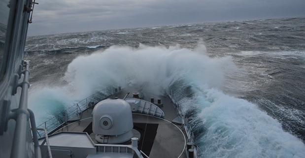
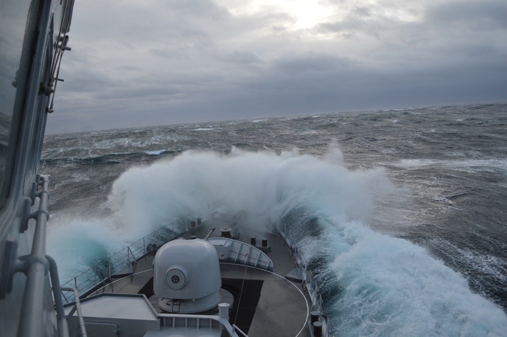
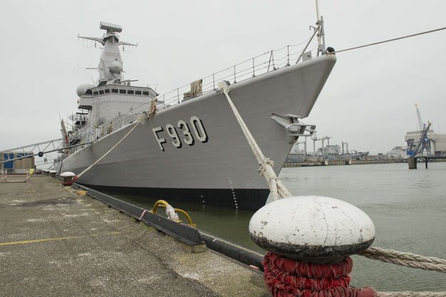
Belgian frigate Leopold I-F930 in rough water off Norway during Galileo maritime testing. In December 2013 the frigate participated in the first maritime trials outside mainland Europe of the Galileo satellite navigation system.
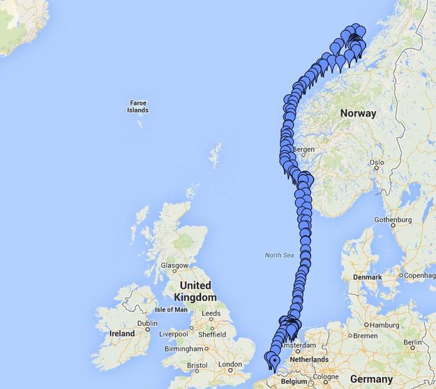
Results are being processed from the first Galileo maritime trials outside of mainland Europe. The long-range, high-latitude testing spanned the North Sea, following the same historical sailing route that Viking dragon-ships used 1200 years ago.
Ancient manuscripts record Viking navigators relied on “sunstones” to find their way — archaeologists believe these may have been polarizing crystals to pinpoint the Sun even in overcast skies.
By contrast, Belgian frigate Leopold I-F930, participating in the end-of-year trials, carried the most up-to-date equipment possible, with multiple Galileo receivers for both its public Open Service (OS) and secure Public Regulated Service (PRS).
“Galileo is in a transition between its In-Orbit Validation (IOV) phase and follow-on Full Operational Capability phase,” said Miguel Manteiga Bautista, head of ESA’s GNSS Security Office. “This means we are engaging in all kinds of experimental demonstrations of all Galileo services, in particular PRS, which offers the most highly accurate positioning and timing performance, but with access strictly restricted to authorized users.”
The recorded course of Belgian frigate Leopold I-F930 during the first high-latitude trials of Europe’s Galileo satellite navigation system. The frigate sailed first from the Dutch marine base of Den Helder on 4 December 2013 to Stavanger in Norway. From there it progressed north in very rough seas with 10-m high waves, coming close to the Arctic circle on December 17 — a first for Galileo PRS observations — before heading homeward.
The frigate sailed first from the Dutch marine base of Den Helder on December 4, 2013, to Stavanger in Norway. From there it progressed north in very rough seas with 10-meter-high waves, coming close to the Arctic circle on December 17 — a first for Galileo PRS observations — before heading home.
The testing provided tangible in-situ evidence of Galileo signal stability across both its operating frequencies up at high latitudes, equaling low satellite elevations in the local sky.
Following the completion of earlier road, then flight, testing last summer and autumn, the last challenge for Galileo’s IOV phase was to engage in a long-term maritime trial into high latitudes. The testing was performed as part of the PRS Participants to IOV project jointly managed by ESA and the European Commission, in collaboration with the European GNSS Office Agency and several Member States possessing PRS test receiver technology.
The trials were performed by the Royal Military Academy of the Belgian Ministry of Defence, the UK Space Agency in collaboration with Nottingham Scientific Ltd. and ESA, to ensure PRS signals were available whenever the four Galileo satellites in orbit came into view.
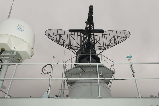
Two receivers, seen either side of the main antenna, were carried by Belgian frigate Leopold I-F930 during high-latitude testing of both Galileo’s publicly-available Open Service and secure Public Regulated Service in December 2013.
A dual-test setup was fitted to the frigate at Den Helder. Belgium connected a PRS receiver and an OS receiver, both manufactured in Belgium by Septentrio NV, to a common antenna. The PRS receiver recorded raw PRS measurements on both frequencies while the OS receiver logged data from openly available Galileo, GPS and GLONASS signals at one-second intervals.
Nottingham Scientific installed its Ultra system configured to record radio-frequency samples, allowing the detailed post-processing of Galileo OS and PRS signals.
“As this was a first use of PRS equipment outside EU borders, the security issues were quite challenging,” said Bruno Vermeire, head of the Belgium Competent PRS Authority (Federal Public Service of Foreign Affairs). “Several partners from different countries and industries were involved. At all times the necessary security was assured, though this could not have been possible without the dedicated joint commitment of all partners.”
David Parker, head of the UK Space Agency, commented, “This test is a significant milestone on the road to demonstrating early PRS capability across a range of platforms. It should serve as a model for wider international collaboration between national governments and industry to prove and demonstrate PRS in different applications.”
Belgian frigate Leopold I-F930 at Den Helder dockyard in the Netherlands.
Alain Muls, professor of the Royal Military Academy of Belgium, faced the challenge of coordinating the maritime trial without interfering with the normal operations of the frigate. “Thanks to the cooperation of with the Maritime Component of the Belgium Defence, in particular that of the frigate’s commander and crew, preliminary results look very promising. Reception of Galileo’s OS and PRS navigation services have been practically demonstrated under severe maritime conditions with waves of up to 10 meters in height.”
“This activity is a truly collaborative effort at all levels. The trial involved UK and Belgian governments and industry partners with support from different European bodies as well as officials from the Netherlands and Norway,” said Mark Dumville, Nottingham Scientific general manager. “This team effort has enabled the concept of radio-frequency sampling processing of Galileo PRS signals to be tested in real-world operational environments. We have confirmed that the prototype receiver is now ready to support European governments and associated PRS applications.”
The collaborative nature of this trial was formally recognized as the Leopold I-F930 reached Stavenger. Under the supervision of Belgium’s CPA, Jochen Devadder, the country’s Ambassador to Norway Michel Godfrind provided a Norwegian delegation with details of the testing.
Results from the trial will guide future Galileo developments for years to come.
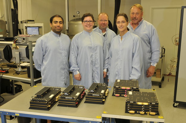
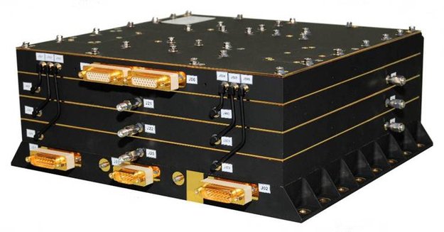
Galileo hardware ready for delivery. The last three Search and Rescue Transponders (SARTs), left, and the last two Frequency Generator and Upconverter Units (FGUUs), right, units produced by Kongsberg Norspace under the first work order for the first 14 Galileo Full Operational Configuration (FOC) satellites being prepared for shipment to Surrey Satellite Technology Ltd, seen together with some of the key project team members.
A trans-European production line is progressively transforming the Galileo satnav system into a working reality, according to the European Space Agency (ESA). The 22 satellites so far contracted to join the four already in orbit are having their payloads manufactured at Surrey Satellite Technology Ltd. in the UK, which are then integrated to their satellite platforms at OHB in Germany. Finally, each complete satellite is tested at ESTEC in the Netherlands for launch from Europe’s Spaceport in French Guiana.This main manufacturing process is fed by smaller but no less crucial production lines all across the continent, run by specialized companies supplying essential building blocks to Galileo’s prime contractors, ESA said.
The old Norwegian naval town of Horten, just south of Oslo, is home to Kongsberg Norspace, a 95-strong company contributing two key elements to these next 22 Galileo Full Operational Capability satellites.
“We won the contracts to supply the Frequency Generator and Upconverter Units (FGUUs) and Search and Rescue Transponders (SARTs) for all the Galileo FOC satellites,” explains Sverre Bisgaard, CEO of Kongsberg Norspace.
The shoebox-sized Frequency Generator and Upconverter Units (FGUU) is a pivotal item of equipment that takes the outputs of the satellite’s adjacent Navigation Signal Generator Unit and converts them into L-band signals across Galileo’s three spectral bands. It is these signals that end up guiding Galileo users through their receivers.
The shoebox-sized FGUU is a pivotal item of equipment, effectively giving Galileo its voice. “It takes the outputs of the satellite’s adjacent Navigation Signal Generator Unit and converts them into L-band signals across Galileo’s three spectral bands. It is these signals that end up guiding Galileo users through their receivers,” Bisgaard said.
“These signals end up being very low power by the time they reach the ground, so maintaining the signal quality is key, in terms of power range, frequency shape and low noise. The FGUU actually relies on Galileo’s atomic clocks to keep accurately locked on its set frequency. It also actively determines which of the clocks and other redundant subsystems it should employ at any one time for optimal operations,” Bisgaard said.
Kongsberg Norspace’s second, similarly sized contribution is the SART, which picks up emergency distress calls from the ground or sea and relays them to the nearest rescue centre, while also sending a return-link message that help is on the way. Galileo’s search and rescue capability marks a significant enlargement of the international Cospas–Sarsat system, which has been active for more than three decades and rescued thousands of lives.
The company won the SART contract having previously supplied similar transponders to ESA’s Meteosat Second Generation satellites.
“The SART’s job as a transponder is just to relay messages, theoretically a simple task but requiring clever design to make it work,” adds Mr Bisgaard. “The SART is operating across noisy frequencies, and has to recognise, filter and amplify the very weak messages in question without missing anything.
“So both FGUU and SART have a need for effective filtering in common, to ensure that they are processing the right frequencies with the right signal shape without any garbling. This filtering is performed physically, based on ‘Surface Acoustic Wave’ (SAW) technology.
“SAW makes use of the physical effect called ‘piezoelectricity’ – if an electrical field is applied to quartz it is converted to a mechanical or acoustic wave. By converting our electrical signal in this way then converting it back again the signal can be filtered and shaped as desired. This is one of our key technologies and in fact ESA recognises us as a preferred supplier for SAW systems.”
While the FGUU has embedded redundancy and the SART is a non-redundant unit, one of each design is being supplied for each Galileo satellite, a total of 44. Batch production is a shift from how the space industry traditionally operated, with bespoke designs for each individual satellite, but Kongsberg Norspace has had a lot of experience working in such a way.
“We’ve had similar series contracts in the past, for instance contributing 48 identical units to five satellites of the Russian Express-AM series and up to 12 units per satellite for the 64-satellite Globalstar low-Earth orbit telecom constellation.
“We’ve already delivered units to SSTL for the first 14 satellites, which was the first contract won, with the next eight in production. It is SSTL who set the technical requirements and give us information on the interfaces with the other items of equipment, such as the clocks and navigation signal generator unit. We deliver directly to SSTL where the integration is performed.”
Norspace has been doing business for just under three decades, originally formed as a subsidiary of another company before being spun out. In 1986 it won its first ESA contract, supplying systems for the Agency’s ERS-1 remote sensing missions, subsequently diversifying into the US telecommunications market under the ownership of Alcatel.
A decade ago a management takeover took place, with the company bought by Kongsberg in 2011. Upwards of 150 satellites rely on hardware supplied by the company.
“Telecom missions remain an important part of our business, but Galileo is becoming more important – it represented 40% of our sales during the last couple of years.
“We have been involved with Galileo since the start, supplying equipment for the initial testbed systems, then the GIOVE-A and -B test satellites and the initial In-Orbit Validation quartet of satellites. We hope to maintain our involvement into the future as Galileo evolves, so we are discussing about joining with primes to prepare for future bids.
Altus Positioning Systems has been selected by the National Courts Administration of Norway, Land Consolidation Court Division, to provide APS-3G series GNSS survey receivers to modernize its fleet of about 80 receivers.
NavSys AS, Altus’ sales representative in Norway, won the tender in a highly competitive bid.
“The Land Consolidation Court’s rigorous tests for the selection process were completed in demanding environments, including under heavy tree canopies,” said Arnt Tore Sund, managing director of NavSys. “The price-performance relation and the quality of the Altus APS-3G receivers, together with the comprehensive customer support, detailed product knowledge and deep technical understanding of the NavSys team, strongly contributed to this successful outcome.”
The Land Consolidation Court’s 34 district offices will use the Altus APS-3G systems for geodetic, cadastre and land consolidation applications and for supporting the resolution of legal disputes.
The Altus 136-channel APS-3G is a compact, lightweight, portable GNSS RTK receiver. It is based on the high-precision Septentrio multi-frequency, multi-constellation AsteRx3 engine. The unit is completely configurable from the data collector via Bluetooth for either base or rover operation with the internal UHF radio or for network rover operation with the internal quad-band GSM/GPRS modem. Its removable 2-GB SD card enables plug-and-play of raw data transfer for post processing.
The APS-3GX model, which also is being delivered, optionally provides a port to a remote lightweight antenna that can be mounted on a five-meter pole to improve reception of the GNSS signals by raising the phase center when under dense vegetation.
Neil Vancans, president and CEO of Altus Positioning Systems, commented, “This substantial order, obtained through the efforts of our valued sales partner in Norway, is an important validation of our APS-3 technology, which offers significant competitive benefits and advantages over other higher-priced GNSS survey receivers on the market today.”
The Land Consolidation Court of Norway is a special court established under the Land Consolidation Act to adjudicate boundary disputes among property owners and freeholders in land consolidation cases. Mapping and other technical work is done by staff from the court so that decisions made are documented for the future. The technical staff has competency to do all the technical work in each case handled by the court.