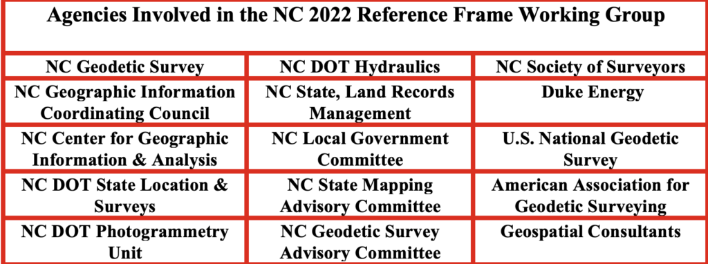
As noted in my previous newsletter, NC RFWG agencies are proactively conducting self-assessments of their needs and processes to identify challenges and opportunities early, enabling a smooth transition and sustained operational efficiency. The working group meets monthly to review progress on activities.
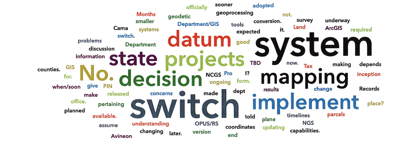
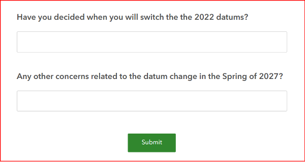
One key task of the working group was to develop a short online questionnaire. The goal was to open a dialogue with geospatial professionals and better understand their readiness for the upcoming modernization of the National Spatial Reference System (NSRS).
The questionnaire was designed to address the following key questions:
Are you prepared to implement the new NSRS once the National Geodetic Survey (NGS) officially adopts it?
Do you have the necessary tools and resources in place to ensure a smooth transition?
Has your organization established a timeline for transitioning to the modernized NSRS?
What concerns do you have regarding the transition to the new NSRS?
The section titled “Introduction of North Carolina Questionnaire” explains the purpose and background of the survey, while the section titled “North Carolina Online Questions” presents the list of questions included in the questionnaire.
Introduction of the North Carolina Questionnaire
This questionnaire seeks stakeholder input on the upcoming modernization of the National Spatial Reference System (NSRS). Your feedback is welcome on the proposed questions, as well as any concerns about the datum transition, tools (such as updated NCAT, OPUS, and SPCS2022), data transformation strategies, workflow impacts, and preparation needs.
The National Geodetic Survey (NGS) is replacing the North American Datum of 1983 and the North American Vertical Datum of 1988 with new plate-fixed terrestrial reference frames (NATRF2022, PATRF2022, CATRF2022, and MATRF2022) tied to the International Terrestrial Reference Frame 2020, along with the new vertical datum, the North American-Pacific Geopotential Datum of 2022.
In spring 2027, new horizontal and vertical datums will be implemented:
Horizontal
North American Terrestrial Reference Frame (NATRF2022)
Replaces the North American Datum of 1983 (2011)
Vertical
North American-Pacific Geopotential Datum of 2022 (NAPGD2022)
Replaces North American Vertical Datum of 1988
Units
14B NCAC 03 .0602 REQUIRED FOOT CONVERSION
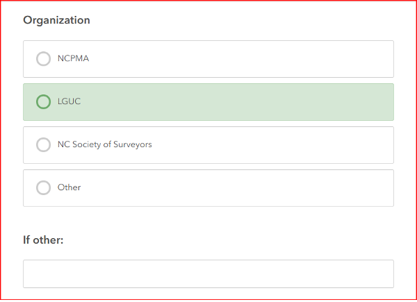
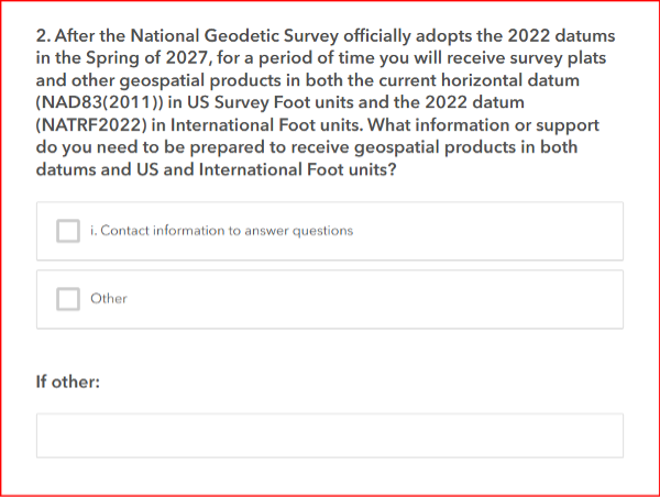
North Carolina Online Questions
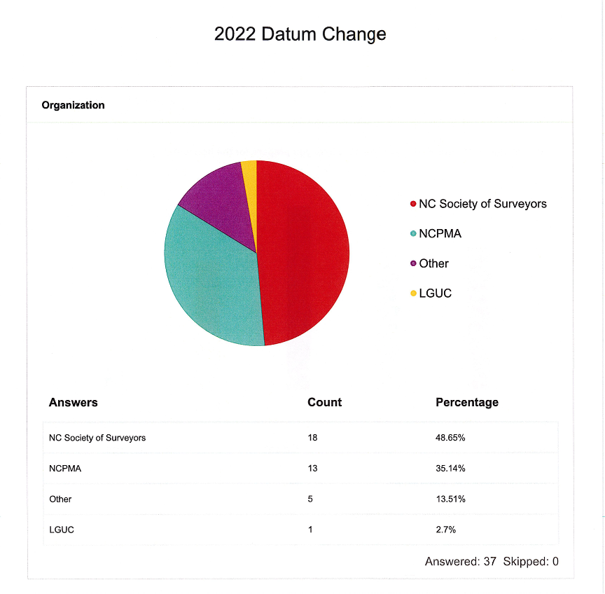
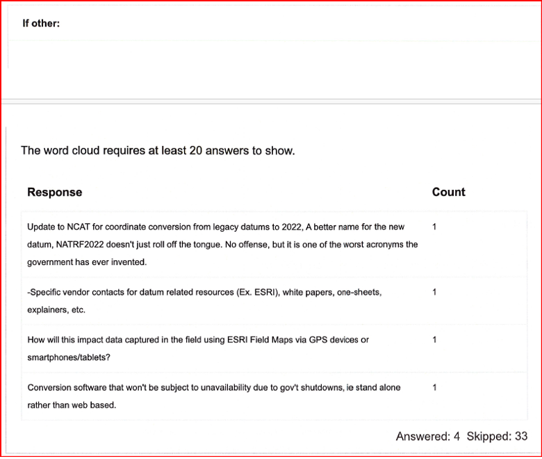
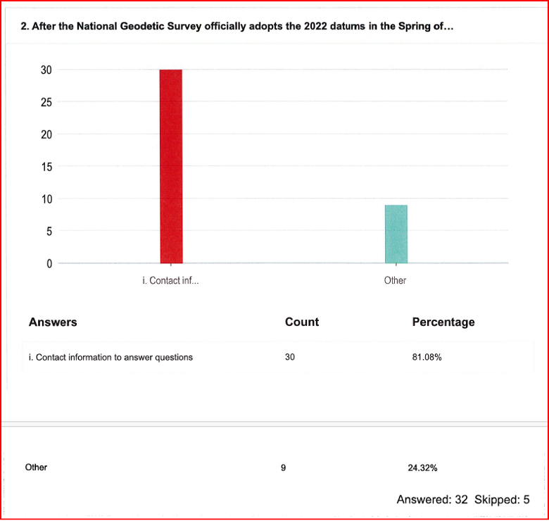
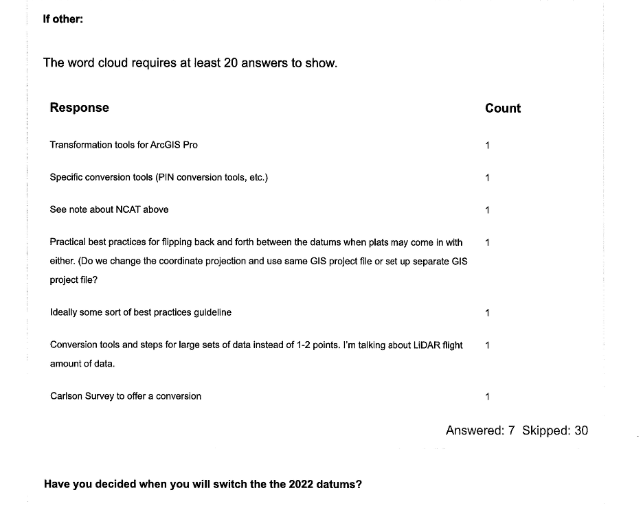
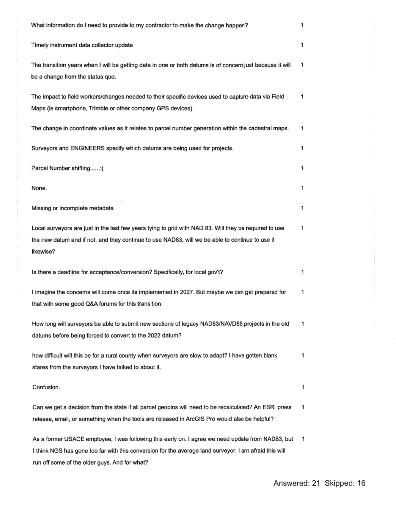
The section titled “Results of North Carolina Online Questionnaire” summarizes the survey responses collected as of April 27, 2026.
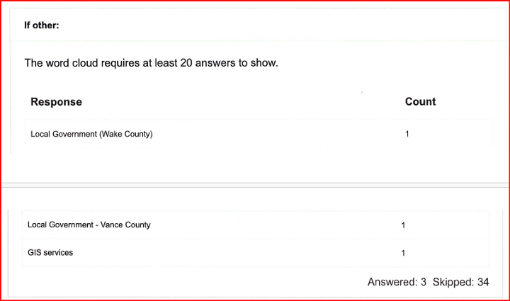
[Note: NCPMA refers to the North Carolina Property Mappers Association, and LGUC refers to the North Carolina Local Government Committee.]
Results of the North Carolina Online Questionnaire
(April 27, 2026)
This questionnaire solicited input from the North Carolina Property Mappers Association (NC PMA), the North Carolina Geographic Information Coordinating Council (GICC), and the North Carolina Local Government Committee (LGC). Although focused on North Carolina, the results may benefit other working groups. The NC working group is reviewing all feedback—especially regarding the Spring 2027 datum change—and will develop materials to address it.
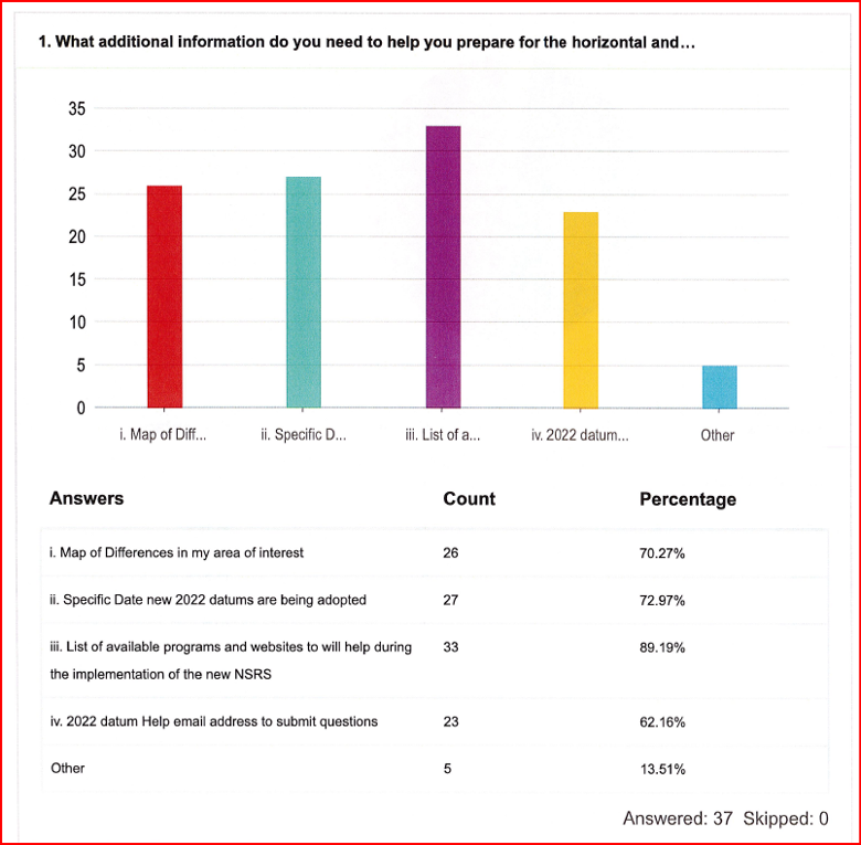
In addition to the questionnaire, the working group prepared a short guidance document on the new reference frames for local governments and state agencies. It outlines how to prepare for the 2027 datum change and covers:
Preliminary steps for transitioning when NGS and North Carolina officially adopt the new datums in 2027.
Actions users can take now to ready NSRS‑referenced data for the modernized NSRS and the shift from U.S. Survey Foot/International Foot.
Estimated coordinate changes with the 2027 adoption of:
North American Terrestrial Reference Frame (NATRF2022)
North American-Pacific Geopotential Datum of 2022 (NAPGD2022)
New national geoid model (Geoid2022)
North Carolina State Plane Coordinate System of 2022 (SPCS2022)
Current NC statewide digital orthoimagery acquisition cycle and statewide lidar collection schedule.
How the NC CORS and Real-Time Network (RTN) will support the modernized NSRS.
Web links to more detailed resources.
The working group is developing a case study on preparing a FEMA Elevation Certificate using the modernized NSRS (NATRF2022 and NAPGD2022). It will be featured in upcoming newsletters. The North Carolina Geodetic Survey will host the materials on its website, and I’ll share the public link once it’s available.
As president-elect of the American Association for Geodetic Surveying (AAGS), I participated in a joint quarterly meeting with the National Geodetic Survey (NGS), the National Society of Professional Surveyors (NSPS) and AAGS on April 25.
I invite you to visit the AAGS website and consider joining our monthly board meetings, which are held on the second Tuesday of each month. All are welcome to attend. If you are interested, email me at [email protected] to be added to the attendee list.
Now, for some updates from the joint quarterly meeting.
During the meeting, I provided an update on the Certificate for Geodetic Surveying program, which has been under development by AAGS and is expected to be available by the end of the year. The program is designed to meet the needs of surveyors and others that perform spatial analyses and computations using geodetic methods.
Tim Burch, executive director of the National Society of NSPS, wrote the following in an April 23, 2025, xyHt article:
“To the average professional surveyor, the term “geodesy” does not exist in their everyday conversations about the business. While the use of state plane coordinates has expanded greatly with the development of GPS/GNSS receivers and RTK/RTN connectivity, the mathematics and “black magic” of geodesy remains an enigma to most of the profession.
However, the ongoing progression of technology within surveying instruments has expanded the need for understanding how geodesy works. Our practitioners are faced with expanding their knowledge and expertise of geodesy and thus have put a new challenge on them to find teachers and/or mentors to provide training on the datums and techniques.”
This is exactly what AAGS is attempting to do with the Certificate for Geodetic Surveying program. The information below includes the program description and content. AAGS has developed a set of questions that will determine if an individual has demonstrated a minimum competence in understanding and applying geodetic surveying concepts. AAGS is working with NSPS, who will be administrating the program for AAGS. The status and updates of this program are provided at the AAGS Monthly Board meetings. Come join us to hear more about the program and other AAGS activities.
Certification for Geodetic Surveying
Program description and content. Certification for Geodetic Surveying is official recognition that a person has demonstrated to the satisfaction of the Certification for Geodetic Surveying Board that he or she is minimally competent to perform spatial analyses and computations using geodetic methods. It is not intended to certify scientists performing research in geodesy. Rather, it is for individuals who use geodetic concepts and techniques to solve practical problems as a part of performing their work. Typical practitioners include geodetic surveyors, geodetic/geomatics engineers, geospatial software developers, geographic information systems (GIS) professionals, and geospatial data managers. The focus is more on the use of applied geodetic methods than with a particular field. A person who has obtained the Certification for Geodetic Surveying is one who has demonstrated minimum competence. In this context, “minimum competence” is a combination of working knowledge and familiarity with geodetic concepts that shows the ability to understand and solve applied practical geodetic problems as normally encountered in modern geospatial practice. Importantly, this includes an understanding of one’s limitations in solving such problems.
The Certification for Geodetic Surveying Board will identify the depth of knowledge required to achieve minimum competence for Geodetic Certification in the following areas:
Geometric geodesy
Reference frames, reference systems, geometric datums, and realization strategies
Characteristics of modern reference systems, including NAD 83, WGS 84, ITRF, and IGS
Transformations between datums, both modern and historic
Geodetic, projected, and local geodetic horizon coordinate systems
Direct and inverse problems for geodesics and map projections
Reference ellipsoids, radii of curvature, and types of geodetic and projected distances
Reductions, conversions, and relationships between coordinate systems
Transformations used to create “localization/calibration” coordinate systems
Physical geodesy
Gravity, “the” geoid, gravimetric and “hybrid” geoid models, physical height systems, deflection of the vertical
Vertical geodetic datum definitions and transformations
Types of heights and their relationships; conversions between the various types
Terrestrial methods for vertical, horizontal, and 3-D positioning
Geodetic leveling and height determination; leveling instrumentation and corrections
Modern 3-D terrestrial methods and instruments, including total stations and scanners
Familiarity with historical methods such as triangulation, trilateration, and geodetic astronomy
Accuracy and error
Positional error estimation and uncertainty propagation; statistics and probability theory
Characterization using network and local accuracies, error ellipses, and confidence levels
Temporal aspects
Plate tectonics (both steady-state and episodic); plate-fixed versus no-net rotation reference systems; subsidence; isostatic adjustment; tidal deformation
Time-dependent transformations between reference systems
Global Navigation Satellite Systems (GNSS)
Instrumentation; system architecture; signal structure; error budget
Methods for position determination, including by pseudorange, differential correction, carrier-phase differencing, and precise point positioning
Geodetic survey networks
Design, adjustment, and analysis of GNSS and terrestrial geodetic survey networks
Formulation and solution of least-squares network adjustments
Standards and guidelines
Official standards, specifications, and guidelines for geodetic control, positioning, and accuracy
The US National Spatial Reference System and similar systems elsewhere
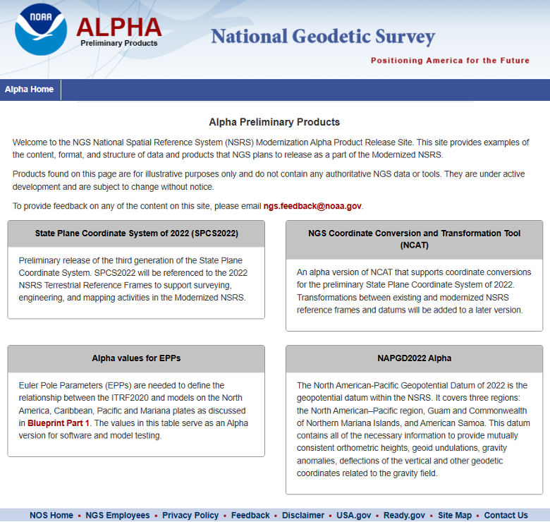
Many of you are probably aware of the actions taken by the current administration to reduce the size of the U.S. federal workforce, these actions may affect all users of U.S. geospatial products and services. NGS is not exempt from these actions; recently, they have lost many employees either though leaving service voluntarily, retiring earlier than planned, or having been terminated because they were still in the probation period of their employment. NGS leadership did not provide any details on changes in personnel; only time will tell what the loss of personnel will have with the agency in the future. That said, NGS’s plans still include transitioning the modernized NSRS Alpha Site to a Beta Site this year. The current alpha site has four products — State Plane Coordinate System. SPCS2022, NGS Coordinate Conversion and Transformation Tool (NCAT), Euler Pole Parameters (EPPs) and The North American-Pacific Geopotential Datum of 2022. My understanding is that all four of these alpha products will be transitioned to beta products sometime in 2025. Some may have limited options in the beginning.
During this period, the beta site will provide the content, format and structure of data and products that should not change much from the final product. There could be minor changes detected during the beta phase, but users should not anticipate large significant changes. That said, that is why you have a beta phase before production. It is important for users to access the beta products and identify any issues or concerns and provide feedback to NGS. Future newsletters will highlight the beta products as they are released.
NGS Alpha Site (Photo: NGS website)
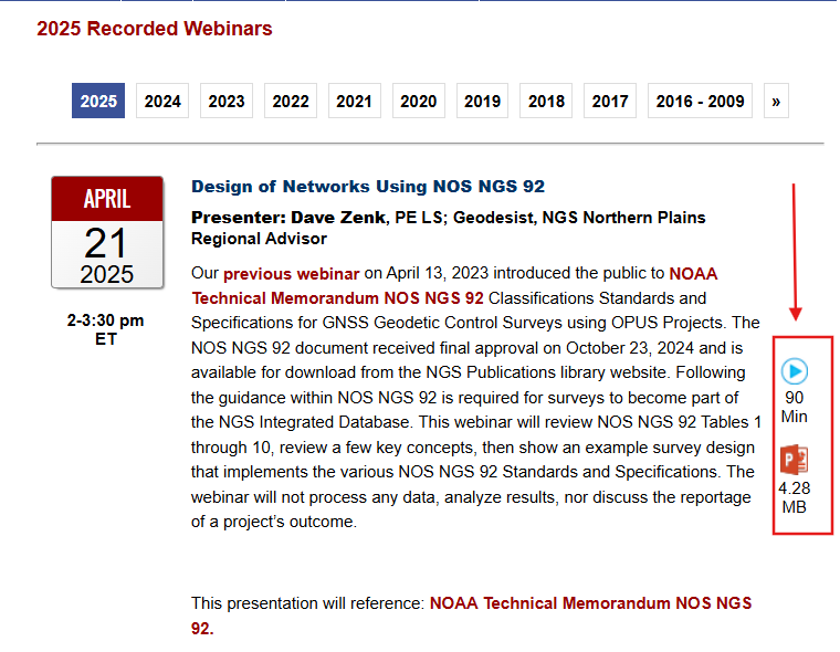
Finally, I would like to highlight a NGS webinar held on April 25, “Design of Networks Using NOS NGS 92.” Dave Zenk, NGS Northern Plains Regional Advisory, gave a good presentation outlining the tables that users need to be familiar with using OPUS Projects to process and submit GNSS projects to NGS for publications. The webinar provided a few examples to explain the concepts. Users can download the webinar from NGS webinar website.
Design of networks using NOS NGS 92. (Photo: NGS website)
I found the webinar to be very informative, and I would encourage all users of OPUS Projects to download the presentation. During the webinar, Dave briefly mentioned three items that I believe deserve more explanation for anyone using OPUS Project. I will address the following topics in more detail in future newsletters:
The mark’s classification — primary, secondary, and local – will not be included on the NGS datasheet but the local and network accuracy from the project will be provided on the datasheet. What does this mean to someone that’s using the mark in their project?
OPUS Project uses the F statistic test to determine if the appropriate constraints were imposed during the horizontally and vertically constrained adjustments. Why does OPUS Project use this statistic?
The Constraint Ratio (CR) test computed by OPUS Projects provides a way of identifying which coordinates should be constrained and which should not be considered for constraints in the final horizontally and vertically constrained adjustments. What’s the best way to use this table?
Again, I would like to invite you to check out the AAGS website and consider participating in AAGS monthly Board meetings. If you are interested in attending the meeting, send an email to me at [email protected].
Finally, users should continue to check NGS’s website for the announcement of the transition from the alpha site to the beta site. Future newsletters will highlight the beta products as they are released.
Tim Burch is a contributing editor to GPS World’s Survey Scene newsletter, authoring columns six times a year.
Burch is a professional land surveyor (PLS) licensed in Illinois and Wisconsin. He has been involved with NSPS for more than 20 years as secretary of the board of governors as well as the board of directors, NSPS vice president, a member of the Certified Survey Technician Board, Joint Government Affairs and American Land Title Association (ALTA)/NSPS Land Title Survey committees. Along with content contributor for NSPS social media, he is creator and producer of the NSPS podcast “Surveyor Says!” and a contributing writer to the NSPS newsletter “News and Views.”
Burch has been involved with the land surveying profession for more than 30 years and has represented NSPS at numerous functions and conferences. He has provided testimony on behalf of the profession at both the state and federal levels as well as helping establish a partnership with “Get Kids into Surveying.”
He is currently chair of the International Federation of Surveyors (FIG) Working Group 1.1 (Professional Ethics) and is chair-elect for FIG Commission 1 (Professional Standards).
Burch succeeded Curt Sumner, who was executive director for the past 23 years.
While not as glamorous as mild-mannered Clark Kent holding down a day job while Superman comes to the rescue in time of crisis, there are professional surveyors who work day jobs to perform our duties as practitioners to make a living and participate in association activities in their off-hours to help promote and protect their profession as well as the public they serve.
Many of the hours spent to protect the profession are in the political arena, where the battle for budget dollars and service rights are fought on nearly a daily basis. Because of the reliance of the surveyor on technological advances, the profession has been thrust into the political arena at all legislative levels. The surveyor has been tasked with leading the discussion and help the public understand why significant dollars are needed for funding many different programs to continue with our high-tech trends and lifestyles.
Three of the four presidents on Mount Rushmore started as surveyors — George Washington, Thomas Jefferson and Abraham Lincoln. (Photo: National Park Service)
The role of the surveyor has not been considered political even though several significant U.S. presidents were surveyors in their early careers. Surveyors aren’t particularly known for their public personas, much less their political prowess. Other than states that still have county surveyors, rarely do practitioners stray beyond local municipal government. One is more likely to see a professional engineer or architect as an elected official than a surveyor, but that doesn’t mean the issues we face are any less important.
My current position is a professional land surveyor with a full-time job overseeing a department in a multi-discipline office in a major metropolitan area. Besides being a contributing editor to GPS World through these articles, I also voluntarily wear many hats within our state association and the national surveying society. Several of these hats are government affairs positions at both state and federal levels, as it has become a full-time operation to keep a watchful eye at all governmental levels. From changes in regulations, budgetary revisions and threats to our professionl by outside entities, government affairs take a small army of people to keep abreast of all situations.
This month’s submission is just a snapshot of the current National Society of Professional Surveyors (NSPS) Joint Government Affairs Committee action item list being addressed and monitored through its committee members and a governmental lobbyist. The importance of this list is to give the reader a sampling of the seemingly endless battles being waged on Capitol Hill by NSPS and its members nationwide.
All these issues have GNSS at their heart and will have dire consequences if any of these subjects fall short of their intended marks.
This is not just about the GNSS and how we collect data; it’s also about the necessity of large scale data collection to provide better and safer services to the citizens of the United States and its territories.
Our current datasets and standards for data collection, like our infrastructure, is aging and lacking in detail. Serious upgrades are overdue, so several actions have been put forth to try to rectify the shortcomings.
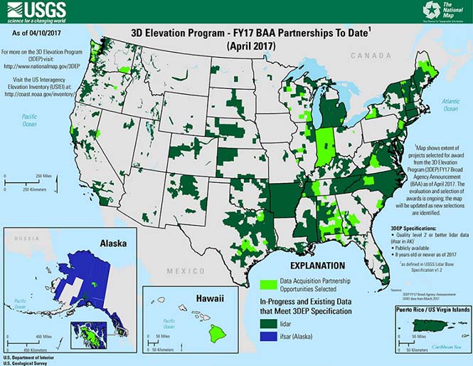
3DEP
Formally known as the 3D Elevation Program, this language was introduced as part of S. 1460 (“Energy and Natural Resources Act of 2017”) by Senator Lisa Murkowski of Alaska. This program is being created so that consistent elevation data, cultivated through many surveying and mapping sources including lidar, will be available for efficient design use throughout the American infrastructure.
While it currently does not have a single line item in any budget, the USGS Budget Summary lists its necessity in the Core Science Systems Program as part of the National Geospatial Program. This program is intended to provide high-quality topographic, geologic and hydrographic data nationwide to assist with further development of energy, transportation, drainage, emergency response and hazard mitigation.
As part of the 2019 President’s Budget, the USGS Green Book also lists having the entire nation covered by an ongoing lidar program by 2033, along with completing a significant amount of data collection by various means in Alaska by 2022, including high-resolution interferometric synthetic aperture radar (IfSAR) necessary for data collection in more difficult terrain.
The Green Book also lists high-resolution hydrographic data to support flood risk management studies, as the frequency of large scale flooding seems to be increasing substantially in more places than ever before. It also includes additional mapping data, programming and functionality for emergency personnel charged with oversight of public safety in times of crisis.
FAA reauthorization
The current FAA authorization bill expires on March 31. The biggest hang up holding up getting the bill reauthorized is privatization of the air traffic controllers, but there are rumors of tightening of UAV rules due to the rapidly growing use of the vehicles for business and personal use.
Surveyors are working with federal and state officials to help implement reasonable rules for use and coverage of the UAV as the field of surveying has been drastically affected by use of aerial vehicles. Many tasks that used to take days now take hours with increase accuracy, so the effects of the UAV will be seen for many years to come.
Digital Coast Act
One of the legislative acts that NSPS was a big part of in 2017 was Senate Bill 110, “The Digital Coast Act” which led to the introduction of the companion bill in the House as H.R. 4062. This Act will allow NOAA to perform the necessary actions to actively and effectively monitor all coasts (including the Great Lakes) by various means, including bathymetric and conventional survey methods. This will require services to be performed by public and private surveyors primarily with GNSS capability to provide NOAA with standardized information based upon established datum.
FLAIR Act
The Federal Land Asset Inventory Reform (FLAIR) Act of 2017 was introduced as House Resolution 2199 to help with creating a database of government property nationwide. The Government Accountability Office (GAO) has stated that the management of federal real property has become a “high-risk” item on its list of duties. Management of the number and value of properties has increased to a point that an overall dollar amount of federal buildings and land cannot be accurately determined.
How does the surveyor fit in with this issue? Simple. The U.S. government will need to upgrade its database of existing facilities through having them surveyed for asset management. Part of the requirements for providing these surveys will be completing the work in datums that will be following the geographical databases being designed to contain the parcel and building information. All this data will have geospatial information regarding parcel, address, utilities and functionality of the inventory, so providing the data with the sufficient attributes will become a key role for the surveyor. GNSS data collection will be at the heart of this monumental task.
Geospatial Data Act
As introduced in May 2017, the Geospatial Data Act (GDA) of 2017 is intended to jumpstart the nationwide initiative to develop and coordinate efforts to collect and maintain new datasets of elevation and infrastructure information. It is intended to improve and enhance federal geospatial activities to encourage state and local agencies to participate at the local level.
It is interesting to note, however, that the revised Geospatial Data Act was introduced by the same sponsors that did not include procurement procedures that follow the typical Brooks Act of quality-based selection, and instead relied on bid-based selection commonly found with suppliers. Both bills are being vetted by their sponsors and potential geospatial providers for clarity with ongoing debate going forward.
Hydrographic Services Improvement Act
H.R. 211 bring us the Hydrographic Services Improvement Act to provide NOAA with incentive and funding to standardize surveys desperately needed in waterway areas. Ongoing discussion continues this spring to determine sources of funding and priority of projects.
Infrastructure bill
February brought us the introduction of a significant infrastructure program aimed at improving roads, airports and bridges, with other major improvements across the country. This program is noteworthy in recognizing the need of current geospatial data and inventory of major infrastructure needs. The program sets forth the need for surveying, mapping and geospatial data for planning, design, construction, operations and maintenance for a multitude of projects nationwide. Much more will be discussed regarding the funding and priority of projects as the political year moves on.
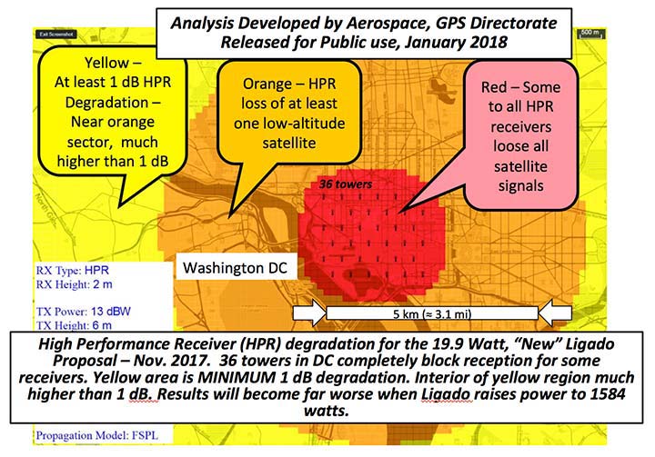
LightSquared/Ligado
Readers may remember when the original confrontation with LightSquared began in 2011, and the subsequent battle over the frequency ranges adjacent to the GPS bandwidth. The FCC gave LightSquared initial but conditional approval to move forward with terrestrial-based transmission for 4G cellular transmission for up to 40,000 land-based stations. Testing by private and governmental agencies through 2011 and 2012 proved that LightSquared would greatly harm GPS activity for both public and private use. Once exposed, the conditional FCC approval was rescinded and LightSquared retreated into the shadows…until now.
Reformed as Ligado, it has fresh investors and is making a charge into 5G technology with a revised game plan. While it is also looking to use other spectrums for communication, it once again is dangerously close to other current uses. Couple the proximity of adjacent bandwidth with the intense land-based signal versus a very weak satellite signal, there will be significant overriding by the new user. All of this is still being worked out through the FCC and the Department of Defense, so final resolution is yet to be seen.
IMAGES Act
The National Flood Insurance Program (NFIP), as part of FEMA, is looking to move forward with legislation introduced as Improvement of Mapping, Addresses, Geography, Elevations and Structures (IMAGES) Act (H.R 4905). This act intends to reform the NFIP program by utilizing new elevation data collected through the 3DEP program, which will be combined with other parcel attributes including addresses and structure types. This data will then be combined with refined floodway information to identify parcels that are more susceptible to damage caused by storms and flooding.
New legislation can be a good thing, but only if funding can be provided. This bill could provide a major upgrade to the flood mapping and insurance program, but it will hit a big snag with lack of monetary support. The proposed funding for FY2019 is $100 million, yet the project costs for the FY2018 budget is $178 million. This significant difference will make a large impact on the effectiveness of the program and proposed revamp.
Railroad reauthorization
NSPS has spent several years working with various legislators trying to find the right bill to insert language to require railroads to monument their routes before removing tracks. But with the recent accidents of various rail lines, the spotlight has been put on various factors that cause the incidents and how to eliminate their occurrence.
Positive train control (PTC) systems incorporate geospatial data collected through GNSS, lidar and conventional surveying means to work with operational systems to assess dangerous situations. Surveyors will need to be at the forefront of the necessary data collection so our efforts to continue lobbying for railroad funding will continue.
Net Neutrality Act
A political hot topic the surveyor doesn’t typically think about is net neutrality. Most people think they will be affected by lack of neutrality slowing down their home internet or streaming service, but for surveyors it will be a much bigger deal.
A remarkable number of surveyors and mappers use cellular data streaming to provide a connection to a positional correction service. The throttling of this data will effectively slow down the performance and quality of the positional data, leading to less reliability and productivity. It will also slow down the data interaction of office and field staff exchanging data and image files critical to project productivity and success.
So, when the call goes out to contact your federal representative to protect net neutrality, remember how it will affect your surveying business model and make that call.
How professional land surveying associations get it done
Many thanks to the countless hours put in by the NSPS Joint Government Affairs team, consisting of Committee Chair Pat Smith, NSPS Government Consultant John Palatiello, NSPS Federal Lobbyist John “JB” Byrd and NSPS Executive Director Curt Sumner. This group is constantly monitoring legislative action across the country as well as in D.C. and is quick to respond when action is needed on legislative issues. They do a tremendous job, yet not many see them in action. Hopefully all surveyors will continue to see and feel the benefits of their results.
As simple as the process is, the political world has gotten much more complicated as time marches on. From local municipal offices to Washington, D.C., getting things done through legislation has become a long process that takes patience and plenty of money to get your voice heard. Surveyors are no different than any other profession in that we must stay out in front of issues that affect our physical and business world. The important part is to stay informed and have a voice.
Let’s also remember those three fine individuals, memorialized on Mount Rushmore, who accomplished great things after their stints as surveyors, so anything is possible if we keep our voice in government.
Surveying has evolved into a highly technical professional with GNSS as a backbone method of data collection. With the U.S. government at the center of that technology, we need to make sure we, as the surveying practitioner, stays engaged.
Jim Williams, manager for the Federal Aviation Administration’s Unmanned Aircraft Systems (UAS) office, will be the keynote speaker at the MAPPS National Surveying, Mapping and Geospatial Conference, scheduled for April 13-16 in Crystal City (Arlington),Va.
Williams will speak at a luncheon on April 14. He’ll address the recently published notice of proposed rulemaking issued by his office in FAA, including regulations and policies that will affect surveying and mapping firms that want to fly unmanned aerial vehicles (UAV) and UAS in the commercial market.
“MAPPS has worked with Mr. Williams and his staff for several years to assure that business and societal benefits of using UAV/UAS for aerial surveying, mapping and imagery are recognized and empowered in FAA policy,” said John Palatiello, MAPPS executive director. “UAV/UAS technology is the future of the mapping, surveying and geospatial profession. It is imperative that geospatial firms have the ability to operate UAV/UAS. Mr. Williams understands this, and his office’s policies have reflected his understanding of our community as an important stakeholder.”
“We’re honored to have Mr. Williams join us at the conference. We look forward to hearing how he sees the future of UAV/UAS and how it will effect the business and professional practice of surveying and mapping,” said Curtis Sumner, National Society of Professional Surveyors (NSPS) executive director. “His addition to the conference strengthens an already outstanding program.”
Full registration for the conference is required for admission to the keynote luncheon.
“These sessions will provide attendees and members perspectives on some of the major issues facing the profession,” said John Palatiello, MAPPS executive director, and Curtis Sumner, NSPS executive director. “Our goal from the beginning was to provide conference sessions that are distinct from what surveyors experience at their state conferences. These presentations will give conference attendees and members new insights on the geospatial profession, particularly in the commercial market.”
The speakers for Monday, April 13, are listed below, along with the session name.
Michael Anderson, POB magazine, “POB Top 100″
Bryan Baker, Leica, “What You Need to Know Before Starting Up Your Unmanned Aircraft System (UAS) Department”
Pam Nobles, Rob Garster, “What Is Surveying? A Discussion of Infringing Technologies”
The speakers for Wednesday, April 15, are listed below, along with the session name.
Rhonda Rushing and a panel from Berntsen Inc., “Smart Markers for the Nation’s Land & Infrastructure Assets”
Ted Naak, Certainty 3D, “Establishing Requirements, Extracting Metrics and Evaluating Quality of LiDAR Data”
Neil Sandler and a panel from xyHT magazine, “Are You Prepared for Change?”
The overall conference will serve as an umbrella to include plenary sessions, an exhibit hall, and social and networking activities designed to create synergy among the many vertical segments. It will also feature a “conference within a conference” format, in which participating organizations will hold their own meetings and sessions.
MAPPS will host its annual Federal Programs Conference April 14-15. Presentations by federal agencies, the Obama Administration and members of Congress will include briefings on programs, budgets and requirements for the acquisition of geospatial services, data and products by contract from the private sector.
NSPS will host the finals of its annual Student Competition on April 13. The 2014-15 competition will, for the first time, include not only student teams from four-year degree programs, but also teams from two-year degree programs. The NSPS annual General Membership meeting and other business meetings will be scheduled throughout the week in order to allow NSPS leadership to more fully participate in conference activities.
MAPPS and NSPS members will visit some 200 Congressmen and Senators at the U.S. Capitol, advancing a common agenda of legislative issues that serve the public and engage the surveying and mapping community.
Also on the program will be an invitation-only USGS 3DEP stakeholders meeting, a summit by the National Geodetic Survey (NGS) of the National Oceanic and Atmospheric Administration (NOAA) and a licensed geospatial data forum by the Geospatial Management Office (GMO) of the Department of Homeland Security (DHS).
POB (Point of Beginning) magazine is conducting a surveying and mapping market study that will rank the top 100 companies based on total geospatial revenue for 2014.
Rankings will be based on total revenue from surveying, aerial mapping, geospatial imagery, 3D modeling, BIM, GIS/IT, underground mapping and other geospatial services.
“Collaboration is key to success in the geospatial community,” said John Palatiello, MAPPS executive director. “We’re pleased POB has chosen this forum to help launch this important project.”
Collaboration: The Map of the Future will bring together associations, professional societies, companies and government agencies in the surveying, mapping and geospatial fields. The event hopes to bridge gaps between government agencies and the private sector, as well as explore different disciplines in the community. It also will prove a forum for discussions on best practices, technology, issues and policies.
The conference features a “conference within a conference” format, in which participating organizations will hold respective meetings and sessions.
“Surveyors have long relied on POB as a major source of news and information about the profession and its market study and Top 100 listing will be a significant contribution,” said Curtis W. Sumner, LS, executive director of NSPS.