NV5, a division of Acuren Corporation, has become the first geospatial company to acquire and deploy Hexagon’s Leica CoastalMapper, an airborne bathymetric lidar system for coastal and riverine mapping.
The CoastalMapper, developed by Leica Geosystems, combines a bathymetric lidar module with topographic lidar and an imaging sensor in a compact pod. The system collects bathymetric and topographic lidar data simultaneously with high-resolution imagery during a single flight. It captures up to 1 million bathymetric points per second and 2 million topographic points per second, producing imagery at a 5-centimeter ground sampling distance at standard flying altitudes.
The system can operate at higher altitudes than previous generation systems, enabling surveys of steep mountainous river terrain. Applications include infrastructure resilience, flood monitoring and environmental investigations in shallow and deep waters.
Kurt Allen, president of NV5’s Geospatial Business Unit, said the sensor system will allow the company to deliver more comprehensive datasets in coastal and riverine environments and support environmental resilience and infrastructure planning.
NV5 Geospatial will receive the Leica CoastalMapper from Hexagon by the end of the year, with a handoff that took place at Intergeo in Frankfurt, Germany, Oct. 7-9, 2025.
NV5 is celebrating two decades of delivering critical geospatial services to the National Oceanic and Atmospheric Administration (NOAA).
For the past 20 years, NV5 has completed more than 220 contracts across 30 states, covering more than 50,000 square miles. These projects involve topobathymetric surface modeling of shorelines, bays, estuaries, lakes, wetlands, rivers and streams to provide detailed data for various applications. The information generated helps NOAA protect and restore natural resources and habitats, update nautical charts and understand the effects of environmental and human-induced changes over time.
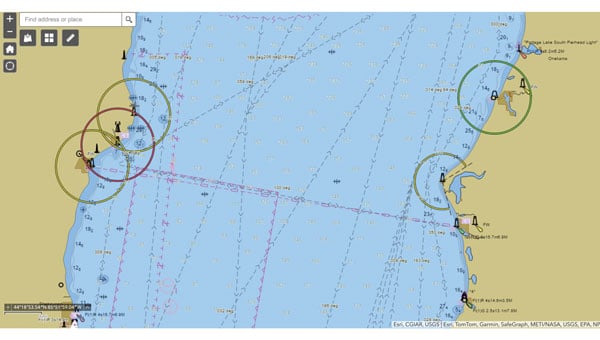
A screenshot from the NOAA ENC Viewer of the updated nautical chart of southern Lake Michigan, created using multibeam bathymetry and backscatter data. (Photo: NOAA)
The company employs airborne remote sensing technologies, such as topobathymetric laser scanning, to capture near real-time changes in nearshore topography and bathymetry. Additionally, NV5 integrates marine vessel-based technologies, such as multibeam echo sounding, to map offshore bathymetry, including sand resources, essential fish habitats and historic shipwrecks.
“Our collaborations with NOAA over the past 20 years have yielded many important insights and baseline data that helps the agency with its core mission of climate monitoring, coastal restoration and supporting marine commerce – all of which supports our nation’s economic vitality and affects more than one-third of America’s gross domestic product,” Dave Bernstein, vice president of hydrospatial operations at NV5, said.
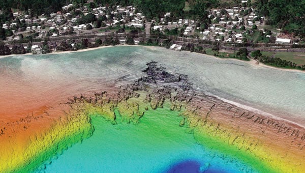
The National Geodetic Survey Remote Sensing Division’s Coastal Mapping Program requires the collection of airborne topographic/bathymetric lidar and digital camera imagery data to enable accurate and consistent measurement of the national shoreline following Hurricane Sandy’s landfall. (Photo: NV5)
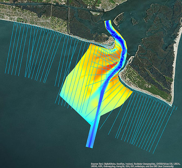
In one notable project, NV5 conducted a large-scale hydrographic survey in southern Lake Michigan for NOAA’s Office of Coast Survey. The survey covered 481 square nautical miles from northeast Chicago to Michigan City, Indiana — an area that had not been surveyed since the late 1940s. Using multibeam bathymetry and backscatter data, NV5 updated NOAA nautical charting products to improve maritime safety along the Michigan, Indiana and Illinois shorelines. Under NOAA’s Office for Coastal Management contract, NV5 also provided certified hydrographer expertise aboard the Pisces (R226), a NOAA fisheries research vessel. These efforts included overseeing the collection and processing of hydrographic data for marine habitat mapping.
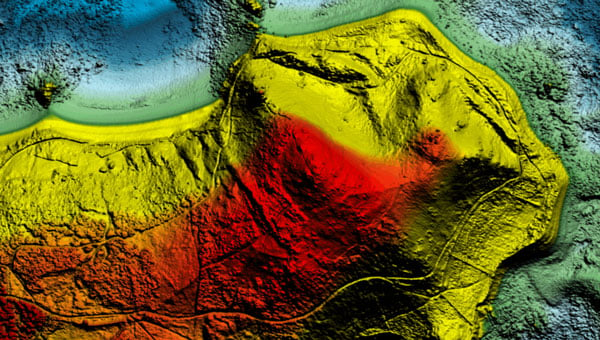
A view looking south at the Submarine Canyon on Asan Point, Guam. The image was created from the lidar bare earth model and lidar point cloud colored by elevation and RGB values from imagery respectively. (Photo: Partnership between NV5 and Woolpert)
NV5 has also contributed to NOAA’s Coastal Change Analysis Program through projects that utilized aerial multispectral imagery and machine learning techniques. In Rhode Island, NV5 partnered with the National Estuarine Research Reserve System to study salt marsh habitats and produce change mapping products.
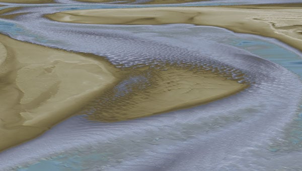
A view looking northeast from Virginia Key shows the topobathymetric surface of the intertidal zone near Fisher Island, Florida. (Photo: Nicholas Klein / iStock / Getty Images Plus / Getty Images)
Similarly, high-resolution land cover products were created for Brown County, Wisconsin, and key watersheds to assess urban growth, map wetlands, delineate wildlife habitats and monitor land cover changes over time. Other initiatives include mapping eelgrass habitats along coastal Massachusetts using multispectral aerial imagery and analyzing satellite imagery for wetland changes in the Great Lakes region.
Through these diverse projects, NV5 continues to provide NOAA with essential geospatial data that supports its mission of environmental stewardship and maritime safety while contributing to national economic vitality.
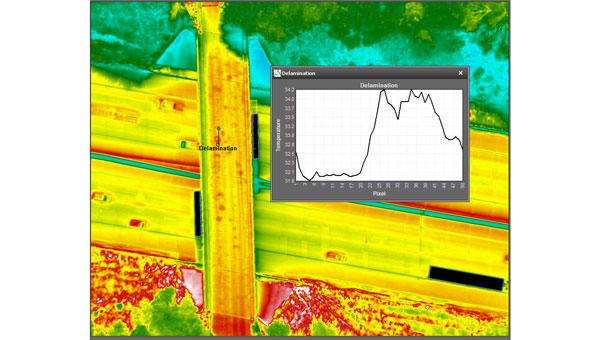
NV5 Geospatial’s thermal infrared (TIR) solutions for transportation infrastructure challenges are now being used in transportation projects to analyze concrete bridges in the Midwest.
This remote sensing technology offering enables local and regional transportation agencies to identify structural problems well before they reach the surface of concrete bridge decks.
Concrete bridge decks require periodic inspections for continuous maintenance, rehabilitation, and replacement work. TIR is used in non-destructive inspection techniques for analyzing concrete bridge decks and identifying potential delamination. This process is made more efficient with aerial collection.
The company recently conducted two separate pilot projects with two Midwestern states’ departments of transportation using aerial data collection to identify thermal anomalies of potential delamination for 200 bridge concrete surfaces. Both projects were completed by flying a fixed-wing aircraft at a low elevation with the thermal sensor mounted to its floor. The flights were conducted without ground-based support.
NV5 Geospatial’s project design focuses on optimal timing and resolution to maximize thermal contrast, which ensures accurate detection of features or patterns of interest. The acquired thermal imagery is orthorectified to create a seamless mosaic for each bridge. TIR imagery can be co-acquired with other airborne technologies, such as true color imagery and lidar, to provide supplementary information.
The TIR aerial solution allows users to capture up to 100 bridges in a single day and offers a detailed and short turnaround of data analysis. It identifies potential issues before ground truthing is required and supports state-wide inspection prioritizations.
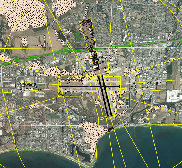
NV5 Geospatial, a large geospatial data company, provides services for airport projects across the United States and U.S. territories — mainly supporting airport planning and engineering firms that must meet FAA survey and mapping requirements for data collection at airports. “We generally are a sub-consultant to them, helping them achieve those survey standards for collecting the data and submitting it to the FAA,” said David Grigg, the company’s Aviation Program Director. Typically, this is around planning projects such as airport layout plans and master plans, but also engineering projects such as runway extensions and runway reconstructions.
As an example, Grigg cited the extension of a runway, which requires new flight procedures to be established. “Two survey missions are required for runway extensions. The primary mission is to establish control for the aerial imagery. Using the imagery, control and design data, we check for obstacles photogrammetrically. That data is sent to the FAA and procedures are developed. After construction is complete, we go back to the airport to survey the changed runway and navigational aids (NAVAIDS) to verify that what was designed was ultimately built.”
Another way in which NV5 Geospatial supports airport clients is by conducting obstruction studies around them for vegetation management. “That’s generally where we pull in the lidar surveys,” said Grigg. The FAA’s standards for relative and absolute positioning accuracy for trees are “rather generous” by surveying standards, he said. “We’re talking two to three feet vertically and twenty feet horizontally. It’s not like a typical mapping job where you’re guaranteeing it to one foot or better horizontally and half foot or better vertically.”
The FAA, he points out, has published guidance on how lidar may be used. “We mostly use aerial photogrammetry to support projects in the FAA’s airports GIS program. When we collect lidar at an airport, we do it to generate contours and to identify individual tree canopies. Our lidar-derived data is most often developed to benefit airports for tree mitigation not for FAA airports GIS survey projects.”
Image: NV5 Geospatial
On the other hand, the FAA has strict requirements regarding metadata to document when, where, and how each control point is collected. “At the time of the survey, photographs are taken of the GPS units from different angles and cardinal directions,” Grigg said. “This is visual documentation for NGS that the surveyed point is at the location described. ”
Another challenge for surveyors working at airports is that they are required to pull back for incoming aircraft. “Obviously, you will have some logistical issues at busy airports,” said Grigg. Surveyors are required to have special lights and markings on any vehicles that enter the airport property to ensure ground and air visibility. Aircraft movement also impacts surveyors as they must move away from the runway safety area (RSA) for take-offs and landings. Busier airports are surveyed at night, when air traffic is reduced or runways are closed.
Image: NV5 Geospatial
A typical project for a small airport takes about nine months, while for bigger airports — such as Chicago O’Hare, Dallas-Fort Worth, or Hartsfield-Jackson Atlanta — they can take up to twice as long. “The large hubs update their master plan on a more reoccurring basis, such as every three to five years,” said Doug Fuller, NV5 Geospatial’s Airport Solutions Specialist. “As the airports get smaller, you start stretching out that timeframe.”
Airport survey requirements
[The following was written by NV5 Geospatial and only lightly edited by GPS World.]
Airports have surveys conducted for many different reasons. However, all survey types require the collection, classification and reporting of accurate data about the project. The methodology selected to gather the information is up to the professional surveyor’s judgment. Some features require observation through ground field methods, while others lend themselves to collection via remote sensing technologies.
All surveys start with a search for existing airport control, which are called Primary Airport Control Points (PACS) and Secondary Airport Control Points (SACS). These are points on the airport that have been adjusted by the National Geodetic Survey (NGS). This ensures that the survey is done on the National Spatial Reference System (NSRS).
A typical survey includes surveying the runway, the end points, any displaced thresholds, and a profile along the centerline of the runway. If the centerline marker is not in the correct location or if it is not there at all, the surveyor will make the necessary measurements to establish the proper location and set a new marker. Next the surveyor must locate all NAVAIDS and survey them at the proper location as described in FAA Advisory Circular 150/5300-18B.
After the NAVAIDS are located, the photo control survey will be done. This still requires the PACS and SACS to be the points of origin of the survey. The base requirement as described in FAA Advisory Circular 150/5300-16C is to survey ten photo control points and five check points. The check points are sent to NGS’s Online Positioning User Service (OPUS). This is used to check that the survey was done on the NSRS and that the compilation meets FAA standards.
The standards the surveyor must meet vary depending on the equipment type or photo control point. Examples of the accuracy requirements for the NAVAIDS are as follows:
Point
Horizontal
Vertical
Distance measuring equipment
+/- 1 ft
+/- 1 ft
Glideslope
+/- 1 ft
+/- 0.25 ft
Inner marker
+/- 10 ft
+/- 20 ft
Localizer
+/- 1 ft
+/- 0.25 ft
Runway end point
+/- 1 f ft
+/- 0.25 ft
Runway profile points
+/- 1 f ft
+/- 0.25 ft
Photo control
+/- 1 ft
+/- 1 ft
PACS and SACS
X
Y
Z
Ellip.
Inverse from PACS to SACS
surveyed relative to published
0.09 ft
0.09 ft
0.15 ft
0.13 ft
When surveying on airport property, the largest challenge is always accessing the runway safety area to locate the runway ends and profiles. At small airports Surveyors must work when the runway is not busy; at airports with FAA control towers when the runway is closed. Frequently this is done overnight. Other challenges include access to the FAA NAVAIDS. Some of them must be turned off to be surveyed and others require survey points on which it is not possible to set an instrument. When we are not able to occupy a point, we collect it by surveying multiple equidistant locations around the NAVAID and averaging them.
Image: NV5 Geospatial
NV5 Geospatial surveyors use a combination of real-time (R/T) and post-processing techniques. We also use OPUS with the PACS and SACS and the five check points. Once the PACS and SACS have been determined to be stable, the proper coordinates are applied to them and the R/T points are adjusted using Trimble Business Center (TBC). NV5 Geospatial uses Trimble TRM-R8s and we recently added TRM-R12i receivers to our equipment. We use ground control points to orient the photography and to calibrate the lidar.
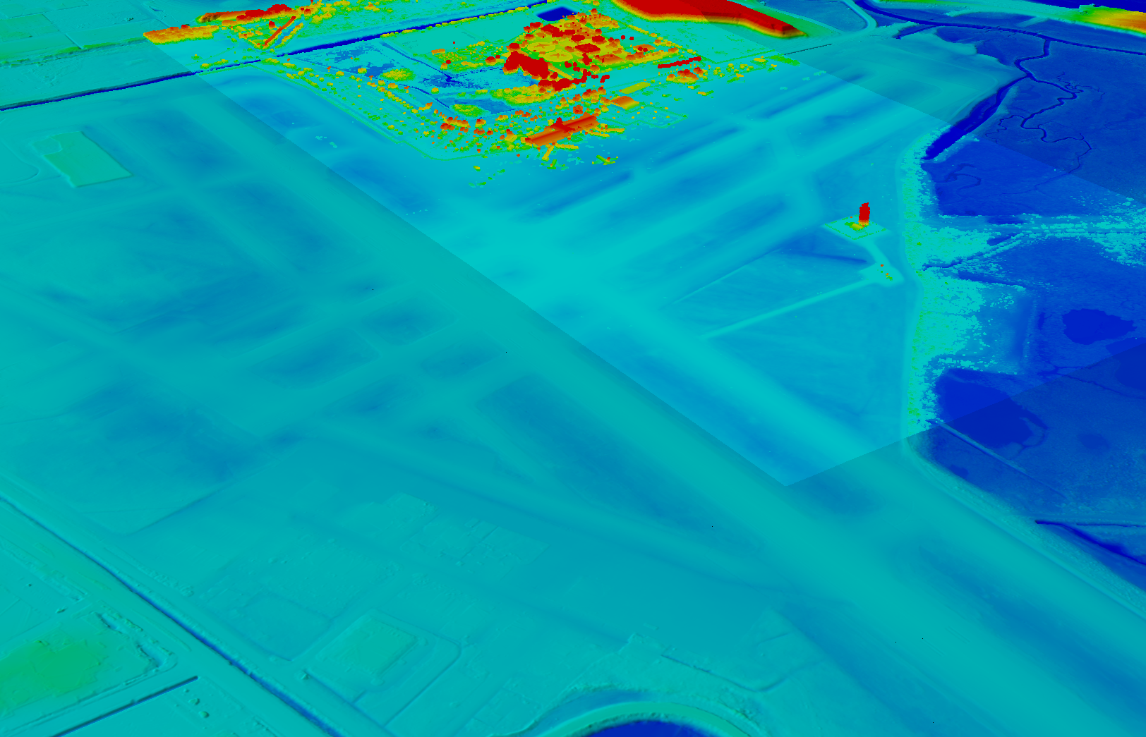
NV5 Geospatial has mapped more than 26 million acres of North America’s shoreline and riverine environments across more than 200 projects.
The projects have spanned from the Nuyakuk River in Alaska, Lake Tahoe in California, the Rio Grande in Texas, the entire coasts of South and North Carolina, the Achigan River in Quebec, Chesapeake Bay in Maryland and the Florida Keys.
In 2022, the company mapped and acquired topobathymetric lidar data for 14 projects including the Yellowstone River, Wyoming; Hells Canyon, Indiana; Revillagigedo Island, Alaska and Iles de la Madeleine in Quebec.
NV5 Geospatial first mapped these environments in 2012 using high-resolution bathymetric lidar and natural color imagery. The company mapped 34,051 acres of shoreline along the Sandy River, located in northwestern Oregon, to study the ever-changing basin geomorphology.
NV5 has also signed a two-year contract with the National Geodetic Survey of the National Oceanic and Atmospheric Administration to provide topobathymetric lidar, 4-band imagery and mapping of 3,115 sq miles of the Maine shoreline.
“For a decade we have been helping local, state, and federal government agencies as well as commercial and private entities gain the insights they need to solve some of their most challenging nearshore and riverine projects through our mapping technologies including topobathymetric lidar,” Kurt Allen, vice president of NV5 Geospatial, said. “Whether it be mapping the shoreline after a hurricane, updating the national shoreline, assisting water boards with flood planning, or hundreds of other possible use cases, we are constantly improving our technology and scalability to always be at the ready for our customers.”
NV5 Geospatial has forged a contract with the Caribbean Community Climate Change Center (CCCCC) to conduct aerial lidar and orthoimagery surveys across the Caribbean. The pilot project will provide advanced geospatial data to help the island nations understand natural and man-induced climate changes, develop programs to support resilience and sustainable development, and establish a foundation for future work.
NV5 Geospatial will conduct topographic and topobathymetric lidar surveys, as well as orthoimagery, via a fixed-wing aircraft. Data collected will help CCCCC address the impact of climate variability and identify potentially hazardous impacts.
The project will cover 10 sites spread across more than 3,000 km. The sites include areas in Suriname, Guyana, Tobago, Barbados, St. Vincent and the Grenadines, Saint Lucia, Antigua and Barbuda, St. Kitts and Nevis, Turks & Caicos and Belize.
Other logistical considerations include the combination of microclimates inherent around tropical islands, highly variable weather conditions, cloud formations and jungles, some of which are in high relief areas or covering the entire area.
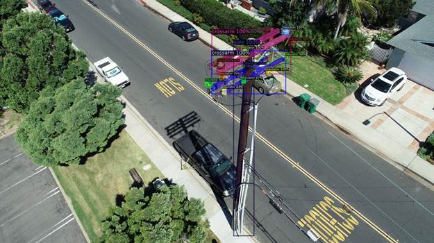
NV5 Geospatial’s distribution network data shows pole usage. (Image: Nv5 Geospatial)
Asset and vegetation management applications help utilities minimize risk and improve the reliability of electric distribution networks
Geospatial data firm NV5 Geospatial is applying remote-sensing data analysis to improve the way utilities manage their distribution networks. The company mapped more than 5.5 million miles of utility distribution networks in the United States using a combination of lidar and orthoimagery sensors on mobile and airborne platforms to acquire data for both asset and vegetation management.
Analysis of this geospatial data enables electric utilities to minimize risk and maximize reliability, while increasing efficiency.
“An aging grid, workforce shortages, increasing energy demands and an uptick in major weather events are combining to create a perfect storm that could impact reliability, customer service and safety for electric utilities across the country,” said Eric Merten, vice president, Commercial Group at NV5 Geospatial. “A boots-on-the-ground approach to management cannot keep up with demands related to aging equipment, compliance, pole loading and vegetation encroaching on infrastructure.
“NV5 Geospatial’s innovative remote-sensing applications and data analysis tools give utilities the power to proactively address problems in their distribution network before they impact operations or customers,” Merten said.
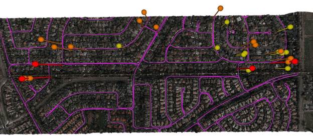
A distribution network (purple) and vegetation risks (red/yellow pins). (Image: NV5 Geospatial)
Built on the success of its remote-sensing applications for utility transmission networks, NV5 Geospatial’s distribution management solutions offer end-to-end capabilities — from acquiring accurate, high-quality geospatial data to data analysis and visualization using custom viewers and enterprise geospatial information systems (GIS) — and can be customized to meet the use cases and budgets of utility companies.
Using NV5 Geospatial’s tools, distribution network asset managers can achieve compliance with National Electrical Safety Code (NESC) clearance guidelines, and get clear visibility into joint use of poles to prevent pirating.
The NV5 Geospatial remote-sensing data also can help quantify vegetation with distribution rights-of-way and determine risk based on proximity to wires and poles.
Work supports climate change research, the 2020 Juneau landslide, and effects of the Exxon-Valdez oil spill
NV5 Geospatial marks its 65th year helping Alaska solve environmental and geospatial challenges, with new hydrospatial projects with the National Oceanic and Atmospheric Administration (NOAA), U.S. Geological Survey (USGS), Alaska Railroad Corporation, Alaska Department of Natural Resources, U.S. Fish and Wildlife Service and the U.S. Department of Agriculture.
“As climate change intensifies, so do the challenges that Alaska and its citizens face,” said Adam McCullough, NV5 Geospatial’s Alaska program manager. “From mapping the coastlines, to collecting lidar and imagery data to better understand geohazards and landslide risks, to mapping rivers, lakes and other surface water features, we are involved in critical projects across the state. We are proud to work side by side with national, state and local governments and agencies, as well as private corporations to facilitate climate-change informed decision making over the state’s valuable, unique resources.”
The following six projects provide a sampling of the work in which NV5 Geospatial has participated across the state:
Revillagigedo Topobathymetric Lidar and Imagery Mapping – NV5 Geospatial is working alongside state and federal partners on a multi-year program to map Alaska’s 66,000 miles of complex coastline. This work is part of a larger national shoreline mapping project being undertaken by NOAA to gather baseline data to update nautical charts, manage coastal resources, and define U.S. territorial limits.
The data collected also can support maritime trade and transportation, as well as wave and wind energy site selection. The data supports coastal resiliency efforts that include modeling sea-level change, storm surge, coastal flooding and pollution trajectories, as well as analysis and monitoring of critical habitats, developing land and marine GIS base layers.
The Alaska Railroad Corporation (AARC) Lidar Acquisition for Geohazards – AARC engaged Michael Baker and NV5 Geospatial to collect high-resolution topographic lidar and imagery data for analysis of geohazards, hydrology, engineering and landscape ecology across portions of its vast rail network in Alaska. NV5 leveraged its advanced combined low-altitude sensor solution (CLASS) mounted to a helicopter to simultaneously collect lidar, ortho-imagery and oblique images along the rail line that enables researchers to evaluate landslide and hydrological risks in areas of concern.
USGS 3DEP Juneau Landslide Lidar Study – In the aftermath of unprecedented rain events in Southeast Alaska in December 2020, the City and Borough of Juneau, along with Alaska Electrical Light & Power, partnered with the USGS to acquire and process 3DEP-compliant airborne topographic lidar data covering the Juneau landslide impact area. The USGS contracted NV5 Geospatial to perform the lidar survey that included acquiring extremely accurate lidar to USGS’s highest quality level specification.
The lidar data will support planning and landslide assessment to enable the reinforcement of critical infrastructure resources in the area. Project stakeholders are able to use this data along with existing lidar collected by NV5 Geospatial in 2013 to study how the landscape is changing in precise detail.
Alaska 3D Hydrography Program (3DHP) – The USGS, in partnership with state, local, and tribal governments and others, has embarked on a multi-year effort to enhance the mapping of rivers, lakes and other surface water features for the entire state of Alaska. Supporting that initiative, NV5 Geospatial has been repeatedly contracted by USGS to develop improved hydrography, covering 62,934 square miles to date.
NV5 Geospatial is leveraging the recently completed statewide interferometric synthetic aperture radar (IfSAR) coverage as the elevation data source to define drainages, impoundments and other hydrographic features in greater detail and accuracy. Once completed, the enhanced map data will be used to inform navigable waterways; conduct flood analysis; and delineate wetlands, fish habitat, recreational opportunities, coastal resiliency and more.
Exxon-Valdez Oil Spill, National Wetlands Inventory and National Hydrography Dataset – The U.S. Fish and Wildlife Service is leveraging grant funds to map wetlands and hydrography for areas affected by the 1989 Exxon Valdez oil spill. These areas include Kodiak Island, Afognak Island and the shorelines of Shelikof Strait in Alaska. Wetlands data are used by natural resource managers to promote the understanding, conservation and restoration of wetlands, while the hydrographic data supports scientific studies, cartography and natural-resource management associated with inland surface water features.
U.S. Department of Agriculture Aerial Orthoimagery Term Contract – NV5 Geospatial was awarded a large multi-year term contract to support aerial orthoimagery in Alaska. The contract has been used to acquire tens of thousands of square miles of high-resolution orthoimagery covering some of the nation’s largest national forests including Tongass and Chugach, as well as agricultural lands significant to the Natural Resource Conservation Service. These areas are in areas with some of the most challenging weather and terrain anywhere in North America and require aircraft on persistent standby to take advantage of the brief windows of opportunity to collect high-quality imagery.
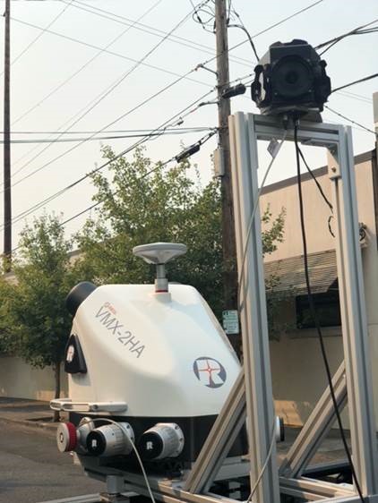
NV5 Geospatial has acquired the new Riegl VMX-2HA dual-scanner mobile mapping system. The system will initially deploy in utility and transportation projects and enable NV5 Geospatial to collect highly accurate, feature-rich data at highway speeds.
The flexibility, ease of setup, and smaller footprint will also allow the use of the VMX-2HA on various platforms, including boats, all-terrain vehicles and trains.
The VMX-2HA delivers mobile point clouds at a resolution of 1,000 to 4,000 points per square meter (pops) and 0.08-foot vertical accuracy in terms of 95% confidence intervals. It also features a high-speed 10 GigE link, which supports reliable data acquisition of up to 2 million measurements per second and image data from all integrated cameras.
NV5 Geospatial will launch the VMX-2HA as part of a mapping project for a large U.S. utility company and implement it for work being done for the U.S. Department of Transportation.
NV5 Geospatial has launched Trim Optimization, a predictive modeling platform that enables electric utilities to enhance vegetation management programs with risk-based assessments.
Using information from existing lidar and historical data, utilities can leverage Trim Optimization to prioritize tree-trimming activities by taking into account the risk posed by individual trees and other operational constraints.
“Trees are to blame for a large percentage of outages, and vegetation management is the single biggest cost for electric utilities. Yet, utilities have only started to look at proactive, risk-based management programs, rather than the traditional cycle-based ones,” said Ian Berdie, vice president of innovation for NV5 Geospatial. “NV5 Geospatial’s Trim Optimization platform will help utilities improve grid reliability through better decision making, while also saving them money through greater efficiency and the ability to target areas that have the most potential for problems.”
Vegetation is one of the largest sources of outages, accounting for more than half, according to a recent survey, “Geospatial Analytics, Resilience and Extreme Weather Readiness.” The majority of respondents also noted that they use data to analyze risk, but budget constraints often prevent them from investing in the data they need.
The trim optimization platform takes a phased approach to identify relative risk to target vegetation management work where it will have the most impact. With extensive expertise, NV5 Geospatial first identifies several attributes associated with vegetation-caused outages that can be modeled from high-density lidar and provide a relative risk score.
Utility-specific data, such as historic tree failures information or other factors, can be analyzed to enhance results further.
The final risk scores will provide a quantitative assessment of combined risk, enabling utilities to develop work plans that prioritize vegetation management mitigation efforts and result in greater operational efficiency.
NV5 is holding a webinar on Trim Optimization on Aug. 25. Register here.
Women make up more than half of NV5 Geospatial’s eGIS business unit, which collects and analyzes data to develop custom applications for government clients.
Women make up more than half of the company’s team. From left are Alexa Ramirez, Nicole Wigston, Danielle Comely and Cherie Jarvis. (Image: NV5 Geospatial)
Even though women make up nearly half of the workforce, they are still highly underrepresented in the science, technology, engineer and math (STEM) field. In fact, the U.S. Census Bureau reports that while women have made gains since the 1970s, they still only account for about 27% of STEM workers.
But one company bucking this trend is NV5 Geospatial, which was formed with the 2019 merger of global engineering firm, NV5 Global, and Quantum Spatial Inc., North America’s largest geospatial data firm. Quantum Spatial brought with it a long history of providing innovative remote sensing, acquisitions and analytics solutions that answer some of the toughest questions and deliver unique insights. It has become the go-to provider of geospatial services for a wide range of clients, including major government agencies, the military, utility companies, engineering and construction firms, and corporate organizations. These clients value the organization’s proprietary and ground-breaking approach of using geospatial information to plan, manage resources, mitigate risk and contribute to scientific understanding.
Women make up more than half of NV5 Geospatial’s enterprise GIS (eGIS) business unit, which is responsible for collecting and analyzing data to develop custom applications for key government clients.
In 2020, the company named Cherie Jarvis as director of the eGIS team, which has grown to include three female project managers and four analysts that bring diverse backgrounds – from marine biology and zoology to environmental science to geology – to their work.
“Seeing so many women in GIS is not unusual for me because I think strong women attract other strong women,” Jarvis said. “The women on our team are not only experts in their field, but they are very detail oriented and have the technical, organizational and people skills to adeptly handle all the variables that come with the complex eGIS projects we manage.”
Jarvis, a PMP, Scrum Master and Certified Scrum Product Owner, has led several award-winning projects, including a decision support tool to guide environmentally sound dredging of offshore sand shoals for the Bureau of Ocean Energy Management (BOEM) and the National Oceanic and Atmospheric Administration (NOAA), and a portal to access navigation-related data and tools for sediment and ecosystem management for the U.S. Army Corps of Engineers (USACE).
Others on the team include:
Alexa Ramirez, senior project manager, PMP, GISP is a 13-year veteran of NV5 and its predecessor companies, where she previously specialized in lidar processing. She transitioned to the GIS team to create the data model for the BOEM Marine Minerals Information System (MMIS).
Danielle Comely, senior project manager, PMP, CSPO is an environmental scientist who recently joined NV5 from NOAA to work on BOEM, USACE and Southwest Florida Water Management District (SWFWMD) projects.
Ashley Reade, GIS analyst and one of the newest in the eGIS group, moved from the NV5 acquisition team to help manage MMIS and leverage her marine biology background to help assess fish habitat during dredging as part of the USACE South Atlantic Regional Biological Opinion (SARBO).
Liz Rodgers, senior GIS analyst, leveraged her degree in zoology to help build an environmental sensitivity index tool for NOAA and has been supporting work on USACE SARBO.
Emily Sandrowicz, GIS analyst, joined to work on MMIS, but moved to the geoESPIS (Environmental Studies Program Information System) project. She’s now pursuing her Master’s degree in GIS.
Maggie Satterfield, senior GIS analyst, brings a background in forestry to her work on the Bureau of Land Management (BLM) National Cultural Resources Information Management System (NCRIMS).
Nicole Wigston, senior project manager, PMP, CSM, brings a strong geography and technology background having previously worked for ESRI. She manages national data standardization projects for BLM and on projects automating NV5G internal data pipelines.
Multi-beam bathymetry and topo/bathy beach profiles of the Cape Fear River Inlet (USACE Wilmington). (Image: NV5 Geospatial)
Following its March 29 acquisition of Geodynamics LLC, NV5 Geospatial has built a comprehensive suite of solutions for geospatial surveys of deep-water and near-shore environments. Geodynamics will operate as a wholly owned subsidiary of NV5 Global as part of the NV5 Geospatial group.
The acquisition brought together complementary, advanced technologies — Geodynamics’ full ocean-depth sonar-based hydrographic and geophysical surveying with NV5 Geospatial’s topographic and bathymetric capabilities. Together, the technologies deliver detailed insights for a variety of applications, including coastal management, flood monitoring, ecosystem protection, research and more.
“This acquisition was a natural evolution toward our common goal of delivering valuable geospatial insights to our clients,” said Kurt Allen, vice president, Federal Vertical for NV5 Geospatial, powered by Quantum Spatial. “Our decades’ of combined experience and expertise using the most sophisticated technology for data acquisition and analysis will enable us to meet the most demanding client requirements.”
Geodynamics is a pioneer in collecting and processing single-beam, multi-beam, sidescan, geophysical and acoustic backscatter hydrographic data in some of the most challenging coastal environments, including dynamic tidal inlets, high-energy surf zones, and rapidly changing shoal systems that challenge navigation.
Geodynamics has completed large-scale hydrographic survey projects in the coastal and adjacent ocean areas of the entire United States, including detailed hydrographic surveys to support federal nautical chart updates in the Atlantic, Gulf of Mexico and Great Lakes region for the Office of Coast Survey of the National Oceanic and Atmospheric Administration (NOAA).
With a research focus on coastal geology, Geodynamics’ offshore geophysical surveys have supported mapping of marine minerals, benthic habitat and identification of potential submerged archaeological resources.
The relationship between the companies began with a joint venture in 2019. Working collaboratively as MarineGeoSpatial LLC, the partnership provided aerial- and ship-based remote sensing for offshore/marine survey and data collection, mapping and data analysis, and marine enterprise GIS services.
“We are excited to embark on this new chapter with NV5,” said Geodynamics CEO Sloan Freeman, PLS. “It is the perfect strategic alignment of aerial, subsea survey and geospatial services. Together, we have the technology, tools and experience to provide the best solutions to our clients and continue to advance scientific knowledge about coastal environments.”