Tag: OEM

  • u-blox explores how Celeste LEO PNT complements GNSS for mass market

    u-blox explores how Celeste LEO PNT complements GNSS for mass market

    Low-Earth-orbit signals add increased signal strength, geometry diversity and robustness to GNSS.

    U-blox, a global leader in positioning and short-range communication technologies for automotive, industrial and consumer markets, is exploring how the introduction of low-Earth-orbit (LEO) signals can complement and integrate with existing GNSS to support mass-market positioning solutions.

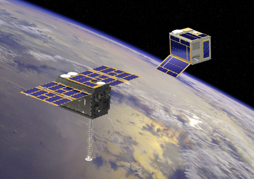
    The announcement comes following the launch of the European Space Agency’s (ESA) first Celeste LEO-PNT demonstration satellites (IOD-1 and IOD-2) on 28 March 2026, marking a key milestone in bringing LEO-based signals into the operational positioning environment and ESA’s first step toward extending satellite navigation into low Earth orbit.

    As the positioning ecosystem evolves, LEO-based signals are emerging as a complementary layer to established GNSS. Designed to augment systems such as Galileo, LEO satellites introduce a new building block characterized by lower orbital altitude, increased signal strength, and rapidly changing satellite geometry. GNSS remains the foundation of global positioning, delivering proven coverage and consistency at scale.

    This evolution is not only about additional signals, but about how positioning systems behave over time. The dynamic geometry of LEO satellites introduces new system characteristics that influence convergence speed, robustness, and performance in challenging signal conditions.

    Under its Navigation Innovation and Support Program (NAVISP) Element 2 (EL2) project, co-funded by ESA, u-blox is conducting a technical assessment of the role of LEO signals in multi-layer positioning architectures. This work forms part of a broader effort to bring LEO-PNT capabilities to mass-market GNSS receivers, combining emerging LEO signals with established GNSS systems.

    This includes early integration work on u-blox’s X20 GNSS platform, exploring how different signal types and frequency bands can be optimally incorporated into u-blox’s positioning systems. The scope of work includes:

    • Observation and characterization of emerging LEO signal transmissions
    • Analysis of interactions between LEO signals and GNSS measurements
    • Evaluation of the impact of dynamic satellite geometry on positioning performance
    • Exploring different system-level approaches for integrating LEO signals into future platforms 

    “U-blox is committed to advancing positioning technologies through focused research and collaboration,” said Jani Käppi, head of technology positioning at u-blox. “Our work within the ESA NAVISP framework allows us to better understand how emerging signal sources can complement GNSS and contribute to robust and reliable positioning performance.”

    U-blox expects to contribute to the development of the new LEO satellite ecosystem with significant innovation in the positioning solution, collaborating with key partners like ESA.

    The Celeste initiative

    The Celeste mission is ESA’s initiative for LEO-PNT (Low Earth Orbit Positioning Navigation and Timing) and is in its in-orbit demonstration phase. This first phase features a demonstration constellation of 11 satellites that will fly in low Earth orbit to test innovative signals across various frequency bands. Its goal is to advance satellite navigation concepts for resilient positioning and timing services.

    The Celeste in-orbit demonstration phase was approved at ESA’s Council at Ministerial Level of 2022. The fleet is being developed through two parallel contracts respectively led by GMV in Spain with OHB in Germany as core partner, and by Thales Alenia France as prime and Thales Alenia Italy as space segment responsible and involving over 50 entities from more than 14 countries.

    Celeste was further supported in ESA’s Council at Ministerial Level of 2025 (CM25), towards the implementation of the next phase: the LEO-PNT In-Orbit Preparatory phase.

    Celeste also contributes to one of the three core pillars of ESA’s new European Resilience from Space (ERS) initiative, endorsed at CM25. ERS addresses critical security and resilience needs for Member States while laying the groundwork for future European strategic space capabilities.

  • Kongsberg taps Advanced Navigation in multi-million deal for FOG INS

    Kongsberg taps Advanced Navigation in multi-million deal for FOG INS

    Advanced Navigation has finalized a multi-million deal with Kongsberg Defence & Aerospace to supply more than 50 Boreas D90 fiber-optic gyroscope inertial navigation systems (FOG INS) to strengthen Kongsberg’s Protector RS4 in high-threat, contested environments.

    As a strategic-grade INS, the Boreas D90 is engineered for the world’s most extreme environments, maintaining exact targeting and unwavering line-of-sight control for the Protector RS4.

    The Boreas D90 was selected not only for its superior precision in GNSS-denied conditions, but also for Advanced Navigation’s proven capacity to meet demanding delivery timelines. This agility is made possible by the company’s state-of-the-art, vertically integrated manufacturing. By controlling the entire production process, from sourcing raw components to assembly and testing in simulated EW environments, Advanced Navigation can rapidly scale output on demand and guarantee schedule certainty, a critical factor for Kongsberg.

    The Protector RS4 remote weapon system. Photo: Kongsberg)
    The Protector RS4 remote weapon system. Photo: Kongsberg)

    The Protector RS4 is the world’s most fielded remote weapon system, deployed across more than 30 nations and multiple domains. The highly flexible, modular system is designed to integrate a diverse range of payloads, including small and medium caliber systems and guided effectors. Its advanced, modular sensor suite (day, night, LRF) provides exceptional and customizable situational awareness.

    The fully stabilized 2 + 2 axis (detached line of sight) system allows the operator to maintain focus on a point of interest, independent of platform movement or the delivery solution for the specific system in use. The Protector RS4 is platform-independent and suitable for both land and sea applications.

    By integrating Boreas D90, the Protector RS4 achieves a new level of precision and survivability, sustaining locked targeting and georeferenced stability even when GNSS is compromised or denied. This enhancement positions Kongsberg’s Protector RS4 as one of the few systems globally capable of maintaining precision pointing under active electronic warfare attack.

    The deal supports the Global Supply Chain (GSC) Program, an initiative by the Australian Department of Defence designed to connect local suppliers with major global defense prime contractors. Advanced Navigation is based in Australia; Kongsberg is based in Norway.

  • VBOX Automotive launches NTRIP base station

    VBOX Automotive launches NTRIP base station

    VBOX Automotive has launched the NTRIP Base Station, expanding its GNSS test equipment range. The system combines a multi-constellation, multi-frequency GNSS engine with a built-in networked transport of RTCM via internet protocol (NTRIP) server.

    The equipment transmits real-time kinematic corrections over radio and cellular or Wi-Fi networks, supporting accurate real-time positioning across wider areas in varied environments compared to traditional radio-only systems.

    The base station launches in three models, with specifications designed to fit users’ needs. All systems combine quad-constellation, dual-frequency GNSS technology with built-in cellular and Wi-Fi connectivity. 

    • Internal GNSS antenna and 2.4 GHz radio
      Quick to deploy for short-range applications, for temporary or mobile testing. 
    • Internal GNSS antenna, no radio
      Compact and simple, ideal for NTRIP or semi-permanent installations with external high-power radio masts. 
    • External GNSS antenna, no radio 
      Optimized for permanent installations with tripod-mounted antennas for maximum satellite visibility, supporting NTRIP or external radio. 

    Compatible with VBOX 4, VBOX 3iS, and external GNSS rovers, the new NTRIP Base Station supports both MSM4 and MSM7 RTCM formats, has up to 24 hours battery life, and is rated to IP67 to handle the demands of long outdoor test sessions. 

    “We have developed the NTRIP Base Station in response to the growing need for accurate positioning in more varied test environments,” said Martin Papps, engineering director at Racelogic. “This new Base Station delivers centimetre-level accuracy without the range and line-of-sight limitations of traditional radio corrections.”

  • Precision cards and spoofing mitigation

    Precision cards and spoofing mitigation

    1. PRECISION CARD 

    High-accuracy positioning with the mosaic-X5 

    Photo:
    Photo: Gateworks

    The M.2 card GW16160 is the first Septentrio-based product from Gateworks, a U.S.-based manufacturer of single-board computers. The GW16160 provides reliable high-accuracy positioning powered by the mosaic-X5 GNSS module, a high-quality positioning solution for autonomous robots, UAVs and industrial mission-critical applications. The GW16160 allows engineers to integrate high-accuracy GNSS into edge systems without bulky external receivers or complex RF design. This ultra-low power card features an M.2 A/E-Key interface with USB 2.0 connectivity for plug-and-play integration. 

    Gateworks, gateworks.com; Septentrio, septentrio.com

    2. SPOOFING MITIGATION 

    Can protect GPS, BeiDou and Galileo signals

    Photo:
    Photo: Trimble

    The Trimble RTX-NMA (Navigation Message Authentication) mitigates spoofing attacks on GPS and BeiDou signals. RTX-NMA leverages the Trimble RTX correction service and enhances the security and integrity of GNSS navigation messages for all Trimble ProPoint receivers. Used in conjunction with Galileo OSNMA, users now have three constellations protected from spoofing attacks. Trimble RTX-NMA seeks to detect both fake GNSS signals and faulty ephemeris data through real-time authentication that ensures navigation messages from multiple RTX reference station receivers are genuine and trustworthy. It also encompasses faulty ephemeris detection, preventing unreliable data from being included in the correction stream. Enhanced security through advanced cryptographic techniques like AES encryption, and stream authentication, take it a step further. Trimble RTX-NMA is  compatible with various Trimble GNSS receivers using firmware version 6.40 or greater.

    Trimble, trimble.com 

  • infiniDome launches GNSS anti-jamming protection tech

    infiniDome launches GNSS anti-jamming protection tech

    infiniDome has introduced Aura, a new GNSS protection system built for platforms that cannot afford to lose their way. According to the company, this development comes at a time when GNSS interference incidents have surged by more than 400% across Europe and the Middle East over the past two years, making uninterrupted navigation a strategic necessity.

    Developed from years of field-proven operational experience, Aura is designed to redefine navigation resilience with smarter algorithms, faster interference response and a compact, rugged design capable of operating in contested environments.

    The system is available in two configurations: Aura, the enclosed version for rapid deployment, and AuraCore, the OEM module for integration. The system brings mission-grade protection to platforms ranging from small UAVs to large autonomous vehicles.

    Among several new capabilities, Aura features enhanced null-depth performance, enabling the system to withstand higher jamming power, and a new saving power mode that dynamically reduces energy consumption when no interference is present.

    “Aura isn’t just an upgrade; it’s a new philosophy,” said Omer Sharar, CEO of infiniDome. “It takes everything we’ve learned from real-world interference events and transforms it into a smarter, faster and more adaptive layer of defense. With Aura, we’re not just protecting GPS; we’re protecting autonomy itself.”

    Engineered for modern battlefields and complex environments, Aura introduces a new level of performance and resilience.

    Its adaptive algorithms ensure reliable navigation under evolving jamming conditions, while the optimized C-SWaP design keeps the system lightweight, low-power and mission-ready.

    Capable of mitigating interference from up to three directions per frequency simultaneously, Aura delivers protection that is powerful and efficient, tested and validated in live high-power jamming environments across multiple regions.

    These results position Aura as one of the most advanced and field-proven GNSS protection systems available.

    With Aura, infiniDome said it continues to advance its vision of navigation resiliency, ensuring that operators stay connected, coordinated and in control, even under severe electronic attack.

    Aura is available for early access evaluation and OEM integration, with full release scheduled for early 2026.

  • Sinclair Technologies Unveils 5G GNSS antennas

    Sinclair Technologies Unveils 5G GNSS antennas

    Sinclair Technologies has launched its SM 5G Family Tier, featuring the SM714 and SM2601 series antennas. The next-generation, multi-band, multi-port transport antennas are engineered to deliver superior connectivity, reliability and versatility for GNSS, 5G, LTE, Wi-Fi and other mission-critical wireless applications.

    The SM714 antenna. (Photo: Sinclair Technologies)
    The SM714 antenna. (Photo: Sinclair Technologies)

    The SM714 is a 4-in-1 low-profile customizable transit antenna that combines 5G/LTE, Wi-Fi and tri-band GNSS coverage in a single compact form. Supporting 617–5925 MHz, it enables seamless operation across all major 5G and LTE bands. The integrated high-gain tri-band GNSS module provides fast, accurate positioning, while the IP67-rated rugged housing ensures long-term durability. With its 2.6-inch ultra-low profile and single-hole mount, the SM714 is suitable for vehicles, fleet systems and connected mobility applications requiring a discreet, high-performance solution.

    The SM2601D is a 5-in-1 low-profile customizable antenna purpose-built for transportation, fleet and rail systems. It features five independent ports: one for PTC (219–223 MHz), one for Wi-Fi (2400–6000 MHz), one for GNSS, and two full-band cellular ports (694–2700 MHz) that support diversity and MIMO operation for multi-radio systems. This dual-cell configuration offers greater throughput, flexibility, and redundancy in complex communication environments. Housed in a fire-rated, weather-resistant black radome, the SM2601 ensures exceptional reliability in harsh operating conditions.

    Together, the SM 5G family ter delivers high performance and design flexibility for connected mobility, fleet tracking and smart infrastructure — extending Sinclair’s 75-year legacy of engineering excellence and innovation in RF antenna technology.

    “The launch of our SM 5G Family marks a bold step in redefining the boundaries of connectivity,” said Martine Cardozo, sales director, Sinclair Technologies. “By blending creativity with cutting-edge innovation, we aim to deliver highly reliable, all-in-one solutions that meet the evolving demands of a market in constant motion.”

    Key Benefits

    SM714 – Compact 5G / GNSS Transit Antenna

    • Wideband coverage: 617–5925 MHz across all major 5G/LTE bands
    • Tri-band GNSS (GPS, Galileo, GLONASS, BeiDou) for fast, precise positioning
    • Rugged IP67 housing ensures long-term reliability in harsh environments
    • Ultra-low 2.6 in. profile minimizes installation footprint and risk of damage
    • Ideal for vehicle rooftops, fleet applications, and mobile IoT systems

    SM2601 – Multi-Port Transport Antenna (Spec Sheet)

    • Five integrated ports: PTC, GNSS, Wi-Fi, and dual broadband 694–2700 MHz channels
    • Supports MIMO and multi-radio configurations for maximum system flexibility
    • Fire-rated, weather-resistant radome built for extreme operating conditions
    • High-gain GNSS with low-noise amplifier enhances accuracy and signal integrity
    • Optimized for rail, transit, and mission-critical fleet communications
  • Carlson offers Viking GNSS base/rover

    Carlson offers Viking GNSS base/rover

    Carlson Software has released the Viking as its new flagship GNSS base/rover receiver to meet demanding needs in survey, engineering, GIS, construction, and other applications. Engineered for centimeter‑level accuracy and providing an RTK fix in challenging environments, the Viking uses TripleFix technology, Carlson’s proprietary GAMA RTK engine, advanced hardware, robust connectivity, and intelligent processing.

    The Viking also represents the company’s second GNSS solution, after the VASCO-B base station. It is manufactured in the United States at Carlson’s headquarters facilities in Maysville, Kentucky.

    “Precision, performance and reliability, all while bringing manufacturing back to the USA,” said Bruce Carlson, company founder. “The Viking is more than a positioning system. It’s a powerful tool designed to enhance your efficiency, streamline your workflows, and deliver unparalleled accuracy.”

    Viking highlights

    • The Dual GNSS RTK modules and three separate RTK engines, provide exceptional horizontal and vertical accuracy, providing a “Triple-Fix” and essentially eliminating false fixes
    • Calibration-free tilt compensation delivers impressive precision even when surveying at up to 60° of inclination
    • Dual hot-swappable batteries: 10+ hours of runtime
    • IP67-rated, MIL-STD-810G tested
    • Use as a base or a rover with communication options including 400 MHz and 900 MHz radio, internal mobile data modem, Bluetooth and Wi-Fi
    • Integrates with Carlson SurvPC and Layout field software, and features a powerful web-based UI for remote setup and monitoring.

    The Carlson Viking is available for pre-order through Carlson dealers and distributors worldwide.

  • ProStar, Tersus partner on precision mapping for utilities

    ProStar, Tersus partner on precision mapping for utilities

    ProStar Holdings is partnering with Tersus GNSS, a global manufacturer of patented GNSS technologies. ProStar is the developer of PointMan Precision Mapping Solutions and the LinQD enterprise integration platform.

    The collaboration will deliver a complete precision mapping solution to the utility and critical infrastructure industries worldwide, the companies announced.

    The partnership is designed to integrate Tersus’s survey-grade GNSS receivers with ProStar’s PointMan, providing an affordable, field-ready solution available through Tersus’s international distribution network. Tersus GNSS has operations in China, the United States, and Australia, and is recognized for its innovation in GNSS receiver and base station technology for high-precision positioning applications.

    The collaboration represents the latest step in ProStar’s strategy to expand its partnerships through the LinQD open API integration platform, delivering its technologies in one connected precision mapping solution.

    ProStar’s LinQD platform is designed to enable seamless interoperability between emerging technologies and legacy systems, creating a robust global ecosystem for geospatial intelligence. By uniting equipment manufacturers and service providers under this initiative, ProStar continues to strengthen PointMan’s position as a premier mapping solution for the critical infrastructure industry worldwide.

  • KYOCERA AVX launches LDS cap antenna for Iridium satellite IoT applications

    KYOCERA AVX launches LDS cap antenna for Iridium satellite IoT applications

    KYOCERA AVX has launched an LDS cap antenna and evaluation board optimized for Iridium satellite IoT applications and designated as Iridium Qualified Antenna products for Iridium Certus 9704 modules.

    The antenna was developed to provide Iridium with an embedded antenna optimized for low-Earth-orbit (LEO) satellites used to provide seamless connectivity and data exchange for IoT devices anywhere in the world. The new LDS cap antenna developed for Iridium outperforms the ceramic patch antennas traditionally used in these applications.

    Manufactured using laser direct structuring (LDS) technology — an efficient process for creating complex, compact, lightweight, wide-bandwidth, and high-gain 3D antenna designs on myriad substrates — the new LDS cap antenna is smaller and lighter than ceramic patch antennas and exhibits excellent right-hand circular polarization (RHCP) and superior gain from zenith to horizon, which maximizes satellite visibility and reliability and is especially beneficial for improving the connectivity of LEO satellites at low elevation angles. It also exhibits wider bandwidth and higher radiation efficiency than patch antennas.

    The new KYOCERA AVX LDS cap antenna developed for Iridium supports GNSS (1,559–1,610MHz) and Iridium (1,616–1626.5MHz) frequencies with ~2dBi peak gain and 60% efficiency, and delivers reliable performance in challenging environments, including over metal. It’s rated for 4W power handling, 50Ω feed point impedance, and operating temperatures extending from -40° to +85°C. It’s also proven to withstand exposure to high temperatures, high humidity, and salt spray, compliant with the latest RoHS and REACH directives, and packaged and shipped on tape and reel for automated assembly with reflow soldering.

    The on-board antenna has a small, lightweight form factor with a unique design that measures 35.7 mm in diameter and 17.98 mm high, weighs 6.85g, facilitates easy SMT assembly, and allows device manufacturers to locate components on its underside, saving space on the main PCB board.

    The new antenna is expressly designed for satellite connectivity, targeted for satellite IoT applications, and well-suited for applications including telematics, asset tracking, remote monitoring, smart farming and smart city applications. Earlier this year, it was shortlisted for Electronic Specifier’s Electronics Excellence Awards in the passive product category.

  • Quectel-Swift partnership now includes RTK corrections

    Quectel-Swift partnership now includes RTK corrections

    Quectel Wireless Solutions is partnering with Swift Navigation to deliver Quectel’s Real-Time Kinematic (RTK) Correction Solution, which enables cost-effective, centimeter-level positioning accuracy for a new generation of IoT applications.

    In January, the companies announced integration of Swift’s Skylark Precise Positioning Service with Quectel’s high-precision GNSS modules.

    The collaboration allows Quectel to simplify the complexities of high-precision GNSS by bundling its RTK modules and antennas with Swift’s Skylark Precise Positioning Service, offering equipment manufacturers a streamlined, end-to-end solution for RTK adoption and deployment.

    Partnering with Swift enables Quectel to tailor solutions for specific applications, helping equipment manufacturers simplify the complexities of RTK adoption and deployment. The Quectel RTK Correction Solution is designed to support a wide range of mass-market applications, including robotics, automotive, micro-mobility, precision agriculture, surveying, and mining.

  • Hexagon to acquire Inertial Sense, strengthening its positioning portfolio

    Hexagon to acquire Inertial Sense, strengthening its positioning portfolio

    Hexagon, a global leader in measurement and positioning technologies, has entered an agreement to acquire Inertial Sense, a provider of tactical-grade global navigation solutions and inertial navigation systems (INS), to strengthen the breadth of its positioning portfolio.

    Inertial Sense’s capabilities seek to complement Hexagon’s assured positioning, navigation and timing (PNT) portfolio, which provides an affordable, high-performance navigation solution to users across aerospace and defense, robotics and UAV industries.

    Inertial Sense has established itself as a trusted provider of high-performance navigation solutions across a wide range of defense and commercial applications, with more than 30,000 inertial systems deployed worldwide. Its patented designs and proprietary technology enable tactical-grade solutions for space-constrained applications, delivering centimeter-level accuracy with a competitive price point.

    “Assured PNT is critical to success of our customers,” said Anders Svensson, president and CEO of Hexagon. “The team at Inertial Sense has developed an impressive array of GNSS+INS solutions which address the assured PNT requirements of our customers and fit seamlessly into our aerospace and defense product portfolio, while also providing opportunities for expansion into robotics and UAV applications.”

    Inertial Sense, headquartered in Utah, is expected to generate revenues of around $5 million in 2025, with strong growth rates and profitability in line with Autonomous Solution’s average levels. Inertial Sense will be reported within Hexagon’s Autonomous Solutions business area. Completion of the transaction is subject to regulatory approvals and other customary conditions and is expected to be finalized in the first half of 2026.

  • Quectel unveils smart single board computers to accelerate device development

    Quectel unveils smart single board computers to accelerate device development

    Quectel Wireless Solutions, a global IoT solutions provider, launched three smart single board computers Tuesday designed to speed product development and reduce costs.

    The QSM368Z, QSM560DR and QSM668SR offer developers connectivity, operating system and memory options for various applications, the company said.

    “These boards are fully finished hardware that can be easily integrated inside customers’ larger systems across a wide range of IoT use cases,” said Raymond Wang, head of Smart SoC at Quectel Wireless Solutions. “Provided in a ready-to-use, single, low-cost platform, these boards are helping to simplify and accelerate the development process for IoT devices of all types, significantly reducing development time with rapid prototyping and cutting development costs.”

    The QSM368Z features the Rockchip RK3568 IoT processor with a quad-core ARM Cortex-A55 CPU, ARM Mali G52 GPU, 8M ISP HDR and 1 TOPS NPU. The board supports Linux and Android operating systems.

    The device includes triple-screen concurrent display support, 1,000 Mbps Ethernet and 4K video encoding. Built-in Wi-Fi 5 and Bluetooth 4.2 come standard, with optional support for Quectel LTE Cat 1, LTE Cat 4, Wi-Fi 6 and GNSS modules.

    The QSM368Z measures 120mm x 100mm x 22.25mm, weighs about 90 g and operates in temperatures from -10 C to +75 C. Applications include IoT gateways, smart displays, industrial terminals, safety monitoring systems, NAS, NVR/DVR and automotive NVR solutions.

    The QSM560DR features 12 TOPS NPU and supports Ubuntu, Android and Windows. The platform’s multi-mode 5G capability supports both NSA and SA networks, with 3G and 4G fallback. Wi-Fi 6E with DBS and 2×2 MU-MIMO technologies enable faster data transmission.

    The device supports downlink speeds up to 2.5 Gbps on 5G NSA. It measures 120.5mm x 106mm x 22.5mm, weighs approximately 120 g and operates from -35 C to +75 C. Target markets include smart manufacturing, retail analytics, robotics and connected infrastructure.

    The QSM668SR supports Android, Linux and Ubuntu and features 1.1 TOPS NPU. The board supports LTE Cat 4, Wi-Fi, Bluetooth and GNSS. Under LTE Cat 4, the board achieves uplink speeds up to 150 Mbps and downlink speeds up to 50 Mbps. Bluetooth 5.0 is included.

    Optional GNSS functionality provides positioning through GPS, GLONASS, BDS, Galileo, QZSS and SBAS satellite constellations.

    The device includes HDMI, camera inputs, Ethernet, UART, USB, I²C, RS232, RS485, CAN, SD and SIM interfaces. It measures 102mm x 100mm x 23mm, weighs approximately 97.7 grams and operates from -20 C to +75 C. Applications include IoT gateways, smart home systems, industrial control terminals, retail solutions, safety monitoring, vehicle equipment and logistics devices.

    Quectel also provides antennas for cellular, Wi-Fi, Bluetooth and GNSS networks, plus custom antenna design and optimization services.