Organized by Professor Zak Kassas from the University of California, Riverside, the workshop will feature presentations and panels by experts and leaders from government (National Science Foundation, Office of Naval Research, Air Force Research Laboratory, Department of Transportation), industry (Google, Daimler, and Ford) and academia (The Ohio State University, UC San Diego, University of Southern California).
The workshop will discuss opportunities and challenges (technical, commercial, ethical, and legal) associated with developing fully autonomous systems that are cognizant and trustworthy for safety-critical applications. Examples include unmanned aerial vehicles (UAVs), self-driving cars and unmanned underwater and surface vehicles.
Kassas, director of the Autonomous Systems Perception, Intelligence, & Navigation Laboratory (ASPIN), leads a team of researchers developing reliable and accurate navigation that exploits existing signals of opportunity, rather than GPS, to meet the stringent requirements of fully-autonomous systems, such as UAVs and self-driving cars.
With personal or work-issued smartphones, more than 4,000 employees can now use a corporate app to easily find available rooms and spaces to work in the 500,000-square-foot, 20-floor, four-building Stockholm headquarters of telecom company Ericsson.
The Senion StepInside indoor positioning system, designed by partner Flowscape, helps Ericsson employees reduce wasted time searching for people, places or things, thereby increasing productivity.
The StepInside software development kit (SDK) offers location readings in latitude, longitude and floor level in real time. The SDK can easily be integrated into any smartphone application. StepInside relies on an advanced sensor fusion algorithm that works with the smartphone’s movement and radio sensors to provide accurate and robust positioning.
“Indoor positioning technology is perfect for large offices with multiple floors, offices, and meeting spaces — the bigger and more intricate the better,” said Christian Lundquist, CEO and co-founder of Senion. Ericsson’s StepInside implementation is part of the company’s larger global platform designed to enable rapid IoT application development.
The system as implemented today is the starting point for a bigger roll-out with additional workplace enhancements at Ericsson.
Senion’s comprehensive IPS services include analytics, wayfinding, geofencing, friend-finder and tracking. With more than 300 indoor positioning system installations globally, Senion has worked closely with shopping malls, hospitals, corporate campuses and more to improve workflows. Senion is headquartered in Linkoping, Sweden, and San Francisco.
Laser Technology’s MapSmart app for Android is a tool for expert field data collection without complicated equipment, the company said.
The software is designed for quick and accurate mapping of anything, including stockpile volumes, with or without GPS coordinates for every data point.
The survey-quality mapping app, using the smart device’s internal GPS or the user’s own external GPS, integrates with LTI TruPulse lasers and enables users to establish an origin and begin capturing field data in minutes.
MapSmart:
offers four mapping methods to accommodate user preferences
provides an intuitive interface with icons and buttons
organizes and classifies data to ease the process of decrypting field measurements in the office
enables real-time addition of height and missing line values to mapped features
delivers advanced image capabilities, including tablet photo association with data points and TruPoint 300 image integration
supports a variety of report formats and wireless data transfer.
The smart features and remote-fire capabilities are especially useful for stockpiles, where users can measure and calculate the volume and tonnage of any material from a safe location.
Texas company Continental Electronics has patented a transmitter system and method for construction of low-frequency antenna towers significantly lower in height than previously needed for identical coverage.
“One obstacle to deploying eLoran systems has been the sheer height needed for the transmission towers, each of which requires significant acreage,” said Mike Rosso, vice president of Dallas-based Continental Electronics. “Tower height and land required not only represent serious financial costs, but in some cases adequate space is simply not available. Our technology can reduce tower height and real-estate requirements. With this, reducing antenna tower height by half would reduce required land area to one quarter.”
The method uses digital adaptive correction, solid-state amplifiers, envelope modulation and a wideband matching network. Any linear distortions within usable bandwidth are removed by digital adaptive correction, according to the company. Envelope modulation is required to achieve linearization for any signal type including Loran. A wideband matching network tunes out capacitive reactance from electrically short antennas, transforms impedance to a value suitable for the transmitter, increases usable bandwidth and suppresses harmonics and out-of-band emissions.
“We hope this will aid moving forward eLoran deployments around the world,” Rosso added. “Widely used satellite-based navigation and timing services are vulnerable to jamming, spoofing and other forms of interference. The world needs a more resilient solution as afforded by ground-based solutions such as eLoran.”
LORAD++ CORE, an alternative PNT source to combat GNSS denial: 60 x 30 x 8 millimeters
A new series of integrated eLoran/Chayka/GNSS receivers emphasize low-power requirements and small size for alternative positioning, navigation and timing (PNT) to reduce risks of GNSS denial.
Loradd++, from Netherlands-based firm Reelektronika, consists of a receiver board of 60 x 30 x 8 millimeters, consuming less than 500 milliwatts (3.3 volts) in continuous operation. The Loradd++ can be used with either E-field or H-field antennas, features dual serial interface for integrated systems, and is connectable to certain miniature GNSS receiver modules.
eLoran and Chayka are recognized as alternative PNT systems, but current receivers on the market are large in comparison to miniature GNSS devices. Chayka is a Russian terrestrial radio navigation system, similar to Loran-C. It operates on similar frequencies around 100 kHz, and uses the same techniques of comparing both the envelope and the signal phase to accurately determine location.
The first of a new series of receivers is Reelelektronika’s Loradd++/E, which is an integration of the Loradd++ with an E-field antenna housed in a small single radome that can be connected via a data cable (up to 150 meters) and a dongle to a USB port on a PC. The radome contains a u-blox M8T GNSS receiver with antenna and measures 135 millimeters in height and 85 millimeters in diameter. The Loradd++/E needs less than 700 milliwatts at 4-16 volts.
Reelektronika manufactures eLoran equipment for users, service providers and surveyors. The company developed the eDLoran system. eDLoran works with existing Loran transmitter stations and yields differential Loran position and navigation accuracies comparable to GPS; see the cover story of the July 2014 issue of GPS World. The system can thus be considered as a robust backup for GPS.
The U.S. Department of Transportation (DOT) is studying responses to its November 2016 request for information concerning back-up systems for GPS. DoT is investigating possibilities and practicalities of using one or more positioning, navigation and timing (PNT) technologies to ensure PNT resiliency for critical infrastructure in the event of a temporary disruption in GPS availability.
The filing period closed Jan. 30.
RFI Response
Several companies responded to the RFI. Statements from Satelles, NextNav, NovAtel, Allied Partners, Harris, UrsaNav, and Orolia dba Spectracom were not made public because they “contain confidential business information data.”
Statements are available at the web page from Oakridge National Laboratory, UrsaNav and iPosi, SAE International, the GPS Innovation Alliance and Locata Corporation, which made its response openly available “to kick off the necessary public discussion.”
Senate Inquiry
At a Feb. 8 Commerce Committee hearing, Sen. Roy Blunt asked DoT Inspector General Calvin Scovel about progress on GPS back-up, which DoT and the Deputy Secretary of Defense announced they would “be working on” in 2015. Scovel responded with information about the Federal Aviation Administration’s next-gen plan, which did not address the question.
Sen. Blunt then asked Scovel to submit a written answer for entry into the final record of the hearing: “My question for the record will be that this commitment made in 2015 concerned about the current dependency that so many people have with GPS, is ‘Are they moving forward with a backup system if the current GPS system goes down?”
Orolia has synchronized a Spectracom SecureSync high-precision time server with the new Iridium Satelles Satellite Time & Location (STL) time synchronization signal powered by Iridium satellites in several indoor environments in the field. Configured with an embedded STL receiver and a small patch antenna, the SecureSync synchronized with the STL signal in several challenging indoor locations. Indoor success can be attributed in part to use of a low-Earth orbit satellite-based signal 1,000 times stronger than GPS.
The first successful synchronization was in the interior of a building in one of the most challenging urban canyons on Earth: downtown Manhattan on the 7th floor of the New York Stock Exchange. The second was in the interior of a conference center with multiple sources of potential signal interference during The Institute of Navigation event in Monterey, California. Additional successful indoor timing signal synchronization locations include MiFiD2 events near the Paris Stock Exchange, a multi-story building and inside Gibson Hall in downtown London.
More GNSS challenged locations to come, the two companies promise.
Other satellite signals — notably GNSS — have limitations indoors. The Satelles STL signal uses the narrow-band paging channels of Iridium, a one-way transmission from the satellite with a very high gain system. The STL signal is completely different from the wide band, lower gain two-way channel of the Iridium phone. The STL signal is 1,000 times stronger than GPS because it originates from the Iridium constellation of 66 satellites orbiting in a low earth orbit. It is also encrypted for high security, which greatly enhances the resilient PNT capabilities of the Spectracom product lines, specificallly the SecureSync precision time and frequency reference. SecureSync with integrated STL synchronization is available to order from the Spectracom website or by contacting a representative.
“The new STL signal is the ideal solution for those needing increased security and reliability, applications such as high frequency securities trading, financial transaction time-stamping compliance and critical infrastructure timing,” said John Fischer, vice president of Orolia for advanced R&D. “It is not only an additional signal to back up traditional GNSS, it is also stronger and more secure, adding significantly to the resiliency of high performance systems and networks that must rely on precise time synchronization.”
Having proven the ability to provide a strong and reliable alternative signal in various indoor field locations, the new globally accessible STL signal adds a significant safety net to any critical GNSS application. Adding to the mix of signals of opportunity the resiliency of positioning and timing for financial, defense and critical infrastructure is greatly enhanced.
“Orolia is focused on providing Resilient PNT solutions, and by combining and layering technology in innovative ways we help our customers meet their mission goals,” said Rohit Braggs, vice president of Orolia’s PNT networks and sources. “This new satellite-based service provides a unique signal that augments Spectracom systems, enhancing our ability to effectively mitigate emerging GPS and GNSS threats.”
Orolia is the parent company of Spectracom, McMurdo, Kannad, and Sarbe brands, focused on resilient positioning, navigation and timing (RPNT) solutions that improve the reliability, performance and safety of customers’ critical, remote or high-risk operations.
Satelles has developed and deployed a real-time PNT service based on low-Earth orbit satellites, the Iridium constellation. Satellite Time and Location (STL) signals are highly secure, penetrate deep indoors, and are available anywhere on Earth. Satelles partners with other companies to deliver secure time and location capabilities to government and commercial users worldwide.
In many respects, the story of innovation in electronics has been about miniaturization: designers pack more features, functionality and performance into electronics that are smaller, lighter and more power-efficient. However, this has traditionally been applied only to a limited extent to atomic clocks, which electronic devices employ to maintain correct time if their GPS signal is lost.
Atomic clocks have significant limitations in terms of scalability and portability, so until recently the best designers could use were ovenized crystal oscillators (OCXOs), which were smaller, lighter and consumed less power than atomic clocks.
However, they were also less accurate and precise. Now, micro-atomic clocks enable addressing an entirely new range of use cases. A miniature atomic clock (MAC) is not the same clock made smaller; it’s a different clock.
Timing Quality Measurements. A clock is accurate if its time agrees with a standard such as cesium reference or GPS. A clock is precise if its interval between ticks — its frequency of oscillation — is the same as a reference clock’s interval, even if the reference clock is inaccurate.
A stern measure of precision is syntonicity, which is a measure of consistency in the occurrence of ticks within the environment. Radar requires syntonicity. To obtain a clear image of a scanned object, the receiver of the signal bounced off the object needs to know the exact instant the associated pulse was sent from the transmitter.
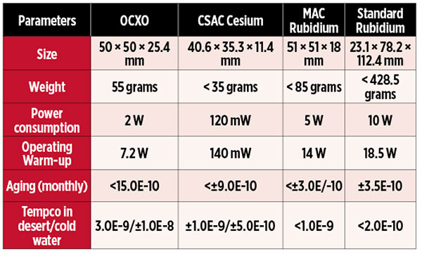
It’s All About SWaP. One challenge of any timing miniaturization is whether the clock’s size, weight and power (SWaP) meet the needs of a given application. For example, a cesium chip-scale atomic clock (CSAC) is the smallest sized atomic clock in the current market; see the table below. By contrast, the rubidium MAChas the lowest power consumption after the CSAC (that is, 40 times more than CSAC). Before the introduction of the MAC, the standard rubidium clock was the clock with the lowest power consumption and with similar performance.
Performance metrics of clock technologies.
Benefits of small SWaP values are easily seen. Devices that required an external power source can now operate on batteries, without a heat sink. A person or a drone can now carry devices that were stationary or required a truck.
Improvements in SWaP only matters if application requirements for accuracy and precision are also met. What happens if an application’s GPS access is lost? All clocks tend to drift once they no longer reference an external time source. This is known as aging. A key factor that affects aging is temperature. While operating in extreme environments (such as, deserts, high altitudes or under sea), the rate of timing error increases due to temperature variation; the amount of temperature-related error is called tempco.
The availability of clocks with tight specifications signifies that designers can now employ accurate and precise timing in many ways and places. However, one must specify, analyze and select the clock carefully to meet the requirements of the application. For example, replacing the OCXO with a standard rubidium clock is typically not an option because the standard rubidium clock does not fit in to the OCXO form factor. Designers may consider replacing an OCXO with a CSAC or MAC if greater portabiity and better timing accuracy and precision are the key requirements.
The choice often comes to one between the CSAC’s lower power consumption and weight versus the MAC’s superior aging performance in the event of GPS loss. The difference between the two clocks lies in how gas atoms trapped into resonance by a microwave synthesizer are excited and then interrogated, a concept known as coherent population trapping.
Applications suitable for rubidium atomic clocks (MAC) include the following.
Cellular Base Stations. Rubidium atomic clocks can meet the tight timing requirements for 4G-/LTE-base stations up to 24 hours (even longer for 3G and 4G). Moreover, rubidium’s superior aging ensures longer holdover, meaning the network can remain operational for longer even if the sync reference is lost. The MAC’s lower power consumption compared to a standard rubidium clock also contributes to a lower power and heat density overall, potentially reducing the need for external cooling while increasing the electronic reliability and reducing its size. Low tempco is also critical, considering the environments in which these stations often operate.
Radar Base Stations. Radars require highly precise synchronization between transmitter and receiver signals. MACs are increasingly replace OCXO in these applications, which also benefit from the technology’s lower power.
Applications suitable for CSACs include these.
IED Jammers. Low-power consumption is critical in dismounted intelligent electronic devices (IED) jammers, which must be small, light and battery-powered. Yet they must be precise enough to tightly synchronize and allow pre-defined time slots in the signals (known as look windows) to allow friendly communications through.
Dismounted Military Radios. Portability and precise synchronization are critical, especially given the higher bandwidth waveforms required to handle encoded video and other data-rich signals.
Tactical Unmanned Aerial Vehicles (UAVs). In addition to relying on GPS (or clock holdover) for navigation, unmanned aircraft drones also require precise timing for their encoded data-rich and video communications. They also present challenges in terms of the size, weight and power consumption of payloads.
Undersea Seismic Sensing. Differences in time measurements of acoustic pulses across sensor nodes are used to map subterranean formations such as oil deposits. In the absence of GPS under water, precise synchronization and very good aging performance are critical to harvesting reliable data during the duration of a survey deep under the ocean.
More innovation lies ahead! Low-powered SWaP-friendly atomic clocks are revolutionizing the world without compromising clock performance, enabling many mission-critical applications.
RAMKI RAMAKRISHNAN is director of product line management and business development, Clocks Business Unit, Microsemi Corporation.
Micro-Technology for Positioning, Navigation, and Timing towards PNT everywhere and always; slide from a 2014 DARPA presentation to the Space-Based Positioning, Navigation and Timing National Advisory Board (Image: Robert Lutwak, DARPA Micro-Technology Office). Click to enlarge.
The U.S. Defense Advanced Research Projects Agency (DARPA) has initiatives underway with a dizzying number of technologies, all seeking to reduce reliance on GNSS in challenged environments. Using cold atom interferometry and other techniques to reduce the size, weight and power consumption (SWAP) as well as cost of inertial sensors, employing other signals of opportunity (SOI), chip-scale atomic clocks (CSAC), micro-electro-mechanical systems (MEMS) and more, the Micro-Technology Office (MTO) and the Adaptable Navigation Systems (ANS) projects press relentlessly forward to provide U.S. forces with PNT “everywhere and always.”
DARPA’s ANS initiative explores tools to enable use of the many sensors available to warfighters and first reponders. “Over the past two decades, the field of robotics has done a lot for extracting features out of imagery and tracking those features as the robot moves through a given environment,” said Lin Haas says, program manger at the Strategic Technology Office. “We’ve been building upon those capabilities and using the capabilities for the purposes of navigation.”
ANS seeks to provide GPS-quality PNT to military users regardless of the operational environment. It addresses three basic challenges through its Precision Inertial Navigation Systems (PINS) and All Source Positioning and Navigation (ASPN) efforts:
better inertial measurement units (IMUs) that require fewer external position fixes;
alternate sources to GPS for those external position fixes;
new algorithms and architectures for rapidly reconfiguring a navigation system with new and non-traditional sensors for a particular mission.
PINS is developing an inertial measurement unit (IMU) that uses cold atom interferometry for high-precision navigation without dependence on external fixes for long periods of time. Atom interferometry involves measuring the relative acceleration and rotation of a cloud of atoms within a sensor case, with potentially far greater accuracy than today’s state-of-the-art IMUs.
A company called AOSense has applied cold-atom interferometry to IMUs and demonstrated sensors that support system drifts of 5 meters per hour, by using quantum physical properties to measure the relative acceleration and rotation of a cloud of laser-cooled atoms. The next challenge is shrinking the lasers to microsystem size, because the concept requires three lasers generating five beams to cool and move the atoms through interferometers to determine movement and rotation of the device.
Because even long-duration IMUs require an eventual position fix, the ASPN effort is developing sensors that use signals of opportunity — non-navigation signals from sources like television, radio and cell towers, and satellites, as well as natural phenomena, such as lightning.
“Our navigation systems tend to be finely tuned, and as a result they are fairly brittle in terms of accepting new sensors without a lot of hands-on time to make it work,” said Haas.
Flexible Combinations. Integrating and tuning these diverse sensors, maps and other components into a navigation system is expensive and slow, producing platform and mission-specific solutions. The ASPN effort is also developing new fusion algorithms and plug-and-play processing architectures for rapid integration and near-real-time reconfiguration or upgrading of sensors, IMU devices, maps and databases on a navigation system. With flexible combinations of existing and new navigation sensors, ASPN can produce improvements in accuracy, robustness and cost of navigation systems across a range of platforms, environments and missions.
PINS is working towards a final subsystem demonstration in fiscal year 2017. ASPN has completed multiple field demonstrations on air, land and sea platforms, with final demonstrations scheduled in fiscal 2017.
Chip-Scale Atomic Clocks. Meanwhile, last year DARPA launched the Atomic Clocks with Enhanced Stability project under the direction of Robert Lutwak (recipient of GPS World’s Leadership Award for Products in 2012). “If ACES is successful, virtually every Defense Department system will benefit,” Lutwak said.
ACES seeks to create palm-sized, battery-powered atomic clocks that perform up to 1,000 times better than the current generation, employing experts and techniques from atomic physics, optics, photonics, microfabrication and vacuum technology. “All of our modern communications, navigation and electronic warfare systems as well as our intelligence, surveillance and reconnaissance systems depend on accurate time-keeping,” Lutwak added.
Pseudolites. In other, non-DARPA initiatives around the Department of Defense, the Command and Control Directorate of the Army’ Communications-Electronics Research, Development and Engineering Center (CERDEC) is “very concerned about what happens when we lose GPS,” according to Paul Olson. CERDEC is developing vehicle-based, dismounted and anti-jam antenna pseudolite systems.
The pseudolites have completed feasibility testing and entered acquisition for transmitters, receivers and command-and-control. Rockwell International and L-3 are developing the transmitters. The effort seeks to use current military GPS receivers with software modified to accept pseudolite signals.
This article draws on interview quotes that appeared in Signal magazine of the Armed Forces Communications and Electronics Association.
Iridium Communications Inc. has successfully launched its first 10 Iridium NEXT satellites, which will support real-time automatic dependent surveillance broadcast (ADS-B) operations in oceanic regions.
Iridium NEXT is the company’s next-generation satellite constellation, replacing and enhancing its existing network of low-Earth orbit satellites spanning the entire globe — the largest commercial satellite constellation in space.
A SpaceX Falcon 9 rocket lifts off from Space Launch Complex 4E at Vandenberg Air Force Base, California, Jan. 14. (Photo: SpaceX)
The satellites were delivered into low-Earth orbit an hour after a SpaceX Falcon 9 rocket lifted off from Vandenberg Air Force Base in California at 9:54:39 a.m. PST on Jan. 14.
The launch is the start of a series of Iridium NEXT launches scheduled over the next 18 months, and marks the beginning of one of the biggest “tech refreshes” in history, completely replacing the only satellite constellation providing 100-percent global communications coverage.
Once fully deployed, Iridium NEXT will enable a new broadband multi-service capability called Iridium CertusSM, while providing the technical flexibility to support innovative new services and technologies from Iridium’s extensive partner network.
Aircraft surveillance
Among those technologies is a unique hosted payload from Iridium’s partner Aireon, which will provide a real-time global aircraft surveillance service, extending aircraft visibility across the planet.
Aireon’s space-based ADS-B receiver network will relay signals from all ADS-B equipped aircraft to controllers worldwide, allowing 100 pecent global air traffic surveillance. (Image: Aireon)
According to Aireon, its space-based ADS-B network will transform air traffic management capabilities, providing air traffic surveillance and flight tracking across 100 percent of the planet. Currently, more than 70 percent of the earth, including oceanic and remote airspace, has no existing air traffic surveillance.
The first 10 Iridium NEXT satellites were delivered to a 625 kilometer (km) temporary parking orbit where they will be tested and exercised by Iridium over the coming weeks. Upon meeting testing and validation requirements, the satellites will then be moved into their 780-km operational orbit and begin providing service to Iridium’s customers.
As part of this testing and validation process, Aireon’s ADS-B receivers, which were manufactured by Harris Corporation, will provide air traffic surveillance data through the Aireon network to the Service Delivery Points (SDPs) at partners NAV CANADA, NATS, ENAV, the Irish Aviation Authority (IAA), as well as the Federal Aviation Administration (FAA) William J. Hughes Technical Center in Atlantic City, New Jersey.
One by one, the new satellites will be positioned near a current generation satellite, each moving at approximately 17,000 miles per hour as testing begins. Iridium’s inter-satellite communication links from nearby satellites will be repositioned to point to the new Iridium NEXT satellite as it prepares to take over service. Existing satellites will eventually be de-boosted and de-orbited.
“Today Iridium launches a new era in the history of our company and a new era in space as we start to deliver the next-generation of satellite communications,” said Matt Desch, chief executive officer of Iridium. “We have been working endless hours for the last eight years to get to this day, and to finally be here with ten Iridium NEXT satellites successfully launched into low-Earth orbit is a fulfilling moment. We are incredibly thankful for all of the hard work from our team, as well as our partners, to help us achieve this milestone.”
Both Thales Alenia Space, System Prime Contractor for the program, and their subcontractor for production, Orbital ATK, have been integral in the development of the Iridium NEXT program, from the design and manufacturing of the Iridium NEXT satellite vehicles to managing an 18-station, state-of-the-art assembly line production system.
“Leading a worldwide team to manufacture, assemble, test and prepare each satellite for this moment has been incredibly exciting,” said Bertrand Maureau, executive vice president of telecommunications at Thales Alenia Space. “We are very proud to have conducted such a unique program, in terms of scale and complexity as well as to have successfully completed the end-to-end whole constellation on-ground validation. The system is fully tested, and the compatibility of Iridium NEXT with the Block-1 operating satellites has been perfectly demonstrated. It has truly been an honor, and we are looking forward to completing the rest of the Iridium NEXT constellation through 2017 and early 2018.”
“We are proud to be a part of this revolutionary satellite program,” said Frank Culbertson, president of Orbital ATK’s Space Systems Group. “Seeing these first ten satellites launch successfully into space is the result of a unique assembly-line process at our satellite manufacturing facility that represents a remarkable achievement. We look forward to seeing the innovative solutions these satellites, which are great examples of leading-edge technology and manufacturability, will enable.”
In addition to partnering with Thales Alenia Space as System Prime Contractor, Iridium has partnered with SpaceX for the launch of 70 Iridium NEXT satellites on its Falcon 9 rocket.
“We are very proud to be chosen as the launch provider for the entire Iridium NEXT program and are excited about today’s successful first launch,” said Gwynne Shotwell, President of SpaceX. “Iridium was one of SpaceX’s first customers, and working alongside them to deliver one of the largest aerospace projects underway is an exciting moment for us at SpaceX.”
Iridium and SpaceX are partnered for a series of seven launches, deploying ten Iridium NEXT satellites at a time. The next major milestone will be the completion of on-orbit testing of these satellites, to validate performance requirements are met.
The second Iridium NEXT launch will be scheduled after testing is completed in April. The entire Iridium NEXT network is scheduled to be completed by mid-2018.
A strategic alliance announced on Dec. 15 between Orolia and Satelles includes product development and go-to-market activities of positioning, navigation and timing (PNT) solutions provided by the Iridium satellite constellation, independent of GPS/GNSS signals. The companies intend to provide PNT solutions to military, defense, government and commercial customers worldwide.
Orolia, the parent of GNSS-active companies Spectracom and Spectratime, among others, has formed a strategic alliance, including an equity investment, with Satelles Inc. to develop, market and sell PNT solutions based on Satelles’ satellite time and location (STL) signal technology.
STL is a unique space-based PNT technology that provides location and timing data independent from traditional GPS and other GNSS satellite signals. By using STL, Orolia’s Spectracom and McMurdo solutions will, according to the company, be less susceptible to vulnerabilities such as spoofing, interference and jamming that are associated with GPS/GNSS.
Based on the low-Earth orbit (LEO) Iridium satellite constellation, STL signals are up to 1,000 times stronger than GPS/GNSS; this signal strength, due in part to the constellation’s closer proximity to users, helps to prevent jamming and enables signal reach into buildings and other difficult locations. STL’s additional cryptographic security also ensures performance, productivity and security.
For further background on Iridium, see GPS World’s June 2016 Defense PNT column, “Iridium and GPS revisited: A new PNT solution on the horizon?” Projected applications and use cases include energy/utility grids, enterprise data networks including financial systems, maritime/aviation navigation, fleet/asset tracking management, search and rescue, and data center management.
Many highly sensitive military, defense, government and commercial applications and operations require accurate and reliable PNT data. Today, these applications rely on signals from GPS/GNSS satellites. There are instances, however, where GPS/GNSS signal strength and security are not sufficient and prone to signal disruption. For these cases, the companies jointly state, STL can be used as a secure signal of opportunity to complement GPS/GNSS, making the applications more accurate and secure, and less prone to interference and attack.
“There is a growing need for precise and robust positioning, navigation and timing information especially in business-critical, high-risk and life-saving operations,” said Jean-Yves Courtois, Orolia CEO. “By augmenting Orolia’s GPS/GNSS-based solutions with Satelles’ STL technology, we will have the industry’s first essentially fail-safe, resilient PNT solution. This breakthrough offering will be ideal for mission-critical applications in which the smallest discrepancy in PNT data accuracy, availability and stability can produce a network outage, a system crash or a loss of life.”
Signal strength, availability
The technical advantages provided by adding ranging satellites in low-Earth orbit (LEO) to the GNSS satellites in medium-Earth orbit (MEO) were explored in a 2012 Institute of Navigation paper by Per Enge, Bert Ferrell, David Whelan, Greg Gutt and David Lawrence. GPS World plans to publish an updated version of that paper, with key new material on current STL performance statistics, in an upcoming issue.
Briefly, the paper concluded that “Due to their proximity, signals received from LEO are approximately 30 dB stronger than the signals from MEO. Indeed, we show data collected inside an industrial-strength metal storage container. The power of a LEO signal received inside the container is approximately equal to the power of a GPS signal received under the open sky. On the other hand, LEO proximity also dictates that only a few Iridium satellites are in view of the ground-based user. We show typical examples where six to 11 GPS satellites are joined by one or two LEO satellites.”
The authors then examine the effect of the swift mean motion of LEO satellites, analyzing the ability to whiten multipath based on the rapid motion of the line-of-sight vectors from the user to the LEO satellites. In sharp contrast to MEO, the LEO satellites attenuate errors due to multipath solely based on satellite motion, and do not require user motion. They also analyze Doppler-based positioningvusing the rapid mean motion of the LEO satellites. The Doppler shift projects onto the line-of-sight vectors from the user to the LEO satellites. Over 100 or 200 seconds, this projection is a sharp function of the user location, and this connection enables Doppler-based positioning similar to the Transit satellite system. The authors’ analysis shows that position accuracies of 5 meters can be based on noncoherent code tracking of the LEO plus GPS signals.
This paper also discusses the broadcast of UTC time to sites with known locations, describing experimental results with absolute time accuracies of one microsecond. The broadcast of high-accuracy frequency from LEO would enable a high-accuracy hot clock to replace the relatively low-quality oscillator in GNSS receivers, allowing longer coherent and non-coherent averaging times and improving the sensitivity of GNSS receivers by several decibels. Many other navigation applications would benefit from one LEO satellite in view, the authors assert.
Market view from operator’s CEO
“We are a manufacturer and integrator of timing equipment,” Orolia CEO Jean-Yves Courtois told GPS World. Orolia is the parent company of GPS/GNSS product and service providers Spectracom, McMurdo and Spectratime. “This new STL service is not fully commercialized yet, but it’s operational and it can be tested. Receivers are available and can be integrated into our equipment.
“The timing signal is very accurate and close enough to GPS for most timing applications, although the positioning accuracy is lower than what GPS users are accustomed to. It is an augmentation for timing primarily, and secondarily for positioning,” Courtois continued.
“In terms of timing accuracy, it provides on the order of tenths of microseconds in accuracy, and this covers a lot of timing applications. This is an ideal timing backup or augmentation of GPS. In positioning it’s closer to 50 meters or more, much better for fixed objects than for mobile objects. The faster the vehicle, the lower the positioning accuracy. It’s not directly usable for GPS applications that require a few meters’ accuracy, but it can be associated with inertial navigation for much better results.
“The STL signal penetrates buildings well, it has unique features, and it performs at a high level. The signal is encrypted, so you have to subscribe to a service to receive a key, allowing access to the signal. Applications are developing based on equipment that will be STL-enabled. For the user it will be transparent. The user will have a different antenna.
“We are also active in tracking and emergency location devices, where this is also of interest. It has some authentication capability, to guarantee that the person who accesses the signal is in the location that he pretends to be.
“For customers to be able to use this service, there is some integration work to be done, some dedicated STL receivers to integrate into our current hardware set up, and software modifications. We are ready to work with government and defense organizations and other new clients. Our basic interest is to add some robustness to our equipment for our current customers, and then of course to develop new customers worldwide.”
Grab It’n’Go Drive-By Shopping
Four years ago, retail giant Amazon, a leader in the elimination of human interaction, started to explore what shopping would look like if you could walk into a store, grab what you want, and leave. In early December, the company rolled out its new vision: Amazon Go.
Currently in private beta testing in Seattle and scheduled to open to the public in early 2017, the system employs a fusion of sensor technologies including RFID to detect when a shopper takes an item from the shelf, sync the data to the shopper’s handheld device, sense when the shopper leaves the store area, then charge all collected items to the shopper’s Amazon account. No muss, no fuss.
The company is keeping a tight lid on exactly how its system works, but earlier patent filings give some description of the confluence of sensor data.
“In some implementations, data from other input devices may be used to assist in determining the identity of items picked and/or placed in inventory locations. For example, if it is determined that an item is placed into an inventory location, in addition to image analysis, a weight of the item may be determined based on data received from a scale, pressure sensor, load cell, etc., located at the inventory location. … By combining multiple inputs, a higher confidence score can be generated increasing the probability that the identified item matches the item actually picked from the inventory location and/or placed at the inventory location.”
The United States Federal Aviation Administration (FAA) has released its Performance-Based Navigation (PBN) National Airspace System (NAS) Navigation Strategy 2016, the result of a concerted year-long effort by FAA and aviation industry stakeholders. It describes how the FAA intends to transition U.S. NAS operations over the near- (2016–2020), mid- (2021–2025) and far-term (2025–2030) from predominantly point-to-point navigation, reliant on hundreds of ground-based navigation aids, to PBN-centric operations relying on systems and services supporting Area Navigation (RNAV) and Required Navigation Performance (RNP).
Performance-based navigation specifies the aircraft area navigation performance in terms of accuracy, integrity, availability, continuity and functionality needed to conduct specific operations in a particular airspace.
While promoting the PBN benefits of GNSS such as the GPS and the Wide Area Augmentation System (WAAS), the PBN Strategy also recognizes the need to maintain resilient PBN capabilities that remain unaffected in the event of GNSS interference, and that can continue to support PBN operations or provide safe navigation alternatives. It is a well-constructed, valuable document that provides detail on the means by which many of the Operational Improvements (OIs) described in the FAA’s Next Generation Air Transportation System (NextGen) implementation Plan (NGIP) will be achieved.
The FAA began the introduction of PBN operations following the release of its Roadmap for Performance-Based Navigation in 2003, which promoted more efficient and higher capacity operations based on the capabilities of modern aircraft and emerging GNSS-supported PBN procedures. By 2010, many PBN procedures were in use across the NAS, and especially at the busiest airports and most complicated and congested airspace. Building on this experience, the 2016 PBN Strategy recognizes that the U.S. NAS is not a homogeneous entity; its needs vary based on both location and time. To best serve NAS users and to continue to provide the safest, highest capacity, most efficient airspace in the world, some of the key concepts of the strategy are to provide:
the right procedure to meet the need;
structure where beneficial and flexibility where possible;
shifting to time- and speed-based air traffic management;
and delivering and using resilient navigation services.
To provide correct procedure and structure where needed, the PBN Strategy defines six Navigation Service Groups (NSG) and services potentially available at the airports within each group. NSG 1, now comprising about 15 airports, is reserved for the busiest large hubs that would benefit from common aircraft performance capabilities to maximize capacity. NSG 2 contains the remaining large-hub and all medium-hub airports. Small and non-hub airports comprise NSG 3. NSG 4 includes more than 500 airports, including national and regional general aviation (GA, or private plane) airports, and NSG 5 2,400 local and basic GA airports. NSG 6 consists of thousands of small airports not part of the National Plan of Integrated Airport System (NPIAS).
Time- and speed-based navigation is essential to optimal utilization of airport capability and capacity for both arrival and approach and departure operations. The ability of aircraft to more precisely follow PBN procedures because of onboard navigation capability and space- and ground-based navigation services maintains safety, increases airspace and runway utilization, and — because of more efficient, precise routing — minimizes fuel burn and carbon footprint.
The PBN Strategy also recognizes the need to maintain resilient PBN services and, while GNSS-provided PNT services are able to support both RNAV and RNP procedures, GNSS is vulnerable to both intentional and unintentional interference. To preclude loss of efficiency and capacity benefits in the event of GNSS interference, the FAA will maintain and improve the ground-based Distance Measuring Equipment (DME)/Tactical Navigation (TACAN) network to support DME-DME RNAV 2 in the enroute domain and RNAV 1 in the necessary terminal domains. Because of plans to fill gaps in coverage at high altitudes (FL 180 and above) and remove single DME facility criticality, aircraft without inertial reference units (IRUs) will be able to fly these procedures using DME-DME RNAV, although at the much lower altitudes associated with terminal operations, an IRU may still be required. For aircraft without DME-DME RNAV capability, for example General Aviation, the FAA will maintain a Minimum Operational Network (MON) of Very High Frequency Omnidirectional Ranges (VORs) to either support navigation out of a GNSS interference area or navigation to an airport where approach and landing is supported by either an Instrument Landing System (ILS) or VOR.
Commentary
PBN services depicted across Navigation Service Group airports represent the standard in the far term, 2026–2030.
The FAA’s plan to maintain resilience, while admirable, does have some issues. All of the VORs, DMEs and TACANs that provide resilient navigation services are extremely old, the vast majority designed in the 1970s and installed in the 1980s. There is no current plan to modernize or recapitalize them.
As for researching and developing an Alternate Position, Navigation and Timing capability that would support resilient PBN capability for all of aviation, maintain the ability for aircraft to report their positions via Automatic Dependent Surveillance – Broadcast (ADS-B), and support the rapid and vast emergence of unmanned aerial vehicles (UAS) and benefits, the PBN Strategy states that “During the far term and moving out into the 2030 timeframe and beyond, the FAA will continue to research the best methods for Alternate Position, Navigation and Timing (APNT).”
This delay is unfortunate, as further delay in implementing PNT resilience for all aspects of aviation, as well as for all critical infrastructure areas is, at best, imprudent, as recent agency attempts to develop and implement other resilient PNT capabilities — Enhanced DME (eDME) and Enhance Loran (eLoran) — have been suspended.
The release of the 2016 PBN Strategy is a significant event. It will help guide the agency and the aviation community forward. It will help clarify policy, facilitate decisions, drive equipage, and provide for a safe, higher capacity and more efficient NAS. It is a good start, which could be improved by recognizing the significant investments needed in resilient PNT equipment, architecture and systems.