Russian acts targeting critical infrastructure, satellite signal interference paralyzing maritime and air navigation, and cognitive operations aimed at intimidating European societies are examples of Russian hybrid activities targeting the Baltic Sea region states.
The paper, “White Paper on Russian Acts of Sabotage and Subversion against Members of the Council of the Baltic Sea States,” can be downloaded here. Authors Filip Bryjka, Anna Maria Dyner and Aleksandra Kozioł are with the Polish Institute of International Relations.
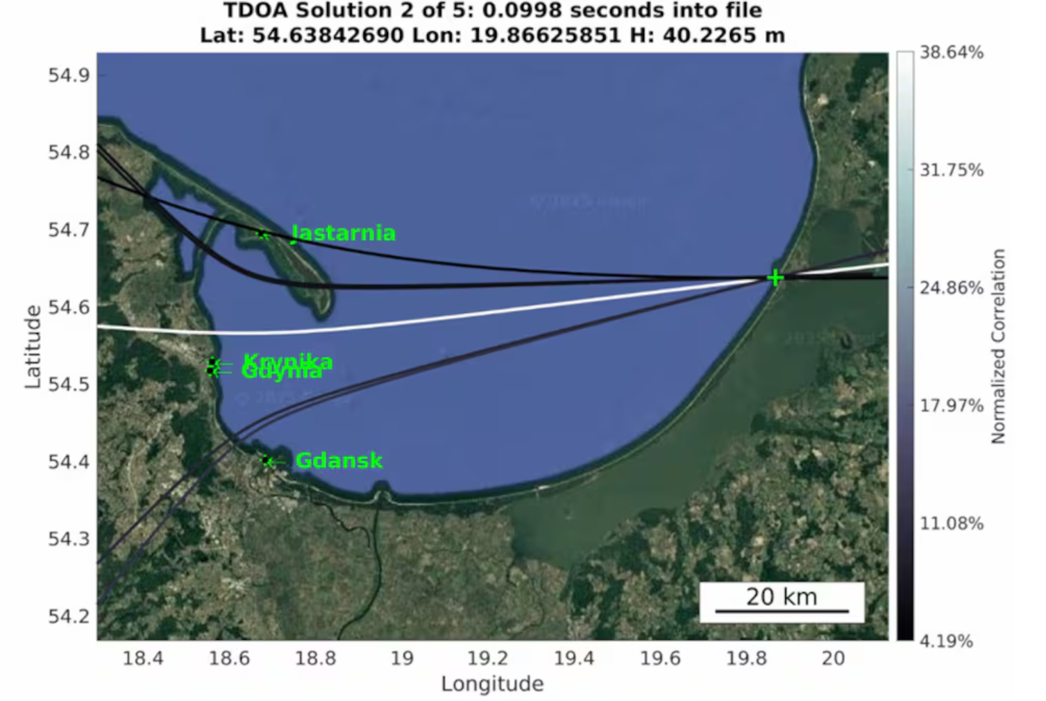
The report explores GNSS signal disruptions in the Baltic Sea and how it affects the safety of maritime and air traffic.
Scale and Methods of Russian Operations
Since the beginning of the full-scale invasion of Ukraine, Russia has intensified its hybrid activities against NATO member states, particularly those that have most actively supported Ukrainian resistance. This group includes the members of the Council of the Baltic Sea States. It is against them that the vast majority of acts of diversion and sabotage recorded in Europe since February 2022 have been directed.
Russia deploys a full spectrum of tools against the region:
Acts of diversion and sabotage targeting critical infrastructure.
Border incidents: Violations of airspace and maritime borders.
GNSS signal disruptions (satellite radio transmissions), creating operational problems for maritime and air navigation.
Cognitive influence, aimed at causing measurable damage, testing state responses, and inducing a sense of growing threat among societies.
Recommendations: How to Counter Hybrid Threats?
The offensive nature of Russian actions demonstrates an intent to destabilize NATO and EU countries. Effective defense requires developing shared mechanisms:
Close cooperation among agencies: Ensuring a high level of situational awareness through the coordination of activities (at both national and international levels) among military and civilian intelligence, counterintelligence, border guard services, and the police.
A dedicated information exchange system: Leveraging the geographical proximity and potential of the CBSS states to quickly share threat data.
Unambiguous attribution of persuasions: Publicly naming Russia as the author of the attacks. A lack of clear attribution hinders coordinated preventive and retaliatory measures.
A catalog of best practices: Developing common rules for monitoring, reporting, and responding to known and repetitive Russian operational patterns.
The authors conclude that only a full spectrum of coherent measures taken by all states in the region, alongside NATO and EU structures, can effectively influence Russia and reduce the risk of future incidents.
Radio waves emanating from secretive facilities run by Russia’s military are the culprit behind GNSS jamming in the Baltic Sea, according to Defense News.
The news outlet reports that Polish researchers collected jamming and spoofing information on incidents covering the Gdansk airport, shipping lanes, and the airspaces of Estonia and Finland. The interference has been recorded almost daily since Russia’s full-scale invasion of Ukraine in February 2022, resulting in flight cancellations, airport closures and commercial ships steering off track.
In March, eight European countries, including the Baltic states, Finland, Poland, France, the Netherlands and Ukraine, lodged a complaint with the UN about the practice. Several UN agencies have also taken up the issue, including the International Maritime Organization, the civil aviation authority ICAO and the International Telecommunications Union.
Russia, itself a Baltic Sea country, has not responded to the charges of interference. Likely origin spots include Kaliningrad, which is between Poland and Lithuania, and the St. Petersburg area. Both regions are known to have a heavy Russian military presence, including divisions specialized in electronic warfare.
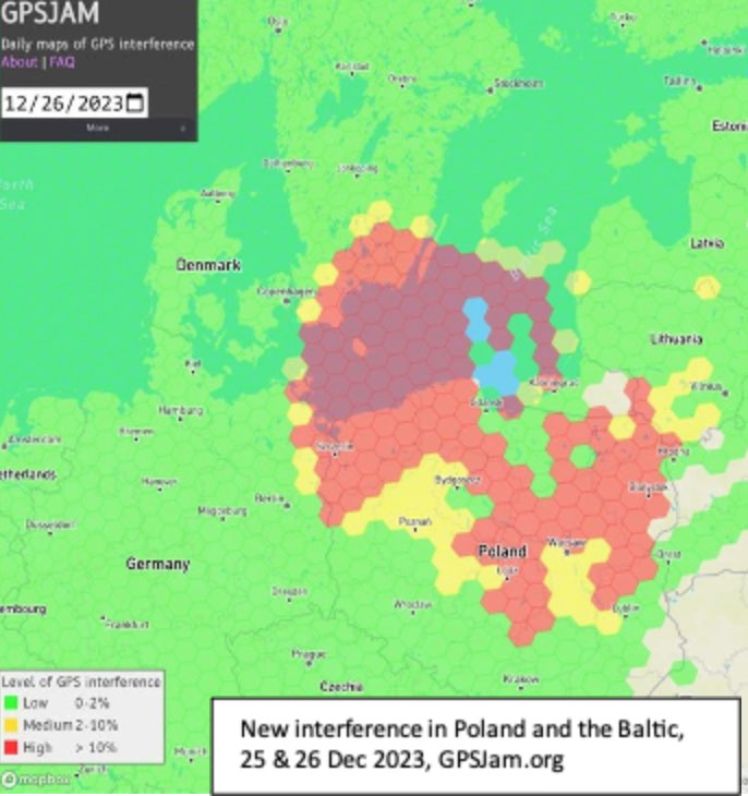
Parts of Poland, Lithuania, southern Sweden, and other countries in the Baltic region had an unexpected Christmas present this year. GPS signals were disrupted and not available in many areas on the 25th and 26th of December. Poland seemed to be particularly impacted, with the northern two-thirds of the country affected and many users on the ground and in the air having to make do without reliable service.
On New Year’s Eve, parts of Finland experienced significant jamming as well. The most visible impacts of the holiday events were seen in aviation and low navigation integrity reports from ADS-B systems. These were displayed on the GPSJam.org website.
Experts in the United States and Poland point to Russia as the source of the interference. They say that Russian anger over the activation of a U.S. anti-missile system in northern Poland in mid-December, and Sweden’s progress toward NATO membership with a recent positive vote in the Turkish Parliament were likely motivations.
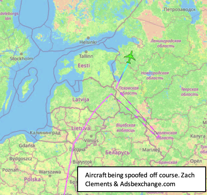
Such a reaction by Russia is not unprecedented. In 2022 President Putin threatened Finland and Sweden with invasion if they sought to join NATO. Subsequently, Finnish President Niinistö met with President Biden to discuss improving defense ties. Shortly thereafter planes flying over Kaliningrad and nearby areas in the Baltic began reporting GPS jamming. Analyses of the event by graduate students at the University of Texas Radionavigation Laboratory and Stanford University have provided some details and will likely reveal more as time goes by.
Zach Clements at U.T. studied the disruption and discovered that it included several transmitters spread across a wide area. Some were simply jamming GPS signals to deny service. At least one transmitter was spoofing aircraft so their instruments would show them far from their actual location.
While the phenomenon known as “circle spoofing” has been frequently observed with ships, this was the first time it was reported in aviation. With circle spoofing a receiver is electronically captured and “moved” to a different location. Then it is made to appear to move in circles, almost always in a clockwise direction
Image: Zach Clements/ GPSJam.org
Clements is reasonably sure the source of the circle spoofing was inside Russia. “The points at which the aircraft began to be impacted by the spoofing and where they regained authentic GPS indicate that the spoofer is somewhere in Western Russia. Interestingly, the location to which the aircraft were spoofed is a field about a kilometer from Russia’s decommissioned Smolensk military airbase.”
Zixi Liu at Stanford has discovered that the interference was actually two separate events. The first lasted from 9:30 PM on the 24th until 4:30 AM on the 25th, with the second beginning around 2:30 PM on the 25th and tapering off around midnight on the 26th.
Aviation interests have become increasingly concerned about interference with GPS signals since 2019 when a commercial passenger aircraft flying through smoke nearly impacted a mountain. Since then, aviation groups have raised the issue, national authorities have been regularly issuing warnings, and the UN’s International Civil Aviation Organization has urged its member nations to take action to prevent interference.
“Aviation is always at greater risk when GPS signals are not available or are compromised in some way,” according to Joe Burns, a senior captain at a major international air carrier. Burns is also a member of a board that advises the U.S. government on GPS and related issues. “Interference with GPS increases the risks of accidents and almost always slows the system down, makes flights longer, and more expensive,” he said.
The International Air Transport Association is meeting this month to discuss GPS interference. Most agree, though, that most meaningful short-term solutions will depend upon the cooperation of national governments across the globe.
Welcome to the geointelligence side of the Defense PNT and Geointelligence e-newsletter, a publication combining the staff, readership and subject matter of both its parents. We’ll alternate the two topic areas in this Insights column, while continuing to bring you news stories in every issue relevant to defense hardware, GPS/GNSS and PNT, and to the software and mapping side of the industry — geographic information systems (GIS) applied in defense, first responder and other government fields. That’s the geointelligence side, and I’m privileged this month to bring you the first column under that topic.
I’m Art Kalinski, GPS World’s and Geospatial Solutions’ contributing editor for Geointelligence. A career U.S. Navy officer, I established the Navy’s first GIS in the mid-1980s. I pioneered the use of oblique imagery for public safety and participated in numerous disaster-response actions including GIS/imagery support of the National Guard during Hurricane Katrina. I’ve worked for several companies in the imagery and mapping field.
Next month we’ll focus on a defense hardware GNSS topic. Now here I go on mine: how geography and mapping can correct the misperceptions of history and current public knowledge, and how GIS can support can be used in many areas including government policy and planning.
One authoritative, properly documented map can expose and possibly correct widespread public misinformation about America, its culture and its role in history. For instance, most entering college students think America invented slavery and that the U.S. was a dominant center of slavery.
Slavery can be considered a stain on our country’s history, but I believe this nation’s role in stopping it should also be a source of pride.
I was shocked, although I probably should have known better, by numerous citizen-in-the-street interviews (Watters’ World, Jimmy Kimmel, etc.) showing remarkably detailed knowledge people have about popular culture such as “Dancing with the Stars” or singers and movie stars who will have absolutely no effect on the lives of those being interviewed. However, those same people seem oblivious to science, finance and politics that could have a significant impact on their lives. Some of this appalling lack of knowledge derives from a lack of familiarity with history and in particular with geography.
One study, by Professor Duke Pesta of the University of Wisconsin, left me shaking my head. He found in his 11-year study that “Most entering college students think America invented slavery and that the U.S. was a dominant center of slavery.” Of course, Moses, the victims of the Romans, Genghis Khan, Alexander the Great, Vikings, not to mention Hitler, Stalin, Pol Pot, etc. would differ. Even at its height, the U.S. had less than 4 percent of the world slave population.
Here is a graphic depiction showing the volume and geography of the slave trade, 1600-1900. This is from an article by Harvard Professor Henry Louis Gates, Jr., host of the PBS series “Finding Your Roots” and author of numerous papers about slavery and ancestry. The map and the data driving it originated with The Trans-Atlantic Slave Trade Database, and both are the products of an international research and collaboration endeavor.
The project team worked with at least sixteen different data sets compiled by scholars working since the 1960s to collect archival data on slave-trading voyages from unpublished sources and to code them into a machine-readable format. The team developed sophisticated search interfaces for three different kinds of data, as well as estimates of the size and direction of the trade. Its web site provides a range of ancillary material for educators, including lesson plans and maps, and provides an opportunity for researchers everywhere to continue to contribute their discoveries.
Refer again to the map. It is truly a powerful document.
My History
Lest you think that I’m a disconnected observer of slavery let me share a little family history. I learned about slavery first-hand at my grandmother’s and uncle’s knee. They were both slaves.
In the early twenties, my grandparents immigrated to the U.S. They worked hard, saved their money, had two boys born in Chicago and then moved back to Poland, buying a farm and sawmill with their life savings. In 1938, on his 18th birthday, my father chose to move back to the “New Country” so as not to lose his U.S. citizenship. That was a lucky move, since in 1939 when Hitler invaded Poland from the West, Stalin seized the opportunity and invaded Poland from the East. Stalin, like Putin today, wanted the very fertile farmland that was a lacking in Russia.
(If you read my review of the geopolitical book The Accidental Superpower by Peter Zeihan, although large, Russia lacks adequate prime farmland and always coveted the very fertile region which is now Ukraine.)
When Russian troops invaded, my grandfather was executed in his own front yard and my grandmother and uncle were given 15 minutes to pack their belongings and board cattle cars for Siberia. As part of Stalin’s massive land grab, 1.7 million Poles and Ukrainians were deported in sub-zero freezing weather to work as slave labor in concentration camps.
Map from http://kresy-siberia.org
The speed of the invasion and deportations was so fast and unexpected that it was very disorienting. With dead bodies everywhere and only 15 minutes to gather possessions, many residents were in shock and not thinking clearly. One example: A woman who packed opera gloves and glasses. My grandmother understood the geography she would face and had the good sense to pack warm clothing and a large down comforter, a decision that saved her and my uncle.
Of the 1.7 million deported to the gulags, 100,000 died on the unheated train trips alone. Countless others died in the slave camps of Siberia, with less than 500,000 ultimately surviving. When the Russians, Brits and Americans became allies in 1942, my uncle was able to join the British Army and ultimately fought at Monte Casino and the Italian Campaigns. This photo shows the surviving members of his 60-man unit — my uncle, center front row.
I wish I had been old enough to learn and understand all the details of their ordeal, but much of it wasn’t fit for young ears. I did gain a visceral appreciation of the horrors of war, and slavery in particular.
The U.S. Civil War
Northeast Alabama, Huntsville and Lake Guntersville in particular, is where my wife and I chose to retire. Perfect balance of weather, scenery, quality of life and, most important, the people. We’ve made many good friends here, and a few can still tie themselves to direct descendants of the Civil War. Many, including my wife, still feel pride in the bravery their family members exhibited, just as I feel pride for the World War II military service of my U.S. Navy dad and three uncles.
According to historians, the South almost won the war had it not been for geography and the superior industrial base of the North. Additionally, those of you that have been in combat know that loyalty and personal bravery are seen at the unit level, and both American sides fought fiercely and bravely. Nationalism, philosophy and major political decisions are made at pay grades well above the unit level and are not in the forefront of a soldier’s mind during battle.
Map from http://lincolnmullen.com
There are some that claim that the Civil War was about states’ rights and not slavery. Ask John Brown and other abolitionists. Let’s be honest — the elephant in the states’ rights room was slavery. It pitted brother against brother. Even Ulysses S. Grant and Robert E. Lee were both classmates at West Point. Although on different sides, it took both sides to have the war, the bloodiest in our history. However, what both Union and Confederate troops created was an undeniable truth of American history and American exceptionalism.
To the best of my knowledge, this is the only country in the history of the world that fought a war with itself to free its own slaves.
Other countries have been conquered and slaves freed; in some, slaves revolted and freed themselves while other countries freed their slaves after seeing what the U.S. went through. But no other example matches the U.S. Civil War.
One benefit of having served as a career naval officer is that it exposed me to many parts of the world — Europe, Middle East, Asia, Africa, Latin America, the Caribbean — and not just tourist destinations. The United States still isn’t perfect, but in all my travels around the world, one observation is dominant about life on this geoid.
Whether you or your ancestors came here across the Bering Land Bridge, on the Mayflower, in the hold of a slave ship, through Ellis Island or on a 747, chances are pretty good that your life here is much much better than it would have been had your ancestors stayed where they were.
So, “Johnny,” America didn’t invent slavery, it wasn’t even the major slavery player. But we sure did put a stake in the ground to stop it, and we’ve been freeing people around the world ever since. Instead of pointing to our slave history with shame, we should instead point to the 500,000 casualties that started the path toward freedom. Are life and attitudes in the U.S. perfect? Absolutely not, but look at what we stopped, and look at what we are perfecting.
Lockheed Martin and the Warsaw University of Technology (WUT) successfully demonstrated their UAV optimization technologies using aerial command and control (C2) of multiple unmanned aerial vehicles (UAVs).
The demonstration marks a successful milestone in the joint WUT-Lockheed Martin advanced applied research program on optimization of diverse fleets of aircraft, and concepts associated with manned-unmanned command and control of airborne platform systems.
“These technologies have tremendous commercial and military potential as the world moves toward greater and greater use of unmanned aerial systems,” said Prof. Janusz Narkiewicz, head of WUT’s Department of Automation and Aeronautical Systems. “Understanding how different assets can interoperate, communicate and serve common objectives with maximum efficiency is a challenging task in the growing field of UAV technologies.”
Through the use of advanced mathematic calculations and a systems-of-systems approach, the technology bolsters mission efficiency by adapting the fleet’s commanded flight paths, speeds, division of duties and sensor performance. Modeling all the constraints of the task at hand, the students calculate the “best answer,” usually beating either the human best guess or simpler approaches by 10 to 20 percent.
The goal of the team’s latest project was to advance previous optimization work by incorporating airborne C2, improving user interfaces, and testing new methods for related subroutines. With a vision of ultimately developing fast dynamically adaptive approaches to live management of a UAV fleet, this work is an important contribution to the concept of manned-unmanned teaming, where manned assets operate seamlessly with surrogate UAVs, often controlling many at a time against specific tasks.
The technology demonstrates that, with the right tools, an operator may adapt to changing scenarios, calculate new solutions, and deploy those new, optimized solutions to the fleet of commanded aircraft, whether for civil or military purposes, a Lockheed Martin news release said.
The recent demonstration can be equated to a search-and-rescue task, where every minute shaved off of a search pattern could be the difference between life and death.
In another example, if UAVs were to be used to deliver small packages to consumers, the 10 to 20 percent performance improvement could be the competitive edge that keeps an operation in business ahead of the competition.
The program builds on the strong industrial and academic partnership between Poland and Lockheed Martin aimed at motivating young Polish engineers to address tomorrow’s defense and industrial needs. WUT and Lockheed Martin are seeking new Polish partners to further advance Polish research and development capabilities on manned-unmanned airborne platform system integration.
CE-Traffic, a traffic data provider in Central-Eastern Europe, has extended its portfolio of traffic services in Poland, the country where over last five years the number of vehicles has grown by 50 percent. Drivers in Poland can look forward to more options in receiving real-time traffic information with the launch of the new Premium RDS-TMC service by CE-Traffic, the company said.
“We looked at TMC solution with all its limitations and asked ourselves: how we can get more out of the technology that has been around for more than a decade so that navigation systems vendors can offer to their customers an easy-to-implement and affordable traffic service of a real value? Our Premium RDS- TMC offers drivers an access to very detailed traffic information without any mobile telecommunication cost and subscription fees,” said Jiri Novobilsky, CEO of CE-Traffic.
Competitive advantage of CE-Traffic Premium RDS-TMC is based on smart use of TMC components, according to CE-Traffic. Up-to-date traffic flow data and journalistic information are smartly aggregated and regionally filtered. CE- Traffic TISA certified Location Table (LTN 6) offers the best available coverage. It includes not only all major roads and streets but also lower category roads commonly used by drivers like shortcuts or alternative routes. RDS channel with enhanced capacity allows broadcasting high number of traffic messages (over 1,000). The service is available country-wide thanks to partnership with Radio ZET – leading Polish radio station.
Tomasz Przeździęk, CE-Traffic director for Poland, added: “When looking at overall traffic offering for personal and in-car navigation systems in Poland one can see that expensive connected devices did not achieve the major market acceptance. Proven TMC standard together with high quality CE-Traffic Floating Car Data is an easy to implement alternative to provide drivers with the most accurate and up-to-date traffic information.”