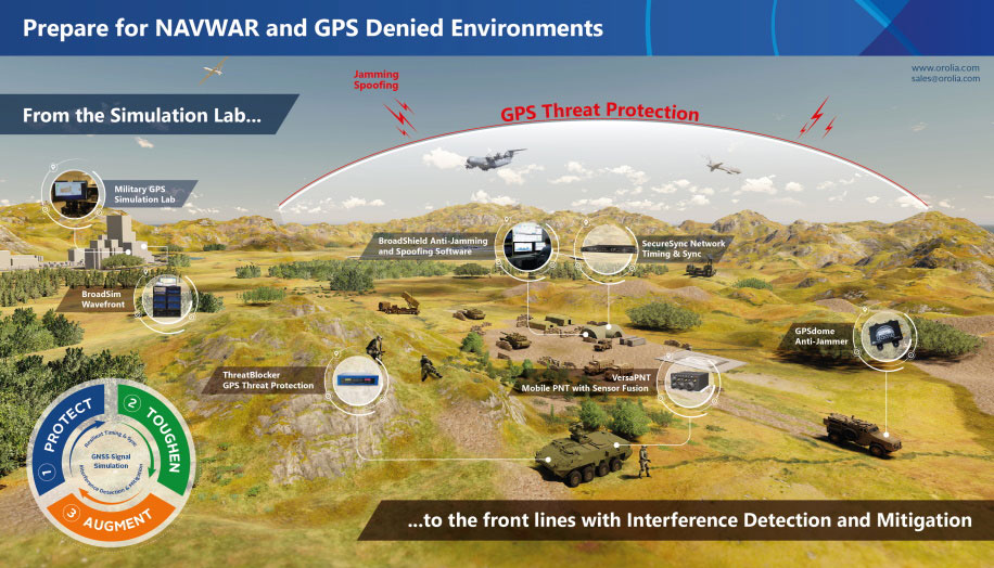
Resilient positioning, navigation and timing (PNT) company Orolia has nearly tripled new U.S. military orders for specialized resilient PNT solutions in the third quarter of 2019, the company stated in a press release.
Orolia said its solutions are helping to meet growing military demand for assured operations in Navigation Warfare (NAVWAR) and GPS-denied environments.
In the third quarter, Orolia unveiled its new Simulation and Interference, Detection & Mitigation (IDM) suite, announced the acquisition of GNSS simulation company Talen-X and introduced new advanced GNSS jamming and spoofing countermeasures.
The new U.S. military orders include the full range of Orolia’s resilient PNT solutions.
“This rapid industry response affirms Orolia’s commitment to delivering trusted military solutions for GPS denied environments,” said Paul Zweers, Orolia vice president of sales and marketing.
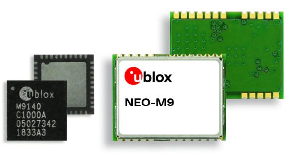
The ultra-robust M9 technology platform will suit demanding automotive and high-end telematics.
U-blox, a global provider of positioning and wireless communication technologies, has launched its new ultra-robust meter-level M9 global positioning technology platform, designed for demanding automotive, telematics and UAV applications.
Because of the high-performance GNSS UBX-M9140 chip, the M9 technology platform and the NEO-M9N (the first module based on the platform) can receive signals from up to four GNSS constellations (GPS, GLONASS, Beidou and Galileo) concurrently. It can achieve high positional accuracy even in difficult conditions such as deep urban canyons, u-blox said in a press release.
The u-blox M9 offers a position update rate of up to 25 Hz, enabling dynamic applications like UAVs to receive position information with low latency. It also features special filtering against RF interference and jamming, spoofing detection and advanced detection algorithms that enable it to report fraudulent attacks quickly so that users’ systems can react to them in a timely fashion.
A SAW (surface acoustic wave) filter combined with an LNA (low noise amplifier) in the RF path is integrated in the NEO-M9N module. This setup guarantees normal operations even under strong RF interferences, such as when a cellular modem is co-located with the NEO-M9N.
“We’ve developed the u-blox M9 as a follow-on from our very successful u-blox M8 GNSS platform, offering even more robust meter-level positioning technology and security features to protect the integrity of applications in the automotive, telematics, and UAV markets,” said Bernd Heidtmann, product manager, Product Strategy GNSS, Product Center Positioning, at u-blox.
Users of the u-blox M9 will benefit from it being part of the wider u-blox product family, which means that developers will be able to design a single PCB and then migrate to a different positioning technology — such as dead-reckoning augmenting GNSS technology — with little change to the board design.
Explorer kit released
U-blox has also released the Explorer Kit M9 (XPLR-M9), a development board for designers who want to assess the technology. The miniature plug-and-play device is supplied with user-friendly u-start software, which includes preset scenarios to enable users to explore the performance of the new device.
The u-blox M9 technology platform complies with the ISO/TS 16949, ISO 16750, AEC-Q100 standards. Engineering samples of the NEO-M9N, the first module based on the M9 platform, the UBX-M9140 high-performance chip, and the Explorer Kit are available now.
To learn more about M9, visit the u-blox booth, Hall South, S.2702, at Mobile World Congress 2019 in Los Angeles, Oct. 22-24.
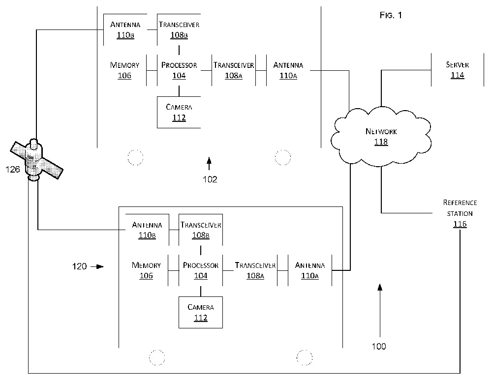
Tesla has developed a technology aimed at providing more accurate positioning for autonomous cars by sharing data between vehicles, according to a U.S. patent application.
The patent, “Technologies for vehicle positioning,” was filed in 2017 and made public in December 2018.
Solutions include cameras detecting matching locations and using other vehicles in its fleet as “cooperative reference stations” to share raw GNSS data and make positioning corrections.
Tesla describes in the patent, “The inventions increase such positioning accuracy via determining and applying offsets (corrections) in various ways, or via sharing of raw positioning data between a plurality of devices, where at least one knows its location sufficiently accurately, for use in differential algorithms.”
Techniques include:
a reference station sharing a positional offset with an automobile,
a reference station calculating and sharing a set of parameters (offsets and corrections) for various error components including atmospheric, orbital and clock,
a reference station sharing its raw GNSS data so that vehicles can remove errors through differencing or other calculations.
Tesla also would correct GPS data by matching camera data with vision maps to detect the exact location of a vehicle. With this vision-map matching localization approach, “a location estimate is varied until the location estimate makes a camera-reported lane boundary coincide with a map-reported lane boundaries,” the patent reads.
Schematic of Tesla’s system shows two vehicles (102, 120) feeding data to a network, a server and a reference station. (Image: Tesla)
The U.S. Army is drafting new rules for the use of GPS receivers in weapon systems to combat spoofing and jamming attacks, as well as signal loss in GPS-denied environments, according to news reports.
The six- to seven-page capabilities requirements document is awaiting a signature from Army leadership, according to Willie Nelson, director of the assured PNT (positioning, navigation and timing) cross-functional team. Nelson spoke to reporters Oct. 9 at the Association of the U.S. Army annual meeting in Washington, D.C.
The Army has been trying for years to complete a GPS requirements document, a “system of systems architecture for assured PNT.” But with virtually every device equipped with GPS, the document would have been too big and too broad, Nelson said.
(Photo: U.S. Army)
The approach now is for separate sets of requirements: one for mounted equipment (now complete and awaiting the signature), a dismounted requirement, and situational awareness.
The difficulty facing the Army is the plethora of PNT systems in use. For instance, an armored personnel carrier may have five to seven unconnected GPS receivers, some with encryption, some without. The weakest receiver could negatively affect the vehicle, Nelson said.
With the new requirements, Army vehicles will have a consolidated, networked, software-based PNT solution. Dismounted receivers used by soldiers will have similar requirements.
Industry will be asked for specific solutions within each of the PNT sectors rather than an “all of the above” solution.
The Army is also expected to create a training program for soldiers that operate PNT systems.
Signals other than GNSS are the key to positioning for both the transportation and machine control markets. While many solutions are being developed, inertial navigation systems (INS) are emerging as the primary GNSS co-star.
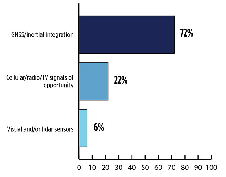
In our survey, nearly three quarters (72%) of respondents in this sector said positioning could best rely on tight integration between GNSS and INS. For comparison, inertial technology wasn’t even mentioned in the 2017 State of the GNSS Industry Report. This year for the first time, GPS World offered an Inertial Buyers Guide for our readers (see our May issue).
What is the best additional solution for positioning in GPS/GNSS-challenged environments? (Source: GPS World 2018 State of the GNSS Industry survey)
Practical autonomous navigation — the current ambition of automakers (and Google) — hits a roadblock when it comes to uninterrupted positioning. We all know GNSS reception has its limits, notably in many places that vehicles travel such as tunnels, beside tall buildings and in parking garages. Inertial positioning fills that gap, making it especially advantageous for meeting the challenges of autonomous navigation.
Inertial measurement units are generally based on multi-axis combinations of precision gyroscopes, accelerometers and magnetometers using algorithms to determine location, direction and position. Gyroscopes measure the angular velocity; accelerometers measure overall acceleration; and magnetometers provide the direction of the magnetic field.
Micro-electro-mechanical (MEMS) techniques have reduced the size, power consumption and costs of INS systems considerably, enabling their use in ever more applications, including unmanned aerial vehicles.
As a result, products that combine GNSS + INS are being introduced at an increasing rate, with more than a dozen major announcements in the past year. According to one study, the INS market is projected to grow from US$11.89 billion in 2017 to US$19.67 billion by 2023, a compound annual growth rate of 8.76%.
For more results from the 2018 State of the GNSS Industry, see this page.
Presentations from the 20th meeting of the National Space-Based Positioning, Navigation, and Timing Advisory Board (PNTAB), held Nov. 15-16, are now available online at GPS.gov.
Ligado and its predecessors have sought to install high-powered ground transmitters that have been shown to harm and overwhelm GPS signals and receivers in their general vicinity. The controversy has simmered for at least eight years without resolution.
PNTAB provides independent advice to the U.S. government on GPS-related policy, planning, program management, and funding profiles in relation to the current state of national and international satellite navigation services.
GeoCue Group has released a GNSS positioning system that will allow users of DJI Phantom 4 Pros and Inspire 2 drones, as well as most drones using higher end cameras, to achieve survey-level accuracy with minimum ground control.
Loki, GeoCue’s new direct geopositioning system for small unmanned aerial systems, solves the two fundamental problems associated with this technology:
Positioning Accuracy. Loki uses the new AsteRx-m2 multi-frequency, multi-constellation GNSS engine from Septentrio, which has 448 hardware channels.
Camera Events. GeoCue has invented a patent-pending method of detecting camera events from Phantoms/Inspires and synchronizing those events to GNSS positioning. No modifications to the drone are necessary; the adapter cable is “plug and play.”
GeoCue’s Loki positioning kit uses the Septentrio AsteRx-m2 GNSS engine.
Loki is a self-contained kit that provides all of the hardware and software needed to equip a drone with a post-processed kinematic (PPK) multifrequency, multi-constellation, differential, carrier-phase GNSS.
Using a local base station (not included), Loki provides centimeter-level positioning with minimal, and in some cases, no ground-control points (though GCPs are always recommended for quality assurance).
“GeoCue has been a long-time Septentrio OEM development partner,” said Neil Vancans, vice president of Septentrio Americas. “They have offered our previous generation sUAS board on their high-end AV-900, achieving remarkable results in both accuracy and reliability. By solving the problem of connecting the virtual camera trigger on DJI drones to our AsteRx-m2 GNSS engine, they can achieve professional mapping accuracies with consumer-grade UAVs.”
DroneDeploy of San Francisco has become a leader in cloud-based processing for DJI, as well as other drones. DroneDeploy has enabled users of Phantom and Inspire drones to easily upload drone images, work online with analytics, and download point clouds and orthophotos to desktops for advanced processing.
Without Loki, achieving acceptable network accuracy requires the time-consuming placement of ground-control targets throughout the mapping site.
GeoCue and DroneDeploy have been working together to ensure a smooth Loki-DroneDeploy workflow from field to finish.
“The GeoCue Loki system is an exciting product for anyone using drones to make maps with high accuracy,” said Mike Winn, CEO and co-founder of DroneDeploy. “The Loki’s combination of high-end GNSS positioning and DJI camera synchronization enables survey-grade accuracy with the simplest workflow that we’ve seen — making the Loki a great fit for the DroneDeploy platform.”
“I am very excited to be working with industry leaders such as DroneDeploy on our Loki project,” said Lewis Graham, president and CTO of GeoCue Group. “Loki provides high accuracy positional data to downstream processing solutions. More significantly, it does this for DJI Phantom 4 Pro and Inspire 2 drones. Combining DJI, Loki and cloud processing solutions such as DroneDeploy provides a very streamlined and cost effective solution for high accuracy site surveys.”
The Loki kit includes:
Loki PPK Controller using the Septentrio AsteRx-m2 GNSS engine (GPS L1, L2, L5 and GLONASS L1, L2, L3, 448 hardware channels).
Maxtena M1227HCT-A2-SMA high performance, active, multiband GNSS antenna
Antenna ground plane with mounting kit
Antenna to controller cable
USB cable for data transfer and Loki controller charging
Personality cable (user selects either DJI or DSLR)
AirGon ASP software suite
Mounting kits for DJI Inspire 2 and Phantom 4 Pro
1 year of maintenance and technical support
Loki requires a local multifrequency base station (not included but available from GeoCue). Loki is shipping to early adopter customers in August 2017. It will be available for the general market in September 2017.
It will release with direct support for DroneDeploy and AirGon’s Bring Your Own Drone (BYOD) Mapping Kit. Loki’s introductory price will be USD $4,995. GeoCue is currently accepting preorders.
Loki will be on display September 6-8 at the InterDrone 2017 conference in Las Vegas and at Commercial UAV Expo, also in Las Vegas, October 24-26. A workshop dedicated to high accuracy mapping with DJI drones using Loki is being held in conjunction with the Commercial UAV Expo. Register at www.expouav.com.
Comtech Telecommunications Corp. has launched Location Studio, a versatile service platform for mobile operators, application developers and enterprises to build or enhance cloud-based, embedded and hybrid applications using a modular set of location-based services (LBS) tools.
Location Studio incorporates multiple technology suites that provide a broad range of functionality, allowing developers to create location enabled applications with contextual awareness, including:
GeoSuite for integration of maps, search, geocoding, routing and navigation. Also includes geofencing for triggering alerts when devices enter or exit a specified space, and Comtech’s Trusted Location solution for verifying and validating a device’s location to prevent fraudulent activity.
PositioningSuite, a powerful engine that can locate and track assets, such as IoT devices, seamlessly switching between inside and outside environments while minimizing device power consumption using a proprietary geofence algorithm that eliminates the need for “always on” GPS.
MessagingSuite, a comprehensive, carrier-grade messaging platform that supports virtually all messaging protocols and is capable of supporting personalized high-volume messaging applications for alerts and notifications, such as product and/or services information, emergency alerts, and critical internal communication.
AnalyticsSuite, a web-based portal for reviewing and exploring user, device or application data.
“Location Studio encompasses two decades of location-based services experience that can be easily configured into consumer, industrial or workforce-ready applications and services while minimizing deployment timelines, costs, and resource requirements,” said Jay Whitehurst, president of Enterprise Technologies, Comtech Telecommunications Corp. and member of CTIA’s Board of Directors. “We are excited to see how this new platform influences and enables the use and impact of location intelligence across a number of different markets.”
Location Studio supports both hosted and in-network LBS solutions and provides API’s that can be tailored to meet the specific needs of various vertical market customers, including mobile network operators, automotive OEMs, fleet and logistic organizations, insurance and financial organizations, as well as manufacturers. As part of these solution offerings, Comtech provides project management, coordination and testing support.
Editor’s Note: Comtech placed third in the IoT category for 10th annual CTIA Emerging Technology Award at CTIA Super Mobility 2016. According to the wireless association, the winners represent the latest innovation in mobile products and services that have the power to transform networks, businesses, smart cities and connected consumers. Newell Thompson, vice president, Category Marketing, Technology & Telecommunications, Time Inc. presented the winners at the live awards ceremony at the Sands Expo.
“CTIA Emerging Technology Award winners represent the best mobile products, apps and services of the year that have the potential to influence and benefit businesses and consumers,” said CTIA Show Director and Conventions AVP Heather Lee. “Marking the tenth year of this distinguished awards program, CTIA is honored to once again recognize companies that are raising the bar of excellence for mobile innovation.”
A panel of 35 industry experts and analysts judged submissions across 15 award categories to determine the finalists and winners. The “Crowd Favorite” was determined by a popular vote of CTIA Super Mobility 2016 attendees and online visitors.
Everyone talks about the weather, but nobody does anything about it — right?
Our lead authors this month are doing something about it.
The July cover story of GPS World magazine was titled “See into the Smoke with Inertial.” This month’s feature could have been called “See into the Fog with CDGNSS,” but we just didn’t have room in the already extensive article to go into that angle. So here it is.
Precise carrier-phase differential GNSS positioning will in the near future become a must-have complement to cameras and lidar for all-weather automated driving. Positioning will be furnished, as the article explains, by a dense reference network broadcasting to low-cost antennas for precise (10 centimeter) performance.
Here’s the kicker, not included in your cover-story package, although hinted at by the orange and green trapezoids on the cover, and replicated in the fog-bound version above.
Such vehicle positioning would enable new driver-assistance systems. With precise knowledge of a vehicle’s position and orientation, intuitive driving directions can be rendered on the windshield in luminous paths that appear to be painted on the roadway. These paths will guide the driver along the fastest route to destination. Other symbols will suggest lane changes for safety or efficiency, and highlight the presence of vehicles dangerously close ahead. Because satellite navigation signals are not affected by rain, snow or fog, they can be combined with radar sensors to safely guide a driver or an automated vehicle in all weather.
As author Todd Humphreys explains it, “Imagine how relaxing it would be to follow a yellow brick road safely home! I envisioned this augmented-reality heads-up display during a recent road trip. Driving on unfamiliar roads, I was trying to interpret various route options on my wife’s smartphone while simultaneously fielding questions (in Spanish!) from my in-laws, and more questions from my nine-year old son. It was too much to ask of one driver!”
Not any more. That is, soon, in our brave new future, no longer.
A four-satellite dispenser for Galileo’s Ariane 5 is shown during shaker testing at Airbus Defence and Space near Bordeaux, France. The dispenser has had four Galileo engineering models attached to it for test purposes. (Photo: ESA)
In Geospatial Solutions’ sister publication, GPS World magazine, I’ve written quite a bit about how high-precision GNSS is going to significantly improve over the next few years.
Most GNSS users have receivers capable of using GPS (31 satellites) and Glonass (about 24 satellites). That generally equates to between 13 and 20 satellites in view with a clear sky and average terrain. However, add in variable terrain, some trees and perhaps a nearby building or two, and it can be a challenge to find enough solid satellites to track to obtain a high-precision GNSS position (less than a meter).
As the demand for high-precision GNSS positioning continues to grow, users are going to want to work in increasingly more difficult environments where high-precision GNSS struggles. More satellites will help, but they won’t come from GPS, nor GLONASS.
The GPS constellation is currently full, and is not going to grow any larger than 31 satellites (due to limitation in current GPS ground control software) in the foreseeable future. Even if GPS could fly more satellites, the orbit design accommodates only 27 satellites. GLONASS appears happy at 24 satellites and is not expanding anytime soon.
The answer lies in Europe, with China following.
After two decades of start, stop, restart, retool, regroup and start again, Europe’s Galileo constellation is real — very real. It’s all fun and games until Galileo starts launching four satellites at a time, which it is scheduled to start doing in a couple of months. Those four new satellites, added to the 12 in orbit (plus two in odd orbits), should be enough for Galileo to begin initial operation in Q4 of this year. Then, each new launch of four additional Galileo satellites will only improve the reliability and robustness of high-precision positioning. That’s a big deal for high-precision GNSS users.
Get ready for another jump in performance in high-precision GNSS positioning.
Do you remember the value that GLONASS added to GPS-only receivers 10-plus years ago? It was a premium feature on high-precision GNSS receivers in those days. Now, GLONASS is a standard feature on your smartphone.
Not very long from now, we’ll be making similar comments about Galileo. Satellite positioning in general, and high-precision GNSS positioning specifically, are satellite-hungry. As high-precision GNSS technology continues to embed itself deeper into a wide variety of industries, users will expect the technology to work. Some of those expectations, maybe many expectations, will be unreasonable. In dense urban environments? Under heavy tree canopy? In rugged terrain?
Unreasonable expectations are O.K. — that’s what pushes GNSS product managers and GNSS engineers to think outside of the box. More satellites will help meet some of the unreasonable user expectations.
What’s even better is that China’s global BeiDou system isn’t far behind Galileo. China’s regional BeiDou system (16 satellites in regional orbits over China) already makes China the best place in the world for high-precision GNSS positioning. Like Galileo, China’s global constellation is said to consist of 30 satellites.
That means in the not-too-distant future (about 2018 for Galileo and 2020 for BeiDou):
31 x GPS
24 x GLONASS
30 x Galileo 30 x BeiDou Total: 115
This translates into more than double the satellites in view that we have at this point in time. But, you don’t have to wait. Galileo satellites are usable this year if your receiver has been designed to use them. With each new Galileo launch, you’ll have access to four more satellites until the constellation reaches 30. The same goes for BeiDou.
Don’t take this wrong, GPS isn’t done. Not by a long shot. However, historically speaking, at one satellite per rocket launch, it’s only averaging about one launch every six months. To complicate things, the U.S. Air Force has launched all of the current GPS model (IIF) satellites and aren’t ready to launch GPS III satellites yet. See Don Jewell’s August column in GPS World magazine for details.
The good news is that the user community doesn’t have to rely on an expanded GPS constellation to improve performance any more than the “gold standard” it has become. The difference-makers are going to be Galileo beginning this year and BeiDou beginning in 2018. So, get ready folks, and fasten your seatbelt. The next generation of GNSS is about ready to begin, and your geodatabase is about ready to get a double-shot of Vitamin B.
Sponsored by:NavCom Broadcast date: Thursday, March 19, 2015 Moderator: Alan Cameron, Group Publisher, GPS World and Geospatial Solutions Speakers: Mark Wilson, Vice President, Sales, IFEN Inc.; Neal Fedora, Director, Engineering, Spirent Federal Systems Inc.; Julian Thomas, Founder, Racelogic; Darren Fisher, GNSS Market Manager, Spectracom Summary: More signals (e.g., GPS + Galileo + BDS) and special techniques that are well-adapted to mobile users (gentle antenna motion, use of cameras) allow one to get away with using less expensive antennas and yet still resolve the ambiguities needed for centimeter-accurate positioning.
TerraGo is partnering with Positioning Solutions International (PSI), a provider of high-accuracy positioning solutions for infrastructure, land management, agriculture and related industries.
PSI is an authorized reseller of TerraGo Edge software and offers a full range of turnkey systems and services that combine mobile data-collection software from TerraGo with high-accuracy GNSS receivers from CHC Navigation.
“What’s great about TerraGo Edge is that it’s designed to be customized out of the box, so we can give our customers and dealers a mobile solution tailored to their specific industry and unique workflow requirements,” said Charlie Towne, president, Positioning Solutions International. “And because it integrates seamlessly with the line of CHC receivers, we can provide any level of accuracy the job requires, even real-time centimeter RTK, directly on a smartphone or tablet.”
“The PSI team has decades of experience deploying high-accuracy positioning technology to meet the most demanding customer requirements, and they understand how to help organizations use BYOD solutions to seamlessly replace legacy, proprietary technology,” said John Timar, vice president, Worldwide Sales, TerraGo. “They bring the industry experience and subject matter expertise to our projects that guarantee successful outcomes for our mutual customers using TerraGo Edge, so they can improve accuracy while realizing tremendous cost savings and improving efficiency with a modern, mobile solution.”
PSI provides solutions to customers and a network of value-added dealers, and is the exclusive southeastern regional territory distributor for the CHC Navigation brand of GPS/GNSS products and network solutions.