Tag: public safety

  • Viavi launches ePRTC360+ clock alternative to Cesium-accuracy holdover clock

    Viavi launches ePRTC360+ clock alternative to Cesium-accuracy holdover clock

     Viavi Solutions Inc. has launched the patent-pending Cesium-less ePRTC360+ holdover solution to safeguard at-risk critical power grids, transportation, aviation and public safety systems, 5G mobile networks and AI data center infrastructure against the increased threat of GNSS timing disruptions. It is the only alternative to Cesium clocks to meet ITU-T G.8272.1 standards.

    The international ITU-T G.8272.1 standard stipulates that Enhanced Primary Reference Time Clock (ePRTC) holdover must have short-term drift of less than 30 ns when entering into holdover and a long-term drift of less than 100 ns over 14 days, all traceable to UTC. Previously achieved only by Cesium atomic clocks, VIAVI’s ePRTC360+ now also meets this standard.

    ePRTC360+ Enhanced Primary Reference Time Clock

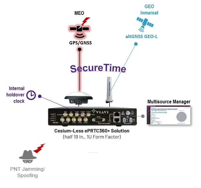
    The ePRTC360+ has been successfully tested across a range of live-sky defense and commercial jamming/spoofing environments, and has been integrated into VIAVI’s SecurePNT 6200 product series. The technology can maintain 100 ns accuracy during GNSS-denied threats through the resilient altGNSS GEO-L service with no time limit.

    It also combines an augmented VIAVI SecureTime GEO anti-jamming antenna and an enhanced GNSS anti-spoofing antenna that also receive eGNSS GEO service with GPS/GNSS-NMA authentication for spoofing detection and mitigation.

    Unlike conventional GNSS omni-directional signals, which can be drowned out by low-power interference, VIAVI’s GNSS-independent GEO-L service leverages encrypted and highly directional L-band signals transmitted from geostationary satellites. Coupled with the augmented VIAVI SecureTime GEO antenna, the altGNSS GEO-L service provides enhanced anti-jamming protection and a resilient timing reference for the ePRTC360+’s internal Rubidium holdover oscillator and enables smooth multi-orbit source switchover, even when primary GNSS frequencies are jammed, spoofed or subject to sophisticated meaconing attacks.

    The affordability of ePRTC360+ clocks compared to Cesium clocks enable operators to deploy them beyond the core and across the network. They also complement non-RF Cesium clocks at the core. This boosts end-to-end sync network robustness and holdover reliability through meshed network PTP feeds as backup between the clocks, especially in case of local or regional jamming and/or spoofing threats.

    In addition, the ePRTC360+ addresses constraints posed by the use of Cesium clocks for holdover timing. These include sensitivity to shock, delicate and multi-stage startup procedures that take days to complete, the need for ECCN 3A001.i licenses for export, long GNSS learning period of up to 40 days, as well as strict shipping and storage protocols. In addition, Cesium tubes need to be replaced approximately every seven years, and the dismantling and disposal of Cesium clocks are classified as a hazard due to their material content.

    The ePRTC360+ eliminates these hurdles and has been designed for rapid and easy integration into any vendor’s grandmaster clock system. It enables operators to meet stringent ePRTC requirements while reducing total cost of ownership.

    The ePRTC360+ will be demonstrated at VIAVI’s Stand 5B18 at Mobile World Congress (MWC) Barcelona 2026, March 2-5, in Barcelona, Spain. 

  • European PAVE-SCAN project aims to increase transport efficiency, safety

    European PAVE-SCAN project aims to increase transport efficiency, safety

    The European Union PAVE-SCAN project aims to build European GNSS-based and AI-driven technologies to detect and assess roadway pavement problems.

    The proposed project aims for the development to market (TRL8-9) of European GNSS-based integrated low-cost sensor technologies and artificial-intelligence-driven open-architecture software solution — machine learning (ML) and machine vision (MV) — for the detection, classification and georeferencing of roadway pavement surface anomalies, and for the low-cost assessment of roadway pavements using participatory sensing.

    The proposed system is of practical importance because it provides continuous information about roadway pavement surface anomalies — valuable for efficiently monitoring the transport infrastructure and for public safety. The vision for roadway condition assessment using smartphone-like technology is under the hypothesis that such technology can be used for crowd-sourced data collection and analysis in GIS-based pavement management systems (PMS).

    “The developed technology and related transport informatics are disruptive technologies that have the potential to reshape the transport and infrastructure industries,” according to the project description.

    The project is funded under Horizon Europe; with the University of Cyprus Department of Civil and Environmental Engineering serving as a partner.

    The project’s objectives are outlined below.

    Table 1. Project objectives
    #Project ObjectiveWP
    1Near-real-time analysis and classification of roadway anomaliesWP3,WP4,WP5
    2Geospatial mapping of transport infrastructure, roadway anomalies and condition-assessment heatmapsWP3,WP4,WP5
    3Geospatial mapping of transport infrastructure, roadway anomalies and condition-assessment heatmapsWP3,WP4,WP5
    4Improved roadway management practices, prioritisation of public works & lower costsWP4
    5Reduction in the transport-related environmental footprint through improved O&M of transport infrastructure and of mass transitWP4,WP6,WP7
    6Reduction in roadway-assessment costs by utilization of a fleet of vehicles/buses as participatory sensorsWP5,WP6,WP7
    7Integration with national transport initiatives (e.g., National Single Access Point), & with Digital Twin platforms, for dynamically updated roadway-condition models, and improvements in transport safety through roadway improvementsWP4, WP5
    8Open-access data and APIsWP1, WP8
    9Product to market and ‘Product as a Service’ (PaaS) business modelWP8
    10Dissemination of project resultsWP1
  • Self-driving cars: Innovative or a nuisance?

    Self-driving cars: Innovative or a nuisance?

    Photo:
    Image: iStock/Getty Images Plus/Getty Images

    San Francisco local officials are questioning the safety of autonomous vehicles (AV), also known as self-driving cars, due to frequent reports of traffic violations, delaying public transportation and emergency vehicles, causing traffic congestion as well as driving onto public sidewalks.

    California officials granted the first AV deployment permits this year, allowing companies to release self-driving cars onto city streets and to provide passenger service as robotaxis. Since granting permits to AV companies such as Waymo and Cruise, self-driving vehicles have been creating a multitude of issues with public safety, including a recent incident of a Cruise AV stopping a bus on its route for over seven minutes.

    As state governments have the legal power to grant permits to AV companies to conduct testing and ride hail services, city officials are left powerless to control self-driving car incidents that affect residents and public safety. City officials also struggle to obtain information regarding AV-induced road blockages and even a comprehensive list of all companies have deployed self-driving vehicles onto their roads.

  • WingXpand’s expandable-wing drone stretches to 7 feet

    WingXpand’s expandable-wing drone stretches to 7 feet

    Photo: WingXpand
    Photo: WingXpand

    WingXpand has debuted a 7-foot expandable-wing drone that fits in a backpack. The drone was first revealed to the special forces community at the Special Operations Forces Industry Conference (SOFIC 2022) held May 16-19 in Tampa, Florida.

    WingXpand is U.S. made with a patented design that takes the small size and simplicity of a quadcopter and combines it with the horsepower of an airplane. WingXpand maximizes capability, efficiency and safety for the military and public safety officials. It can also be used  by farmers, surveyors and inspectors.

    WingXpand expands in less than 2 minutes. Though the full system weighs less than 10 pounds, it flies five times longer and carries ten times more weight than other drones of its size class, according to WingXpand. It can carry high-resolution cameras and other modular payloads such as a real-time pattern analysis system.

    WingXpand can reduce or replace the need for more costly, scarce or dangerous options. More than 10 WingXpand UAS can fit in a public safety vehicle, more than 30 in a pickup, and 250 on a standard airlift pallet.

    The WingXpand team provides end-to-end services, including pilot services, training, data analysis and sustainment.

  • NextNav to deliver high-precision vertical location for 911

    NextNav to deliver high-precision vertical location for 911

    NextNav’s Pinnacle 911 will deliver Z-axis capabilities with floor-level accuracy for wireless 911 calls in more than 4,400 cities and towns across the United States.

    Photo: vichie81/iStock/Getty Images Plus/Getty Images
    Photo: vichie81/iStock/Getty Images Plus/Getty Images

    NextNav has entered into an agreement with one of the nation’s largest wireless carriers, not yet named, to deliver vertical location for Enhanced 911 (E911), using NextNav’s Pinnacle 911.

    Pinnacle 911 leverages the barometric sensors already available in phones, tablets and other devices to deliver “floor-level” altitude measurements that exceed the FCC mandate for 3-meter accuracy. The Pinnacle service compares device data to local conditions, subtracting the weather and other factors to leave behind a highly accurate altitude measurement.

    NextNav altitude stations create a hyperlocal model of environmental conditions. The precisely surveyed, high-density network delivers “floor level” real-time altitude data nationwide.

    NextNav’s dedicated, managed network makes Pinnacle available throughout metropolitan areas, providing comprehensive coverage that scales to meet a variety of use cases.

    The delivery of vertical location to public safety answering points (PSAPs) nationwide will improve emergency response in the United States. It enables first responders to accurately locate wireless 911 callers in multi-story buildings, enhancing both safety and response times, and helping to save lives.

    With NextNav’s Pinnacle 911 reaching more than 4,400 cities and towns in the United States, including 90% of buildings above three stories, implementation of the service will exceed the Federal Communication Commission’s (FCC) Z-axis requirement for nationwide E911.

    “For over two decades, one of public safety’s key needs has been 3D geolocation information — especially floor-level vertical location,” said Ganesh Pattabiraman, CEO of NextNav. “Partnering with one of the nation’s largest wireless carriers to deliver precise, Z-axis information will not only improve geolocation information for PSAPs, but save lives by reducing emergency response times by more than 80%. This adoption of our Pinnacle technology for 911 marks a historic step forward for communities around the nation, and public safety as a whole.”

    In an independent evaluation by the Cellular Telecommunications and Internet Association commissioned by the FCC, Pinnacle was able to deliver floor-level accuracy (defined as ±3 m) 94% of the time, consistently exceeding the 80% benchmark set by the FCC.

    NextNav’s Pinnacle service enables applications and technologies that rely on precise altitude data across industries, including public safety, mobile apps and gaming, lone worker tracking as well as out-of-home retail experiences.

    NextNav’s extensive list of existing partners and customers includes AT&T FirstNet, Intrepid Networks, 3am, TRX Systems, Qualcomm, Bosch, Unity and Unreal Engine.

  • Microchip Technology unifies timing for critical infrastructure with firewall

    Microchip Technology unifies timing for critical infrastructure with firewall

    The company’s TimePictra 11 timing infrastructure management system works with its BlueSky GNSS Firewall to create a unified view for a more secure network timing architecture

    Image: Microchip Technology
    Image: Microchip Technology

    Microchip Technology Inc. has integrated its BlueSky GNSS Firewall with its TimePictra 11 synchronization monitoring and management platform to protect 5G networks and other critical timing infrastructure from GPS signal jamming and spoofing while providing single-console visibility across the entire timing architecture.

    The move was made to meet the needs of 5G wireless infrastructure, which has more complex and higher density synchronization needs than previous generation networks. 5G is highly dependent on the integrity of live-sky GNSS timing signals.

    “Microchip’s TimePictra system improves overall situational awareness by managing network timing synchronization as well as our GNSS firewall that improves a network’s resilience through real-time GPS threat detection and mitigation,” said Randy Brudzinski, vice president, Frequency and Time Systems business unit. “Our solution’s scalability is particularly valuable for mobile operators who can use TimePictra to monitor GNSS-based source clocks along with our secure network-based timing distribution solutions to deploy a highly resilient timing architecture for their transition to 5G.”

    In addition to requiring precise timing from GNSS sources, critical infrastructure operators need accurate timing to be distributed across their networks so they can ensure reliable performance and service delivery. TimePictra provides full control and monitoring for resilient timing architectures created with Microchip’s broad product portfolio, including its TimeProvider 4100 grandmasters for 5G network synchronization.

    TimePictra also monitors the health and performance of these networks’ distributed Precision Time Protocol (PTP) client clocks. Integrating BlueSky GNSS Firewall management into the TimePictra console view gives operators a unified picture of the entire timing architecture and all timing sources.

    Beyond supporting 5G deployments, TimePictra provides aviation, railway and maritime ports with a regional, national or global view of GNSS reception. TimePictra with BlueSky GNSS Firewall monitors key GNSS observables to detect live-sky signal anomalies and deliver early alerting so that operators can engage alternate procedures that do not rely on GNSS. These capabilities are increasingly important when public safety depends on position and navigation for daily operations.

    Microchip’s TimePictra timing infrastructure management system with its Blue Sky GNSS Firewall is available today.

  • New HxGN Connect enables seamless, citywide collaboration

    New HxGN Connect enables seamless, citywide collaboration

    Hexagon AB has launched HxGN Connect, a software-as-a-service (SaaS) workspace for citywide collaboration enabling government agencies and other organizations to share data and coordinate action for ad-hoc, routine and emergency situations.

    Hosted in Microsoft Azure, HxGN Connect provides a networked workspace and unified view of information within and between entities. Participants can actively collaborate and securely share data as events unfold, overcoming technical and political barriers that result in missed opportunities, conflicting actions, errors and delays.

    With HxGN Connect, organizations can move beyond basic cooperation to true collaboration, where all participants gain mutual value. HxGN Connect is easily implemented and scaled — whether between multiple departments in a single agency or multiple organizations across cities and regions.

    “The future of smart cities lies in connected data communities that enable users to work with people and information irrespective of organizational and geographical affiliations or technology limitations,” said Hexagon President and CEO Ola Rollén. “HxGN Connect reimagines collaboration, breaking down barriers and bridging gaps between vertical sectors, organizational types and operational functions, which means safer cities, more effective services and happier residents.”

    HxGN Connect brings a city’s public safety, transportation, utilities and other related organizations together seamlessly. While users can visualize people, places and activities, and send messages and assign tasks to each other, all participants retain full ownership and control of their own data (nothing is stored in a central repository).

    The HxGN Connect dashboard. (Screenshot: Hexagon AG)
    The HxGN Connect dashboard. (Screenshot: Hexagon AG)

  • Hitec Commercial Solutions expands with aerial services

    Hitec Commercial Solutions expands with aerial services

    Hitec-drone-services logoHitec Commercial Solutions has opened an aerial service division, named Hitec Commercial Drone Services.

    Hitec Commercial Drone Services expects to provide training, precision aerial missions and comprehensive data collection to a variety of industries, including
    agriculture, construction, excavation, mining and aggregates, oil and gas, engineering and surveying, public safety and many other vertical sectors. Hitec maintains a fleet of unmanned vehicles. It offers proprietary mission-control software and data and photogrammetry collection techniques with its comprehensive unmanned aviation experience.

    The new division’s field services director is Jim Bonnardel, an innovative entrepreneur with a history steeped in unmanned flight. Bonnardel established his own successful business in 1982, providing aerial services to business-to-business entities. His inventive nature and extensive flying prowess led him to become a certified and insured UAS service pilot and instructor.

    Bonnardel has logged more than 1,750 precision mapping missions, inspected 2,000 utility structures, and flown more than 2,500 commercial and residential property shoots, as well as dozens of missions for creative projects involving both television and music videos.

    He is also an instructor at Grossmont College in El Cajon, California. He has provided 850 hours of commercial instruction, as well as 550 hours of instructional field training and vetting for utility inspection crews. As a result of his training experience, Jim has issued 150 sUAS Utility Training Certificates.

  • AUVSI report: Demand growing for expanded drone operations

    AUVSI report: Demand growing for expanded drone operations

    Image: 4X-image iStock / Getty Images Plus / Getty Images
    Image: 4X-image iStock / Getty Images Plus / Getty Images

    Nearly 4,000 waivers granted under Part 107; about 20 percent of waivers granted to organizations received by first responders

    Almost four years after the Federal Aviation Administration (FAA) established rules for the commercial operation of small unmanned aircraft systems (UAS), a new report by the Association for Unmanned Vehicle Systems International (AUVSI) found that nearly 4,000 operators across all 50 states have been granted waivers to go beyond current regulations.

    First responders across the country received about 20 percent of all waivers granted to organizations (398), which demonstrates growing interest and need for public safety applications enabled by UAS, including search and rescue and firefighting at night.

    Effective Aug. 29, 2016, the small UAS rule, also known as Part 107, created a uniform regulatory framework for UAS. Among the rule’s requirements, UAS must fly below 400 feet above ground level (AGL), within visual line of sight and during daylight hours.

    Recognizing the need for the rule to be flexible to foster innovation, the FAA created a waiver process that allows for expanded types of operations, such as nighttime or beyond line of sight operations, with the approval of the agency.

    AUVSI analyzed 3,946 of these waiver documents granted by the FAA since Part 107 went into effect. While the vast majority of waivers (3,636 or 92 percent) were granted to waive the requirement for flying only during the daytime to enable nighttime operations, the FAA has also granted waivers from other sections of the regulations to permit advanced operations, including:

    • Flights over people (112 waivers);
    • Operation in certain airspace (97 waivers);
    • Operating multiple UAS at the same time (55 waivers);
    • Visual line of sight operations (to enable beyond line of sight operations) (51 waivers).

    Operators in all 50 states, as well as the District of Columbia and Puerto Rico, have received waivers. California leads the way with 451 waivers granted, followed by Texas (334), Florida (272) and New York (159). About 87 percent of all waivers were granted to small businesses with fewer than 10 employees and annual revenues of less than $1 million.

    “Across the country, operators have demonstrated they are eager to harness the tremendous potential of expanded UAS operations,” said Brian Wynne, president and CEO of AUVSI. “Small businesses have been able to save time and money, and first responders and public safety agencies have used UAS technology to increasingly contribute to the greater good worldwide, supporting missions from disaster relief to humanitarian aid.”

    Last month, AUVSI submitted its comments on the FAA’s Notice of Proposed Rulemaking (NPRM) for Remote Identification of UAS. In the comments, AUVSI urged the FAA to proceed concurrently with rulemaking that would allow for expanded operations rather than wait for a fully implemented remote ID rule to avoid unnecessary delays. The FAA says it hopes to issue a final rule before the end of the year.

    In the interim, the FAA recently announced several initiatives to improve the waiver application process in response to a review last year of the waiver framework by a task group of the Drone Advisory Committee that was chaired by Wynne.

    The FAA’s plans include expediting the waiver renewal application process, particularly in instances where there hasn’t been many changes since the original application; enabling quick administrative changes to previously granted waivers; providing more responsive feedback to applications that were not approved; streamlining the applications; implementing new regulations to obviate the need for waivers; and increasing transparency and accountability to provide support for waiver applications, disapprovals, and general UAS questions.

    “The waivers that have been granted so far demonstrate that operators are safely able to conduct expanded operations, such as flights over people and beyond visual line of sight,” said Wynne. “While improvements to the waiver process are needed and welcomed, we urge the FAA to move forward rapidly with rulemakings that would enable these operations widely and provide the economic and societal benefits they offer.”

    To view the full interactive report, click here.

  • InnerSpace location platform supports public safety, COVID-19 response

    InnerSpace location platform supports public safety, COVID-19 response

    Photo: Kachura Oleg / iStock / Getty Images Plus / Getty Images
    Photo: Kachura Oleg /iStock / Getty Images Plus/ Getty Images

    Indoor location platform provides municipalities with emergency response and public safety solutions on existing Wi-Fi networks

    InnerSpace, a Toronto-based company, is offering its Wi-Fi-based indoor location intelligence platform to support all levels of government. The platform analyzes patterns and movement in public spaces using existing Wi-Fi networks.

    The platform is suitable for understanding the movement of people inside public spaces and can support emergency response strategies, social distancing programs and help smart cities implement effective security and public safety measures.

    “In response to the global COVID-19 pandemic, we have accelerated the delivery of our public safety solution inFORCE,” said James Wu, CEO, InnerSpace. “Our platform processes RSSI [received signal strength indication] data in real time and returns the industry’s most accurate location data available today. By using public Wi-Fi access points, municipalities have a way to quickly roll out new solutions at city-wide scale.”

    InnerSpace inFORCE was selected in a competitive process by the U.S. Department of Homeland Security, for its ability to use Wi-Fi to locate citizens and track emergency responders in an active shooter scenario.

    The same platform can be used in a wide variety of emergency situations such as the current COVID-19 pandemic. In addition to the company’s tracking capabilities, it’s analytics dashboard gives public safety offices an unprecedented view into how people leverage public spaces.

    “In times of emergency, it is reasonable to prioritize safety and public health to minimize the loss of human life,” said Cerys Goodall, president and COO, InnerSpace. “By providing municipalities with a system that can deliver line-of-sight into how people move in public spaces, we can inform response strategies, improve rescue efforts, and create an infrastructure to support better outcomes.”

    InnerSpace inFORCE ingests RSSI data and returns accurate anonymous indoor locations. The information can be connected directly into emergency response communications systems, building management and security systems, or analyzed by InnerSpace to identify critical patterns and trends in people’s movements.

  • Laser scan data improves response in active shooter simulation

    A security technology firm reduced the time needed for public-safety personnel to engage a simulated active shooter by providing the team with site floorplans created from 3D laser scan data.

    Before the exercise, the firm scanned the entire 112,000-square-foot building interior in just 2.5 hours with the GeoSLAM ZEB-HORIZON 3D mobile scanner.

    “In the role-playing scenario staged at a mega-church, the off-duty police officers reached the shooter in up to 21 percent less time using a 2D floorplan generated from the laser scans,” said Robert W. Myers, CEO of Entropy Group LLC. “However, we expect engagement times to drop considerably by leveraging the 3D scan data to create virtual reality training simulations.”

    Based in San Ramon, Calif., Entropy Group was established to save lives during active shooting incidents at schools and churches by providing law enforcement with the situational awareness information they need to reach perpetrators more quickly inside complex building spaces.

    Handheld mapping. The firm uses the GeoSLAM ZEB-HORIZON handheld mapping device to capture 3D scans of school and church interiors, including small offices, classrooms and closets. The GeoSLAM software generates highly accurate 2D floorplans for use by responders, either hardcopy or digital, to navigate the interior of the building.

    The same data set can also be used to create virtual environments where multiple officers train on computers to respond to attack scenarios in realistic, immersive 3D simulations of actual schools and churches in their jurisdictions.

    “Eventually, we plan to utilize machine learning technology that will allow individual officers of first responder teams to be dispatched to specific locations within the facility in real time to quickly reach shooter engagement locations within the buildings,” Myers said.

    The handheld ZEB-HORIZON laser scanner allows users to map interior and exterior spaces in 3D at walking speed. The lightweight device captures up to 300,000 points per second with an accuracy of 1-3 centimeters up to 100 meters from the user.

    SLAM technology ensures points are tied to local coordinate systems even in interior spaces where GPS/GNSS coverage is poor. Large multi-room buildings that might take days to scan with a stationary scanner can be mapped in a few hours with the ZEB-HORIZON.

    “Mobile laser scanning technology is the fastest and most cost-effective way to create the 2D and 3D building information tools public safety personnel need to prepare for a variety of emergency scenarios,” said Shelley Copsey, GeoSLAM CEO.

    The GeoSLAM Hub software creates a fully integrated data collection and mapping workflow, enabling ZEB-HORIZON users to process, view, merge, edit and output 2D and 3D deliverables within minutes of data capture. Outputs include 2D floorplans, CAD, as well as an integrated workflow for the creation 3D building information models (BIMs).

    Entropy Group is working directly with school districts and places of worship to provide scanning services and develop standardized procedures for the capture of 3D data inside their buildings. These reality capture data sets and derived 2D and 3D products will be provided to local public safety organizations for use in generating hardcopy and digital representations.

  • Auterion enables Impossible Aerospace to launch new US-1 drone for first responders

    Auterion enables Impossible Aerospace to launch new US-1 drone for first responders

    Photo: Impossible Aerospace
    Photo: Impossible Aerospace

    Auterion and Impossible Aerospace are collaborating to bring to market the US-1 UAV, which has a two-hour flight time.

    Auterion is the provider of Auterion Enterprise PX4, an open-source-based, enterprise operating system for drones. Impossible Aerospace is Silicon Valley, California-based drone manufacturer on a mission to assemble the highest performance electric aircraft.

    “During critical public safety incidents, real-time intelligence from a UAV is extremely important. This is why the two-hour flight time of the US-1 is a clear necessity.” said Spencer Gore, CEO of Impossible Aerospace. “We turned to Auterion for software because their operating system is auditable and trusted for government applications.”

    “Public safety organizations can now field a drone with government solicited, cyber-secure and trusted software that enables the drone to stream real-time footage to a command center,” said Kevin Sartori, co-founder of Auterion. “Choosing Auterion and its open-source, open-standards approach will greatly simplify the integration of the US-1 into the IT-infrastructure of public safety organizations.”


    Thousands of professional drone pilots and businesses around the world count on open-source flight control software PX4, which was created by Auterion co-founder Lorenz Meier in 2011 and has evolved into a global developer community. Similar to Red Hat, Auterion builds the open-source infrastructure so that drone manufacturers can go to market faster with new products flying trusted software.

    The US-1 quadcopter made its public safety debut in February with a California-based police force. The drone gives police agencies a new category of assets that sit between lower-end drones and police helicopters. This enables a wider usage of aerial imagery and reduces the cost for first responders at the same time.