The Federal Motor Carrier Safety Administration (FMCSA) will begin issuing official recommendations to members of the commercial trucking industry on the proper uses of GPS devices and incorporate GPS training into new entry-level certification programs for commercial motor vehicle operators.
U.S. Senator Chuck Schumer, joined by Administrator Anne Ferro of the U.S. Department of Transportation Federal Motor Carrier Safety Administration (FMCSA), held two press conferences in the New York City area on March 11 to alert commercial vehicle drivers to the importance of using updated, professional-quality GPS devices to prevent routes that include height-restricted overpasses and bridges.
Administrator Ferro also announced the availability of a GPS safety visor card for truck and bus drivers, now downloadable at www.fmcsa.dot.gov (and pictured above).
Under the recommendations, commercial drivers will be trained, and reminded, to only use GPS systems designed specifically for the industry. These specialized units take into account the specifics of the truck they’re in — including the height, weight and contents — and will then route the trucks onto appropriate roads. The consumer GPS units too often being used are frequently routing trucks onto inappropriate roads, causing them to crash into low overpasses and bridges.
In September, Schumer called on the Department of Transportation (DOT) to investigate the dramatic increase in low bridge strikes by commercial trucks across New York State as a result of the growing use of GPS by drivers. According to reports from local police organizations, GPS-related bridge strikes in New York represent more than 80 percent of all such accidents. The accidents, in addition to being life threatening, cause massive delays and impose significant costs on taxpayers.
In one press conference, Schumer and Administrator Ferro stood at the Eagle Avenue overpass, which spans the Southern State Parkway at exit 18. The overpass has been struck at least 27 times by trucks that are prohibited from driving on the parkway.
“These education and training campaigns for commercial truck drivers will be the first major steps to thwarting life-threatening bridge strikes that have been causing massive delays and imposing significant costs on taxpayers with increasing frequency in recent years,” said Schumer. “These steps will help to once again make GPS devices an asset to drivers, and not a dangerously misused tool. I am pleased that the DOT heeded my call for reforms and I am confident that the combination of official recommendations and GPS training will limit the number of low-bridge strikes across Long Island. Thank you to FMCSA Administrator Ferro for recognizing the importance of this serious issue and for implementing a proactive approach towards teaching the industry how to eliminate GPS-related accidents.”
“Even one truck or bus striking an overpass is one too many, which is why we’re taking action to ensure professional truck and bus drivers know the importance of selecting the right navigation system,” said FMCSA Administrator Anne Ferro.
Commercial truck traffic is prohibited on New York State Parkways such as the Southern and Northern State Parkways on Long Island, the Hutchinson and Saw Mill Parkways in the Hudson Valley, and the FDR and Bronx River Parkway in New York City. Overpasses constructed over these parkways were built, in some cases, over 50 years ago, and at low heights. Although these parkways consist of numerous warning and directional signs alerting commercial drivers of the dangers, basic GPS devices often do not show these restrictions and funnel trucks into major danger zones.
According to a recent NYS Department of Transportation study, more than 200 bridge accidents per year have occurred in New York since 2005. Of that total, more than 25 percent of these accidents occurred in Nassau, Suffolk or Westchester counties. Major repairs on the Long Island Expressway connected to these types of accidents have cost taxpayers $4.1million in recent years, according to the NYS Department of Transportation.
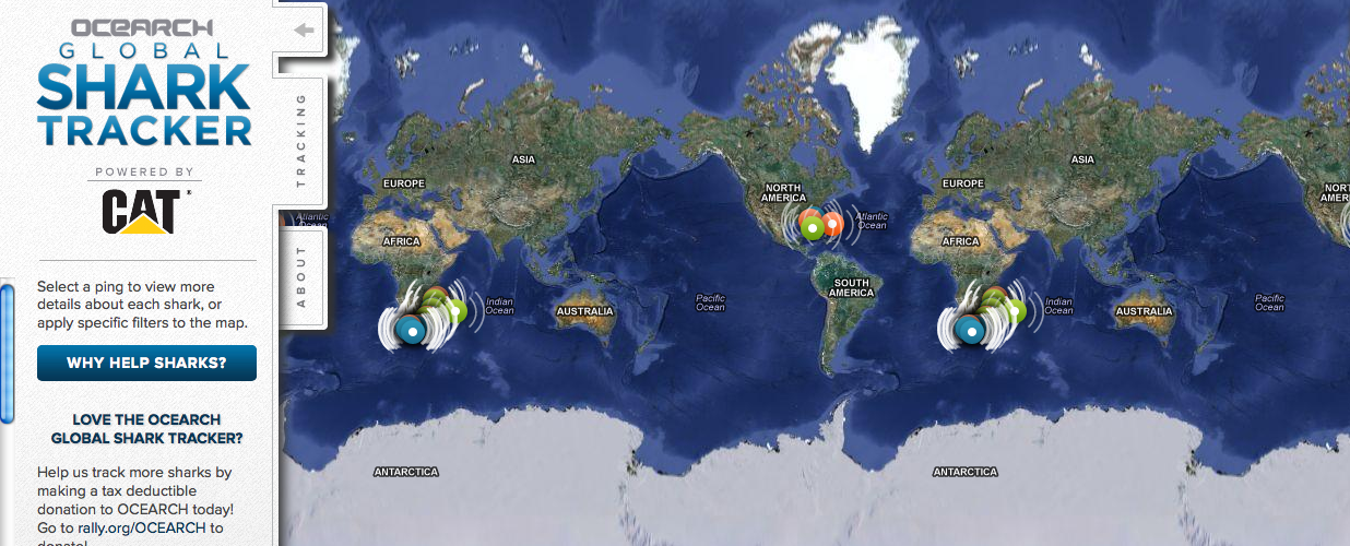
Did you just watch Jaws? Are you worried your trip to the beach might be interrupted by an unwelcome guest? Now you can go online and see if any great white sharks are visiting nearby waters (the tagged sharks, at least.)
The Ocearch Global Shark Tracker is a global project to tag and track the navigational patterns of great white sharks in the world’s oceans. The team is currently tracking nearly 40 sharks. The team of scientists have 15 minutes to pull a shark from the water, tag it, and release it, a process which was highlighted in an ABC Nightline feature.
Ocearch’s founder is Chris Fischer, former star of the History Channel reality TV show “Shark Wranglers.” Ocearch is “seeking to attain groundbreaking data on the biology and health of sharks, in conjunction with basic research on shark life history and migration,” according to its website.
On the Shark Tracker, sharks that have been tagged appear as bright colored dots. Orange means a ping is less than 72 hours old, green means a ping is less than 30 days old and blue means a ping is more than 30 days old.
Swedish-based Handheld, maker of mobile computers designed for extreme environments, has integrated u-blox’ GPS modules in four of its most popular products: the Algiz 7 and Algiz 10X tablets, Algiz XRW notebook, and Nautiz X1 smartphone. These tough computers are designed for and used in demanding environments such as polar expeditions, marine exploration, and rescue operations, as well as outdoor industrial applications such as utility maintenance and logistics. The devices depend on u‑blox’ LEA, NEO, and AMY families of compact, high-performance GPS modules to provide reliable navigation and positioning in challenging conditions.
“Handheld is proud to have achieved an industry-leading position for dependable, ruggedized mobile computers that can be trusted to work in the most hostile environments” said Jerker Hellström, CEO Handheld Group, “To achieve this extremely high-level of performance, we only select components with the highest reliability on the market. GPS positioning is one of the most important functionalities of our products. For this mission-critical feature, we chose u-blox.”
Handheld’s lineup of rugged PDAs and mobile computers is specifically developed for use in tough environments in industries such as geomatics, logistics, forestry, public transportation, construction, mining, field service, utilities, maintenance, public safety, military and security.
With the introduction of a new version of Pocket 3D software for its HiPer SR GNSS receiver, Topcon Positioning Systems is expanding the delivery of high-accuracy 3D positioning technology to contractors needing a low-cost, one-man layout and measurement system.
Pocket 3D is powerful, easy-to-use data collection and control software for grade checking and other measurement applications on a job site. Version 10.0.2 makes it fully functional with the HiPer SR receiver, introduced in August.
The new receiver is not only “perfect for contractors, but also for other non-traditional GNSS users such as landscape architects, law enforcement forensics projects or any others requiring high-accuracy 3D positioning,” said Tony Vanneman, Topcon construction products marketing manager.
Its field-rugged and fully-integrated design delivers a 1,000-foot working radius through Topcon’s new LongLink technology. “This innovative wireless data link was developed specifically for the HiPer SR, and provides reliable and interference-free base-to-rover communications that don’t require an FCC license to operate,” Vanneman said.
“We took the best signal tracking technologies and packaged them in a small, energy-efficient design,” he said. “Anyone looking for a rugged, easy-to-use, low-cost 3D GPS system will find what they need in the HiPer SR.”
Additional key features of the HiPer SR include:
Shock-resistant magnesium alloy housing – allowing the HiPer SR to take a 6 ft. (2m) pole drop onto concrete;
Researchers at Israel’s Ben-Gurion University of the Negev (BGU) say reveal that data culled from geosocial networks like the GPS traffic app Waze can help prevent traffic incidents with better deployment of police resources at the most accident prone areas.
“Only now are we beginning to discover the potential in the huge amount of data collected daily,” explains BGU researcher and Ph.D. student Michael Fire. “Studies of this kind, which monitor events such as traffic accidents over time, can help the police identify dangerous sections of roads in real time, or alternatively, locations where few police are needed.”
The paper, “Data Mining Opportunities in Geosocial Networks for Improving Road Safety,” was presented at the IEEE 27th Convention of Electrical and Electronics Engineers in Israel.
Waze records location data and enables users to upload and share comments on any detail, including traffic alerts, accidents or police presence. According to its website, Waze has 30 million worldwide users and describes itself as “a community-based traffic and navigation app whose users share real-time traffic and road info, saving time and gas money.”
Using Waze data and Google Earth, the BGU researchers determined that three-quarters (75 percent) of the locations in Israel with the highest number of accidents were intersections. They then analyzed references to a police presence to determine if the police were present at the spots that had the worst traffic accidents.
“There were numerous instances where the police were manning quieter intersections, while busier intersections went unmonitored,” Fire explains. “According to the data, police response time varied from 20 minutes to 40 minutes in some situations.”
Using Waze, data from May and June 2012 was collected and analyzed on accident reports, police presence, traffic jams, and speed traps. BGU researchers identified 579 different locations in Israel that had at least five reoccurring accidents during this time where 5,156 reported accidents occurred. Police were reported at least 15 times at more than 3,500 locations.
Other researchers involved with the study from BGU’s Department of Information Systems Engineering and BGU’s Telekom Innovation Laboratories include Prof. Yuval Elovici, head of the lab, as well as Dr. Rami Puzis, Prof. Lior Rokach as well as student Dima Kagan.
Trimble introduced today the Yuma 2 rugged tablet computer, which it says is a powerful mobile computing solution that provides full office capabilities in the field for construction, transportation, public safety, field service, forestry, utilities, mapping, insurance and any other outdoor or service-related industry.
The Yuma 2 offers a seven-inch capacitive multi-touchscreen in an easy-to-hold form factor that measures 6.3 x 9.6 inches, and weighs less than three pounds. Featuring new display technology for clearer readability in direct sunlight, the Yuma 2 can be used by mobile workers in the brightest outdoor conditions. The 3.75G dual-mode cellular data capability enables connectivity anywhere GSM or CDMA cellular networks are available.
Featuring the Microsoft Windows 7 Professional operating system, the Yuma 2 is a fully functional field computer with a 1.6-GHz Intel Atom dual-core processor, 4 GB of DDR3 DRAM, a 64-GB solid state drive (SSD), and a dual battery with eight hours of typical run-time. Optional features include a 128-GB SSD, 3.75G cellular data connectivity and an extended battery set that provides up to 16 hours of operation.
With the multi-touch capacitive touchscreen, users can type with fingers, stylus, or capacitive gloves and can control the size of the keyboard on the display for ease of use. Controlled zoom can optimize the user experience with maps and detailed information. The display supports use in landscape or portrait mode and is configurable to hold the orientation or to alter it in response to the accelerometer. The 5-megapixel camera provides video and photo capture with geotagging. The GPS receiver provides 2 to 4 meter accuracy, and is designed for data collection in applications such as distributed asset management, work order management, fleet logistics and more.
“Ruggedness and connectivity in the field are vital for mobile workers — and Trimble has a history of providing innovative computing solutions to the market,” said Jim Sheldon, general manager of Trimble’s Mobile Computing Solutions Division. “Today, users demand solutions that are even tougher, faster, more reliable and easier to use, so they can be more efficient and productive. With new features and functionality, the Yuma 2 is an ideal solution that provides even more computing power to mobile professionals — more memory, computing speed, drive capacity, connectivity options and better display readability.”
As with other Trimble rugged mobile computers, the Yuma 2 meets stringent MIL-STD-810G military standards for drops, vibration and humidity; and with an IP65 rating, it is protected against dust and water.
Four different configurations are available to provide the tablet that meets the right need at the right price. Options include a larger SSD and 3.75G GSM and CDMA cellular data capability, as well as three different color schemes.
The Trimble Yuma 2 tablet computer is expected to be available early in the fourth quarter of 2012.
LiveViewGPS, a GPS tracking company for business, government and individuals, is now shipping its VLS 300VZ GPS vehicle tracker that operates exclusively on Verizon’s CDMA wireless system. The hard-wired unit features a three-wire hookup and can be configured to update vehicle locations at 1-, 2- and 5-minute intervals.
The VLS 300VZ GPS vehicle tracker is based on LiveViewGPS’ VLS platform, an Internet-based GPS tracking system for small businesses that need powerful monitoring at a lower price, the company said. It includes a fully-featured, real-time, on-demand GPS tracking system with no software and no contracts required.
Users log on via their web browser or web-enabled mobile device. Once connected, the intuitive, user-friendly interface lets them locate multiple vehicles via a high-resolution satellite map. Users have the option of calling a special phone number instead of using a mobile device. The system automatically texts or emails alerts whenever it detects a vehicle speeding, entering restricted zones, deviating from routes and more. Automated detailed reports include starts/stops, excessive idling, mileage and speeding. State-to-state mileage reporting is also available.
“The VLS 300VZ GPS vehicle tracker is a low-cost entry device for small fleets, company vehicles and personal vehicles in areas with poor GSM coverage,” said George Karonis, LiveViewGPS CEO, “and it’s even programmed to store and forward information whenever a vehicle loses CDMA coverage, so users never have to worry about data loss.”
Trimble has introduced the Juno T41 handheld computer, bringing a smartphone-inspired option to industries demanding a rugged field computer for data collection and mobile workforce management. The Juno T41 handheld is a developer-friendly computing device for real-world field conditions, with either Windows Embedded Handheld or Android operating systems, Trimble said.
“With the release of the Juno T41, we are providing a rugged handheld that delivers the capabilities and convenience of a smartphone,” said Jim Sheldon, general manager of Trimble’s Mobile Computing Solutions Division. “It’s slim, ergonomic design is thinner and lighter than other rugged computing products in its class today. Powerful, connected, compact and easy-to-use, the Juno T41 handheld computer is ideal for any mobile professional or demanding consumer.”
The initial launch of the Trimble Juno T41 computer features:
Windows Embedded Handheld 6.5 or Android 2.3.4 “Gingerbread” operating system in choice of 10 languages
Multi-touch user interface with capacitive stylus compatibility
8 MP camera with dual LED flash and geo-tagging
3.75G cellular data, SMS text and voice capability option
The United States Department of Justice’s National Institute of Justice (NIJ) recently released a study that evaluated the use of global positioning systems (GPS) technology to monitor high-risk sex offenders on parole in California.
Offenders in the GPS group demonstrated significantly better outcomes than offenders who were monitored in traditional ways. The evaluation showed that risk for a sex-related violation was nearly three times greater for offenders who received traditional parole supervision, than offenders who received GPS supervision. The risk of committing an offense that resulted in an arrest was twice as high for offenders who received traditional parole supervision than for offenders in the GPS group. When compared to traditional supervision, the study found that GPS monitoring costs approximately $8.51 more per day. The outcomes of GPS monitoring, however, are significantly better.
TITLE: Monitoring High-Risk Sex Offenders with GPS Technology: An Evaluation of the California Supervision Program
Across transportation, agriculture, industry, commerce, and finance, GPS has replaced earlier technologies, opened up innovative applications, and led to new ways of doing old things. GPS now plays a key role in the critical infrastructures of all industrialized nations, from the most sophisticated telecommunications system to the production of a simple loaf of bread.
Wheat is the world’s second staple food, and bread its main product. Bakers have been around for 30,000 years. GPS, among its manifold other duties, now also helps bring us our breakfast toast and midday sandwich.
British farmers sow 2 million hectares (5 million acres) of wheat per year, harvest 8 tonnes per hectare (3.6 U.S. tons per acre) and sell it at £150 a tonne ($214 per U.S. ton), making their harvest worth £2.5 billion ($3.9 billion). Nearly a billion pounds-worth ($1.6 billion) goes to make bread.
We use Britain as an example because we are British, but this same truth holds, at much grander scale, when you consider the United States, Russia, and many other European nations.
A vital value chain wends its way from farm to mill to bakery to store to home: in the UK, 99 percent of households buy bread, 99 percent of which is made in this country, 80 percent of it from domestic flour. This relatively closed value chain lets us see how GPS is used, and that its loss would increase the price of a loaf and translate into inflation.
GPS serves as the basis of the precision agriculture, cutting fuel costs and enabling selective and variable rate optimized application of fertilizers. It lets farmers use less manpower, reduces soil compaction, and even minimizes operator fatigue. Farmers now spend much more time on yield monitoring and within-paddock zone management than leaning on gates chewing straws. Though the capital cost of precision agriculture is high, the annual benefits are comparable with the investment. Losing GPS-based precision agriculture would increase the price of bread by at least 2 percent.
Transport logistics is the glue that joins our value chain together. GPS in fleet management optimizes routings, accelerates dispatching, prevents theft, improves driver behavior, and delivers fuel efficiencies. Loss of GPS in the transport links in our chain would increase fuel costs alone by 13 percent.
On top of all this, GPS is the ultimate source of precision timing supporting telecommunications links at every stage of the value chain, from wheat futures trading and banking transactions to voice, data, and Internet traffic.
The sudden loss of GPS in farming, transportation, communications, business management, and retail distribution, would substantially raise the price of bread, hit every household, and impact the national economy.
What applies to a traditional and at first glance low-technology product like bread applies across the board. The recent report on GNSS vulnerabilities by the Royal Academy of Engineering says that GPS and other satellite navigation services have applications so pervasive that there is now a real threat to global security if the systems should fail — or be interfered with. The signals are used by almost every industry: rail, road, aviation, space, maritime, agriculture, energy, surveying, construction, law enforcement and communications.
Dependence on GNSS connects many otherwise independent services into a so-called accidental system — with a single point of failure, the satellite signal. And a satellite signal, says the report, is a weak foundation for important services, since it can fail in dozens of ways.
GPS is no longer the only GNSS, of course, as many nations, recognizing its political and economic value, have developed their own systems, and augmentations to enhance accuracy and integrity. Over the next few years, the number of navigation satellites may approach 150. This will help reduce vulnerability to the loss of GPS and so will be a benefit in the short term.
But the long term is a very different matter. All these systems now use, or shortly will use, essentially the same technology. And, crucially, the same radio frequency bands.
In those frequency bands, GNSS is threatened by rising levels of radio interference. This threat has several strands that are being recognized separately and handled individually, but which taken together will determine the future of GNSS.
We face a Triple Whammy!
The First Threat
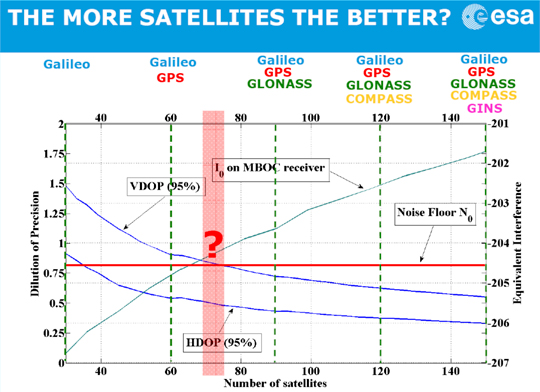
The first component of the Triple Whammy comes from the new satellite systems themselves. Each satellite transmitting in the GPS frequency band increases the noise level there. Satellite navigation receivers must find and lock onto the extremely weak signal that reaches the Earth, digging it out from the background noise of the cosmos. And the other GPS satellites add to the noise level.
Günther Hein of the European Space Agency shows this remarkable diagram (Figure 1): as the number of systems increases and the number of satellites heads for that 150, up rises the noise they make, the blue-green line. More than about 70 of them, and satellite noise exceeds the cosmic noise floor in red and becomes the main source of noise. The more satellites, the worse the reception as GNSS interferes with itself. Too many satellites, and you’d pick up none at all! The first threat of the triple whammy is self-inflicted.
Chart: David Last and Sally Basker
Figure 1. The first threat of the Triple Whammy: new satellite systems. Source: Günther Hein.
The Second Threat
Conflicts between nations as their new GNSSs compete for radio spectrum also threaten GNSS viability.
The frequency bands available to satellite navigation are essentially L2, L5, and the principal one we use currently, L1. On L1, the European Galileo system and the Chinese Compass system occupy the same areas. Now, that’s very desirable if the two systems are to share receivers. But they also compete for that spectrum, and there is conflict between Compass and Galileo.
This battle for spectrum is a highly complex engineering problem. But chiefly, the spectrum wars are political, even emotional.
Chinese satellites fly across American skies broadcasting signals that interfere with European receivers. Spectrum wars have everything to do with relationships between nations and little to do with battles between engineers. They are developing into a classic tragedy of the commons: a situation in which self-interest determines how a limited resource — here the radio spectrum — is to be shared in a regime in which regulation is weak. The International Telecommunication Union sets standards and registers claims. The UN Office for Outer Space Affairs seeks to mediate. But neither is a policeman; sovereign governments may sometimes be penniless, but they are very powerful.
The second threat of the Triple Whammy is also self-inflicted.
The Third Threat
Communications systems compete with GNSS for spectrum: witness the current LightSquared case of a powerful new broadband system. For existing receivers, including those in government systems and aviation, it seems there is no fix for its devastating interference. LightSquared is driven by rich and powerful commercial forces; it could well win this fight.
Communication technologies will continue to press upon the satellite navigation spectrum. LightSquared will likely erode spectrum gaps between communications and navigation services, the so-called guard bands.
Satellite navigation has become highly political. The intense use of GNSS across our economies makes them vulnerable. GNSS is threatened by a Triple Whammy, by jamming, and by spoofing. These increase the risks to our security and our economies, both in probability and impact. The solution of detecting jammers and making ownership illegal will help with local problems in local areas. But the Triple Whammy threats are not local; they are national and international, world-wide.
Today’s spectrum wars affect us all. That the loss of GPS would increase the price of a loaf — the very trigger for the French Revolution — brings this down to earth.
These are not technical issues, they determine the price of our food! They constitute a real and present danger to our societies — down to the mundane yet very real level of our daily bread.
David Last is a past-president of the Royal Institute of Navigation, a consultant and expert witness on radio-navigation and communications systems to companies, governmental and international organizations, and criminal investigators.
Sally Basker, former director of research and radionavigation at the General Lighthouse Authorities of the UK and Ireland, has opened Traxis Ltd: management, business, and technology advice with expertise in navigation service provision. See www.traxis.co.uk.
This article is adapted from a presentation at the European Navigation Conference, London, November 2011. A longer version of the talk appears in the Royal institute of Navigation News.
Many maritime users today believe that GPS will always be available. This is simply not the case.
By Alan Grant, Paul Williams, George Shaw, Michelle De Voy, and Nick Ward, The General Lighthouse Authorities of the United Kingdom and Ireland
GNSS availability can be affected in many ways, through events or conditions that affect constellation health, the signal-in-space, or the reception of that signal. The primary means of positioning, navigation, and timing (PNT) employed in maritime applications, whether stand-alone or augmented, has well known vulnerabilities.
This article considers three specific threats and reports on how they may affect maritime safety: GNSS interference and jamming; constellation availability; and space weather events.
Interference and Jamming
There has been a marked increase in both the use and the availability of GPS jamming equipment in recent years. The implications are that jamming units may find their way onto ferries and around ports or harbors where they will interfere with the many systems utilizing GPS, thus affecting maritime safety.
GPS jamming units are widely available on the Internet, with current models already capable of jamming L1, L2, and L5 signals. While we report here on the jamming of GPS, all GNSS constellations would be affected in a similar manner.
To understand the effects of jamming and GPS service denial on maritime safety, the General Lighthouse Authorities of the United Kingdom and Ireland (GLAs) conducted two jamming trials, in collaboration with the UK Government’s Ministry of Defence (MOD), who provided and operated the GPS jamming units. For the safety of all GPS users, and in line with MOD regulations for the peacetime use of GPS jamming units, notice was given to all national bodies. In addition, the GLAs issued notices to mariners explaining that aids to navigation (AtoNs) using GPS in the vicinity of the trials location would be unreliable during the jamming periods.
Flamborough Head. The first jamming trial was conducted off the East coast of the United Kingdom near Flamborough Head. The aim of this trial was to understand the effect GPS jamming may have on ship-borne and shore-based equipment, GLA AtoNs, and also on the crew.
The Northern Lighthouse Board vessel Pole Star steamed between two known waypoints, through an area affected by the jamming signal. Data was recorded from two typical marine-grade GPS receivers installed on the vessel, along with an eLoran receiver that provided the true position throughout the trial.
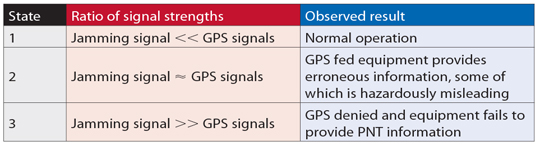
The results identified three distinct states (Table 1) corresponding to the manner in which GPS-fed equipment responded to jamming conditions. When the jamming signal was sufficiently strong to prevent reception of GPS signals, a large number of alarms sounded on the bridge almost simultaneously, providing a potentially disconcerting and confusing environment for the mariner. However, the effect that represented the highest risk was the provision of erroneous data from some GPS receivers.
Table 1. Effects observed for the three states identified from Flamborough Head trials.
Figure 1 compares an erroneous position reported by a typical marine-grade GPS receiver with the vessel’s true location. In this figure, the light blue line shows the path taken between the two waypoints.
The colors of the plotted position points indicate vessel speed. The three states described in Table 1 can be seen.
State 1 is observed at either end of the passage where the solid blue line occurs; this is where the jamming signal strength is much lower than the GPS signal strength, and the GPS-fed systems are operating normally.
As the vessel approached the main lobe of the jamming signal, indicated by the red lines, it reached an area where the jamming signal was comparable with the received GPS signals, leading to State 2. During this state, erroneous data can be observed with the receiver reporting the vessel on land traveling at high speed.
As the vessel entered the main lobe of the jamming signal, State 3 was observed: the GPS signals were swamped by the jamming signal, and the receivers failed to provide an output. Then, as the vessel continued the passage out of the jamming area, one can observe the change in states as the ratios of jamming to GPS satellite signals decrease, and GPS is reacquired.
In the worst case, the GPS receiver reported a position some 22 kilometers away from the true location. The GPS receiver nevertheless declared the position valid. This position was made worse by the fact it was reported inland at a speed of more than 100 knots, while the trial vessel steamed steadily at 10 knots. Depending on how the resulting GPS positioning data is used, it could feasibly result in vessels changing course, through the use of an autopilot, and it could also affect the vessel’s reported position to the outside world. This would then not only affect the vessel’s situational awareness but also the situational awareness of vessels in the vicinity.
The errors observed in Figure 1 were also seen on the vessel equipment fed by the onboard GPS receivers. Erroneous positions were observed on the vessel’s electronic chart display and information system (ECDIS), on the automatic identification system (AIS) positions (where loss of position prevents the unit from calculating a range or bearing to nearby vessels, greatly affecting the crew’s situational awareness), and on the vessel’s radar (Figure 2).
The results observed during these trials gave an important example of what can happen to onboard equipment as well as the impact it can have on the mariner during periods of GPS jamming and service denial. It is clear that GPS denial caused by jamming can not only prevent PNT information from being calculated, it can also result in erroneous data being presented to the mariner.
Newcastle. A second series of demonstrations was conducted off Newcastle-upon-Tyne, on the North East coast of England, to communicate the importance of resilient PNT to a selected audience. The audience included a number of key decision-makers from European and UK governments, maritime industry, mariners, and other aids-to-navigation service providers. The demonstrations took place onboard the Trinity House vessel Galatea.
For this trial, the GPS jamming unit was installed onboard the Galatea and configured to jam GPS within a small
area around the vessel. As before, two typical marine-grade GPS receivers were installed along with an eLoran receiver; for this trial, a modified electronic chart display was also installed and altered to enable two position inputs to be displayed at the same time, to compare the reported GPS and eLoran positions in real-time.
Throughout the demonstrations differential Loran (dLoran) corrections were provided using a transportable reference station installed on the shore at South Shields, to mitigate the impact of temporal variations on the eLoran position. Differential-Loran corrections were generated by the reference station and sent to the GLAs’ eLoran transmitter in Cumbria for inclusion in the eLoran Loran Data Channel (LDC) broadcast. The eLoran receiver on the vessel received the broadcast and was able to extract and apply the corrections in order to obtain an eLoran position within 9 meters (95 percent).
One demonstration scenario showed the sudden effect of a strong jamming signal, designed to simulate a jamming unit being brought onto a ferry or other vessel. This took the vessel’s equipment directly to State 3: complete loss of GPS information with a large number of alarms sounding on the bridge. The loss of GPS data prevented the Galatea’s AIS and VHF units, among other systems, from operating correctly.
Before the second scenario was conducted, the jamming unit was stopped, and all of the GPS receivers integrated into the bridge equipment were allowed to reacquire satellites and fully recover. The second scenario was designed to reflect a vessel steaming towards a jamming source. The field strength of the jamming signal was slowly increased until State 2 was observed, with erroneous and often hazardously misleading information reported.
As with the Flamborough trials, erroneous GPS positions reporting unfeasibly high speeds were observed as shown in the OPENING Figure. However, significantly more subtle errors were seen: errors where the vessel’s reported position differed only very slightly from the true location and wandered around slowly. These subtle changes produce believable positions but hazardously misleading information (HMI). While the overall result of GPS jamming on Galatea was consistent with that observed on Pole Star, there were a few marked exceptions.
The effect of GPS jamming can be seen (Figure 3) on the erroneous positions reported by the trial vessel NLB Pole Star (center right) and also on the vessel DutchProgress (top left).
The ECDIS onboard the Pole Star reported erroneous positions and ultimately failed with the complete denial of GPS. However the ECDIS on the Galatea continued to track the vessel’s position due to an additional position feed from the vessel’s gyro, making it more resilient to jamming, but only in the short term until the gyro requires re-calibration. This is carried out with its built-in GPS receiver! In addition, the AIS transceiver on the Pole Star reported the vessel’s position erroneously due to jamming, and this was observed at shore-based traffic monitoring stations.
During the demonstrations on the Galatea, the AIS transceiver did not provide any erroneous position information, as can be seen in Figure 4. These differences show that the impact of GPS jamming will be different for each vessel and depends on the model, installation, and configuration of the onboard systems.
Effect of Jamming on Safe Navigation
To navigate safely, the mariner needs reliable, clear and trusted information about where the ship is and what is going on around it, so that any threat can be located and identified. While consideration is often given to threats such as areas of shallow water, obstacles, or other vessels; consideration is not generally given to the loss of positional information, timing, or situational awareness.
Loss of GPS-derived PNT information at sea results in the loss of the vessel’s ECDIS, AIS, GPS, and DGPS receivers, preventing the mariner from being able to position the ship and others around it through what are nowadays regarded as the normal means. In addition, the systems one would normally expect to be independent from GPS, and as such available for use in GPS-denied conditions, are also affected; namely the vessel’s radar and gyro-compass.
The radar takes a GPS input to provide a “North-up” setting and the gyro-compass uses GPS to stabilize drift error. Under GPS-denial conditions these units also enter an alarm state and should not therefore be used in that condition.
Clearly GPS jamming can significantly affect the safety of mariners. From these trials it can be seen that the extent of the impact varies from vessel to vessel depending on the equipment installed and the configuration selected.
Satellite Constellation. From the users’ perspective, GNSS availability is the percentage of time they can receive usable data from sufficient satellites in order to calculate their position. The reduction in the number of available satellites in the constellation will have a direct impact on the system’s availability.
A report from the U.S. Government Accountability Office (GAO) in 2009 predicted “significant challenges in sustaining and upgrading widely used [GPS] capabilities” due to delays in launching modernized GPS satellites. The GAO reported the probability of maintaining a constellation of at least 24 usable GPS satellites could reduce to 80 percent or less by 2011, and not return to 95 percent probability consistently until 2015. This could lead to reduced satellite numbers causing coverage “windows” where less than four satellites could be observed and as such reduced GPS availability.
A later report by the GAO indicates that the probability of maintaining a constellation of at least 24 operational GPS satellites is now expected to be 95 percent for the foreseeable future. This figure is based on the current launch schedule, and although the U.S. Air Force Space Command (AFSPC) has provided reassurances, the satellite launch program has in recent years experienced delays, and therefore the risk of reduced satellite availability still remains.
Following the 2009 report, the GLAs commissioned a study to investigate the impact a reduced GPS constellation would have on users in their waters. This study was conducted by the GNSS Research and Applications Centre of Excellence (GRACE) and was split into two parts. The first part was to analyze the impact theoretically and found that with a 21-satellite constellation, GPS coverage “windows” (for example, fewer than four satellites) could last for several minutes and cover a large proportion of the UK and Ireland (Figure 5). This can cause reduced GPS availability and therefore increased likelihood of position errors affecting maritime safety.
The second part of the study investigated the effects further through a dynamic simulation, investigating the effects should a vessel be position
ed off the coast of Belfast during one of the coverage windows. For this a marine-grade GPS receiver and a simulator were used to observe the effects. The study found that the number of available satellites fell below four for several minutes and the reported position data from the receiver appeared to freeze for up to 10 minutes.
If a mariner was traveling at a speed of 35 knots when the position input froze, his reported position would be in error by 10 kilometers from an outage lasting 10 minutes. These outages are significant, and mariners need to be informed of such risks to GPS (and GNSS in the future) before they occur, so they are prepared for any disruptions.
Space Weather. Space-weather events are a particular concern to GNSS availability due to their random nature. It is known that GNSS signals are delayed proportionally to the number of free ions as they propagate through the Earth’s atmosphere enroute to the receiver. The amount of ions in the ionosphere, the total electron count (TEC), is dependant on time of day, latitude, and solar activity, among other factors. During high solar activity, the number of ions in the atmosphere is much higher than at any other time. The greater the signal delay, the larger the errors are in the satellite’s pseudo range and hence the position error can be significant.
Variation in electron density along the GNSS signal path causes signal refraction that produces phase scintillation, introducing group delay that may cause large errors in the pseudorange measurement. Diffraction of the signal wave front induces amplitude scintillation — variations in signal amplitude — with strong fades possible, leading to a GNSS receiver losing signal tracking, and at worst the GNSS navigation solution may be lost.
Solar activity is cyclical, peaking at a maximum approximately every 11 years, during which periods GNSS performance can be severely degraded, especially at equatorial, auroral and polar latitudes. The next solar maximum is predicted to occur during 2013.
During quiescent periods of solar activity, ionospheric effects on GNSS can be managed such that the residual errors caused by the ionosphere do not generally pose a problem to maritime navigation performance.
The GLAs’ DGPS corrections significantly reduce common mode errors, including the effects of the ionosphere. However, at the peak of the solar cycle with high levels of sunspot activity, solar storms and flares, the application of ionospheric models and differential corrections may be less effective, and this could increase position errors and introduce an integrity risk to maritime navigation.
Maritime navigation systems and services that rely on GNSS are at greatest risk of disruption from the ionosphere during the period from 2011 to 2015. Even during a quiet solar maximum, the occurrence of individual sun spots could produce significant effects for discrete events. The effects vary with latitude, season, and time of day (the hours soon after sunset being most affected).
Space weather events have the potential to affect GNSS availability, either by affecting the performance of the satellites themselves or by preventing signal reception.
Mitigation. In general, a number of steps can be taken to help reduce the impact of these threats:
Increase awareness of GNSS vulnerabilities.
Detect incidents and warn the mariner when they occur.
Prevent incidents from occurring, where possible, through legislation and enforcement.
Reduce as much as possible the effects of incidents when they occur, through the hardening of GNSS technology.
Have alternative means of PNT, independent of GNSS.
Understanding that these threats exist and knowing what disruption they may cause is the first step to mitigating their effects, but this does not stop them happening. Being able to identify that an event is occurring and that the data being received from the receiver may not be true is an important part of mitigating the effects.
For jamming issues specifically, the use of GPS jamming units is illegal in the UK and Ireland; however, preventing them from being used is very difficult to achieve. Jamming units are small and easily hidden; however, port-side security and vessel security procedures should prevent jamming units from being used in these locations.
It is a different case, however, to prevent a jamming unit from being used at a coastal location or headland due to the remote nature of these areas.
Mitigating the effect of jamming can be achieved in a number of ways: by limiting the effect within the receiver by using anti-jamming techniques, or by hardening GNSS receivers. Ultimately the best mitigating activity is to not rely on GNSS PNT once the integrity of the data has been compromised.
For space weather events or cases of reduced satellite numbers, there is very little action the mariner can take to remedy the problem or stop it happening. The mitigating action here is one of awareness — information forewarning the mariner that such a condition is imminent, for example.
Monitoring and detection networks can assist in providing such notifications and real-time information on GNSS problems. The need for such a network across the UK and Ireland is the subject of a different GLA publication, but the GLAs support the discussion on a body to monitor GNSS performance and to take the lead in the dissemination of key information.
For periods where GNSS availability has been affected by mutual interference, jamming, space weather events or constellation issues, the best mitigating action is to use PNT information from a second source, one with dissimilar failure modes.
Mariners need to be prepared for GNSS failures and have access to PNT information through dissimilar systems. In addition, procedures covering what to do in the case of GNSS unavailability should also be provided and rehearsed. It is with this view that the GLAs firmly promote the use of all available means of navigation.
Conclusions
All three threats to GNSS availability reviewed here could affect maritime safety. The two trials observed presentation to the mariner of erroneous data, some of which could be considered hazardously misleading, along with the degradation of crews’ situational awareness. The main effects observed were:
The presentation of random errors leading to hazardously misleading information that could, depending on installation, cause a vessel to move off course.
The presentation of erroneous and potentially misleading data to other vessels and shore-based infrastructure.
The sheer number of alarms on the bridge of the vessel could be disconcerting and distracting for the mariner.
The loss of GPS-fed systems, which can create an unfamiliar bridge situation and remove safety-critical systems from operation.
A large number of bridge systems are integrated with GPS and enter an alarm state during periods of GPS outage.
The loss of GPS or a lack of integrity in the reported information leads to an unfamiliar situation on the bridge.
The crews of the Pole Star and the Galatea were expecting to lose GPS, were well-trained, and had primed other systems so they could navigate safely. In real life, there would be no advance notice, and the impact on the crew would be more severe.
The impact of low satellite numbers, as predicted in the 2008 GAO report, could produce poor constellation availability and a loss of PNT information for a considerable period of time. This could result in the same outcome as observed in the GPS jamming trials when entering State 3, where many systems on the bridge failed and entered an alarm condition.
Space weather events are difficult to predict both in terms of when they may occur and their severity. Events could affe
ct satellite positions, their operation, and the reception of their signals by the user, and are clearly a threat.
The GLAs strongly support the need for a resilient PNT solution, one that could continue to provide reliable information during such threats for the safety and benefit of all mariners.
Acknowledgment
This article is based on a paper given at the Institute of Navigation’s 2011 International Technical Meeting.
Alan Grant is a principal engineer for the Research and Radionavigation Directorate of the GLAs of the UK and Ireland, technical lead and project manager for all GNSS projects there. He has a Ph.D. from the University of Wales.
Paul Williams is a principal development engineer with the Directorate and currently technical lead of the GLAs’ eLoran Work Programme. He has a Ph.D. in electronic engineering from the University of Wales.
George Shaw is an engineer at the Directorate and holds a master’s degree in mathematics from the University of Cambridge.
Michelle De Voy is a development engineer for the Directorate, with an MSc in oceanography from the University of Southampton and an MSc in satellite positioning from the University of Nottingham.
Nick Ward is research director of the General Lighthouse Authorities of the UK and Ireland, with responsibility for strategy and planning of research and development.


 Trimble has introduced the