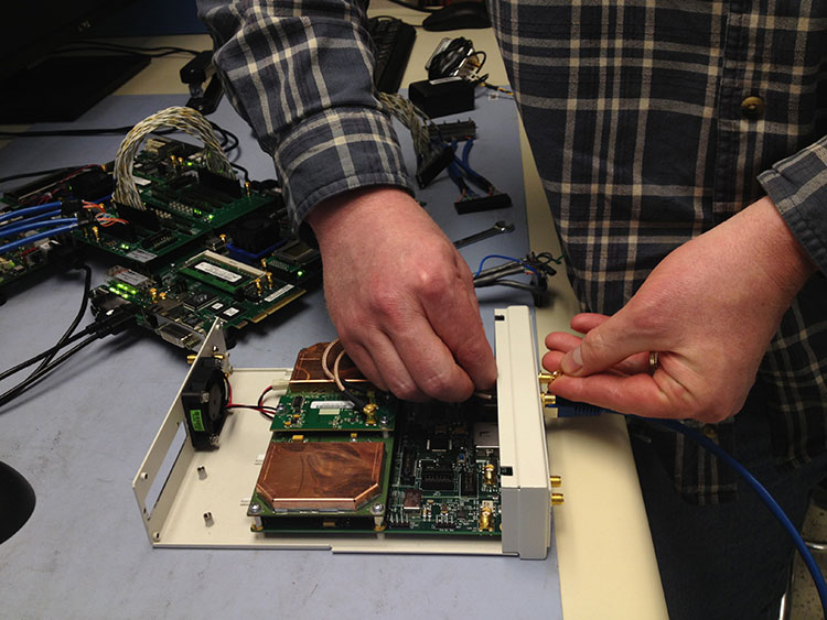
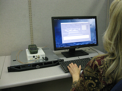
Jim Lau of Racelogic details the company’s GNSS Simulator and VBOX Speed Sensor IMU while at Unmanned Systems 2015, held May 4-7 in Atlanta. VOBX is a 100Hz dual antenna GPS/GLONASS speed sensor (VBSSISL) that combines signals from an integrated inertial measurement unit (IMU) with those from GPS to provide smoother output data even when satellite reception is interrupted.
Tag: Racelogic
-
2015 Simulator Buyers Guide
Special Section, March 2015. Download a PDF of this section, with the Simulator Product Showcase.
CAST Navigation
CAST-SGX GPS Satellite Simulator
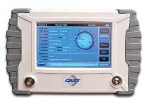
The SGX GPS satellite signal simulator from CAST Navigation. Photo: CAST Navigation The SGX GPS satellite signal simulator from CAST Navigation provides the user with dynamic, repeatable GPS RF signals for use in the laboratory or in the field for a wide range of GPS applications. The SGX simulator is housed in a portable, lightweight, handheld enclosure measuring 7 x 11 x 3 inches and weighing just over 4 pounds.
The SGX is lightweight and portable, operates on AC or battery power, and features 16 channels of L1 C/A and P codes. Based on CAST’s technology that has been developed for use in the company’s larger military products, it is extremely accurate and repeatable.
The SGX is controlled via an intuitive touchscreen interface that allows the user to select, start, and stop scenarios, change screen views, and change satellite RF power levels while a scenario is running. Three test scenarios are delivered with the simulator.
XGEN Plus Scenario Generation Software. This software gives the user the ability to generate custom scenarios for use with the SGX. The software allows for complete control over GPS almanac, ephemeris, and all satellite error sources.
The user can select from a variety of vehicle types and simulate static or dynamic motion. The user can also employ antenna gain patterns and vehicle silhouettes if desired. The user can generate a customized high precision six-degree-of-freedom trajectory simply by defining a mission profile that is based on raw maneuvers, waypoints, Google Maps or a combination of these maneuver types.The new scenarios can be downloaded via USB port or SD card interfaces.
CAST has been in the GPS simulation and support business for more than 30 years, designing, developing, manufacturing, and integrating innovative GPS/INS simulators and associated test equipment for government, military, prime vendor, and consumer markets.
www.castnav.com; phone: 978 858-0130; email: [email protected]
Cobham AvComm (formerly Aeroflex)
GPSG-1000 — Portable GPS/Galileo/SBAS Positional Simulator

Aeroflex
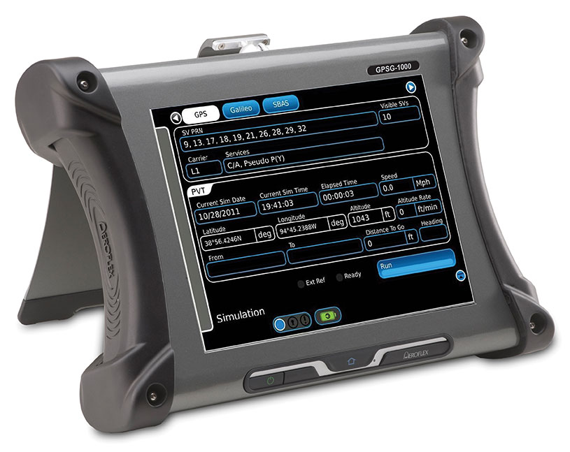
GPSG-1000: Portable GPS/Galileo/SBAS Positional Simulator Photo: GalileoDesigned to be a versatile yet affordable satellite simulator, the GPSG-1000 is proving to be a vital instrument used by those validating and testing GNSS receivers in a variety of applications within the transportation, consumer electronics, aerospace and military industry segments, to name a few.
The GPSG-1000 is a single carrier, multi-channel GPS/Galileo simulator that is portable and ruggedized so it can be safely and confidently deployed in a variety of outdoor and indoor environments. The unit is available in a 6- or 12-channel configuration, and supports the following GNSS signals: L1, L1C, L2C, L5, E1, E5, E5a, E5b and SBAS (WAAS and EGNOS).
The GPSG-1000 can be directly connected to a GNSS receiver under test. It can also simulate actual “open-sky” situations whereby the unit can generate its signals through the included antenna coupler system that isolates and transmits to the UUT’s antenna(s). Utilizing an integrated GPS receiver, the GPSG-1000 simulates actual time of day and date as well as the real constellation that would be available for navigation at that specific point in time. Multiple almanacs and route files can be saved to the GPSG’s memory, thereby enabling current and past history dynamic motion, constellation environment creation/recreation and other significant troubleshooting capabilities. During any given static or dynamic simulation, space vehicle parametrics and health can be user controlled.
The GPSG-1000 features a touchscreen user interface that can be remotely hosted via an integrated Ethernet port. The unit uses a rechargeable, Lithium Ion battery enabling hours of untethered use, and can also be used while the battery is recharging.
ats.aeroflex.com; phone: (316) 522-4981 or (800) 835-2352; email: [email protected]
IFEN Inc.
NavX-NCS Professional GNSS Simulator
NavX-NCS Essential GNSS Simulator
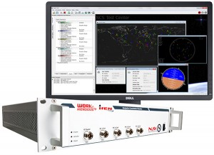
The NavX-NCS Professional GNSS Simulator by IFEN. Photo: IFEN The absolute flexibility of the NavX-NCS Professional GNSS Simulator allows it to be configured with up to 108 channels and all of the following signals:
- GPS L1/L2/L5 C/A & P code and L2C
- GLONASS G1/G2 standard & high accuracy codes
- Galileo E1/E5/E6 (BOC/CBOC/AltBOC)
- BeiDou B1/B2/B3
- SBAS L1/L5 (WAAS, EGNOS, MSAS, GAGAN)
- QZSS L1 & L1-SAIF
- IMES
The user is enabled to assign signals freely to any of the RF modules fitted to the simulator. This allows the same hardware to be used in a range of different configurations.
Signals may be added by software license with no need to return the hardware for upgrade.
Up to four independent RF outputs may be fitted, enabling the user to simulate multiple antenna locations simultaneously (allowing simulation of multiple antennas on one vehicle, multiple vehicles simultaneously, a mixture of static locations and mobile vehicles, and multiple antenna elements for Controlled Reception Pattern Antenna [CRPA] testing).
The comprehensive and easy-to-use Control Center operating software allows the operator to quickly create realistic test scenarios for effective testing of user equipment.
IFEN also offers the NavX-NCS Essential GNSS Simulator, which is available with 21 or 42 channels and is capable of simulating GPS L1 (including SBAS L1), GLONASS G1, Galileo E1, BeiDou B1, QZSS L1, and IMES. The simulator is also supplied with Control Center operating software for comprehensive scenario generation.
For USA and Canada: Mark Wilson; phone: 951-739-7331; email: [email protected]
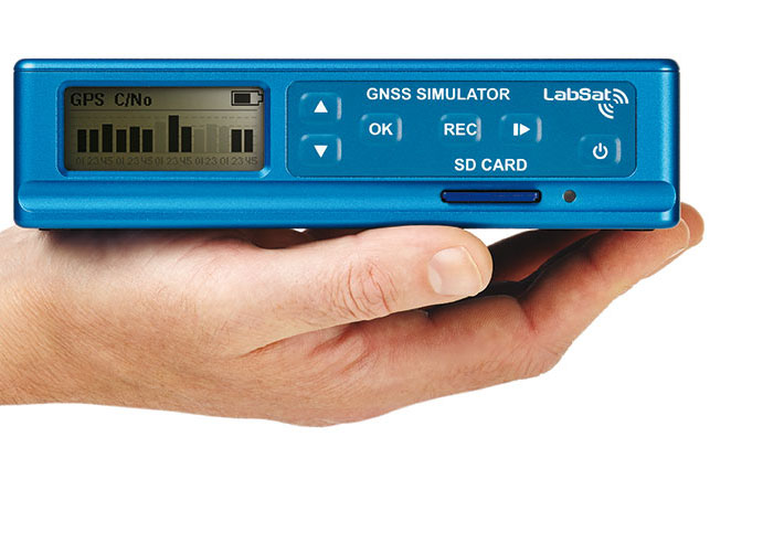
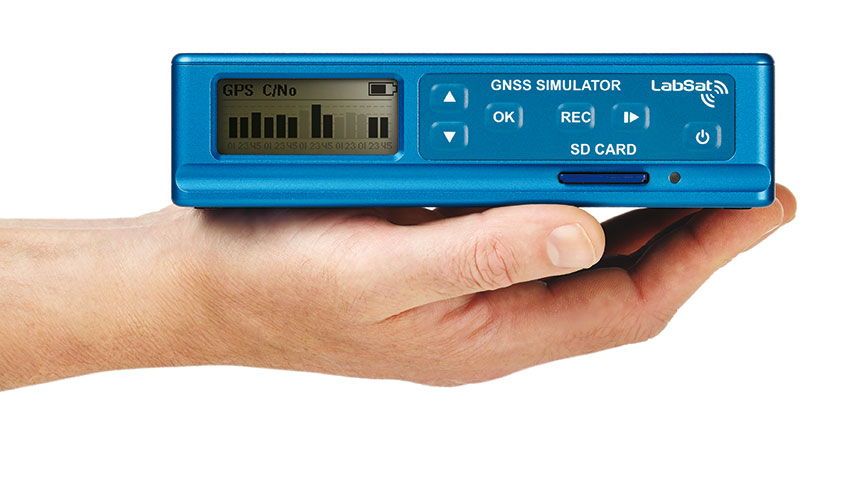
Racelogic
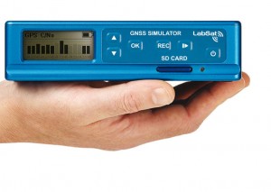
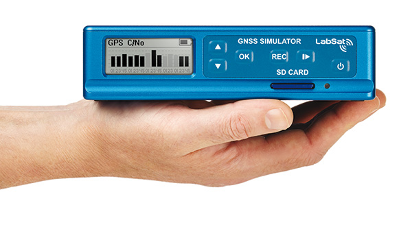
LabSat 3 Triple Constellation Simulator
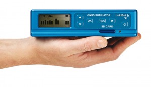
RaceLogic LabSat 3. Photo: RaceLogic LabSat 3 from Racelogic is a low cost, stand-alone, battery powered, multi-constellation RF record-and-replay device, designed to assist GNSS engineers in the development and testing of their products.
With its small size and all-in-one design, LabSat 3 makes it easier than ever to collect raw satellite data in the same environment that end users experience in everyday use. This enables repeatable and realistic testing to be carried out under controlled conditions.
LabSat 3 doesn’t need to be connected to a PC in order to record live-sky GNSS signals. With one-touch recording to SD card and a two-hour battery life, it can be used in any outdoor location to create real-world scenarios, for eventual replay back in the lab. As well as being able to simultaneously record or replay GPS, GLONASS, BeiDou, QZSS, Galileo, and SBAS signals, it can log CAN Bus, serial, or digital data, embedded alongside the satellite information. This additional information can then be replayed alongside the GNSS output, with synchronization to within 60 ns. A 1PPS signal can also be generated using the internal GPS receiver.
LabSat 3 can be used as a replay system out of the box with a set of 60 pre-recorded scenarios supplied as part of the package, recorded from various locations around the globe. Additionally, SatGen software, a demo version of which is available from the LabSat website, allows for
scenario generation of user-defined trajectories, with precise control over velocity, heading, height, and constellation profiles. Routes are also easily created in Google Maps, and the software also supports NMEA and KML file import. SatGen gives test engineers the ability to develop their products using simulations that would be difficult or impossible to record due to geographic location or safety constraints.LabSat 3 is available as a record and replay, or replay-only version; either one, two, or three constellation types generate a single, dual, or triple constellation file.
LabSat is currently used by many leading manufacturers of GPS chipsets, portable navigation devices, smartphones, and by major car companies in their test, development and production processes.
www.labsat.co.uk; phone: +44 (0)1280 823803
Rohde & Schwarz
R&S SMBV100A: GNSS Simulator in Vector Signal Generator

The R&S SMBV100A: GNSS Simulator in Vector Signal Generator. Photo: R&S The GNSS simulator in the vector signal generator R&S SMBV100A is designed for development, verification and production of GNSS chipsets, modules and receivers. The simulator supports all possible scenarios, from simple setups with individual, static satellites all the way to flexible scenarios generated in real time with up to 24 dynamic GPS, GLONASS, Galileo, BeiDou and QZSS satellites.
- GNSS simulator with support of GPS L1/L2 (C/A and P code), GLONASS L1/ L2, Galileo E1, BeiDou and QZSS L1, including hybrid constellations.
- Real-time simulation of realistic constellations with up to 24 satellites and unlimited simulation time.
- Flexible scenario generation including moving scenarios, dynamic power control and atmospheric modeling.
- Configuration of realistic user environments, including obscuration and multipath, antenna characteristics and vehicle attitude.
- Static mode for basic receiver testing using signals with zero or constant Doppler shift.
- Support of Assisted GNSS (A-GNSS) test scenarios, including generation of assistance data for GPS, GLONASS, Galileo, BeiDou and QZSS.
- Real-time external trajectory feed for hardware in the loop (HIL) applications.
- High signal dynamics, simulation of spinning vehicles and precision code (P-code) simulations to support aerospace and defense applications.
- Enhanced simulation capabilities for aerospace applications by supporting ground-based augmentation systems (GBAS).
- Support of other digital communications and radio standards in the same instrument.
www.rohde-schwarz.com; email: [email protected]
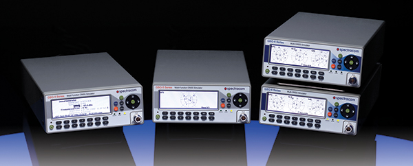
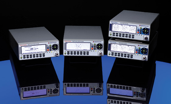
Spectracom
Afforable, Flexible and User-Friendly GNSS Simulators
The Spectracom family of simulators. Photo: Spectracom Spectracom GNSS Simulators support test and development programs from simple manufacturing tests to multi-output testing across the diverse ecosphere of industries relying on GNSS technology. Spectracom’s innovation allows users of any skill level full control over the GNSS constellation, vehicle motion/attitude and signal path complications such as atmospherics and multipath to develop complex scenarios. Typical test conditions include:
- Clock errors
- Data errors
- “Real-world” motion from embedded Google Maps
- In-band noise generation
- Multipath
- Signal obstructions calculated from 3D building models
- “Current time” simulation
- Real-time HIL testing
- Easy synchronization for multi-output testing
- Automative download of the current almanac
- Antenna pattern effects
- Inertial sensor testing
- Assisted GNSS testing
No dedicated PC is required. Scenarios are run and managed from the front panel, SCPI commands, or any PC/tablet via a web interface. Users can select a flexible, field upgradeable Spectracom simulator, and then purchase the software options they need.
GSG-6 Series multi-frequency, advanced GNSS simulator is powerful enough for any cutting-edge test program. GPS, GLONASS, Galileo, Beidou, QZSS and IRNSS signals are available across multiple frequencies. The GSG-6 is designed for military, research or professional applications.
GSG-5 Series multi-constellation L1-band GNSS simulator is designed for commercial development/integration programs. If a user is developing commercial products with GNSS capability, the GSG-5 will shorten test programs with confidence.
GSG-51 single channel signal generator is designed for one purpose — fast, simple go/no-go manufacturing test and validation, ensuring the manufacturing line is operating at full capacity with confidence in quality.
www.spectracom.com; email: [email protected]; phone: 585-321-5800
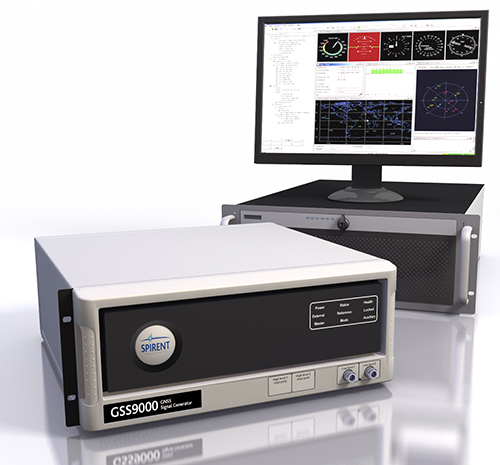
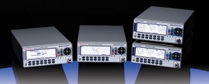
Spirent Federal Systems
GNSS Simulators

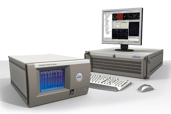
Spirent’s GSS9000 constellation simulator. Photo: Spirent Spirent provides simulators that cover all applications, including research and development, integration/verification and production testing.
GSS9000. The newly released Spirent GSS9000 multi-frequency, multi-GNSS RF constellation simulator can simulate signals from all GNSS and regional navigation. The GSS9000 offers a four-fold increase in RF signal iteration rate (SIR) over Spirent’s GSS8000 simulator. The GSS9000 SIR is 1000 Hz (1 ms), enabling higher dynamic simulations with more accuracy and fidelity. It includes support for restricted and classified signals from the GPS and Galileo systems, as well as advanced capabilities for ultra-high dynamics. It can evaluate resilience of navigation systems to interference and spoofing attacks, and has the flexibility to reconfigure constellations, channels and frequencies between test runs or test cases.
Hardware changes can be done in the field, supported by the new on-board calibrator module. The GSS9000 is extensible and can support the widest range of carriers, ranging codes and data streams for the Galileo, GPS, GLONASS, and BeiDou systems, as well as regional/augmentation systems. Multi-antenna/multi-vehicle simulation, for differential-GNSS and attitude determination, and interference/jamming and spoofing testing are also supported.
CRPA Test System. Spirent’s Controlled Reception Pattern Antenna (CRPA) Test System generates both GNSS and interference signals. Users can control multiple antenna elements. Null-steering and space/time adaptive CRPA testing are both supported by this comprehensive approach.
GSS6425. The Spirent GSS6425 RPS quickly and simply records complex real-world RF environments, capturing both GNSS signals and atmospheric/interference effects. These environments can then be replayed repeatedly to the hardware software under test, reducing project, travel and engineering costs.
www.spirentfederal.com; Jeff Martin, Director of Sales; Kalani Needham, Sales Manager; email: [email protected]; phone: 801-785-1448; fax: 801-785-1294
-
BeiDou Numbering Presents Leap-Second Issue

During preparation of playback scenarios for the upcoming leap-second event taking place in June, engineers at Racelogic identified a potential pitfall for GNSS engineers. The difficulty arises from the fact that BeiDou uses a different “day number” for the date to apply the leap second, compared with GPS and Galileo. GPS and Galileo use 1-7 as week day numbers, and BeiDou uses 0-6.
If this fact has been missed during development, then the result is that the leap second may be implemented a day early on GNSS engines that are tracking the BeiDou constellation, said Mark Sampson, product manager for Racelogic.
“We tested four different Beidou enabled receivers, from four leading GNSS companies, and none of them appeared to handle the Beidou leap second correctly. This included an engine which originates from China!” Sampson said. “We have since been in contact with two of these companies, who have confirmed that their hardware does have a bug in the leap-second code due to the numbering of the days.”
The error presents itself when the receiver is running on the BeiDou constellation alone, and when the date is June 29 of this year. In some cases, the BeiDou leap second will be adjusted from 2 to 3 seconds from midnight on June 29, which should in fact occur on midnight of June 30. This will result in an error for the reported UTC time of 1 second for the period of this day. In other cases, the leap second was not implemented at all when running on BeiDou alone.
“We have also checked the output of a BeiDou signal generator from a different simulator company, and this too uses the 1-7 range for the BeiDou leap-second date instead of the correct 0-6 range,” Sampson said. “This may explain why a number of commercial receivers appear to have been caught out by this issue.”
Racelogic LabSat3 simulator. In order to help companies test for this problem, Racelogic has generated simulated RF data for June 29 and 30, starting 15 minutes before midnight. “We have two sets of files. One set contains BeiDou only signals and the other contains a combination of BeiDou and GPS signals,” Sampson said. “Note that on some of the receivers we have tested, when GPS is being tracked as well, the GPS leap-second message overrides the one coming from BeiDou and applies the leap second correctly.”
The scenarios are compatible with Racelogic’s LabSat3 triple constellation simulator, which is available on a free 15-day loan or can be purchased from Racelogic.
-
Expert Advice: A Leap into the Unknown?
By Mark Sampson
A leap second will be introduced this year at 23:59 on June 30. This phenomenon comes around periodically and is necessary for keeping Coordinated Universal Time (UTC) in line with the small vagaries of the Earth’s slowing rotation. Although it is an event that will pass unnoticed by the majority of people, it has implications for anyone involved in the development of GNSS-enabled devices. For some, it can be the cause of a major headache.
Part of the problem with the leap second is its irregularity. Occurring every two or three years, it means that receiver technology moves on in between — and because the Earth’s slowing rotation is not at a constant rate of change, it cannot be predicted when the next one will be announced. A rapidly developing market of GNSS products having to deal with random alterations to its time framework is not an ideal situation. Suitable preparations, clearly, should be employed.
The behavior of a new receiver when subjected to a leap second may prove critical in certain instances, and without robust characterization it can lead to inconsistent performance. It has already happened this year: on January 21, GPS signals started to include information which effectively announced this year’s leap second event, with the relevant data for future delta time, and week and day numbers. This caused issues with some receivers that weren’t expecting it: some units applied the additional second immediately. It would be interesting to see how these systems might have reacted during an actual leap second transition.
Receiver logic flow requires testing so that any GPS receiver can remain compliant with the IS-GPS-200 standard, and potential problems must be mitigated and controlled. The use of a GNSS simulator — which outputs a scenario containing the leap second event — allows for the receiver and any systems around it to be exercised over and over again, ironing out any anomalies, to ensure total reliability.
The recent issues with those non-compliant GPS engines highlights the advantage that simulation provides. The consistency it delivers enables a very thorough testing schedule, which will in turn lead to a straightforward application of the time change.
One school of thought holds that leap seconds should be abandoned, and that we should stick to atomic time from now on. Their removal would mean that by 2100, the Earth’s rotation would be some two to three minutes behind humanity’s precise, atomic-powered, 24-hour clock, and half an hour or so by 2700.
The World Radiocommunication Assembly, which has control over such matters, had been postponing a decision on whether to abolish the leap second for over a decade; another vote is due this year. It wouldn’t be any great wonder if this prevarication continues, so whilst it still exists, it is best to concentrate on what this June’s extra second might have in store for anyone currently developing a GNSS product. Armed with a simulator, the unpredictability of leap second scheduling should no longer be a major concern. Should this year’s vote be again inconclusive, those who have taken the positive step of acquiring a GNSS simulator will be in good shape to deal with the next time the clocks show 23:59:60.
Mark Sampson is LabSat product manager for RaceLogic.
-
2014 Simulator Buyers Guide
In GPS World’s annual Simulator Buyers Guide, we feature simulator tools, devices, and software from six prominent companies. Also available as a downloadable PDF.
CAST Navigation
CAST-SGX GPS Satellite Simulator

The new SGX GPS satellite signal simulator from CAST Navigation provides the user with dynamic, repeatable GPS RF signals for use in the laboratory or in the field for a wide range of GPS applications. The SGX simulator is housed in a portable, lightweight, handheld enclosure measuring 7 x 11 x 3 inches and weighing just over 4 pounds.
The SGX replaces the CAST-SIMCOM simulator, a 17- inch, 50-pound simulator. The SGX is lightweight and portable, operates on AC or battery power, and features 16 channels of L1 C/A and P codes. Based on CAST’s technology that has been developed for use in the company’s larger military products, it is extremely accurate and repeatable.
The SGX is controlled via an intuitive touchscreen interface that allows the user to select, start, and stop scenarios, change screen views, and change satellite RF power levels while a scenario is running. Three test scenarios are delivered with the simulator.
XGEN Plus Scenario Generation Software. This optional software gives the user the ability to generate custom scenarios for use with the SGX. The software allows for complete control over GPS almanac, ephemeris, and all satellite error sources.
The user can select from a variety of vehicle types and simulate static or dynamic motion. The user may also employ antenna gain patterns and vehicle silhouettes if desired. The user may generate a trajectory by defining a total mission profile using a six-degree-of-freedom model. The new scenarios can be downloaded via USB port or SD card interfaces.
CAST has been in the GPS simulation and support business for more than 30 years, designing, developing, manufacturing, and integrating innovative GPS/INS simulators and associated equipment for government, military, prime vendor, and consumer markets.
www.castnav.com phone: 978 858-0130
email: [email protected]
IFEN Inc.
NavX-NCS Professional GNSS Simulator
NavX-NCS Essential GNSS Simulator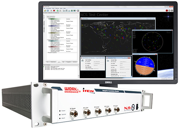
The absolute flexibility of the NavX-NCS Professional GNSS Simulator allows it to be configured with up to 108 channels and all of the following signals:
• GPS L1/L2/L5 C/A & P code and L2C
• GLONASS G1/G2 standard & high accuracy codes
• Galileo E1/E5/E6 (BOC/CBOC/AltBOC)
• BeiDou B1/B2
• SBAS L1/L5 (WAAS, EGNOS, MSAS, GAGAN)
• QZSS L1 & L1-SAIF
• IMESThe user is enabled to assign signals freely to any of the RF modules fitted to the simulator. This allows the same hardware to be used in a range of different configurations.
Signals may be added by software license with no need to return the hardware for upgrade.
Up to four independent RF outputs may be fitted, enabling the user to simulate multiple antenna locations simultaneously (allowing simulation of multiple antennas on one vehicle, multiple vehicles simultaneously, a mixture of static locations and mobile vehicles, and multiple antenna elements forControlled Reception Pattern Antenna [CRPA] testing).
The comprehensive and easy-to-use Control Center operating software allows the operator to quickly create realistic test scenarios for effective testing of user equipment.
IFEN also offers the NavX-NCS Essential GNSS Simulator, which is available with 21 or 42 channels and is capable of simulating GPS L1 (including SBAS L1), GLONASS G1, Galileo E1, BeiDou B1, QZSS L1, and IMES. The simulator is also supplied with Control Center operating software for comprehensive scenario generation.
www.ifen.com For USA and Canada
Mark Wilson
phone: 951-739-7331
email: [email protected] For Rest of World
Dr. Guenter Heinrichs
phone: +49-8121-2238-20
email: [email protected]
RaceLogic
LabSat 3
LabSat 3, the latest generation of GNSS simulators from Racelogic, is a low cost, stand-alone, battery powered, multi-constellation, RF record and replay device designed to assist GNSS engineers in the development and testing of their products. With its small size and all-in-one design, LabSat 3 makes it easier than ever to collect raw satellite data in the same environment that end users experience in everyday use. This enables repeatable and realistic testing to be carried out under controlled conditions.
LabSat 3 doesn’t need to be connected to a PC to record live-sky GNSS signals. With one-touch recording to SD card and a two-hour battery life, it can be used in any outdoor location to create real-world scenarios, for eventual replay back in the lab. As well as recording GPS, GLONASS, BeiDou, QZSS, Galileo, and SBAS signals, it can simultaneously log CAN bus, serial, or digital data, embedded alongside the satellite information. This additional information can then be replayed alongside the GNSS output, with synchronization to within 60 ns. A 1 PPS signal can also be generated using the internal GPS receiver.
LabSat 3 can be used as a replay system out of the box with a set of pre-recorded scenarios supplied as part of the package, recorded from various locations around the globe. SatGen software, a free version of which is included with LabSat 3, allows for scenario generation of user-defined trajectories, with precise control over velocity, heading, height, and constellation profiles. Routes are also easily created in Google Maps, and the software also supports NMEA and KML file import. SatGen gives the test engineer the ability to develop a product using simulations that would be difficult or impossible to record due to geographic location or safety constraints.
LabSat 3 is available in four variants: replay only, or record and replay, of a single channel — one of GPS/Galileo/SBAS/QZSS, GLONASS, or BeiDou; and replay only, or record and replay, of dual channels — two of GPS/Galileo/SBAS/QZSS, GLONASS, or BeiDou.
LabSat is currently used by many leading manufacturers of GPS chipsets, portable navigation devices, smartphones, and by major car companies in their test, development, and production processes.
www.labsat.co.uk; phone: +44 (0)1280 823803
Rohde & Schwarz
R&S SMBV100A: GNSS Simulator on Vector Signal Generator
Rohde & Schwarz extends the functionality of the R&S SMBV100A vector signal generator by adding BeiDou/Compass capability to its integrated GNSS simulator. With the R&S SMBV-K107 option, the GNSS simulator now covers the BeiDou standard as well as the GPS, Galileo and GLONASS satellite navigation systems.
The new option allows users to generate real-time scenarios with up to 24 BeiDou satellites. R&S SMBV-K107 supports all possible BeiDou orbits and can therefore even simulate satellites that are not yet in orbit. It also supports hybrid scenarios with GPS, Galileo, or GLONASS satellites. A software update makes it easy to upgrade existing GNSS simulators for BeiDou. No hardware modifications are required.
The R&S SMBV100A permits users to quickly define their own satellite scenarios to test GNSS receivers under diverse conditions. A wide range of options are available for simulating realistic effects such as signal obscuration and multipath propagation. These scenarios can now be configured for BeiDou as well.
This inexpensive solution is one of the few on the market that does not require an external PC for testing receivers and components of satellite-based navigations systems. In addition to GNSS signals, the R&S SMBV100A can simulate mobile radio, wireless, and radio standards, allowing users to test several functions with a single instrument.
The new R&S SMBV-K107 option is now available from Rohde & Schwarz.
www.rohde-schwarz.com email: [email protected]
Spectracom
Configurable, Upgradeable GNSS Simulators
Spectracom multi-channel, multi-frequency GSG Series GPS/GNSS Signal Simulators are designed for research, development and manufacturing. They provide powerful, affordable, and easy-to-use application-specific GNSS testing solutions allowing users to simulate virtually any condition through built-in and user-defined scenarios. The simulators now feature expanded capabilities and a flexible, field upgradeable design that allows users to select only the features needed for a specific application, upgrade when necessary.
The GSG 5 and 6 Series simulators are portable and fully operational via front panel, web-based remote control (Ethernet, USB, GPIB), or SCPI protocol. The models include GSG StudioView PC Software to build, edit, and manage complex scenarios and trajectories. Advanced simulation features include: SBAS (WAAS, EGNOS, GAGAN, MSAS), multipath scenarios, interference detection and mitigation, white-noise generation, and trajectories. The new features and capabilities can be added to any GSG-5 or GSG-6 purchased since June 2012.
GSG-6 Series Multi-Frequency, Advanced GNSS Simulator
• Up to 64 channels and 4-frequencies simultaneously
• GPS, GLONASS, Galileo, BeiDou
• Sync multiple units for testing hundreds of signals
• L1, L2, L2C, L5, E1, E5, B1; [E6, B2, B3 capable HW, with FW upgrade available in the future]
• P-code, pseudo P(Y) in L1 and L2
• Add-ons for real-time scenarios, record and playback, Assisted-GNSS, RTK/Differential measurements, high velocity
• Fully upgradable to future constellations and signalsGSG-5 Series Multi-Channel, Advanced GNSS Simulator
• 4, 8 or 16 channels
• GPS, GLONASS, Galileo, BeiDou
• L1, E1, B1
• Upgradeable to more channels and frequenciesGSG-51 Low Cost Single Channel GPS Signal Generator
www.spectracom.com email: [email protected]; phone: 585-321-5800
• 1-channel GNSS tester for fast, simple manufacturing test and validation
• Fully upgradeable to GSG-5 and 6 series
Spirent Federal Systems
GNSS Simulators
Spirent provides simulators that cover all applications, including research and development, integration/verification, and production testing.
GSS8000 (pictured). Spirent’s flagship simulator, the GSS8000, is fully approved for Y-code, SAASM, AES M-code and SDS M-code testing. Spirent provides options and configurations for testing GNSS interference effects and interference mitigation techniques, such as integrated GPS/inertial testing, CRPA testing, and jamming/anti-jam simulation.
Spirent has delivered simulators that produce legacy signals as well as modernized signals such as 2C, L5, and L1C. In addition to GPS, systems can include GLONASS L1/L2, Galileo, and Beidou-2, plus SBAS (WAAS, MSAS, and EGNOS) and Japan’s Quasi-Zenith Satellite System (QZSS).
CRPA Test System. Spirent’s Controlled Reception Pattern Antenna (CRPA) Test System generates both GPS L1/L2 and interference signals; multiple GSS8000 chassis may be combined to coherently control up to seven antenna elements. Null-steering and space/time adaptive CRPA testing are both supported by this comprehensive approach.
GSS7790. Spirent’s GSS7790 Multi-Output Simulation System allows the signal from each satellite to be mapped to a separate RF output. These signals can then be fed to individual transmit antennas, which, when suitably deployed in an anechoic chamber, replicate the spatial diversity of satellite and jammer signals incident on the receiver antenna. Additional flexibility is offered as the signal is further split into its GPS L1 and L2 components, as appropriate.
www.spirentfederal.com Jeff Martin, Director of Sales
Kalani Needham, Sales Manager
email: [email protected]
phone: 801-785-1448; fax: 801-785-1294 -

LabSat 3 Updates Include Extended Recording
photo: GPS World Racelogic’s latest update to the LabSat 3 simulator allows the use of 128-Gbyte SD cards, giving up to nine hours of high-quality RF recording. Also included in the update is the ability to use external USB hard drives and the addition of a serial/USB NMEA output, generated by the internal GPS engine during a replay.
The multi-constellation, stand-alone, battery-powered GPS/GLONASS/Beidou simulator is affordable and convenient, Racelogic said.
Along with SD card recording, LabSat 3 features inbuilt battery power, dual-channel recording of GPS/Galileo/QZSS/SBAS, BeiDou, or GLONASS, and logging of other external signals such as CAN and RS2232 — in a small, rugged, and light enclosure.
Existing LabSat 3 customers can get this update free of charge from here.
This video demonstrates the unit’s ease of use:
-
Racelogic to Launch LabSat3 at ION GNSS+
Racelogic LabSat 3 LabSat, the GPS record, replay, and simulation brand produced by Racelogic in the UK, is about to be augmented with the introduction of LabSat3.
The key feature of the new product is its simplicity. It is, essentially, a single-box device that incorporates a GPS record-and-replay system without the need for a laptop or PC. Racelogic has designed the LabSat3 with convenience at its core: it is small and light, allowing users to record GPS signals in any situation, the company said. It will also come with a pre-recorded library of worldwide scenarios to allow engineers to perform immediate bench testing.
The new LabSat is able to record signals from GPS, GLONASS, Galileo, BeiDou, QZSS, and SBAS, with the top of the range models able to output two channels simultaneously. Both the recording and replay procedures are simple one-touch operations, with data being logged to an SD card.
LabSat3 is compatible with scenarios generated with SatGen software for those that wish to create full simulations. Ethernet connectivity extends its potential to end-of-line testing where multiple units can be remotely controlled, with potentially large savings in production line testing times.
LabSat3 is set to be launched at the ION GNSS+ exhibition in Nashville next week. Prices will start at $4,400. For further details, visit the LabSat website.
-

Transitioning to a Commercial Business Model
How Navsys Leverages Military Expertise for Business
The financial landscape is changing in a number of ways for a lot of GNSS businesses due to the U.S. government sequester and to a larger extent due to the U.S. reduction in military spending. The larger multinationals and prime contractors may have achieved pretty well diversified scope for their operations, and most have existing commercial products or operations where they can pump up resources and investment to improve their commercial market and product positioning. But a number of small businesses have discovered that their military and government clients of the past no longer have the same level of funding available for key projects. So their search is on for commercial opportunities, and the transition to a commercial business model may present a significant change in the way they operate.
Navsys Corporation in Colorado Springs is located just outside the gates of the U.S. Air Force Academy, so it’s not unusual that its customer base reflects a close association with the U.S. military and its prime contractors.
When someone in the military had a challenging GNSS or related technology problem in the past, it was often Navsys who was able to offer an innovative solution, through a Small Business Innovation Research (SBIR) proposal — and the company was actually awarded nine SBIR Phase II contracts over the last five years. Phase II SBIR contracts are designed to transition mil technology into commercial products either via government organizations or commercial outfits. Often in the past, prime contractors responding to a larger mil-spec requirement would also roll Navsys into their response when part of the requirement involved a GNSS navigation or related solution. So since 1989, the development of GNSS technology and products, and the publication of papers describing those technologies and products, have been pretty continuous at NAVSYS:
- Extended wide area differential GPS
- WAAS bent-pipe signal generator (SIGGEN)
- GPS/inertial video registration
- Digital beam-steering GPS receiver
- JLOC Jammer Detection and Location system
- Indoor location
- GPS phased sensor array
- Software-defined receiver
JLOC has been a long-term active government project for more than 10 years. SIGGEN technology has been part of Japan’s MSAS system for more than 10 years, and is an example of a successful product that has transitioned from government research into the commercial sector. And, of course, the first GPS-enabled cell phone, developed by Navsys Corporation, is now on display at the Smithsonian National Air and Space Museum’s Time and Navigation exhibition in Washington, D.C. Developed for the Colorado Department of Transportation’s Emergency Vehicle Location System Mayday platform in 1995, this important step in GPS history paved the way for positioning to become an integral component of today’s communications technology.
The complement of professionals on staff at Navsys has changed throughout the years, driven largely by how many projects were contracted at any one time, but the group has always had a very high standard of qualifications and experience and has inevitably exhibited a large degree of flexibility and creativity. Nowadays, moving to better align with commercial opportunities, Navsys helps companies solve challenging problems relating to GNSS, inertial, and simulation/testing. Cultivating business-to-business partnerships allows the company’s technical expertise to compliment and strengthen end-user products or applications. So companies are able to use Navsys as a technical resource for product development at a lower cost than developing their own in-house navigation solutions. And many of the technologies and core capabilities that they turn to stem from prior research and development into government and military applications. As projects mature, they transition into industry-leading products and services. Navsys’ industry partners and customers then go on to customize these capabilities into commercial applications in the marketplace.
One of the key technology/products that Navsys is pursuing includes InterNav modular GPS/inertial embedded software. It provides a real-time tightly coupled GPS/inertial solution that can be precisely aligned with additional sensors, including digital video products and laser rangefinders.
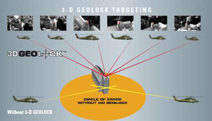
InterNav software provides geo-registration for SAFIRE. Photo: NAVSYS InterNav software may be embedded into OEM applications including commercial-off-the-shelf GPS/INS systems, unmanned platform navigation and stabilization systems, and remote sensing geo-registration. The above graphic shows how InterNav provides highly accurate geo-registration for FLIR’s Star SAFIRE electro-optic imaging system.
With other key customers such as KVH also using InterNav in some of its integrated inertial products, Navsys appears to be well on its way to penetrating a market segment that has previously been a space occupied by companies such as Applanix, Teledyne, and iMAR.
Another area where Navsys has had some success is GNSS simulation and test. The GNSS Signal Architect product suite includes Simulation and Toolbox software and test-set hardware.
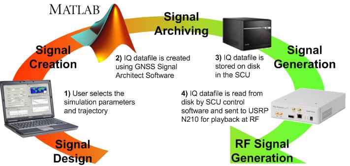
Photo: NAVSYS Simulations of GPS or GLONASS are created based on static or dynamic scenarios. Users specify a complete set of simulation parameters, including receiver/satellite profiles and delay/noise error modeling. Playing back the simulation as an RF signal provides accurate and repeatable signals for GNSS receiver testing.
Signal architect user. Photo: NAVSYS Toolbox includes a number of GNSS MATLAB utilities, including geographical, satellite geometry and receiver design/analysis tools. Test set is made up of a signal control unit computer and a software-defined radio and includes a wideband transceiver daughterboard.
Navsys has in the past provided extremely accurate GPS scenario generation software for end-user GPS simulator products, and the SatGen GNSS signal generator has also been released by Racelogic using Navsys Signal Architect Signal Simulation software.
Other technology/products currently in the works include Precision Geo-Registration and Remote Sensing, Geo-Referenced Imagery, Video-Aided Inertial Navigation and GNSS/Inertial Simulation.
- GPS/inertial InterNav technology has been used to develop Precision Geo-Registration and Remote Sensing, which extracts precise coordinates from video imagery without requiring any known data points. The key technology advantage is a precision GPS/inertial alignment technique that enables accurate camera alignment and aiming (<1 mrad attitude) using only low‐grade inertial sensors.
- Video-Aided Inertial Navigation uses an algorithm update technique that leverages image aiding from tracking ground points to further refine alignment accuracy. When combined with the GPS/inertial alignment algorithm, significantly improved alignment accuracy can be achieved over current GPS/inertial integration approaches.
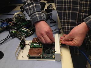
Photo: NAVSYS So, as defense spending continues to contract, Navsys and other similar companies with an existing “treasure chest” of technology created for previous military programs are successfully adapting. Not only are skillfully modified, repackaged or even further advanced technologies and products being brought to the commercial marketplace, but their approach to business development, marketing and sales is beginning to take on the face of commercial operations. Business plans, carefully chosen projects and internal investment are beginning to replace responses to Commerce Business Daily (CBD) and Federal Business Opportunities (FedBizOpps) as a way to conduct business. It’s a brave new commercial world out there and Navsys amongst others is ready, prepared and able to adapt and succeed.
Tony Murfin
GNSS Aerospace -
Waterproof Datalogger
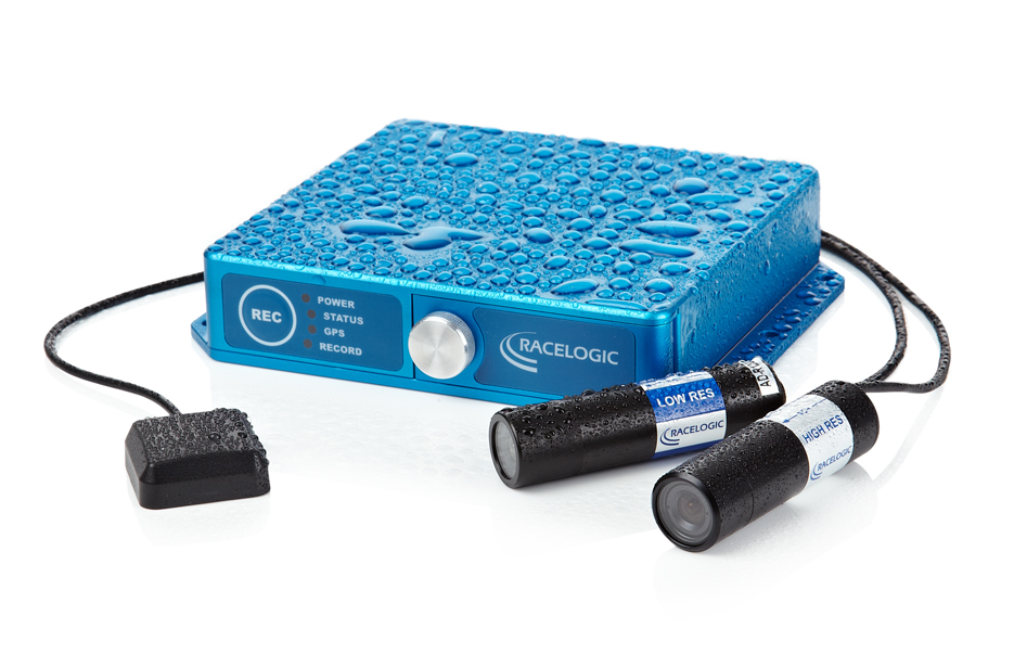
Photo: Racelogic Video VBOX Waterproof by Racelogic combines a powerful GPS data logger with a high-quality multi-camera video recorder and real-time graphics engine, allowing users to carry out detailed driver training and vehicle analysis whatever the weather. Housed in a water-resistant anodized aluminium casing (IP66), Video VBOX Waterproof incorporates a flange and mounting holes to permit users to bolt the system anywhere on their vehicle.
The unit takes video from up to two bullet cameras and combines it with a customizable graphical overlay, recorded on to SD card or USB stick in DVD quality. It is designed for a variety of applications from automotive testing to motorsport, driver training, and industrial applications.
-
LabSat 2 Customers Offered Free BeiDou Upgrade
LabSat 2 now has the ability to record and replay satellite signals from the rapidly expanding Chinese navigation system, BeiDou. LabSat 2 users can now record and replay any combination of two channels from the three available constellations, GPS, GLONASS, and Beidou.
Existing LabSat 2 users can download the latest firmware (v2.0.0) and PC software (v2.6.14) to add this functionality with no cost.
There is a growing trend to include multi-constellation capability into new satellite navigation receivers, giving the end user better coverage in urban canyons, and overall improved positional accuracy, LabSat said.
There are now 14 operational Beidou satellites, and we have recorded a number of different files from Europe and China containing between 6 and 8 satellites. These scenarios are now included on the hard disk which is shipped with a LabSat 2, which can also be shipped out to existing customers on request.
The new firmware and software is now available from the Support section of the LabSat website. Follow the upgrade firmware instructions in the manual to upgrade your LabSat 2. For more information contact our LabSat Product Manager, Mark Sampson, [email protected].
-
Racelogic Wins Two Queen’s Awards for Enterprise
Simulator company Racelogic, based in the United Kingdom, has been honored with two 2012 Queen’s Awards for Enterprise. The awards were given April 21 to 209 companies to mark Queen Elizabeth’s birthday. Racelogic was one of four companies to be honored with the awards for both Innovation and International Trade.
Racelogic won the Innovation award for advances in GPS/GLONASS test simulation, with customers such as Broadcom, ST-Ericsson, and Telefonica using LabSat to test their devices.
Almost 90% of Racelogic’s sales are now to countries other than the UK, with customers in 92 countries around the world. Racelogic received the International Trade Award to recognize this achievement.
“We are extremely proud to be named as a winner of these two awards, with many highly reputable companies in the UK competing for these honors,” Racelogic’s CEO, Graham Mackie, said. “As a company we continue to grow and now employ more than 50 people in the UK alone. We have distributors located all over the world who help us to market and sell our systems to a wide variety of markets and customers.”
All winners will be invited to collect their awards at a reception hosted by the Queen in Buckingham Palace later this year.